GEOLOGY AND GEOGRAPHY OF LYR by Chris Wayan, 2006
Lyr (home) - map - creatures - cultures - evolution - climate - geology - gazetteer - nomenclature - definitions - building Lyr - more worlds? Planetocopia!
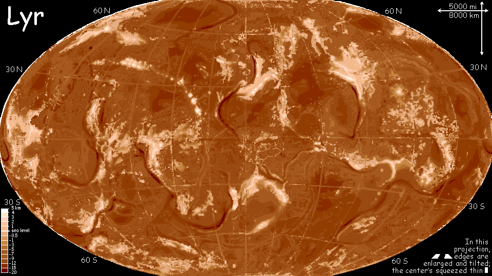
LYR'S TECTONICS
Lyr is a tectonically busy world, for three reasons:
GENERATING CHAOS
How did I create the geology and geography of Lyr? Well... I didn't, exactly. I wanted a geography I discovered somehow, not a world I'd created through conscious artistic decisions. Two reasons for this:
So for the big picture, blame Alea, the goddess of dice and chance, and her austere sister Cartographea. Lyr is 95% theirs, not mine.
This is new for me. The geography of all my earlier worlds in the Planetocopia project were pretty much givens--based on Earth, Mars, Venus, and so on. But for Lyr I wanted to keep that "given" quality, and for that I needed to create without creative control.
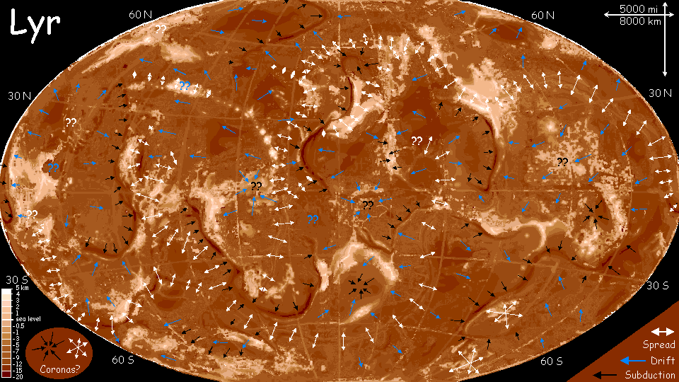
RIDGES AND TRENCHES AND PLATES (OH MY!)
As I say, I did tweak a little. Mostly I highlighted implied trenches and rifts. Chaos doesn't generate linear features well, and I think Lyr will have tectonic plates. But fractured ones--Lyr has a bubbling mud-pot quality, like Venus. While Lyr's plates and rifts are often Terran-scale, look how many there are! Lyr is shattered.
And the plates move more chaotically--trenches don't always suggest neat lateral motion, but rotation or rocking or tilting or confusion. Flexing, fraying? Are these plates rock or rubber?
There are quite a few spots, like the Dahia and Borthu Is., where the crust seems to be spreading in all directions, welling up a cloud of cream in coffee. Yet implosions can be found too--crumpled, puckered basins of infalling crust up to several thousand km across, like the center of the Flandry Group, or the Hisagazi Is. in Polesotechnica. Such round or oval upwellings and downwellings look a bit like the coronae of Venus, though Lyr's are rarer and mostly bigger. Still, Venus's Artemis Corona rivals anything on Lyr. Coronae seem to happen only in very hot mantles and crusts, like Lyr and Venus; presumably it takes a certain flexibility Earth's colder, brittle plates lack. Though the tormented ridges of the Mediterranean, monuments to the death of the Tethys Sea, resemble Hisagazi's twisted topography.
Terran rifts all link into a simple system, rarely branching, but Lyr's are a tangled mess--they make little geological sense. But plenty of Lyrological sense! Big, hot, hyperactive mantles will act unpredictably, and complexly--like Jupiter's many belts and cells. Storms written in stone! Next to Lyr, Earth is small, cool, simple and chunky. Just as Mars, half our diameter, looks to us!
Only 4.5% of Lyr's surface is land. But that's 45 million square miles (115 M sq km)--three-fourths as much land as Earth! Another 3% of the surface is continental shelves, and mid-ocean shallows, reefs and seamounts are another 2%. Total highlands: 9-10%. Compare this to Earth, 30% highlands; Venus, 8%; Mars, 50%; it's not surprising that Lyr's ratio resembles Venus, hottest inside of the three.
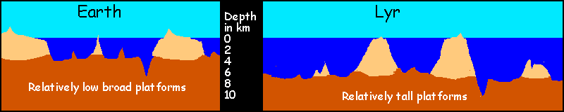
Lyr's tectonics create light continental rock a bit faster than Earth, over an area as big as 5 Earths, and over 7 billion years (these rocks increase over time; even a billion years ago Earth had less land). Today, Lyr has 12 times Earth's continental rock. Wherever it does break the surface, erosion shapes it into narrower, taller platforms than Earth's. This is inevitable--weathering on both worlds is much heavier above the waterline, so most continental areas will be near sea level, whether high or low. Any world with seas, rain and active tectonics will spread its light rocks out near the waterline, maximizing its potential land area.
But even the basaltic sea-floor flows, in deep time--indeed, Lyr's abyssal creep is faster than Earth's. This speeds the accretion of islands and rises into Earth-sized continents. That speed is needed! Lyr's seas are so huge, continental accretion still takes a long time--after eight billion years it's still rudimentary compared to Earth. You'll notice how much more broken-up Lyr's land looks; Earth seems blocky, almost as chunky as Mars.
The net result: Lyr's lands are scattered, spidery and proportionately small--but not just a few mountaintops poking above the sea.
Given Lyr's high gravity and sea level, it's amazing how tall its mountains get. Its vigorous tectonic activity is one cause; another is the fact, little-known except to marine geologists, that water supports steep slopes and even cliffs very well; if Earth's oceans were removed, a spectacularly rugged world would be revealed. (Oooh! I'll try it. And name it Siphonia. Sorry. "I can resist anything but temptation"...) Nor is erosion anywhere near as severe underwater. It's just not that hard to build a platform or ridge up to Lyr's surface, given two vigorous plates and 100 million years or so; it's only the above-water parts of Lyr that really suffer. Since most land on Lyr is maritime, rainfall (and thus erosion) are on average higher than on Earth with its great deserts. And Lyr has less land overall; just 3/4 that of Earth. The result is an altitude range comparable to that of the Pacific Rim.
However, the numbers below are a bit deceptive. Lyr's air pressure drops off more quickly due to higher gravity, so climbing 3 km is climatically and biologically more like 4 km on Earth. Thus, Lyr's highest ranges, though merely Alpine by the numbers, block storms, grow glaciers and affect climate as if they were as tall as the Andes. For more see Lyr's Climate: Altitude.
| Name | Height | Location | Type | "Climatic" height (see above) | Life zones & climatic effects
| Arinnian
| 5100+ m, 16,800'
| southern Oronesia
| shield volcano
| 6800 m, 22,300'
| Hawaiian wet/dry sides; alpine gryphon habitat on shoulders
| Moonhorn
| 5000 m, 16,400'
| northern Roland
| shield volcano
| 6700 m, 22,000'
| massive, glaciated upland generating cold dry winds
| Li
| 4900 m, 16,100'
| Li, in Oronesia
| shield volcano
| 6550 m, 21,400'
| alpine island above subtropical rainforest; gryphon habitat
| Farview
| 4800 m, 15,800'
| Corona's south coast
| stratovolcano; plate edge
| 6400 m, 21,000'
| Mediterranean to Alpine; narrow zones foster rich mixed cultures
| Subotai
| 4800 m, 15,800'
| western Altai, south of Flandry
| shield volcano
| 6400 m, 21,000'
| massive, glaciated upland, generating cold dry winds stunting region
| Narpa
| 4700 m, 15,400'
| northern Starkad, in Flandry
| Shattered stratovolcano, once Lyr's tallest peak; summit now a cliff-arc
| 6300 m, 20,600'
| Explosions devastate region short-term, enrich/enlarge, long-term
| Hrill
| 4600 m, 15,100'
| southern Oronesia
| shield volcano, huge cliffwalled caldera
| 6150 m, 20,100'
| Hawaiian wet/dry sides, alpine shoulders, near-Martian summit caldera
| Delp
| 4600 m, 15,100'
| Holmenach (western Diomedes)
| stratovolcano bursting through uplifted metamorphic strata; plate edge
| 6150 m, 20,100'
| Mediterranean to Alpine; narrow zones foster rich mixed cultures
| Tridaig
| 4600 m, 15,100'
| southern Merseia, in Flandry
| massive shield volcano
| 6150 m, 20,100''
| extensive glaciers; rainy east, rainshadow of savanna/prairie to west
| Eyath
| 4500 m, 14,800'
| southern Oronesia
| shield volcano, huge caldera
| 6000+ m, 19,700'
| Hawaiian wet/dry sides; sky-island of alpine gryphon habitat
| The Weathermothers
| 4500 m, 14,800'
| Corona's south coast
| stratovolcano atop uplifted metamorphic strata; plate edge
| 6000+ m, 19,700'
| Mediterranean to Alpine; narrow zones foster cross-species contact
| Bourtai
| 4500 m, 14,800'
| central Altai, south of Flandry
| stratovolcano; a steep cone
| 6000+ m, 19,700'
| glaciated freestanding giant, generating cold dry winds
| Tarnberg
| 4500 m, 14,800'
| central Troisleons
| sedimentary, uplifted, continental spine; the Rocky Mountains
| 6000+ m, 19,700'
| Mediterranean feet to alpine crown; strata create cliffs, waterfalls
| |
|---|
WHAT IF THE GLASS WERE HALF FULL?
What if Lyr had been drier, with oceans about as deep as Earth's? The map below gives you some idea. It's not enough to just re-color the altitude map to establish a coastline three kilometers lower; other factors come into play. Sediment from all those vigorous mountains fill many of the shallower sea-basins, especially in rainy areas with muddy rivers. Most of the dark green plains are such sediment. Of course this happens on Earth too; much of what we think of as "solid" continental blocks are really just sediments filling in between upthrusts. Raise or lower the sea level and our familiar landforms wouldn't last long. The experiment I mentioned above, Siphonia, is pure play; drain our seas, and the continental platforms wouldn't last a million years. Lyr's former lands, now uplands, would be massively resculpted too. So don't take these highlands seriously; they serve mostly as markers of the old continents.
So with those warnings in mind, here's a snapshot of Lyr's face if it had been just a little drier... just seven times the seas of Earth!
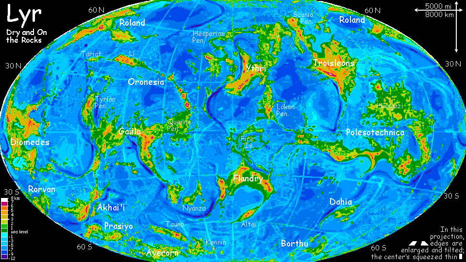
Without Lyr's excess water, is it just a big Earth? Well, yes and no. The continents postulated above are certainly chunkier and more Earthlike than Wet Lyr's; but they still have a stringy, slightly bubbly look that may remind readers of altitude maps of Venus. As usual, Lyr's halfway between the two! Given Lyr's hot, flexible rocks, intermediate between the bubbling Venerian mudpot and the rigid plates of Terra, this may be inevitable; certainly the sea-level experiment shows it's not the water's fault!
Dry Lyr also looks, well... overdone. Too much of everything--like an amateur worldbuilder going crazy, trying to cram in too many continents and seas. Look at just one quadrant of the map, and it seems more reasonable--quite Earthlike. Of course, you're now looking at an Earth-sized area! But I don't think this feverish quality is a function of Lyr's size, except indirectly; again, it's the heat. Lyr's plates, such as they are, are no bigger than Earth's; its surface is much more fragmented. While archipelagoes and clusters consolidate into true continents on Dry Lyr, it's still Lyr: chaos written in stone.
HOT SPOTS
Beside plate-chaos, Lyr is crawling with hot spots. These generate huge volcanoes in rather unearthly patterns. On Earth, as a plate slides over a hot spot, a line of volcanoes streams behind it, steadily older, less active, more eroded--first isles, then atolls, then mere seamounts. A simple plume.
But on Lyr, you get oddities like Li, in Oronesia, where a second hot spot seems to be chasing the first, and a third... or is that a pair? Li looks more like Java or Kamchatka (plate-edges) than a Terran hot spot. And it has a double line of volcanoes, though one's less obvious. What's going on here, is a new mid-ocean rift forming? These hot spots may be lava plumes fusing to form a new seam.
THE IMPACT OF IMPACTS
Lyr is big, and its gravity pulls in a lot of deadly rocks. Catastrophic impacts are more frequent than on Earth; and they shape life more. Worldwide tsunamis devastate lowlands around the planet every few dozen million years. (Another reason to be winged on Lyr! Large wingless species, the equivalents of our elephants, tend to go extinct during these catastrophes; fliers are far more likely to survive at least the initial flood.) I admit the only evidence for these impacts is biological--the rarity of big lowland animals. Even on the smallest-scale maps here, not a single crater's visible today. But then, Lyr is just too active for craters to last long, and only 5% hit land.
So do these unseen impacts have any geological effect? Well... I think they'll leave behavioral scars. There's some evidence Venus suddenly went geologically crazy, half a billion years ago; I think the most plausible cause is a large impact. I hope Venus will eventually prove that such shocks can be a tectonic wake-up call. They don't necessarily impart that much energy to the deep system, but Lyr's skin is so thin that puncturing plates is easy. If the sea floor is reasonably (relatively) near the surface, as in some continental clusters, an impact may create a new land rather like Iceland over the next few million years. And all those volcanoes cover up the crater-evidence...
Comet chains, if the impacts are close enough, might even crack a plate in two. Maybe even Terran rift zones weren't originally so much a manifestation of deep convection patterns as opportunistic. Magma oozes out cracks provided--maybe convection's chaotic, organized more from chance seeds--and those, on a world like Lyr, often fall from the sky!
Lyr's face is as patchy and seamed as Frankenstein's. Some of this is surely due to more complex convection in the mantle, but maybe all those extra impacts tear open new seams.
This notion of mine is admittedly tentative. But our solar system has no giant rocky planets--imagination's all we've got. And analogy. Consider: Saturn appears to have seasons, even though the sun's just 1% as bright. The amount of solar heating's trivial, yet it tips a huge convection system into cyclic changes. Well, isn't geology really just slow, dense weather? Both are just heat convection patterns, in the end. Is it so absurd that impacts might be seeds crystallizing the chaos?
If a glimmer of light on Saturn can do it, a wallop surely can.

Gazetteer: index of places, with descriptions. Or...
TOUR LYR! Climb volcanoes, swim seas, meet weird creatures. First: survival tips! Then, pick a region:
Ythri -- Polesotechnic Chain -- Troisleons -- Roland -- Oronesia -- Gaiila -- Flandry -- Diomedes -- Ak'hai'i -- Averorn
Lyr's homepage - map - creatures - evolution - climate zones - geology and geography - gazetteer - nomenclature - definitions
World Dream Bank homepage - Art gallery - New stuff - Introductory sampler, best dreams, best art - On dreamwork - Books
Indexes: Subject - Author - Date - Names - Places - Art media/styles
Titles: A - B - C - D - E - F - G - H - IJ - KL - M - NO - PQ - R - Sa-Sk - Sl-Sz - T - UV - WXYZ
Email: wdreamb@yahoo.com - Catalog of art, books, CDs - Behind the Curtain: FAQs, bio, site map - Kindred sites