

Ak'hai'i, Trillia and Hroai
by Chris Wayan, 2006
dedicated to Poul Anderson for his remarkable world-building
Lyr (home) - map - creatures - cultures - evolution - climate - geology - gazetteer - nomenclature - definitions - building Lyr - more worlds? Planetocopia!
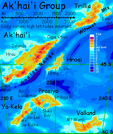
The Ak'hai'i Group is a large but lonely cluster in the Southern Hemisphere, 6000 km southeast of Diomedes. The six major lands are Ak'hai'i, Trillia, Hroai, Ya-Kela, Prasiyo, and Valland, totaling 3.1 million sq km (1.2 M sq mi, the size of Western Europe). Ak'hai'i proper is nearly as big as the other five together. The region's cool to temperate, with gentler terrain than much of Lyr. The only flyways are from the Rorvan Is. to the west and Carnoi to the north, plus a passage to even colder and lonelier Averorn to the south.
THE HRAU ARCHIPELAGO
If you fly in from the Rorvan Isles, you're probably exhausted--or dead. From the last islets east of Menusha, it's an unbroken 1700-km flight over deep sea. Even an arctic tern would rather rest now and then!
At least the Hrau Islands are friendly for tired travelers. Though small, they're forested down to the high tide mark; shelter and drinking water are easy to find.
Nor will you face any more long flights. Though the Hrau reef complex is 2700 km long (1700 mi), its dozens of narrow sinuous islets follow the rim of the shelf with no gaps wider than a couple of hours' flight. Just follow the dotted line to the mainland!
Though some of them are more like dashes--Hrau, just off the mainland, is a good 120 km (75 mi) long. But all are slender, mostly less than 20 km wide. And low--the highest peak in the archipelago is under 100 meters, and ten is a respectable hill. The Hraus are coral islands, the southernmost on Lyr, in a warm current sheltered by the mainland of Ak'hai'i to the south.
Who lives on the Hraus, who can you stay with? Most locals are icari from the northwest, plus a few sphinxes from the northeast. Though a warm current bathes the Hraus, the weather's too cool and misty for antel, koreens, or griffets.
Witweets, the only intelligent species native to this region, could bear the weather--but they don't settle islands, for they're gliders, not fliers, and reluctant sailors at best.
MAINLAND AK'HAI'I
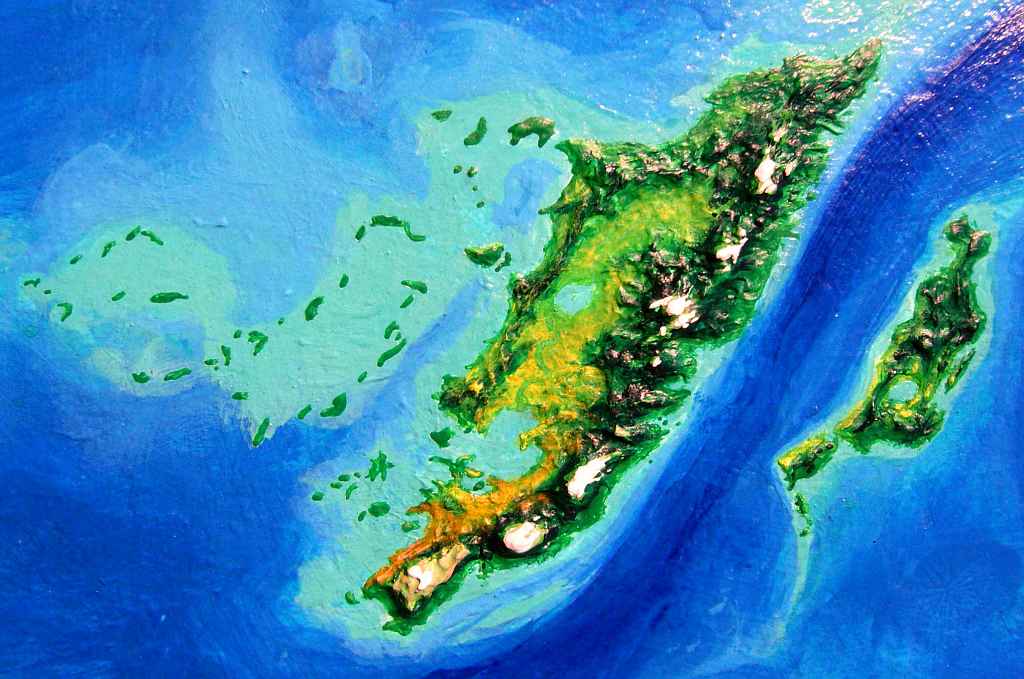

After a week or two of threading through the Hraus, a long line of hills rises from the sea--the west coast of Ak'hai'i. The land looks very Terran--low hills, open forest, scattered meadows on the slopes facing the sea, where the afternoon sun dries out the soil a bit more. The breeze off the sea blows inland, and you ride the updraft, up to gentle, rounded summits. From the ridgetop meadows, you get glimpses of snowy peaks far to the east--the Gneiss Range (pronounced g'nice--it's the hard, metamorphic rock underlying the range). On the coast you spotted one sphinx village; inland, just icari. Though Ak'hai'i's famed for witweets, you won't see any here--they only feel secure in the deep woods found in the north and east coast.
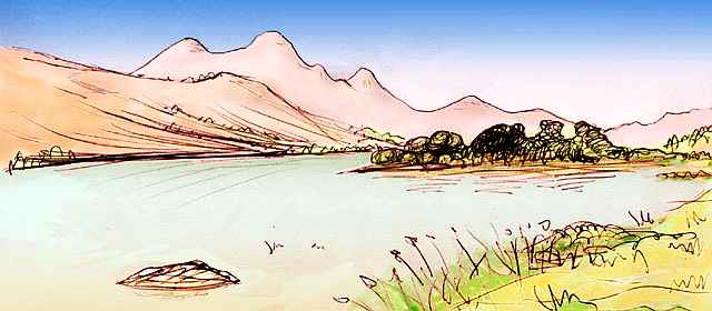
At last the hills recede. A great bowl lies between us and the Gneiss Range, twice the width and length of California's Central Valley. A great silvery sheet pools in its heart: Lake Riao, largest on Ak'hai'i. It's a chevron or rough arrowhead 120 km (80 mi) long, pointing northeast, where the hills grow higher and dark with pseudopines. But we're headed the other way, down the Oaua River ("Oh! A wah!").
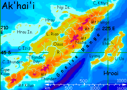
Watering most of Ak'hai'i, the Oaua runs nearly 1000 km (600 mi) west along the foot of the Gneiss Range, meandering down to Thunder Bay. The Oaua Basin looks like northern California--mixed groves and meadows, in a mild climate with light rains. Summers don't get as hot--Lyr's dense air and short day both moderate temperature spike, and we're further from the equator--but they do stay dry for several months, except for coastal fog. As I said, a quite Californian pattern.
Thunder Bay is 320 km (200 mi) wide, really a sheltered inland sea--the Thunder Islands and the many fingers of Cape Thunder to the west nearly block its mouth. The flow from the Oaua River delta makes the inner end of the bay nearly fresh. The region's dry for Ak'hai'i; the shores are mixed groves and meadows. Icari and sphinxes still predominate. A few pioneer villages of witweets huddle in the largest groves--long strips on streambanks--but their talent for gliding short distances is useless in most of these low, sparse woods and open meadows. You visit one village, briefly, and are careful not to blurt your first impression--live teddy bears. Which they're not, unless your childhood toy could uncurl a long whiplike tail, spread skin-flaps like a flying squirrel, and glide between trees...
Off to the right (north) is low, wide Cape Izizi, a squarish peninsula 260 km (160 mi) across, with low ridges and valleys, each with a wooded east face opening to savanna studded with "oaks" on the ridges and west slopes. Again, quite Californian--or Portuguese. Sphinxes and icari tend fruit and nut orchards here along streams, and fish the coasts; but the grasslands, away from water, are largely left wild.
The region's so sunny because most storms founder on the slopes of the Gneiss Range to the east, especially Mt Thunder, a complex of rugged spires up to 3800 m (12,500') on the southern coast
Further south is a strange, empty land: Cape Kiluo. The southern tip of Ak'hai'i, it's 500 km long and 200 wide (320 by 130 mi). Much of it's a lava plateau over 2 km high (7000') centered on Mt Kiluo, 3600 m (11,900'). You climb to the rim of the plateau just to see. It's subalpine, a cool grassland broken here and there by cliffs where lava flows ground to a halt or streams have cut through banks of tufa. A couple of these breaks near lakes with good fishing have icarus villages, dug in like cliff-swallows--windows, doors and landings opening on naked air. But such villages are sparse; it's a lonely plateau.
We needn't go down the cape; it's a dead end. In two senses! Yes, it's a flyway to nowhere, but the tip is also one of the few utterly uninhabited lands on Lyr. Rainshadowed by the uplands, it's a narrow desert strip 250 km long. Floxes or pegasi or even cheetaurs might like it, but none of these species has made it this far south. (There's one more northern species that hasn't reached Kiluo yet, but unlike the others, it really may settle here soon--you'll be meeting them tomorrow).
The next day, you fly northeast up the length of the Thunder complex, which tops out at 3800 m (12,500'). You soon learn the name's not poetic. Now, in summer, its sharp crags make clouds from the east pile up and rise to great thunderheads. You fly warily, veering around slaty cloud-castles with crackling spiderlegs of fire.
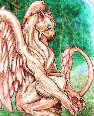
Here in the Gneiss Range you encounter an unexpected species: gryphons. These people of the far north are the last you'd thought to find here! Odder still, they came from the south, from Averorn, where they settled in recent times (as Lyrans measure it). These huge, hawk-headed, leonine people really do resemble some heraldic fantasy. And their code fits: they value honor, sober speech and strict honesty, giving even the Trade tongue a formal dignity. Though their lives are a bit more prosaic: herding meat and dairy animals on the subalpine meadows, building stone keeps, and of course squabbling over grazing rights. Gryphons are territorial, and their territory's limited: the lowlands are too hot for them.
They herd for meat and milk, but not for any equivalent of wool, for a gryphon's own coat is the finest on the planet, rivaling a polar bear's. It's ideal for the chilly uplands of Kiluo, and their herding lifestyle suits that grassy plateau, but the gryphons simply haven't spread that far yet; they've only been on Ak'hai'i a couple of generations. Scouts have reported favorably, but are still studying the soils and negotiating trade agreements with icarian fishing villages. Lyran change, based as it is on consensus between the land-use needs of physically diverse peoples, is necessarily slow. But they'll get there; the fit is obvious even to a tourist like you.
Beyond the Thunder complex, the Gneiss Range slowly slumps; gradually the gryphon keeps grow sparser until they cling to mountain tops no more than 2 km high--to a gryphon they're islands of cool in a sea of heat. While you shiver! Instead of the gryphons' flocks in alpine pastures, you start seeing icarus orchards among the deepening woods.
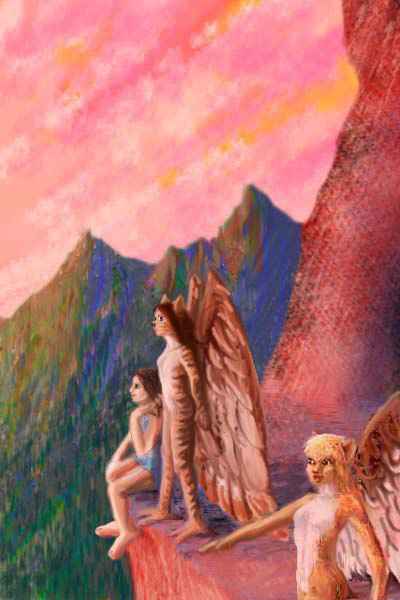
You stay the night in a lakeside cliff-eyrie; sunset is sober, hidden by black silhouetted summits, but sunrise makes up for it--a scarlet extravaganza. The icari wake and greet the day with you, on the eastward terraces, singing. As you dangle your feet over the sheer drop, you feel like Bilbo Baggins among the eagles.
Today you slip down the mountain slopes to explore the west coast. The mountains wring rain from every front blowing in off the Tempest Sea, and the coast is lush. Witweet country! You look forward to really meeting these reclusive people, but you quickly learn meeting is not understanding. This gentle, amiable people live in their own world, shaped by scent and sound. They export herbs, spices and scents, and they'll talk about these eagerly with you, but their inner life isn't in trade--or expressible in Trade.
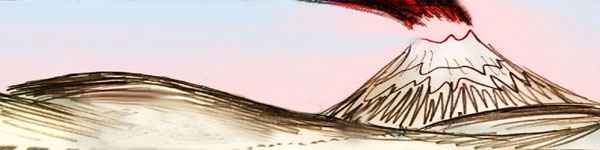
The next day, the line of peaks inland grows higher again--icy claws punching up through the cloud-wrack. Toward sunset, one giant casts a long shadow on the sunset clouds above you and 100 km out to sea: Mt Nadia. Highest peak on Ak'hai'i, at 3900 m high (12,800'), it marks the start of a northern gryphon-haven 800 km long, studded with similar volcanoes every hundred km or so.
It reminds you of the Cascade Range. You wonder if these peaks are as dangerous as Mt St. Helens and Lassen, but when you stop for the night at a fishing village on the coast, the local icari recall several eruptions, but nothing explosive.
This isn't luck; Lyr's larger than Earth, with stronger tidal stresses, and its magma is usually hotter. Though some lava fountains air-cool to create cinder cones just as on Earth, large lava plugs form less often and melt more easily, so on Lyr even stratovolcanoes (steep cones as in Java, the Cascades or Japan) erupt often but more peacefully--almost like Hawaiian shield volcanoes.
Catastrophic mudflows can swallow whole villages, but the locals don't worry much about it, for on Lyr, unlike Earth, mudflows rarely kill. Another advantage of wings! Even a few seconds' warning is enough for fliers to escape a torrent of boiling mud... where humans would have just enough time to realize they're doomed.
On the other wing, thick-magma volcanoes are always dangerous. When a vent like Mt St Helens gets plugged, swells, and explodes, that deadly pyroclastic cloud outflies even a Lyran at top speed.
So the chemistry of magma matters--but so does its sheer heat. Lyr bubbles with volcanoes and suffers few explosive catastrophes for precisely the same reason!
In the morning, you cruise on steadily north. An hour before noon, you're abreast of Mt Sten, a peak 3500 m (11,500') high. The foothills are now dense "redwood" forest, far rainier than the coast behind you.
Ahead looms an even higher peak, Mt Henge. Like the Thunders far to the south, Henge is less a mountain than a range--a ridge miles long, cresting at 3800 m (12,500'), a wall so high as to be impassible to most fliers. This side side is scored by many steep short canyons; on the hidden side, Henge's glaciers and alpine slopes collect many streams to form the Oaua River, longest on Ak'hai'i.
Further north is Cape Ktiya, the northeast tip of Ak'hai'i. Mild climate and heavy rains support a warm-temperate rainforest--and the densest population of witweets on Ak'hai'i. But are we going that far?
Here at Mt Henge's foot you face a choice:

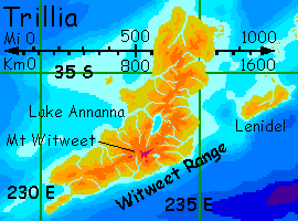
TRILLIA
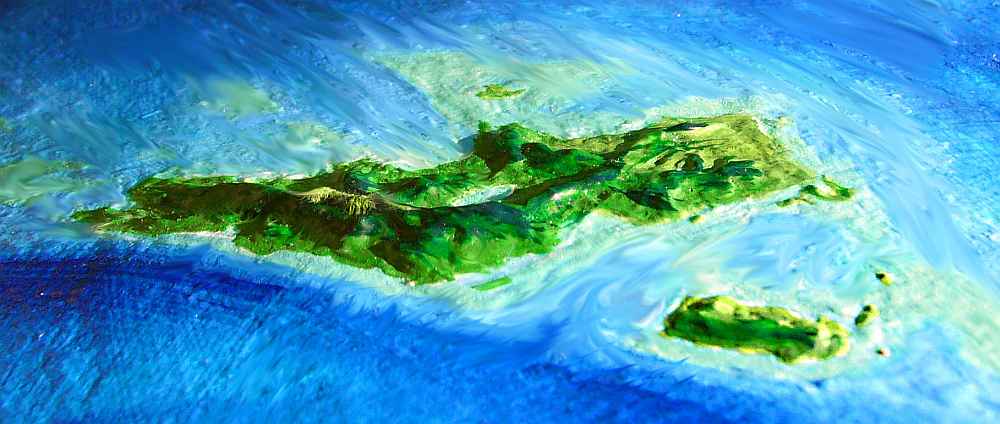
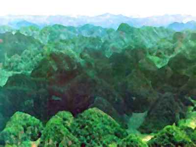
Northernmost land in the Ak'hai'i Cluster south of Diomedes, Trillia's 1350 km long (850 mi)--about the size of Madagascar. Trillia is rainy, subtropical, and densely wooded--lowland rainforest, cooler upland cloudforest. Only the highest peaks of the Witweet Range open into subalpine meadows.
I'll assume here that you flew north from Ak'hai'i, not south along the long Lenidel Chain from the Gaiila Cluster. My apologies to the minority of you entering from the north!
Your first glimpse of Trillia is Cape Southwest, a narrow chain of jungle hills rising in cliffs from the sea. There's nowhere level to land; all is canopy. Even overhanging cliff-faces are moss-streaked and vine-draped; you have to fly on until you spot a witweet village in the treetops and land, exhausted.
Witweets look like big-eyed hybrids of poodles and teddybears, but with a furred membrane like a flying squirrel's between all four legs and the curled tail, which straightens into a stingray-like spar nearly as long as the torso, anchoring an extra square meter of membrane. This large "wing" allows them to glide from tree to tree, ride updrafts for long distances, and flap short distances, though unassisted flight over 100 m is still beyond all but the most athletic.
All four feet are built to grip branches, not flat surfaces--meaning all four have opposable thumbs.
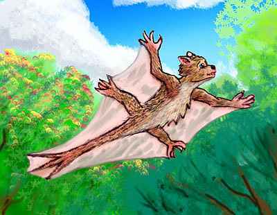
Omnivores, witweets eat bugs, seeds, fruits and leafbuds in the rainforest canopy. Like most other canopy-dwelling peoples, early on they discovered the benefits of tending and selecting their trees; today their forests look wild but in fact are haphazard orchards.
You find them polite, gentle, but distant hosts. Despite their big eyes, essential for navigation in dim forest, witweets live in their own world shaped mostly by scent and sound.
You sit at the edge of a crowded platform, listening to a short concert before you sleep. What you can hear of it is lovely, intricate, subtle, but so soft you miss half the passages. Witweet music is renowned but doesn't export well, because no one else can play it. And witweets don't play foreign music or study abroad, probably for a physical reason: this acute hearing, vital in the dense Trillian forest, makes them sensitive to loud or ugly noise. While they love their own music, they find most other races' vocalizations blaring and loud machinery intolerable. Cities and harbors are cacaphonous to a witweet. Noise-intolerance may be the real reason they travel so little and have spread so slowly.
Not that witweets will admit it. It's not shameful in witweet culture to dislike the sea; but for a witweet to admit finding other peoples sonically ugly would be a deep insult--and witweets are so passionately polite that the truth may never be known.
Next morning you fly up the cape for an hour and a half before reaching a low neck, barely five miles wide. The mainland beyond soon rises to true mountains: the Witweet Range, Trillia's spine. The Witweets average 2400 m high (8000'). Ferny alpine meadows around their summits are about the only open land on Trillia.
You chug steadily northeast all day, up the coast, and sleep due south of Mt Witweet in a coastal village of sphinxes. These immigrants to Trillia spread down the Lenidel Islands from the Gaiila Region a few centuries back.
You're glad they did. It may seem odd that polite teddybears intimidate you and big sharp-clawed cats don't, but you find you're far more relaxed around sphinxes. They're an easygoing people. Witweets' acute senses make you feel a bit like a crude alien monster, and their very politeness makes you uncertain--you worry that you smell bad or are being too loud. No such uncertainty with sphinxes! A little rudeness is a reassuring thing.
Next day you hug the coast again; inland the peaks rise into a dense, stubborn cloud cover, where you'd be flying blind. Around noon you reach Cape Lenidel, where the coast bends north.
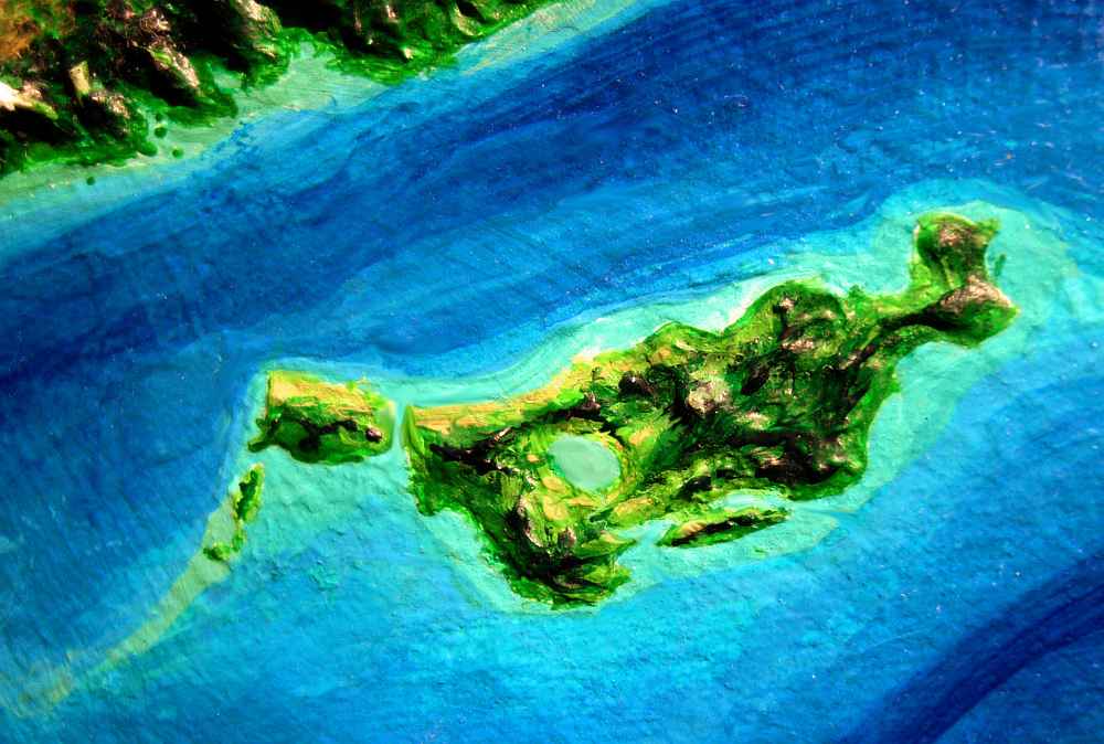
You decide to skip Lenidel Island a few hours offshore, though it's three times bigger than Crete. It's much like the mainland--rainforest covering steep, dissected ridges. Culturally, it's a bit different--witweets settled the island only a Lyran century ago. They only learned of it through the local sphinxes, who'd begun fishing its coasts and even planting a few orchards. Like having to learn of your own backyard from your neighbors! The witweets' ignorance of such a large land just over their horizon says much about their stay-at-home nature. Witweets did finally sail across in chartered boats sailed by soka, and only settled the inland hills, leaving the long coasts to the sphinxes who'd discovered and settled them. Sphinxes make up perhaps half the population.
Here on the mainland, the mountains start pulling back. You head inland, following a river valley that stays below the worst of the cloud cover. Near sunset, you reach a low pass, misty but with glimpses enough to bumble your way through... and then the clouds fray until the setting sun breaks through--a diadem of reds and purples and blue shadows. Ahead, a plain of molten gold blinds you: Lake Annanna, cupped between two spurs of the Witweets. The far shore's a dim silhouette; it stretches out of sight left and right, for almond-shaped Annanna is fully 170 km (110 mi) long.

You glide down to its red-lit shores and seek a crag or hilly cape. Yes, there's a headland with great falcon-shapes wheeling in the ruddy light: a sphinx village is cut into the bluff. They wheel round you in welcome and guide you in to the landing ledge.
On the terrace, your hosts pounce on you and lick you curiously... In exchange for some after-dinner ear-scratching, they warn you about the north. Scenic, but torrentially rainy this time of year! Nearer the equator, lower in altitude, it's hot and muggy, too.
Most visitors come to Trillia either to meet witweets or simply to pass through, for it's the shortest, easiest flyway in and out of Ak'hai'i, as well as the safest route to the Diomedes Region from Ythri, Oronesia, Gaiila and Flandry.
So for you, the only reason to slog north through the rain is if you're heading up the Trillian Chain to see the monsters on Carnoi and pass on through Gaiila.
The rest of you, follow me! Let's head south along the east coast--somewhat drier, though that's saying very little. It's showers and rainbows and well-meaning, distant, polite witweets all the way...
At least they're dry. Dry seems to be their only attitude, at least to great lumps like you.
From Cape Southwest, it's a five-hour flight back to Cape Ktiya on Ak'hai'i. This peninsula clad in sober, towering, redwood-like forest now seems sunny to you, after Trillia!
Ride the updrafts a few hours more, south along the face of the Gneiss Range, until you face the great keel of Mt Henge. Here you face a choice:
Hroai is a temperate land nearly the size of New Zealand's south island, 700 km long and 250 wide (450 by 150 mi). The north's a rugged maze of steep green canyons and ridges around Mt Ehin, the highest peak on Hroai at 2600 m (8500'). Ehin looks like the fluted stump of a huge black tree, with buttresses a thousand feet tall--it's the plug of a huge old volcano, badly eroded by the heavy rains of this latitude--while it's cooler than Hawaii, the lava and erosive forces are similar, which is why all north Hroai looks so much like the wet side of a Hawaiian island.
Past the summit of Ehin, we enter a slight rainshadow. The south's a lower, drier, gentler basin of open woods and meadows. Ahead of you, in the heart of this basin, is a silver sheet: Lake Uo, an oval 110 km long (70 mi). Most of southern Hroai drains into Uo. We'll follow the shore round to the left. At the east end of the lake is its outlet; we follow the winding Uo River down to the sea. It's already on the horizon--Hroai is not that wide.
The east coast (note that the orbital photo to the left is tilted; north is to the upper right) has two great natural harbors behind a T-shaped peninsula. They remind you of San Francisco Bay--except the sea's to the east, the water's clean, and the cities are hidden in the trees. We drift south, then west when the coast turns, riding the updrafts along the sea cliffs and coastal hills.
A channel suddenly opens in the hills. Not a bay this time--deep blue ocean to the northwest. The end of Hroai! The hills beyond belong to Lyang, a gentler, drier island 200 by 100 km (125 by 60 mi). The hills are covered in open woods, with a Mediterranean look, but cooler.

A couple of hours along Lyang's south shore, and we reach a point and a string of islets pointing due south--the jumping-off point for the southern Ak'hai'i lands. Here we camp and rest, for it's a nine- or ten-hour flight to Prasiyo. And another climate zone--we're heading straight for the pole. Bring a warm coat--or, like the icari who've settled it, grow one.
You set out into a cool hazy sky over steely gray sea...

TOUR LYR! Climb volcanoes, swim seas, meet weird creatures. First: survival tips! Then, pick a region:
Ythri -- Polesotechnic Chain -- Troisleons -- Roland -- Oronesia -- Gaiila -- Flandry -- Diomedes -- Ak'hai'i -- Averorn
World Dream Bank homepage - Art gallery - New stuff - Introductory sampler, best dreams, best art - On dreamwork - Books
Indexes: Subject - Author - Date - Names - Places - Art media/styles
Titles: A - B - C - D - E - F - G - H - IJ - KL - M - NO - PQ - R - Sa-Sk - Sl-Sz - T - UV - WXYZ
Email: wdreamb@yahoo.com - Catalog of art, books, CDs - Behind the Curtain: FAQs, bio, site map - Kindred sites