
Prasiyo, Ya-Kela, and Valland
by Chris Wayan, 2006
dedicated to Poul Anderson for his remarkable world-building
Lyr (home) - map - creatures - cultures - evolution - climate - geology - gazetteer - nomenclature - definitions - building Lyr - more worlds? Planetocopia!
INTRODUCTION
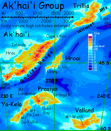
The Ak'hai'i Group is a huge, lonely cluster in the Southern Hemisphere, 6000 km southeast of Diomedes. The six major lands are Ak'hai'i, Trillia, Hroai, Ya-Kela, Prasiyo, and Valland, totaling 3.1 million sq km (1.2 M sq mi, the size of Western Europe). Ak'hai'i proper is nearly as big as the other five together. The region's cool to temperate, with gentler terrain than much of Lyr. The only flyways are from the Rorvan Is. to the west and Carnoi to the north, plus a passage to even colder and lonelier Averorn to the south.
This tour explores the south--Prasiyo, Ya-Kela and Valland. Be warned: most of this land's close to the Antarctic Circle. So bring a warm coat--or, like the icari who've settled it, grow one.
You land on the north shore of Prasiyo, a cool-temperate 1200 km long (750 mi), twice as big as New Zealand's south island, with few trees and wide grassy steppes. The low, marshy Urduga Basin takes up most of the east; the west end is a lava plateau dominated by Mt Landomar. Prasiyo has a twin just to the west, Ya-Kela, across Eltokh Sound. The third in the group, Valland, is more distant--and colder. The trio's area is 900,000 sq km (360,000 sq mi), bigger than New Guinea; but what they resemble most is Patagonia! The climate's cool and dry for Lyr, with wide steppes and even near-deserts.
The coastal plain is green enough, with open woods and meadows; but as you fly inland to the southwest, the groves thin to open prairie. Slowly the hills rise into a low, sparsely wooded range. You crest the final ridge and a pale-blue sheet lies beneath you--Lake Silence, the largest on Prasiyo, 80 km (50 mi) across. The basin is grassy and rolling, though trees line the lakeshore and streambeds. The shore is dotted with icarus villages, some in trees around creek-mouths, some carved into cliff-faces of bluffs bordering the lake. You dive down the long slope and follow the arc of the lakeshore west. The afternoon sun glares in your eyes, reflected in the lake; when you reach a great point and find another arm of the lake beyond, now a sea of orange glare, you decide to quit early for the day, and ask shelter on an icarus eyrie on a small island at the tip.
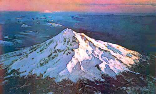
Next morning, in the low, red dawn, the whole western lobe of the lake glows a pale soft blue--broken by the flaming reflection of a broad-shouldered, snowy peak on the far shore: Mt Landomar, a shield volcano 3800 m high (12,500'). The truth is, you're already on Landomar's knees, or maybe lap--it's nearly 400 km (250 mi) wide at the base, and its lava flows curl around Lake Silence and Shkil Bay; this point is an old lava flow. You head for the peak, rising slowly from prairie into woods. Well before noon you swing past its northern flank. The northwest face of the mountain is near-desert, gashed by canyons where snowmelt runs down from the heights. These mesas and cliffs look like ideal habitat for floxes, pegasi and antel, but they haven't spread this far south. Why are these lands so empty, with only an occasional icarus eyrie carved into a canyon wall? Simply that Lyr is so big. Prasiyo is thousands of km beyond the other three species' ranges. News of these prairies and canyons may barely have even reached their ears.
You follow a canyon down to the sea. The delta's irrigated--icari again. You stay in a farming/fishing eyrie, looking out from a cliffwall over the orchards to a cove. It's a pleasant spot, but the land feels lonely, with just one species of people. Now that Lyr's other regions have shown you the opposite, it's a loneliness you fear you'll sense for the rest of your life, back home on Earth.

YA-KELA
Midway across Eltokh Strait, you realize the "island" you were aiming to rest on is really the tip of a long, narrow, rocky finger: Cape Azkashi, northeastern tip of Ya-Kela. Like a highway through the sea! You ride the updrafts over its coastal bluffs west another hour to the Ya-Kela mainland.
This near-twin to Prasiyo is 1200 km long and only 250 wide (750 by 160 mi), about the size of Britain--though it looks more like Alberta, with mountains rising from a sea of dry grass.
You spot a dramatic eyrie honeycombing a sea-stack, and ask to stay the night. It's a bit early, but you're worried you may find no shelter inland at all--no people. And you're nearly right. The next morning, you fly southwest over the broadening land, as the groves of the coastal strip fade into prairie. Around noon you pass your last icarus eyrie. You cross a low divide into the broad valley of the Azkashi River, 340 km (210 mi) long, draining most of northern Ya-Kela. The river bottom is wide, the river shallow and braided. You follow it inland. Slowly the trees along its shifting shores, and clinging to its islands and sandbars, creep up the valley slopes. These sharpen into ridges, increasingly dotted with scruffy "pines". Behind them, over the left bank, you start seeing a far white wall. A mountain range? Not quite.
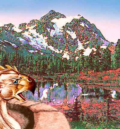
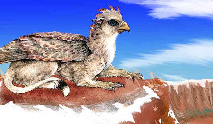
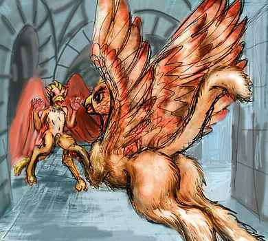
What you're approaching is a single, broad shield volcano like Landomar: Mt Su-Iss, 3400 m (11,200') high, with shoulders miles wide--a country, not a peak. You head up a side valley, straight up the gentle but relentless slope. As you enter the highlands, great shapes wheel above you, too big for icari, calling a hoarse greeting in hawk-voices: gryphons. They herd their placid wingsheep on these slopes, amid "pine" groves and alpine meadows.
The gryphons escort you to their hold, a stone castle on a rise. Sore-shouldered and tired from the climb; you're glad for a break. But those who haven't met gryphons yet should be warned: they're messy, bloody eaters. If you're at all squeamish, I'd avoid the lunch room--a whole pride of winged, hawk-headed lions dismembering a wingsheep can be a bit much. Just accept a snack of fruit and wingsheep cheese and eat on the flight-terrace.
Here a young gryphon offers to show you the caldera. It's on your way, so you say yes. It's a hard climb--the wind's with you, but you're short of breath. Why do you feel faint? It's thin for Lyr, yes, but the oxygen level is quite Terran--in the lowlands, the air is supercharged--indeed, stressful on your lungs, longterm. And in fact that's the problem. You've spent weeks adapting to over-rich air, and by now your blood is thin. If you've scratched yourself, you must have noticed you bled a pale, watery orange. Less hemoglobin. Not to worry--this severe anemia is just your body protecting itself from overoxidation. Of course when you're ready to leave Lyr, it might be wise to come stay in a hillside gryphon-keep for a few days while your blood turns red again...
You glide groggily up to the rim, skimming just above the rocks and snowfields, to take advantage of the ground effect (a bubble of higher pressure between you and the ground). But this has its risks. The edge surprises you, and you nearly go over. Collapsing in a tired heap on the brink, you gawk at Su-Iss Caldera, a mile below--and nearly twenty wide. Cliffs cup a cindery waste like a round terrarium... though it looks so pocked and cratered, "lunarium" would be a better word. As stark as the moon! The great wall's breached on the far side; a second, distant, hazy white peak floats above the gap: Su-Iss's steeper sister, Su-Kulka, 3200 m (10,600') high.
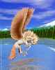
A heraldic monster lands heavily beside you on a boulder wind-scoured clear of snow. You feel a flash of alarm, for her crest is up--a sign of battle-challenge. But her tail is sweeping the snow with excitement, and you recall a raised crest can just signify an overwhelming emotion, like a human moved to tears.
"Isn't it beautiful?" she purrs. And it is... but so stark! The lunar desert, the Martian cliffs, the Alpine outer slopes... suddenly your perspective shifts, and rather than a gryphon in its natural landscape you're seeing an isolated girl, an artistic soul among practical pioneers, finding what consolation she can in loving an unloving land, eager to share with someone who understands, ready to look beyond the barrier of species. But she's trapped on a mountaintop in a species-deprived land! Elsewhere on Lyr, she'd have the opportunity to find a mixed town, full of other, less stark beauties. Other minds, other arts, other cultures. Here, all she has is you.
"I've considered it" she says. "I hear Tauno and Yria, over in northern Averorn, are like that. They're the only place I could reach, I guess." She means without fatal overheating--the equatorial zone might as well be a sea of fire to a gryphon. You feel uncomfortable urging her to follow her heart, for it's a good 15,000 km (over 9000 mi) to Yria through the stormy Averorn chain. But you do it--for sooner or later, however risky, you can see she'll have to go. There is, after all, a precedent; her ancestors came from Tauno, and from the northern hemisphere before that--despite casualties, they did achieve the impossible, and she knows it, for every gryphon chick in the south is practically raised on the Epic of Hrill...
You give her a note to the tiny Terran Consulate, recommending her as a foreign exchange student, and add your address on Earth. It's wildly unlikely a winged hawk-headed lioness will ever scratch at your door, but of all the people (and peoples) you've met, this is the first you've suspected may end up like you--on an alien world, relying on the kindness of strangers. However unlikely, you have to honor her dreams--and the fierce provincial passion that may drive her to realize them.
Her name is Eyath, "Third Star" in Trade; but in this antipodal wilderness that name is bizarre. For Eyath is the most cosmopolitan island of Oronesia, cultural capital of the world, where nearly every intelligent species on the planet (including gryphons) has at least a small community. Hearing that name here is like sledding deep into Siberia's mountains, and in a hut of bones by a frozen stream, meeting a woman who calls herself "Hollywood"--or maybe "Oz". For Eyath the island, Eyath the promised land, is about as reachable as Oz: nearly 45,000 kilometers by the shortest possible route, through equatorial heat that Eyath (the girl, not the island) could not long survive. Yria is her only hope; where true deep-sea ships come to port, ships that might take her on as special cargo and arrange the same elaborate trick her ancestors used. Eyath will pluck her own great wings and insulating down like a neurotic parrot, and crouch shivering in a tub of cold seawater for weeks as she crosses the line. She might die of it; but it's the only way, short of a starship, for Eyath to reach her heart's desire: her real home. Lyr may seem no more to you than a furry Oz, but it isn't. No hope of ruby slippers. The only way out's through pain.
But Eyath can't slash her ties to clan and keep with one claw-swipe. It'll take at least a season or two--and they're much longer here than on Earth. You can't wait; you must tour the Prasiyos now, in high summer, or not at all. That gryphondown, letting her sprawl comfortably in this snowfield while you shiver in the wind, also lets her travel here in winter. Not you! The thermal barrier works both ways--she may feel caged, but you're forced to leave.
She blinks and tilts her great head, thrusting it forward. You know the gesture only from guidebooks, but it's no different than any Terran cat; you rub cheeks with her, an intimacy she's likely only allowed with parents, siblings and lovers until now. You feel honored--and moved to match the gesture with a grand one of your own. You'd planned to skirt the rim, playing it safe--but on impulse you turn to the cliff and jump.
Down you dive through icy whistling air until it warms around you. Leveling off, you skim the cindercone desert toward the great stone gate, and past its kilometer-high buttresses where pines cling to ledges, like the mouth of Yosemite. Your mood shifts from melancholy to exaltation. Back on the wing! What could be finer?
On the horizon, Su-Kulka beckons.
But before you lies the Su-Kulka Desert, seamed with canyons where short snowmelt rivers descend to the sea. It's much like the desert downwind of Landomar--anywhere else on Lyr, pegasi orchards or the spiral beanfields of floxes would cover these bottomlands, but neither species has made it this far south; the only inhabitants are icari tending small orchards and fishing the few lakes, and occasional gryphon clans on the peaks, herding flocks in the sparse grasslands. Gryphons contented with their land and lot--at least at this distance. What would a closer look reveal?
You could go further west; Ya-Kela is big. The Roli River, 270 km long (170 mi) drains most of southwestern Ya-Kela, and Cape Roli stretches a further 180 km west of the rivermouth; but it's all dry prairie right to the sea. Let's skip it--west Ya-Kela is a dead end, with only pioneering icari. Eyath, that gryphon girl, has infected you with her longing. East! It's a long haul back to multispecies civilization, through even lonelier lands--but you have to start sometime. Sometime before winter!
So you veer southeast, down into another Ya-Kela entirely--the windward side. This coast is green, for what storms there are in this belt pile up against the mountains and wring themselves dry. Icarus-tended orchards flourish in every valley. It reminds you faintly of Japan, though with the hulking shoulder of the Su-Iss caldera looming inland instead of the lean cone of Fuji, black outlined in shocking pink, against Lyr's ruby sunset. The next morning, you fly leisurely up this pleasant country all day, sleeping in a little cliff village on the shore of Eltokh Sound again. The people seem gentle and kind and human, after the gryphons; but you miss that passion, even that loneliness. Will you adjust well, back on crowded little Earth? (Oh, wait; if you've come this far with me, you probably weren't too well adjusted to the old monkeyhouse to start with.)
You strap on your wings without a word and take a running leap off the breakfast-terrace and head out to sea. It's quite safe: Eltokh Sound is speckled with green islets here. Your longest hop is little more than an hour. By evening you land again on the southwest shore of Prasiyo.
SOUTH AND EAST PRASIYO
Your landing-place is nearly as fertile as windward Ya-Kela--drier perhaps, but with rich soil: for this whole coast is an overlapping tangle of lava flows from Mt Landomar. Icarus orchards fill the bottomlands and send colorful streaks up the hillsides, marking creeks for miles. Their trees are bred to have red, gold, blue, plum and near-black leaves, not for better yields, but just because icari like color. They don't go so far as to form pictures like the tropical antel, but it still contrasts with the stark practicality of most human farms.
You fly east, slowly passing Landomar, which rises much nearer the coast here; as much a presence in this land as Su-Iss was on eastern Ya-Kela. By sunset it flames behind you. The next morning, the coast continues a bit south of east, but our path angles inland, up a modest river and over a low pass. A lesser volcano stands to the southeast, forming Cape Landomar.
Over the divide gleams the sheltered water of Shkil Bay, 300 km (190 mi) across. Cape Landomar runs nearly out to the horizon; you can't see Shkil Island 100 km beyond. Shkil is 110 km long (70 mi), further sheltering the bay's mouth; it's nearly an inland sea, shallow and warm for this latitude. We could use Shkil Cape and Island to hop across the bay's mouth--the flyway's a bit shorter--but let's skirt the bay's shore instead. "Oak" groves on eastern hill-slopes, golden grass on western slopes, with green veins where streams descend from Landomar--the land looks quite Terran--rather Mediterranean. By noon it's actually hot, and you land on a beach and risk a swim. Pretty mild water for 56 degrees south--on Earth, that'd put you on Cape Horn, not far from Antarctica. It sure shows how much milder Lyr's poles are than Earth's. A glance at the world map tells you why: no great landmasses to glaciate.
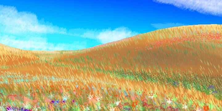
A bit past noon you reach the Urduga Delta at the bay's north end. The Urduga River's the longest on Prasiyo. You've already met. The western Urduga rises on Mt Landomar and rushes down to pool in Lake Silence, then flows east to meet the other branch, the Enver, a more placid, many-branched stream--our flyway, now. Neither branch of the river's over 400 km long, but the Urduga Basin is 800 km wide, draining most of Prasiyo (badly: marshes surround the sluggish, winding rivers). Further from the rivers, where the land rises even a few meters, the western part of the basin's grassland with few trees. The marshes and prairies feel wild and lonely--crying out for pegasi to graze them. But the nearest village of that northern people is 20,000 km away. In their place, only nonsapient little antelopes graze in small bands. At least they graze until you pass overhead--then wings unfurl in panic and they flock aloft, fleeing this huge, unnatural predator--you in your strap-on wings.
Slowly the land grows lusher, and solitary trees appear; as we fly east up the Enver, into low hills near sunset, they fuse into groves. For the first time in weeks, you can't find even an outpost of icari or gryphons. You camp alone, in a grove of low trees that look like oaks but smell like licorice.

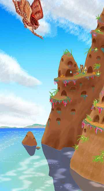
In the morning you crest the hills and find a green coastal strip 70 km wide: Cape Enver, the eastern tip of Prasiyo. Patches of color in the woods mark flowering icarus orchards around occasional villages. You head right out to Enver Head... and keep going, to the little islet of Enver, only 5 km long (3 miles). Here, in a fishing eyrie on the eastern cliffs, you call it a day, and rest and socialize.
Your hosts are glad to have a stranger--though all traffic between the Averorn Region and the rest of Lyr must pass through here, that's still not many people day to day. One of the adolescents keeps a species count; in her lifetime, only five of Lyr's seventeen known intelligent species have passed through. You're number six--the first offworlder she's met. This isolation may sound familiar to Terrans who've visited out-of-the-way places like Pitcairn, Kerguelen, or South Georgia. But on a wingworld like Lyr, it feels eerie and sad. Yet unlike that gryphon girl on the crest of Su-Iss, these icari aren't prisoners of their biology; they're certainly of a cold-adapted subspecies, short and stocky and fluffier than the sleek icari of warmer Gaiila or even Ak'hai'i to the north. But they wouldn't die of heatstroke. All that isolates them is sheer distance! 10,000 km of cold sea...
You sing together that night. Even the music here sounds lonely. With only two species singing (and one of them just you) the voices lie in such a narrow range! What a contrast to the communal sings in the music-inns of the north!
You're eager to leave in the morning, but the locals suggest waiting an hour or two, til the sun climbs out of your eyes. So you talk of your travels until mid-morning on a stone terrace above the cold sea, then set out on the six-hour flight to Bren Island, off Valland's western tip....
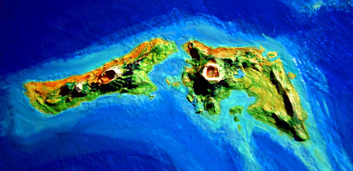
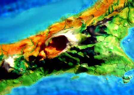
The first land you see is Bren Island--I hope! The flight east from Prasiyo is safe enough if you spot Bren--you can rest, eat and sleep before heading on to the mainland. It's just a few hours of easy islet-hops from Bren. But if you miss Bren (and it's only 25 km long (15 mi) in a vast sea known for fogbanks and whimsical winds) the flight to Valland becomes a grueling nine or ten-hour nonstop flight. If you find Valland at all! Cape Bren is low and narrow, too.
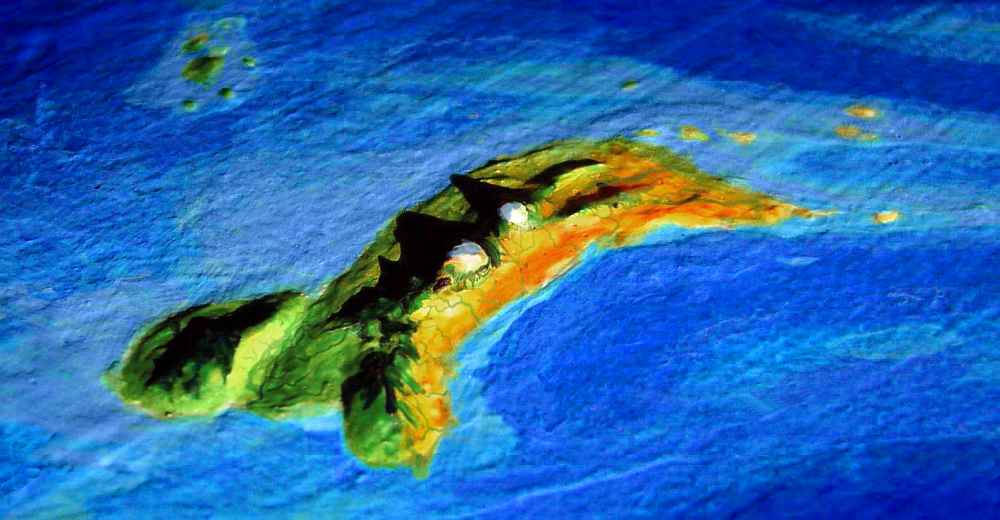
In the orbital photo above, taken late one winter afternoon, south is at the top; dry Cape Bren is on the right, and the green knob of the Yo Rork Peninsula is on the left--it's all upside down, compared to the map.
Valland's narrow at first. The Bren coast is a wedge of cool windy grassland... slowly widening to rival Nebraska! This end of Valland is big-sky country--rolling prairie, with trees only along sheltered rivercourses.
No. Not hawks. Far larger. They're gryphons, who've settled this patch of cool upland in the grass sea the way humans settle and fish from an island. The prairie's a bit warm for them, but they herd and hunt the hills.
Even Smeth's mountain-shoulders lack dense forests. You soar over alpine meadows, rocky ridges with scattered "pines"; only sheltered valleys have real woods. The air is dry and piny; it feels like Colorado or Utah. There's a reason for the aridity. Mt Wenli to the east, even taller than Smeth, intercepts most storms. You can see the thief now, a white tooth on the eastern horizon.
You head east across the open "ponderosa" saddle between the two great peaks. An hour or two later, Mt Wenli looms above you--the highest peak on Valland, at 3300 m (10,900'). It too looks bare, and you wonder if another range lies beyond, stealing rain from the rain-thief. But as you circle the mountain's flank, the trees draw closer and grow higher, until the east slope of Wenli has true forest. You've reached the wet side of Valland. Richer land! Alpine lakes dot the valleys like sapphires; wherever there's pasture, stone gryphon-keeps rise on nearby crags.
You stay in one as a guest. It's strange at first after living among only icari so long. Despite yourself, you feel shy. Such big sharp beaks, such big sharp claws...
And that duel before dinner over who gets to sit by you doesn't help.
Still, you'd better get used to it. Further southeast, you'll either stay in gryphon-keeps, or freeze...
But not today. Today's easy. You swoop out of Wenli's highlands into pleasant-looking hills, a patchwork of meadows and groves: the upper Arwy Basin. The longest river on Valland, the Arwy runs 480 km (300 mi) west to the sea. It's about as rainy as Valland gets, with scattered groves inland melding to a strip of coastal forest. It's all icarus country, with watercolor-streaks of plum, white, gold marking their contoured orchards in the dark green of the wildwoods. Well, semi-wild. Many of those trees, too, are domesticated for both seed- and wood-production.
You follow the Arwy down. It's a slow glide, for there's a steady headwind--the prevailing winds here come from the east. But you're in no hurry and the hills create regular updrafts; you spiral up then glide down the river until it's time to gain altitude again. An easy day. Toward sunset you reach a marshy lowland: the base of the Yo Rork Peninsula.
The eastern tip of Valland, Yo Rork is a hilly oval 150-200 km wide (90-125 mi). It's a green ecological island, getting nearly twice as much rain as the mainland. Only this long marshy trough links its forested hills to Valland's prairies.
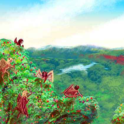
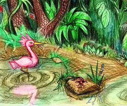
We came here for practical reasons, not just to look at Yo Rork's dozens of odd endemic species. I admit it's crass and unscientific of me, discussing only intelligent species all this time. Is there a word like sentism, bias in favor of sentient beings? Yo Rork has toothed flamingos, and red komodo dragons, and fern trees, and even a shy nocturnal marsupial that may one day achieve civilization... all of them well worth an extended stay, camping and sketching. But do I slow down and sniff the flowers? Nah.
Why? Because this is one of those shallow, commercial tours, like those "Europe in Seven Days" packages. And before you complain, let me remind you it's a free tour of one billion square miles of planetary surface. Not million, BILLION. Five Earths! You try doing that in your spare time...
So a peninsula nearly as big as Wales gets three paragraphs. Sigh...
On the map, it looks like you've reached a dead end. But that family of icari heading due south into the gray sea says otherwise! No, don't follow them yet. The flyway they're setting out on isn't that hard, hop by hop, but they're heading nearly straight for the pole. Make sure you have food, and warm, waterproof gear. We're headed for Averorn, the last land on Lyr to be settled--understandably. It's the last place I'd want to settle too.
Still, Averorn's scenic. And it's high summer--you'll live. Just bundle up.
I'd recommend electric underwear, but it'd just short out in the rain.

TOUR LYR! Climb volcanoes, swim seas, meet weird creatures. First: survival tips! Then, pick a region:
Ythri -- Polesotechnic Chain -- Troisleons -- Roland -- Oronesia -- Gaiila -- Flandry -- Diomedes -- Ak'hai'i -- Averorn
World Dream Bank homepage - Art gallery - New stuff - Introductory sampler, best dreams, best art - On dreamwork - Books
Indexes: Subject - Author - Date - Names - Places - Art media/styles
Titles: A - B - C - D - E - F - G - H - IJ - KL - M - NO - PQ - R - Sa-Sk - Sl-Sz - T - UV - WXYZ
Email: wdreamb@yahoo.com - Catalog of art, books, CDs - Behind the Curtain: FAQs, bio, site map - Kindred sites