
AVERORN
by Chris Wayan, 2006
dedicated to Poul Anderson for his remarkable world-building
Lyr (home) - map - creatures - cultures - evolution - climate - geology - gazetteer - nomenclature - definitions - building Lyr - more worlds? Planetocopia!
 INTRODUCTION
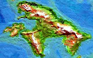
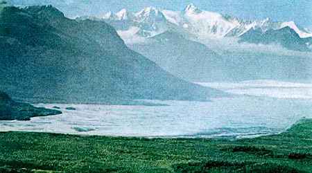
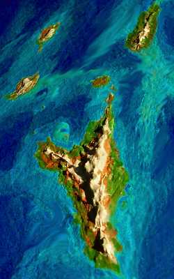
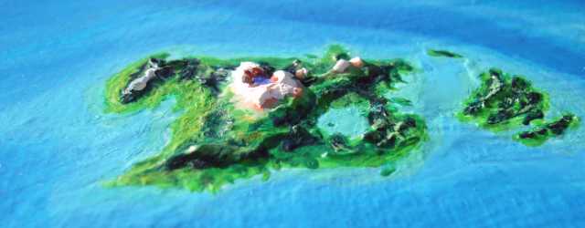
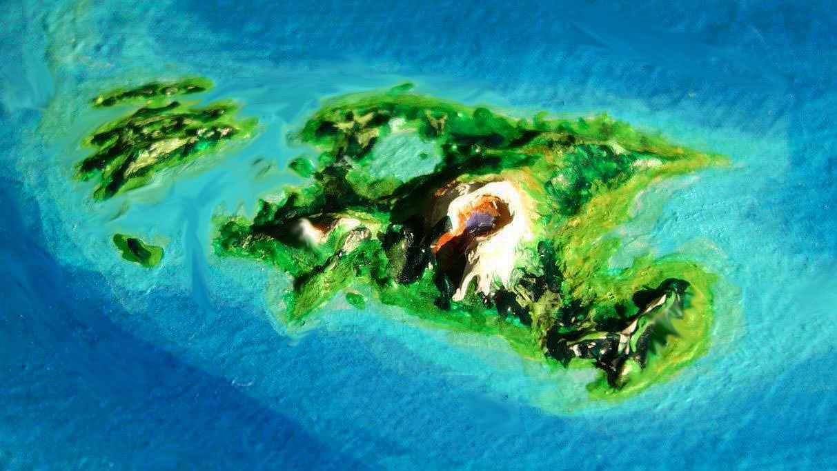
Averorn is a vast chilly archipelago in the Antarctic Sea, rivaling the Canadian Arctic islands, but far more scattered--sprawling over nearly 8000 km (5000 mi). Tauno and Eyjan are each twice the size of Britain. Four more, Bengta, Vanimen, Kennin, and Yria, are each half that size--larger than Newfoundland.
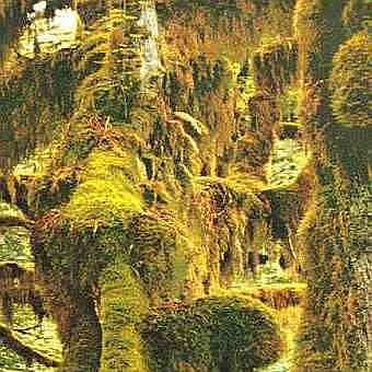
However, only Yria and Tauno are really fertile, lying far enough north to have wide boreal forests, ice-free steppes and tundra. The others are polar, with glaciers and arctic steppes above cold rainy lowlands unlike anything on Earth, full of bogs and low "sleetwoods"--something like the bizarre, mossy, subarctic rainforests of Patagonian Chile or the Queen Charlotte Islands near the Alaskan Panhandle. Low, slow-growing, twisted, moss-bearded, dense, a lurid green, looking profoundly alien, they survive because much of the Averorn Group is in a polar rainbelt, a wide band of this strange climate existing only in a few spots on Earth (see Climate Belts).
But to be fair, Lyr has only tiny scraps of one of Earth's polar climates, too: icecaps like Antarctica and Greenland. Lyr's dense air traps heat more effectively than Earth's; Averorn, like Antarctica in the Age of Dinosaurs, is cold but habitable even in the depths of winter darkness, and summers melt accumulated ice. Only one small island, Atitak, is ice-covered, and altitude's as much to blame as latitude.
THE EYJAN GROUP
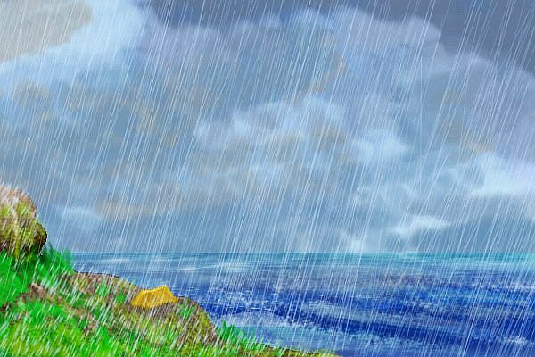
We'll enter the Averorns via the Niels Islands, a chain 1300 km long between cool-temperate Valland in the Ak'hai'i Group and Cape Niels on Eyjan. None of the Niels is over 80 km (50 mi) across, but they're the only flyway into Averorn. The isles look Alaskan; the uplands are cold steppes--not true tundra, since Lyr's had no recent Ice Age and lacks deep permafrost, but cold stony alps that pass for tundra to a casual eye. Stunted forests and bogs fill the lowlands. Strangely, the forests grow as we hop south, and the weather's wetter--constant rain, mist and drizzle. Welcome to the sleetwood belt!
The Niels chain leads to Eyjan, second biggest of the Averorns, 1200 km long (750 mi)--as big as Baffin Island, bigger than Britain. Glaciers cap the low mountains, but the blizzards give way to endless cold rain and sleet storms in the lowlands, feeding bogs and sleetwood on the lower hillslopes--all the way to the polar shore, at 73 degrees south!
We land on Cape Niels, a rough triangle 450 km on a side (280 mi). The uplands are cold steppes, the lowlands are solid sleetwood--tangled, impassible moss-green mazes. Averorn's as big as Indonesia, and its dense sleetwood gives it a large biomass, but the population's as low as the species count, and most keeps are along the warmer north coast.
I could lead you that way--shorter, easier, friendlier, it's the traditional flyway--but sheltered by the mountains and facing the sun, it's something of an oasis, with a tenth the area of Eyjan and half the population. Southern Alaska! But I want to give you a sense of Averorn as a whole, and South Eyjan is far more typical.
So, south along the shore of Niels Bay; our best path (of a chilly, bad lot); it's not that much colder than the north shore of Eyjan, but the icy ridges north and south of the bay block most of the rain, reducing cold boggy sleetwood to merely Alaskan forest.
Still, you dodge curtains of rain all day to reach the south shore of Niels Bay. Hills to the northwest, out to sea, mark Als Island, an L shape 240 km across (150 mi); a narrow sound divides it from Cape Als, the long strand beneath you. Follow the sound--below the cliffs are shoreline strips of low, livid green mossy trees.
There's nowhere to camp in that treacherous thicket, and around sunset you're getting nervous. Camp on a windy cliff-ledge and hope you don't get blown off in the night? Even the ledges are tanglewood. The strait seems to be coming to a dead end ahead, too.
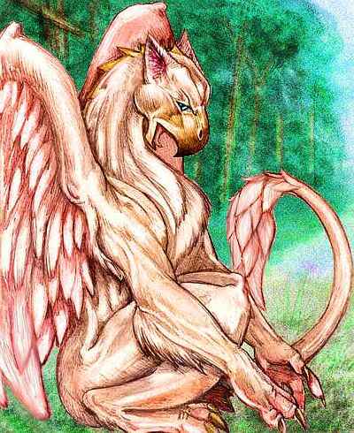
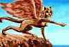
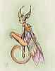
But there's a sort of castle halfway up a cliff. A gryphon keep!
It's like finding a Swiss chalet in Antarctica.
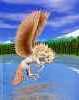
You land and the gryphons make you welcome indeed--they've had no visitors for a long while. You ignore the occasional spatter of blood in your eye at dinner, as your hosts tenderly dismember the dead marmots. You'd be messy too if you had a beak instead of lips! You're too tired to care. You're just grateful to be warm and dry and safe.
Well, fairly safe. The adolescents all flirt with you, desperate for someone outside the clan to mate with. Even a crazy alien like you looks good. They're eager to experiment, if you are. Just remember those sharp beaks and claws!
In the morning you're either well-rested or sleepy and scratched and sore but pleased with yourself, or very scratched and sore and regretting the whole trip. I'm not going to pry. No matter what your night was like, it's day now. Time to head on west.
Within a few miles, the head of the sound--an apparent dead end--turns out to be an illusion. It bends sharply south and opens to the sea again. Before you is a long, straight shore exposed to battering winds and waves. The sleetwood dwarfs down to scrub, and retreats to the lower hills. The low mountains are ice-capped, but the glaciers don't reach the sea; instead, steppes cover the middle slopes--stony, cold, wind-blasted grasslands. For hours we ride the harsh winds south, further into the cold, to the southern tip of Cape Als.
That faint shadow on the southern horizon is Minik, 200 km across (130 mi). Too low for glaciers, the uplands are cold steppes and the lowlands dwarf sleetwood where there's wind-shelter, mainly on the northeast coast. It's just a satellite of much larger Bengta, 500 km long (300 mi--bigger than Newfoundland). Glaciers do cap Bengta's low mountains, but the blizzards give way to endless cold rain and sleet storms in the lowlands, creating bogs, tundra, and, incredibly, STILL some mosswoods in sheltered valleys, even on the south shore--14 degrees from the pole! That's like forests in northern Greenland. Puts the miserable weather here in more perspective, yes? This isn't a cool-temperate zone like Scandinavia--the fairest comparison would be the shores of Antarctica.
Still, Bengta may not be as cold and miserable as the Antarctic Peninsula, but it has its own soggy, drippy, sleety style of creating misery. Are you a tourist or a masochist? Let's not go and say we did. It's what the locals do--even gryphons won't live on Bengta, though they hunt there in late summer if there's a sunny stretch of days. A big if on Bengta.
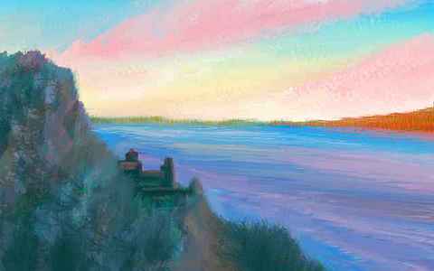
The main flyway heads north and east instead, around Als Bay, the southern shore of Eyjan. It's grim enough--on the sheltered bay shore, the sleetwoods grow thick, over 5 meters high, thick and twisted, as green-furred as a sloth, and quite unlandable. You're forced up into the hills or down to the beaches when you need a rest. And you do--cold and wet the whole time. You spot a second gryphon keep, and stop for lunch... Ignore the blood. Ignore the blood. You're just tired. Ignore the blood...
It takes all day to skirt the bay to the east end of Eyjan: Cape Hlesey. Here the mountains aren't low at all--jagged teeth, gnawed by the long glacier-tongues reaching toward the bay. But they stop in grubby moraines half a km above water. Even here, icebergs don't calve into the sea. You sleep in your third gryphon keep. You've probably met half the clans in southern Eyjan--territories here have to be huge, so keeps are over 100 km apart.
And this isn't the worst of Averorn. Not even Bengta is. Four hours' flight east of Bengta is Atitak, a steep volcanic isle three km tall, plumed with steam, ice-mantled to its knees, stony-shored. The cold dry winds dropping off the ice kill even sleetwood. It's the second-southernmost land on Lyr, after "Antarctica", and it's nearly as dead. This isn't so much latitude as altitude; Mt Atitak's heights act as a seed for glaciation. Had the volcano risen on Bengta, it would have suffered the same fate.
"On the other wing," your hosts might point out, "we aren't explorers, like your folk. Boats bring us no food or fuel. Our meat grew here; sleetwood feeds our hearthfire. The ash feeds the land. When our wings fail us, so do we. This is home."
My point's not that gryphons are noble; that's not genes or culture talking. That's climate talking! These polar lands are warmer and wetter than Terran subpolar land...
...at least as I write this, in 2008. In our warming Arctic, the treeline gallops north. Miles a year! I may not live to see Averorn on Earth; but I can see beyond my beak.
CENTRAL AND EAST AVERORN
East over shallow sea, turquoise with glacial silt. Not even steely arctic gray, for it's a rare sunny day. An hour and you reach Vanimen. A definite improvement! It's a good 900 km long (560 mi), the size of New Zealand's South Island. From afar its glacier-capped mountains look Alaskan, but the lowlands turn out to be as wet as Eyjan's. Bogs and sleetwood fill the valleys and flats, even on the polar shore at 72 degrees south. Though the woods are green, they're nearly uninhabitable for animal life--treacherous footing and slow-growing, nutrient-poor foliage. Only the stony slopes and steppes have grazers: thick-furred burrowers like marmots. With stubby wings. Yep. Gryphon lunch!
You don't lack for shelter here, for the northern shore is relatively warm and fertile, and supports a whole string of more prosperous keeps. Vanimen's high central ridge blocks the worst polar storms, and in this sunnier climate, they can fish more often and even garden; marmot's still the staple, but they get some variety. As a guest, you get "spruce" conelets (tiny magenta "pinecones", chewy and resinous, but edible), and a mustardy "cabbage", and raw "salmon". Not quite as elegant as sushi, but at least it's not bloody marmot. You're in tropical heaven.
You take two leisurely days to fly the length of Vanimen. At the east end, you veer to the unsettled (and unsettling) south shore. It takes an hour to find a ledge out of the wind that's not bog-forest, where you can camp the night before crossing to Meiiva, two or three hours southeast.
No illusion. You are. Lyr spins twice as fast as Earth, and its light materials and warm, more fluid interior let its equator bulge more; Lyr's nearly as oval as Saturn or Jupiter. You're closer to the center of mass near the poles, and there's less centrifugal force to lighten you. On Earth you weigh less than a kilo extra at the poles; but on Lyr the gravity creeps up from 1.23 G at the equator to about 1.4 in polar Averorn. You sag in the air like a plane dragged down by ice building up on its wings--but this weight can't be shaken off. It's in your bones.
And so, cold and shaking and exhausted, you nearly cry in disappointment when after six long hours your only reward is a dreary little islet past 73 south! Brr. But I promise that's the flyway's southernmost point. Cheer up! Tomorrow we turn north. We'll skip the Kennin Islands and Liri, easternmost of the Averorns. Kennin is impressive, 850 km long (530 mi), with a quite spectacular ice-capped spine of jagged 2500-meter (8000') peaks--like Earth's South Georgia Island writ large. But Kennin's as bad as Vanimen or Eyjan for icy fogs and endless drizzle. Wretched for warm-blooded beasts like me. Call me a polar wuss--I can't do it just to be thorough.
NORTHERN AVERORN
North! North at last, to Tauno! Northeast, anyway. Just a couple of hours at first, to another islet where you sleep the rest of the day and all night (well, that's only ten hours--remember how fast Lyr spins), resting up for the long flight tomorrow to Averorn's nearest thing to a continent--huge, warm, fertile Tauno.
You fly all next day and night, some 13 hours. Luckily the sun never drops far below the horizon here, even now in fall (I've timed this tour to avoid the summer bug season. Yep! Sleet, fog, endless night, extra weight and stinging flies--it's nonstop fun in the Averorns.) You can still see quite well, flying by night. It's cold, but clear and dry, for a change--the lesser moon, Manannan, is half-full, its ruddy Martian face shining as bright as Luna. You easily spot the black silhouette rising at last behind the dawn-glow, and spiral in to make landfall.
But at dawn you discover that with no landmarks you underestimated the steady side-wind that blew insidiously east. This isn't Tauno, but Rinna, a couple of hundred km to the southeast.
At first you're disappointed. Then you realize--you slept in silence. No rain drumming on your tent roof for the first time in weeks.
And at dawn, you actually see the sun.
At first glance, Rinna's not much. Yes, it's warmer and drier than southern Averorn, and quite large, 450 km (280 mi) across, but it's mostly low rolling ridges that unfortunately run parallel to the prevailing winds, offering little shelter. So Rinna still looks like central Alaska: cool steppes on the hills, low boggy forests between. But as you buzz the treetops, you notice it's not sleetwood anymore--clean, straight sprucelike trees. The ridges are stony, but there's far more grass. Crags and cliffs are gaudily lichen-daubed and moss-streaked, but you can see plain rock in places, inconceivable in a sleetwood.
TAUNO
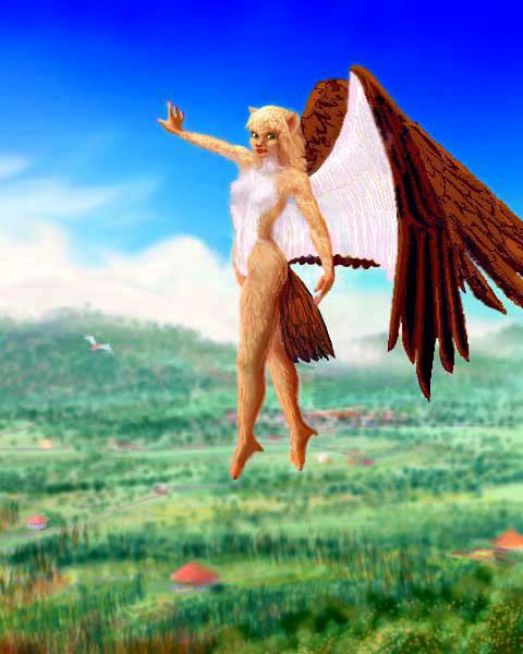
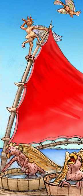
It's only an hour to Rinna's north shore, but it's a glorious hour--sunlit forest! A nearly Terran boreal forest of narrow pseudospruce, not sleetwood. You pause for lunch in a fishing village--not a gryphon keep, but a mixed-species town, mostly icari, like furry cat-headed angels, but also some pegasi and sphinxes. The land feels crowded after weeks of near-solitude. Villages are miles apart, but you're never out of sight of at least a few scattered farmhouses (round, low, with conical red-tile roofs).
It's a two-hour flight north over Rinna Bay, really a sheltered inland sea stained pale blue by glacial runoff.
You land on the Nada Peninsula on Tauno. Nearly 1000 km wide (5-600 mi), Tauno is Nordic but not polar. Glaciers adorn central Mt Tauno, a shield volcano broader than Olympus Mons and 3700 m high (12,200'--modest compared to Olympus or even Alaska's Denali, but to be fair, Tauno's fighting higher seas and gravity).
Most of Tauno's uplands aren't glaciated, but living tundra and steppe, while the lowlands have wide boreal forests. Unlike Alaska, which gets drier as well as colder nearer the pole, Tauno gets drier as you leave the polar zone. More trees grow here on the sheltered shores of Rinna Bay than in the warmer north! There are lowland bogs, but no sleetwood at all--you've left the polar storm zone.
Curiously enough, Tauno has an identical twin half a world away: Erkila in the tropical Hisagazi Islands. Same landforms, same scale, just utterly different climates!
Location, location, location...
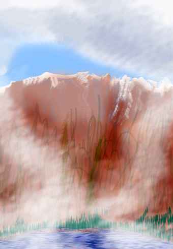
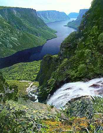
In the morning, you warm up by climbing to a pass between Mt Tauno and a nameless eastern peak about 3 km high (2 mi). At the saddle's summit, two km up, you perch triumphantly on bare red rock surrounded by the white snakes of glaciers. The weather on the far side seems strange--in a clear sky, twisting dragons of mist pour from a canyon in Tauno's flank about 50 km to your left. Is an eruption happening? Let's go see.
You ride the morning breezes along the mountain slopes, quickly learning to skirt the downdrafts over glaciers and favor cliffs of sun-heated rock. By noon the mist curls over you. There are enough breaks so you're not flying blind, but you're tense as you flap up the canyon along a river--not a glacier, like all the other valleys at this height, but a living river, steaming into the chill air. Patchily sunlit cliffs rise a mile above you.
Slowly you piece together the scene--you're entering Tauno's caldera! A great amphitheater, cliff-walled, mist-hidden. The source of the mist is clear now, too--Lake Tauno, 20 km (13 mi) wide, as purple as a bruise, stained by thermophilic bacteria, filling a great oval vent in the floor of the crater. Kept thawed at this altitude by volcanic heat, it generates a plume of mist stretching miles. Black and green streaks of lichen and moss stripe the red cliff walls, fed by the mist. The rim, floating high above you like some dream-castle, is capped in white: ice. It feels eerie--despite its splendor, you're on edge and feel out of place in this temple to ice and fire.
Gliding down the long slope of Tauno to Cape Raxi doesn't seem anticlimactic--you're relieved to be back in the land of life again. And rich life it is. The cape shelters Raxi Bay, making these shores the warmest, driest and most fertile region on Tauno, with rich grassy steppes above tall evergreen forests on the coastal plains. The white, floating shape of Mt Tauno dwindles to the southeast as you glide out onto the peninsula.
It takes a full day to reach Port Raxi near the western tip. You sleep in a real inn, with music and beer and civilization on tap. You can't quite get used to it. After weeks of sprawling, howling wilderness, you could be in Copenhagen.
Well, if Denmark were run by little cat-headed angels.
YRIA
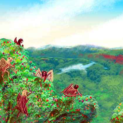
Yria's so kind! Green and mild, 650 km (400 mi) long but slender enough so you're never far from the sea. A few glaciers adorn central Mt Yria, but most of the uplands are alpine meadows, while the lowlands have tall boreal forests. Their dark green is veined with purplish foliage, where pegasi have planted lines of domesticated nut-bearing conifers. You spot a harvest crew--chattering like sparrows as they flutter and hop around the tree, eating as many nuts as they toss into the cloth chutes heading down to the wagon. As you wheel around them, curious, you discover that half of them are sphinxes. Somehow you hadn't thought of cats eating nuts... but of course sphinxes are no more like Terran cats than pegasi are winged horses.
Both species are recent immigrants. Yria and Tauno were discovered by the icari, those winged humanoids with rather feline faces and thick fur. But they came from Valland, northwest of Averorn, and they had to explore the whole freezing length of southern Averorn before finding Tauno. Even the natural insulation of icarian fur was no match for the sleet belt--exploring the vast archipelago was epic and risky, taking generations. But it paid off, in the end, in the discovery of these cool-temperate lands at the far end of the cluster.
How mild? Well, we're still polar enough for a midwinter Long Night up to a Terran month long. You'd think it'd always be the same length--simple geometry--but it's not. Lyr's thick and tightly layered atmosphere (thinning fast as you rise) bends light better than Earth's. So at dawn or dusk, sunlight's refracted several degrees around the planet--rarely under five, and up to ten degrees. Result? The sun seems to be shining above the horizon, when it's really just below it. Sound odd? It happens on Earth too, every day. The setting sun you see isn't there--it's several diameters below its image! A few minutes of extra light at dawn and dusk... But on Lyr, it's more than a few.
At high latitudes like Yria's, lensing means the midwinter dark may be cut short if temperature, stratification and humidity are right. Even when the Long Night is full-length, the cold is not severe--frosts and occasional hailstorms, but snow is a rarity in the lowlands, due to the dense damp air and huge ice-free seas all around.
And in summer, lensing means the Midnight Sun appears for months! Continuous daylight. The result? Annually, Yria gets daylight 5/8 of the time! In southern Averorn, it can reach 2/3, even if the sun's often dim and low. Lensing, as much as Lyr's greenhouse effect, is what makes polar Averorn habitable at all.
For a long time after after discovery, Tauno and Yria were anomalies for Lyr--one-species cultures. Over the next millennium, news of the new lands crept around the world, from West Averorn to Ak'hai'i to Gaiila to the Nyanza Islands, and at last to the mothlike soka, whose homeland in Flandry really isn't that far from Tauno--50,000 km as the rumor flies, but a mere 9000 as the soka sails. For though soka are weak fliers, they're the best mariners on Lyr. Their squeaky little sonar sensed market potential! They started visiting the new land, not only trading goods but instituting something new for Lyr: passenger service, direct from Ak'hai'i, Flandry and Gaiila to Yria.
The concept of a non-flying shortcut was a hard selling for soka captains at first, since many flying Lyrans see it as unnatural, almost sacrilegious not to travel under their own power--you see, it's the will of Mother Sea (under her many names) that some lands should be easy to reach and others difficult. One should follow the routes the Mother intended, see the sights, meet the locals, feel the winds, feed the bugs, freeze, starve...
But Averorn's foul climate eventually beat down even religion. Today, fully half the traffic reaching Yria and Tauno comes direct by ship, not along the endless flyway.
So as well as the ubiquitous gryphons, modest numbers of pegasi and sphinxes now live on Tauno and Yria. The soka themselves still trade here, but few have settled, except in Port Yria itself for business reasons--even Yria's mild northern shore is a bit too cool to suit them. Soka evolved in the subtropics--a touch of frost and they panic. I'm from California; I know the type.
THE EPIC OF HRILL
The best-adapted species for Averorn is certainly gryphons, but how did they get here? They evolved in the north subpolar region, and to get here, they'd have to fly 50,000 km--right across the equatorial zone. Every gryphon that's ever tried died of heatstroke. They're just not built for it.
Enter the soka again. Their ships call at a great island called Hrill, in southern Oronesia. Though Hrill's only 15 degrees north, it has huge, snowy volcanic peaks up to 4600 m high (15,100'); and on their flanks, two Lyran centuries ago, lived the southernmost gryphons in the world--a branch of the small clan representing their species at the Trade Institute on nearby Arinnian. Seventeen gryphons, hearing from the soka of vast, unsettled southlands too cold for anyone else, concocted an outrageous, humiliating plan. They plucked themselves naked, and rode soka ships south over the equator, in shaded decktop tents, pouring cold water on their bare, bumpy skin every hour, until they were past the tropics. They raced south as their pelts and feathers regrew... and won that race. By the time they had visible down, they were in the south subtropical zone. Heatstroke killed one, and skin infections another, but fifteen survived the voyage--at least physically.
But gryphons are the proudest people on Lyr, and they've never lived it down--that image of warriors and queens all pink, naked, flightless, helpless, plucked as megachickens in a stew-pot. While the icari wrote epics celebrating the courage of their Antarctic explorers, the first two generations of Averornian gryphons were silent and ashamed. It was a shock when their grandchicks grew up, uncovered the truth, and started singing a mock epic of their own, celebrating the moral courage of gryphons brave enough to be laughed at. Oddly enough, it caught on--there was, after all, some truth in it.
Today Averornian gryphons have a distinct culture, with a wry humor and humility unheard of in the proud north. Perhaps the best analogy is the Australian shame (but eventual pride) in being convicts banished by England--it too fostered a wry egalitarian humor. Or perhaps the cultural divergence was inevitable--like Australians, Averornians faced a harsh, marginal land where solidarity and sharing are essential and pretension is divisive. Culture follows nature? Perhaps.

Gazetteer: index of places, with descriptions. Or...
TOUR LYR! Climb volcanoes, swim seas, meet weird creatures. First: survival tips! Then, pick a region:
Ythri -- Polesotechnic Chain -- Troisleons -- Roland -- Oronesia -- Gaiila -- Flandry -- Diomedes -- Ak'hai'i -- Averorn
World Dream Bank homepage - Art gallery - New stuff - Introductory sampler, best dreams, best art - On dreamwork - Books
Indexes: Subject - Author - Date - Names - Places - Art media/styles
Titles: A - B - C - D - E - F - G - H - IJ - KL - M - NO - PQ - R - Sa-Sk - Sl-Sz - T - UV - WXYZ
Email: wdreamb@yahoo.com - Catalog of art, books, CDs - Behind the Curtain: FAQs, bio, site map - Kindred sites