ALTAI
by Chris Wayan, 2006
Lyr (home) - map - creatures - cultures - evolution - climate - geology - gazetteer - nomenclature - definitions - building Lyr - more worlds? Planetocopia!
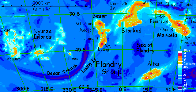
Altai's a cold land two-thirds the size of Greenland in the southern Flandry Cluster. It can't be easily reached by island-hopping--it's 3200 km (2000 mi) from the nearest land, Merseia. Its creatures developed in relative isolation ("relative" meaning plenty of Altai's species are migratory. New Zealand, one-third Altai's size, has more endemic animals! Still, Altai has some; for Lyr, that's isolated!)
If my five-cell climate model is correct, Altai is in a cool-dry belt that makes it a bit like Patagonia or Tierra del Fuego, only flipped east-west--cool windy steppes on the west coast, tundra-flanked volcanoes above dark misty woods to the east.
Lyr tilts 36 degrees, so Altai straddles the Antarctic Circle. Much of Altai should have a midwinter Long Night and a summer Midnight Sun, each about a Terran month long. But Lyr's dense atmosphere (six times our pressure) and higher gravity (not just a big but a steep pressure gradient) create a strong lensing effect in the atmosphere--not just mirages as in our deserts, but a consistent worldwide warping of light, as on Venus. It happens on Earth--when the sun is a degree or so below the horizon, it appears above, making our days always a few minutes longer than night. But on Lyr, this "miraging" ranges from 5-10 degrees--even at the equinox, there's a 7-hour day and 5-hour night! Thus, the effective polar circles are more like 60 degrees than 54. The result: Altai has no midwinter darkness, yet in summer the midnight sun lasts several months! As mirages go, it's a useful one.
Altai's cold isn't just from its distance from the equator, but from altitude. Over half Altai's area is upland; two of its peaks are among the ten highest on the planet. The cold dry winds off their icy crowns stunt trees all over western Altai's uplands.
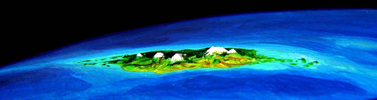
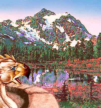
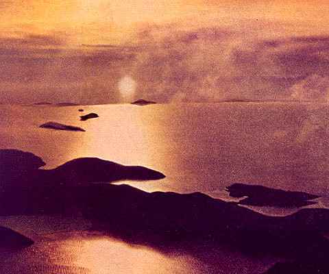
The photo below, taken from low orbit, looks south toward the pole; so the dry west is to the right, the green east to the left--the reverse of the map.
On the map Altai is clearly part of the Flandry Rise, yet none of that region's intelligent flying species ever found it. 2500 miles from anywhere! Since discovery, a few experienced fliers have made it alive to Altai, but they were daredevils--Lindberghs without the plane! Don't try it. It's at least 32 hours nonstop, and that's if your navigation is pinpoint-accurate. We'll just have to wait for a soka trading vessel to sail there. There's still no regular passenger service, for the simple reason that there's little profit in it yet--Altai was only recently settled. In fact, the soka only discovered it a Lyran century ago... and they don't want it. Too cold! Still, they're happy to plant more cold-tolerant species there, in hopes of future trade.
The soka think ahead. People are a long-term crop.
The voyage takes five months. Of course that's deceptive--Lyran months are short. Whipped around by Lyr's huge mass, the giant moon Oisin orbits in less than 11 Lyran days, (5.3 Earth days). So it takes us less than one Earth month to sail from Cape Tridaig on Merseia to the Varyak Islands, a triangular archipelago off Altai's northeast tip. Really, we've followed the Varyaks all the way--they form a line of seamounts linking Merseia and Altai, but since they don't emerge even as reefs for nearly 3200 km (2000 mi), they're useless as a flyway. Even when the Varyaks do surface, at first they're just shoals and rocks. But the chain grows quickly until, near Altai's coast, it forks; North and South Varyak, just off the coast, are each 100-120 km long (60-75 mi). These islands shelter Varyak Bay, so the water's warm--yet another reason east Altai is milder than the west.
Altai's isolation pressed its fauna to choose a couple of extreme evolutionary paths: adapt to the cold by growing large and sacrificing useless wings; or, become migratory athletes, strong-winged and light, sacrificing dead weight. Dead weight like brains! Altai and the equally lonely (and even chillier) Averorn Archipelago are the only Lyran regions that didn't evolve at least one intelligent species--and the climate is probably to blame.
THE EAST
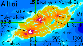
We come ashore in the modest settlement of Varyak Bay, at the mouth of the Tumurji River, the largest in eastern Altai, 320 km long (220 mi). Its lowlands are as warm and fertile as Altai ever gets--tall, dark "pine" and "cedar" forests, dotted with bright streaks where icari have planted their distinctive, decorative nut and fruit trees amid the somber native woods. Inland the land rises and the trees grow shorter, breaking into meadows and glaciers on cloud-wrapped Mt Tumurji, 3300 m high (10,800).
For a full day we climb inland over these dark pine ridges and curve around Tumurji's north flank into the Baligh basin. The Baligh River ("ba-LEEGH"; more like "believe" than like "lie") is 450 km long (280 mi). Its lower reaches resemble the Tumurji Basin, and along the sunny north coast, sphinxes have dug several fishing-lairs into the bluffs and sea-stacks. The Lower Baligh is about as rich and diverse as Altai gets.
But as we wheel around Mt Tumurji, we're not entering those settled lowlands, but the upper half of the basin. This is downwind of Tumurji, and the great peak casts a rainshadow, thinning the great forest to open woods dwarfed by summer drought and winter cold.
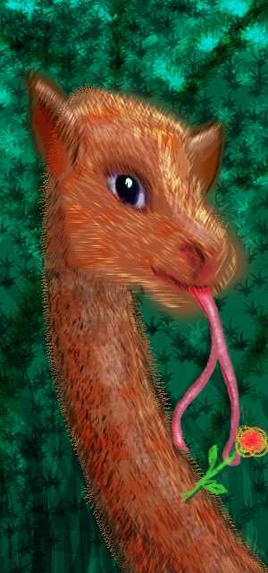
Still, I led you this way for a reason. In the open woods up here, it's easier to spot altaffes.
Lyr's sunlight is weaker than Earth's, so its forests generally have dim, sparsely vegetated understories. These encourage the evolution of big giraffelike tree-browsers as well as arboreal hunters and fruitpickers. Several "giraffes" have evolved independently, from quite different stocks. Two are intelligent--the tauraffe of Diomedes, and the elaffe of Troisleons.
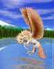
But on Altai, this (non)group of evolutionary parallels reaches its culmination. The altaffe is the largest land animal on Lyr, probably because the cold encourages gigantism. Shaggy, stocky, altaffes run six to seven meters tall--the woolly mammoths of the giraffe world. Using its half-meter-long tongue to browse new growth high in trees, the altaffe is a bright animal with a long lifespan and complex social structure. It even has the potential for "hands", and thus, material culture: that tongue is forked and quite prehensile. A drooly, two-fingered civilization is better than none at all!
But unlike the elaffe and tauraffe, the altaffe is still only a bright animal--its brain is apelike, nowhere near as complex as elaffe, tauraffe, human or elephant brains (all comparable). Maybe in ten million years... or maybe not! Evolution seems to proceed slowly on Altai.
Species ripen slower when you keep them in the fridge.
The upper Baligh basin is reserved entirely for the altaffes, though of course they aren't hunted anywhere on Altai. You stay the short night in a lodge at the headwaters of the Baligh. It's more like dusk than true night--the sun's barely below the horizon, a perpetual dawn due north. You sleep uneasily in that relentless lurid light.
In the morning you peer south over the divide. A pale gleam surprises you. Is Altai that narrow? No, it can't be the sea, it's the distinctive milky jade of glacial melt. You consult your map. Lake Rurik, some 200 km (125 mi) long and half as wide, filling much of the valley between Mt Tumurji and Mt Bourtai ahead of us to the west. It pours into the long Zeya River, which drains most of southern Altai. The Zeya Basin is a huge, dark, chilly evergreen forest running 1000 km along the coast and 500 km inland to Mt Bourtai, broken only by the lake and alpine meadows around Bourtai, now dead ahead, heaving over the horizon even from 200 km away. It's not a formal altaffe reserve, because there are no settlers to ban. Not one of the 19 known intelligent species on Lyr wants the place.
CENTRAL ALTAI
Mt Bourtai dominates all central Altai--a volcanic highland more than a single peak, 4500 m tall (14,800'). The glaciers mantling Bourtai's broad shoulders are the source of most of the large rivers on Altai--the Talyma and Zeya as well as the Bourtai on its north slope. I said ice-mantled, not ice-capped: the highest summit and several nearby vents are bare. A single ominous wisp of steam tells you why. Bourtai is dozing lightly. When (not "if") it wakes, those glaciers will come crashing down, in a horrendous slurry of mud, ice and steam, scouring the river channels and lowlands all the way to the sea. No villages on these riverbanks, not even a port at the delta; they're strung along the north coast on lesser watersheds sheltered from Bourtai's threat. News of the catastrophic mudflows on Sherrin, on the far side of the world, took a while to reach lonely Altai; but reach here it did. And Lyrans think long-term.
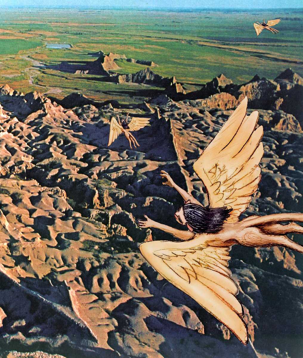
We'll head into the upper watershed of the Bourtai River, on the warmer, sun-facing side of the mountain. An hour later, on a crag above a lake, you spot a small stone castle. A gryphon keep! If you've toured Averorn, it may seem odd that you haven't seen any keeps before. Why is Altai so unpopulated? Averorn is even colder, after all, and gryphons have settled there in substantial numbers. But forbidding though its climate is, Averorn can be reached (and was) by fliers from Prasiyo, and so is linked (however tenuously) to the worldwide net of flyways, news, and gossip, and for those who couldn't handle the long hard polar flyway, soka traders eventually started ferrying passengers. In short: Averorn was forbidding, but on the map. Altai wasn't.
There are lesser Altais visible on my altimetry scan that Lyrans still haven't found--two whole archipelagoes I've dubbed the Borthu and Dahia Islands, and a tiny Antarctica, and nameless isles in the northern Alianora and Oronesian Seas and the southwestern Sunward Sea, and three Hawaii-sized islands southeast of Rorvan, and two east of Gaiila, and... well, you get the idea. It's one of the hidden costs of flight--it's faster than sailing, but with a shorter radius, so islands over 1000 km from known land are likely to stay unknown. It's not that the Lyrans are lazy. Lyr's seas are just seven times the size of Earth's! Using mere starnose-dolphin gossip and silk charts, they've mapped more surface area more accurately than all our probes of the solar system combined. And they did it in person, using their own effort and skill... risking their lives with every flight.
THE WEST
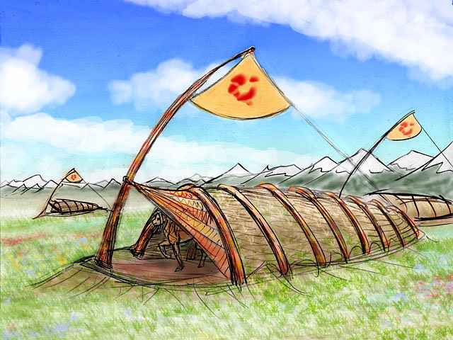
The next day, and the next, you glide across the broad forested slopes of northern Altai: first the Bourtai basin, then the Talyma. But the Talyma River's in a drybelt; the forest thins to a dry steppe with desert canyons in the upstream mountains. The Talyma's branches wind west through such canyons for 500 km (320 mi) from Mt Bourtai to the coast. In places, fluted golden badlands break the windy grass plain. Wheeling over one such cragfield, you meet a family of fellow tourists--sphinxes from the northeast coast. From their whoops and grins, they find it exciting. The hoodoos below look stark to you, speaking of erosion and deep time, of bones and drought and dying lost in the stone maze... but apparently to a sphinx they look friendly, beautiful... sexy? Nice perches, sensual shapes. Beauty's not just in the eye of the beholder. Wings have something to do with it too...
The steppes and canyons of Talyma Basin are home to another species of settler called pegasi. There are also a few icari, the people who first explored Averorn; Altai is at the limit of these two species' cold-tolerance, but both species do vary--pegasi from the northern Hesperian Islands in Ythri and icari from Prasiyo in the Ak'hai'i Group are almost adapted for Altai. Almost.
Some of the pegasus adaptations are cultural, as you find out when you sleep in a pegasus lodge and find everyone crawling into bed with you. To stay warm, they sleep in a squirming heap. If you call it sleeping! They drowse, snuggle, squabble, make love, nurse pups and have little pillow talks. It takes some getting used to, especially since you're a forced participant. Pegasi figure if you're in the heap, you're one of the tribe...
In the morning, you feel a little sticky, but much educated.
Flying west, a monster grows on your left til it fills the horizon: Mt Subotai, a volcano rising to 4800 m (15,700')--only three peaks in the world are higher. Of course, on this deep-sea world, "higher" and "taller" are context-dependent! No Everests, plenty of Hawaiis. When you factor in the underwater parts, Subotai and Bourtai are true giants, almost Martian in size. Subotai is inactive right now, so it's heavily glaciated compared to Bourtai--quite Alaskan or Icelandic. On a world where year-round ice is rare, it's a sobering sight. And feel! Cold winds pour off the great icefield, whipping the low bunchgrasses on the hills. Trees huddle only in sheltered canyons. So do the pegasi.
All day you fly west, riding that cold blast; across the upper Talyma Basin, over a range of stony hills, across the rippling golden Subotai Plain, broken only by rare pegasus lodges, looking like capsized boats in the great grass sea, their doors all facing away from that relentless wind...

TOUR LYR! Climb volcanoes, swim seas, meet weird creatures. First: survival tips! Then, pick a region:
Ythri -- Polesotechnic Chain -- Troisleons -- Roland -- Oronesia -- Gaiila -- Flandry -- Diomedes -- Ak'hai'i -- Averorn
World Dream Bank homepage - Art gallery - New stuff - Introductory sampler, best dreams, best art - On dreamwork - Books
Indexes: Subject - Author - Date - Names - Places - Art media/styles
Titles: A - B - C - D - E - F - G - H - IJ - KL - M - NO - PQ - R - Sa-Sk - Sl-Sz - T - UV - WXYZ
Email: wdreamb@yahoo.com - Catalog of art, books, CDs - Behind the Curtain: FAQs, bio, site map - Kindred sites