Western Gaiila
by Chris Wayan, 2006
dedicated to Poul Anderson for his remarkable world-building
Lyr (home) - map - creatures - cultures - evolution - climate - geology - gazetteer - nomenclature - definitions - building Lyr - more worlds? Planetocopia!
INTRODUCTION
New on Lyr? First-time orientation--strongly advised! Lyr is weird.
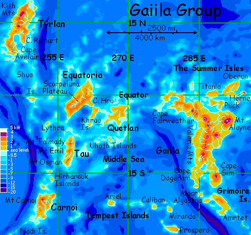
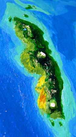
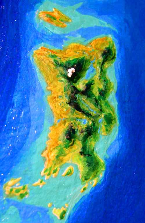
Gaiila ("guy eel ah") is an equatorial cluster containing six large lands: Gaiila itself (3/4 the size of Australia) in the east, and Quetlan, Equatoria, Tau, Carnoi, and Tyrlan, in the west. The group totals ten million sq km (4 million sq mi), larger than Europe; just over half that is Gaiila. This tour covers most of the west: Quetlan, Equatoria, Tau, and Carnoi. It excludes Gaiila, Tyrlan, and the Tempest Archipelago, which have their own tours.
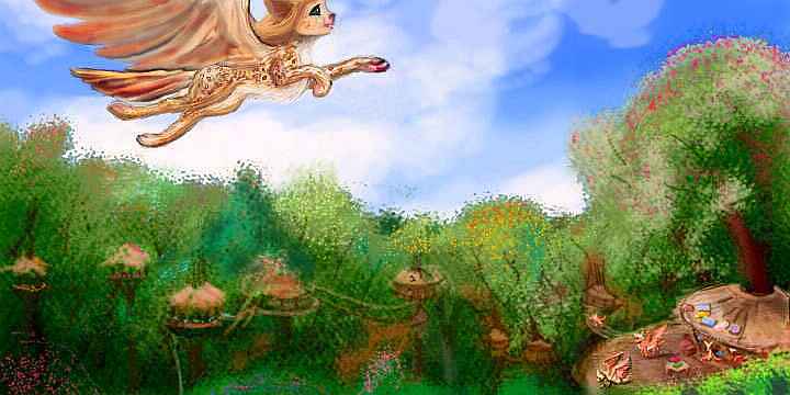
We'll start in the Clodia Islands, off the tip of Cape Fairweather on the Gaiilan mainland. This archipelago is Amazonian jungle with most of its life in the treetops. The inhabitants are almost exclusively griffets, hawk-winged catlike little people who fill much the same ecological niche as parrots--if parrots built woven villages, sang chorales, and played 3-D chess. You've been staying in the guest room--the only one big enough so you only bang your head every other time you move. I first wrote "sleeping in the guest room", but it's hard to sleep with all that griffet chatter. A noisy people. Or is all the rain just making you grouchy?
In the morning you notice these particular griffets have a couple of truly weird pets--monkeys with a marsupial pouch, four clawed, birdlike feet and a Mohawk crest. And wings, of course, and huge cartoony eyes--but on Lyr you take those for granted!
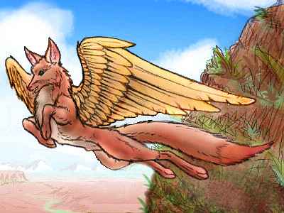
Then one talks--more articulately than any griffet. Not pets, friends. A new intelligent species: your first koreens. These are pioneers from the west--we'll be seeing lots of them from now on.
From this village near the western tip of the Clodias, it's a 1200-km jump (750 mi) to the mainland of Quetlan. This is the great divide between east and west Gaiila. It's hard enough for you--imagine the challenge for someone cat-sized! That's why the Clodias hold the westernmost significant populations of griffets, and why Quetlan is the eastern edge of the koreens' normal range.
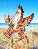
 KOREEN | 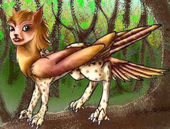 GRIFFET |
|---|
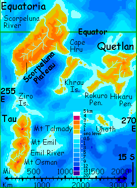
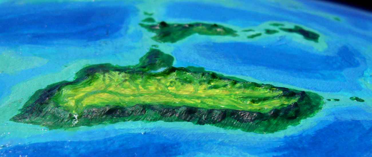
The coast of Quetlan looks continental to you, as you approach--an endless green wall. Quetlan's big--1600 km long and 900 wide (1000 by 550 mi). It's a volcanic shield that's eroded into a low, complex mass of steep, dissected ridges; craggy Mt. Quetlan, 2300 m (7600') is the old volcanic plug. It looks like a Hollywood version of Tahiti. Quetlan's covered in dense rainforest; only the drier Rokuro and Hikaru Peninsulas in the far south have any clearings at all.
If this were Earth, Quetlan would have a hundred languages and a thousand tribes, some at war, some
quite unaware of others--a few unaware they're even on an island! But flight transforms it all. Instead of a dark, impassibly rugged maze, Quetlan's a bright, fertile, treetop Eden--to the chattering koreens who flit above its dissected valleys.

The jagged, cloudwrapped crags of Mt Quetlan don't look like tourist-level flying to you, so you flap down Quetlan's east coast instead. You later learn half a dozen travelers have died this year in that stormy interior. Not a land for amateurs! Nor for koreens. It's too cold. Up there, most of the population is a larger, relatively humanoid species called icari, looking like little furry angels with cat heads. Their thick pelts let them thrive in the chilly cloud zone.

Around sunset you find a sphinx village hollowed into a rocky point, and sleep in a guestroom with a doorway dropping sheer into the murmuring sea. One careless step and you'd be dead, but by now living atop a cliff with flying lions seems homey and peaceful, compared to a creaking, flimsy wicker nest atop a sixty-meter tree, full of eager, inquisitive hosts with piercing voices and no interest in sleep...

Maybe it's just travel-fatigue talking, but compared to quietly purring, elegant sphinxes, the koreens seem a bit too much like the Wicked Witch of the West's flying monkeys. An unfair judgment--sphinxes catnap around the clock, so they're up all night too, crawling into bed with you and licking curiously. But at least they're not noisy about it...
In the morning the coast bends west. A long, mountainous island rises on the horizon. Around noon you discover it's not; a low, jungly isthmus links it to Quetlan ahead. It's called the Hikaru Peninsula--a land in its own right, a wedge of hilly, open monsoon forest 350 km on a side, sunnier than the rainforested mainland. You're tempted to detour--Hikaru is a springboard off Quetlan into the Middle Sea, leading to the Uhoth Isles 700 km south, an even sunnier land the size of Hawaii, with mixed tropical forest and veldt, looking rather African. Coral islets beyond Uhoth form a bridge all the way to Tau. This shortcut has made Uhoth a short cut for east-west fliers, so there's a surprisingly cosmopolitan and diverse population. But Equatoria and Tyrlan still lie north and west--we can't skip the biggest lands in West Gaiila just to see little Uhoth.
Oh, well. Let's not go there and say we did.
A day west of Hikaru is a similar peninsula with a similar name: Cape Rokuro. 400 km long (250 mi), it too is opener and sunnier than mainland Quetlan. But Rokuro points nowhere, so you just cross its narrow neck and go on up Quetlan's coast to the end of a small cape where you sleep in a second sphinx-nest.
KHRAU
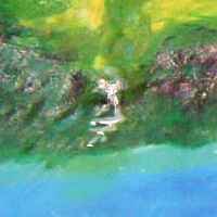
The next morning your sphinx hosts point out a chain of islets--your bridge to Khrau. You hop west nearly all day, resting on each islet, until, near sunset, a long black coast looms ahead, silhouetted: the steep shore of Khrau. Great black cliffs, striped with green and white: trees clinging between waterfalls...
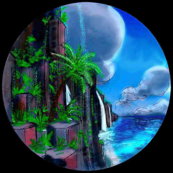
Over a strait an hour wide, you reach Cape Hru on Equatoria. At first glance you're disappointed. It looks just like Khrau, except it's a sunny south coast instead of a shady north. Jungle cliffs, little waterfalls, small showers, rainbows... More damn paradise! (How easily humans get bored!) It takes four hours to the mainland, for Cape Hru (an unvoiced, purring, breathy Roo, almost "shoo!") is a good 350 km long (220 mi).
But at last you face the mountain wall of the mainland--and, following sphinx-advice, climb straight inland. Up through the clouds... and out of them! The grey cloudwall fades before you; you look down on a green-gold plain.
Mainland Equatoria is nearly continental--2000 km long and 1000 wide (1300 by 625 mi). As you've seen, the lowlands and outer rim are rainforest, but most of it is a great upland, the Scorpeluna Plateau, 2 km high (6-7000'), the size of Madagascar. The plateau's all one basin, draining inward to the Scorpeluna River, 1500 km (900 mi) long, and a mile high. The coastal ranges catch most storms on their outer slopes. Lands cut off from the sea like this are often deserts, but Equatoria's in the torrid zone, where even mere leftover rain is substantial. Scorpeluna's a mild fertile plain of mixed groves and meadows, like parts of highland Ethiopia. The meadows are the first you've seen in weeks. Almost Mediterranean!
Grazing Scorpeluna is an anomalous herd of antel. These lush prairies broken by fruit-tree groves support icari as well, and even a few sphinxes. Interspecies contact is close and constant, so these antel are the calmest, most sociable you've met. I mean, you can actually meet them--no panicky pigeon-rush into the air. You see antel in the villages talking with sphinxes--like deer joking with lions! You even meet one mixed family with four mates: a sphinx, two icari, and an antel. In cosmopolitan Oronesia, among scholars and diplomats, you'd expect this; but it's startling here in a village that might as well be in the New Guinea highlands...
The next day, AND the next, you glide down the long river until it leaves the highlands, punching through the coastal mountains and then dropping one mile in twenty to the sea: the Scorpeluna Falls, dozens of cataracts and four great falls up to nearly 100 meters high and two kilometers wide. Niagara, Iguaçú, and Victoria Falls all in one! Even in the orbital photos, a painstaking fusion of rare cloudless shots in this generally cloudy region, the plume from the falls is visible from space--it takes miles to dissipate in the humid tropical air. Unfortunately, that means Scorpeluna Falls are hard to see from a distance. And I'm sure your strap-on wing training course warned you thoroughly about downdrafts near large waterfalls. Stick to climbing (wingless, on wet mossy rocks, in high gravity) to the brink of the abyss instead. Now THAT's safe!
Eventually, when offworld tourist traffic grows to the point that the locals realize there's a living to be made off them, there will be paths or more likely swinging, precarious suspension bridges leading to viewpoints below the falls, and they'll become a galactic must-see. But for the time being, they're rather difficult to see well. But even just hearing and feeling that rumble in your bones is worth getting drenched.
TYRLAN OR NOT TYRLAN?
From the Falls, you ride the updrafts along the Coast Range back south a couple of days to West Cape, the broad bend that's Equatoria's westernmost point. Here you face a decision: see or skip Tyrlan, second largest of Gaiila's six lands, a rugged, spectacular place of waterfalls and canyons--but far off any flyway.
Well, put it off til morning. You bed down in your koreen guest-pod in West Cape Village. Your bedroom lurches like a drunk sailor? Six of the Wicked Witch's flying monkeys are snuggled up next to you, and they squawk in their sleep? You're too tired to care anymore.
Well, in the morning let's say you decide to skip the north. You launch off the guest-pod platform and glide south, riding the updrafts as the sea winds push up the coastal slopes. Easy flying, but monotonous, and you'll be at it all day. Around sunset you reach South Cape.
Your next day starts out pleasantly, with hourlong hops between fertile islands of the Ziro Chain. But after lunch on the third island, all afternoon, only reefs appear ahead. At sunset you spot the unimaginatively named islet of Midway (one of at least a dozen on Lyr, for obvious reasons) and spiral in. Low hills, dense rainforest. Good! Shade and fruit. It's hard landing, for there's no beach--trees and vines right down to the tideline. But you clumsily collapse in a tree and climb down. Sleep six hours, get up, and hop south again all day. At least there are islets regularly now, and at last the low green coast of Tau spreads before you.
TAU
Tau's a narrow island 1500 km (900 mi) long, as big as France or Madagascar, though it's mostly hilly--the Emil Basin is the only big lowland. This north shore is dense forest, but from Mt Emil south, the woods open up, thinning to savanna along the west coast, and even a small desert downwind of Mt Osman.
The low coast steadily rises as you head south toward a great cloud-castle on the horizon that never moves. By sunset it looms above you, magenta and gold, and its cause intermittently bares itself: the sharp tooth of Mt Talmady, highest peak on Tau, at 3300 m (11,000'). It's certainly no neat volcanic cone--is it a remnant of a greater volcano? A lava plug, maybe, or a surviving shard of a cone that exploded? Or is it just an uplifted, tilted chunk of crust that's eroded steeply in these heavy rains? Cloudforests and fern-meadows cover the jagged ridges around it, and tatters of mist make it hard to examine. You dare not go too close to those windy cliffs, not with such poor visibility.
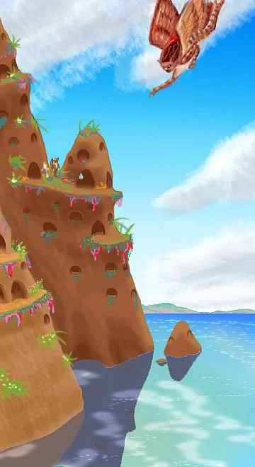
You seek a safe place to land in the dusk. Through a break in the cloud-banners, you spot a mountain lake at Talmady's foot. Strange. There's a craggy islet with glowing eyes--oh. Lamplit cave-mouths. A village! Floxes, sphinxes, icari? When you land on a ledge and timidly call inside, it turns out to be the last: little furred angels who welcome you to the evening meal of fish, nuts, fruit, and big feathery leaves (even here in the cloudforest, Lyran plants never have big, unbroken leaves. Either they're highly divided or they have slits and holes. They need to--in Lyr's dense air, modest winds will shred solid leaves). In retrospect, who else but icari? We're far outside the range of gryphons, and who else has thick enough coats to stand this weather? Sphinxes and floxes might live on crags like this, but only if they're sunny.

ON OUT-LONGING
You spend a quiet evening hour (all that's wise, given Lyr's five-hour nights and your Terran need for long sleep) listening to some quite haunting songs. Icari like sliding harmonies. As two or three voices descend together, three or four notes apart, you have awkward moments when those big eyes and feline ears make you think of yowling cats--quite unfair, for there's audible artistry here. Perhaps you're more aware of the species difference because you're the only non-icarus in the room. You've heard songs in inns all over Lyr by now, but many bands are mixed (for a wide voice-range) and nearly all audiences are.
But only these waterproofed angels can stand these misty, out-of-the-way uplands; and their plaintive music sounds insular and a bit lonely. Cast away on an ecological island, these people may suffer a mild touch of an ailment Terrans foolishly assume is universal: isolation from all other species by virtue of personhood. Strange to come all the way to Lyr to recognize that loneliness--especially since, on Lyr, it's so easily cured. Just take wing toward someplace cosmopolitan, like southern Oronesia--you'll meet half a dozen species you can talk to! And, you learn from the singers, some young icari do. Not for lack of economic opportunity or friends or mates, but out of sheer hunger for otherness. "Out-longing," they call it; though it might just as easily be translated "species deprivation."
The next day, pondering that lesson, you ride updrafts on the windward side of the highlands, soaring effortlessly south all day (except for dodging clouds so you don't slam into a ridge) all the way to Mt Emil in central Tau. Slowly you slip out of the cloudforest belt... the skies are just dappled with cumulus now, and the ridges are clad in open pinewood.
Emil's definitely a volcano--a cone worthy of Fuji, 3100 m (10,300') high. Basking in sun, it's more scenic than cloudveiled Talmady was. You skirt the great peak to the east. Near sunset, you spot a pink cascade in the alpenglow on the south face--the source of the Emil River, Tau's largest by far.
You follow the Emil southwest out of the highlands, into the dusk, and find a warmer, lower-altitude crag-village. This one's a mixture of icari and sphinxes. You feel the difference now, that distinctive Lyran fairytale glow--each species enjoying the other as huge, crazy pets who can talk back, who'll pull you out of your own species' mental and emotional traps. That lonely crag-keep on Talmady Lake was life in a minor key; just a few sphinxes shift it to major!
The next morning you slip down the winding Emil, pine woods opening into scattered hardwood groves, then into rolling savanna. Antel heaven! It's a major art site, full of line- and even texture-art composed entirely of carefully placed black rocks dotting the golden hills, viewable only on the wing. Just connect the dots!
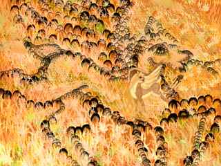
But that's how to see antel art, not how to do it. Antel artists don't connect the dots, they KICK them. As you pass a rather wobbly drawing, a lone antel in the middle of it hauls off and mule-kicks a black rock the size of your head out of line. Oh. No, she kicks it into the new line. A better line, you hope. How much sheer patience kickrock art takes! All trial and error. Mostly error. Only by taking wing can you check your work--stepping back from the canvas is hard when it's 100 yards across!
Leaving the doe to her Tantalus task, you fly on over the golden veldt. On the horizon, to your left, a third volcanic giant slowly grows: Mt Osman, the highest peak in southern Tau, at 3200 m (10,600'). Like the others, it's snowless, at least for now; in global winter, this one's far enough south to get regularly dusted. Wooded to the top, Osman's far greener than the Emil Basin: it snags the few storms blowing in from the east. That casts a rain-shadow downwind, where we're headed--as we near the Emil Delta, even the dry gold grass frays like an old carpet, baring red earth. Only the floodplain is green here. It's not quite the Nile cutting through the Sahara (not with that great green peak reminding you how small this desert is) but still startling after thousands of miles of Gaiilan jungle.
South of the delta, the Osman Desert continues along the coast, but within an hour, the savanna's re-invading, and even in its heart, the red land had green veins--streams dropping from the highlands. One canyon wall has holes as if giant cliff-swallows have dug nests big enough for dragons. A cliff-village of floxes? Yes, there's one now, spiraling down to the winding, irrigated fields on the canyon floor... The floxes, looking like winged coyotes, welcome you. They speak in short simple phrases (and rumor has it they're worse at math than syntax) but floxes sure can cook! You love the dinner--smoky, spicy, sour, sweet, resinous--a taste symphony. Of course, it helps that a flox is about half nose and tastebuds by weight!
You love the guest room, too--a stunning view over the canyon, and utterly silent due to those thick rock walls. No jungle creaking, no wicker floor swaying... you get the best sleep you've had in weeks.
In the morning, you're scarcely in the air before the desert's behind; in an hour, you're out on Cape Osman, the southwestern tip of Tau. Great whalebacks drop suddenly into the sea. Trees huddle along watercourses, but cling to the cliffs, watered by a low morning fogbank--rain is still scarce here, but California-style summer fogs add some moisture and mitigate the heat. Aromatic scrub covers the slopes inland, where a family of antel graze.
HIRHAROUK ISLANDS
You climb above the fog and head out to sea. Your long black shadow dances on the fog-top before you. Over the hours, your shadow shrinks and falls behind, the fog burns away, and still you fly steadily west-southwest. It's over seven hours to the Hirharouk Islands, the only flyway south from Tau. The last two hours are hard--not just fatigue, but the setting sun glares in your eyes. No clouds, no relief. Sunset, usually spectacular on Lyr, is both painful and dull. Cloudless zone! It's a harbinger of the land you'll find ahead.
By Oisin's brilliant light (the ice moon is just over half-full, but so large and reflective it's already twice as bright as Luna ever gets) you spot North Hirharouk ahead. You land on the beach, exhausted, and sleep til dawn, when you go looking for water. Hours pass, and you can't find a thing! The Hirharouks (the rh is a strong, unvoiced rrr, almost a "sh") are a trio of desert islands, each around 200 km across. Trapped in a high-pressure drybelt, with no high mountains to squeeze rain from the sparse clouds, they're hot dry grassy hills and scrubby desert lowlands. Hard country for travelers.
At last you spot a pool in a rocky draw, and land by it. When a herd of winged deer peer out of the rocks at you and ask who you are, you're as startled as they are... You've stumbled on an antel village, its rock shelters so classically minimal and natural-looking you failed to recognize it. This little pool is their municipal reservoir!

But they're Lyrans. They let you drink and invite you to dinner, though in this harsh land most of their food is too tough for you--they can digest cellulose, and you can't. But you can sleep, and drink again, ritually, in the morning, and be on your way before you strain their fragile economy further.
You later learn it's not all like that--you got off the main flyway, which follows watercourses across North Hirharouk. Many villages have enough water for modest irrigated gardens.
From the southern tip of the island, it's a couple of hours to Middle Hirharouk. Though the drybelt here is just as bad, Middle is larger, with higher hills; it snags significantly more rain in winter and light fogs even in summer, though by now (midday) it's clear. You ride thermals up to the hills, and then follow a standing wave of updrafts along their east faces. Hawk highway!
Before sundown you're on the southern tip of the island, and land in a relatively un-shy, un-disguised antel village. They're used to tourists here--they collect on this point, and you have an interesting early-evening sing with a traveling band specializing in four-part vocal harmonies. They have a huge range, since the band has three species in it. One, of all things, is a griffet. You're amazed he crossed all that dry, treeless country alive, let alone the sea-passages. He says "Well, yes. South Tau scary! And, cross to, to North Island, I got sohhhh tired. I start FALL! But Koosha, here" (hopping onto a sphinx's shoulder and rubbing his face against the ear of his bandmate) "let me ride on her back." Of course. To a sphinx, even an adult griffet's as light as a kitten.
Still, it makes you realize how rough road trips are for Lyran bands. No roads.
It's not esthetics, then, that makes Lyran musicians emphasize the voice so much. It's transport. What's the lightest instrument you can carry? Yourself.
In the morning, you fly alongside the band, a bit worried about that griffet. Two hours into the flight to South Hirharouk, he rests briefly on sphinxback, then takes to the air again, fluttering stubbornly on. What musicians will do for their music! For some reason you recall that antel kicking rocks around the Emil Plain, and silently amend your thought: what artists will do for art.
In late afternoon you reach South Island, the largest and ruggedest. You see it long before you're near; these larger hills force the winds up, crowning the hills with a cloud-tiara. Trees line all the watercourses here, and the larger streams look permanent. With each isle, you're creeping out of eco-poverty.
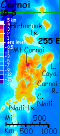
The next day you have to part with the band; they're singing around South Island before proceeding to Carnoi, and you're feeling impatient with the dry Hirharouks. So you cross straight over South's spine and on south over a shallow sea, as pale as the heat-haze sky. Three hours later, you land on the beaches of Carnoi. The last Gaiilan mainland!
CARNOI
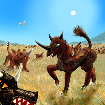
Carnoi's 1350 km (850 mi) long, and up to 800 (500) wide, rugged but low, except for Mt Carnoi in the northwest corner, reaching 3300 m (11,000'). A high-pressure zone lies to the north, so the northwest coast is desert and the west coast savanna, though the highlands and east coast have patchy woods. It's rather Californian in climate, but Terran tourists will think first of East Africa. Big, flightless grass-eaters (and associated predators) dominate western Carnoi, as they do most of the Tempest Islands to the east--a fauna quite unlike the winged rainforest canopy-dwellers of Gaiila, Equatoria and Quetlan to the north beyond the drybelt. These "lions," "rhinos", "zebras", and "hyenas" look like cartoon monsters, with ridiculous little vestigial wings and silly oversized horns and fangs. They quit looking silly if you stray too near! In the strong Lyran gravity, they have squat builds, huge muscles, fast reactions... and hair-trigger tempers.
The local antel are the nervous sort again. But then, you hardly notice, since everyone else is, too.
Including you.
The Coya River drains most of northern Carnoi. You fly upriver, gawking at the wildlife. A few look comical, like the polka-dotted "rhino", but for the most part, all you can think is "Wow! How ugly!" Of course your perceptions are colored by months of seeing mostly lean, elegant fliers, with their strict weight limits. Maybe the nonfliers of Earth would look ugly now too...
Including you.
Two hours upriver is Lake Coya, an oval 140 km (90 mi) wide and over a thousand meters deep. It must have been a bay cut off by lava flows from Mt Carnoi, at some point, for far below the sunlight lies a layer of cold brackish water, preserved for millennia.
The Coya turns west toward its source on Mt Carnoi, visible now on the horizon as a cloud-castle over a cone streaked with white--the first snow you've seen in months. Since Gaiila or Tyrlan, 8000 km back? You're not even sure.
Time to leave the Coya Basin. You head on south, over low mountains to the Carnoi River, running southeast to the coast. You follow it down. Gentle hills, the greenest since northern Tau. Broadleaf trees flutter luxuriously in the humid wind. It reminds you of Georgia as it must have been before the European Invasion. Peaceful country; the scant grass under these dense trees isn't enough to feed the largest monsters of the savanna.
To your surprise you find koreens high in these trees. But of course they had to be here--from their homeland in Diomedes, they passed through on their way to the rest of Gaiila. And yes, I'm attributing intent. The tribes who settled Australia and America spread blindly, not knowing what a vast land lay ahead. But though koreens can't even string together a complete sentence, they're excellent spatial thinkers--they have to be, to navigate through the 3-D labyrinths of the rainforest canopy. They read maps, and they piece together travelers' tales from other species. So they knew of the humid lands to the north and east--koreen Edens! But a few perverse koreens, tired of the great migration, must have liked this little tree-oasis in the dry zone, monsters and all...
You're glad they're here. You stay in a treetop guestroom on an island in the Carnoi Delta.
The next day you wing south along the shore to the chunky, squarish 200-km Nadi Peninsula, a still greener region getting light rains off the sea from the south as well. Lush broadleaf forests here. Koreens fill the canopy, but icari live in sea-stack eyries off every point, where the monsters can't reach. You stay in an icarus eyrie noisy with surf--but at least, unlike a flimsy woven koreen guestroom, it's not rocking with the wind...
West to Nadi Bay. Here the shores are more Mediterranean, opening to meadows. The grass attracts more monsters, of course, so you use Bay Island (which the larger species haven't reached) as a stepping-stone to hop across Nadi Bay. You swim and have lunch on the island's western beach, enjoying the relaxed, monster-free ambience... It's a crowded, chatty scene. Mostly locals, of course--the tourists are all inland gawking, but these folks have seen monsters all their lives. Later you skim along the shore to West Cape, resting once in a tree, once landing in a treetop icarus village. Treehouses are as exotic for icari as for humans, but living on the ground is impractical here. The place looks like a scaled-up koreen rookery--and that's exactly what the icari did. No point reinventing the cantilever...
As the sun drops and reddens, you leave Carnoi. Farewell, Monster Island! No hard feelings.
It's only half an hour across the strait to the first of the Nadi Islands, a hilly strip 100 km long, paralleling the shore; but here you pause. For here on North Nadi you have a choice to make. The Nadi Archipelago continues off the map, forking into two chains, both vital flyways, but difficult. The south chain, called the Lenidel Islands, leads to the Ak'hai'i Region, land of the reclusive witweets. The Lenidels are shorter, and mostly easy hops, but still 3800 km long (nearly 2400 mi), comparable to crossing the Atlantic Ocean on a hang glider. At least Lindbergh had a plane...
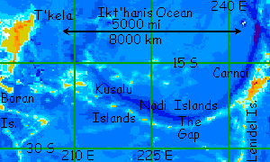
The Nadi Chain continues west, but soon shrinks to small, semi-arid atolls. As well as water problems, there's a dangerous gap of 1000 miles between two islets--a nonstop flight a good 16 hours long, and you'd better stay on course! Drift and you're dead. There's nothing else out there for 5000 miles but deep sea. Still, "persistence furthers": the Nadis lead in the end to the huge Diomedes Region, origin of at least three intelligent species.
You're experienced by now, but the route west intimidates even native Lyrans--thirst, fatigue, and the risk of getting blown off course.
It's a good thing you can just click a link and be there, isn't it?

TOUR LYR! The following route snakes around Lyr, covering all major features:
Ythri -- Polesotechnic Chain -- Troisleons -- Roland -- Oronesia -- Gaiila -- Flandry -- Diomedes -- Ak'hai'i -- Averorn
World Dream Bank homepage - Art gallery - New stuff - Introductory sampler, best dreams, best art - On dreamwork - Books
Indexes: Subject - Author - Date - Names - Places - Art media/styles
Titles: A - B - C - D - E - F - G - H - IJ - KL - M - NO - PQ - R - Sa-Sk - Sl-Sz - T - UV - WXYZ
Email: wdreamb@yahoo.com - Catalog of art, books, CDs - Behind the Curtain: FAQs, bio, site map - Kindred sites