Tyrlan
by Chris Wayan, 2006
dedicated to Poul Anderson for his remarkable world-building
Lyr (home) - map - creatures - cultures - evolution - climate - geology - gazetteer - nomenclature - definitions - building Lyr - more worlds? Planetocopia!
INTRODUCTION
New to Lyr? First-time orientation--strongly advised! Lyr is weird.
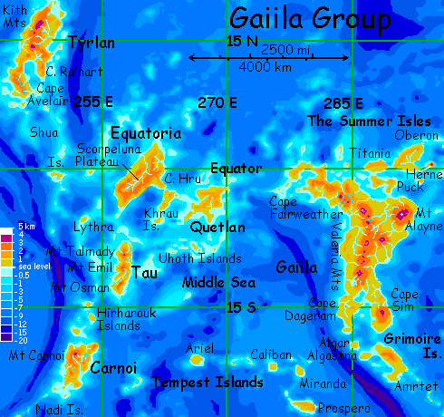
Gaiila's an equatorial cluster containing seven large islands: Gaiila and Amrtet in the east, and Quetlan, Equatoria, Tau, Carnoi and Tyrlan in the west.
The group totals ten million sq km (4 million sq mi), larger than Europe; just over half that is Gaiila, which is nearly 3/4 the size of Australia--one of the largest landmasses on the planet.
This tour covers the next largest island in the cluster, Tyrlan, in the far northwest.
FROM EQUATORIA TO TYRLAN
You start on the western tip of Equatoria, where you've a guest in a treetop koreen village. On the advice of your chattering little hosts, you've been resting up for a full night and day.
You'll need it.
You set out to sea at dusk, flying west-northwest all night. The sun rises behind you, but you still slog along, shoulders aching. No choice--no land.
It's late morning, a good eight hours after you first spread wings and grabbed air, when you spot the islet of Midway and spiral in. Low hills, dense rainforest. Good! Shade and water and fruit. It's hard to land, for you spot no beaches--just low cliffs festooned with trees and vines right down to the tideline. But you clumsily collapse in a tree and climb down. Sleep six hours, get up, find a creek, land in a pool, wash and drink, eat some fruit... and set out again, due west to Shua.
This is starting to feel like work.
Shua's the main rest-stop for fliers on the way to Tyrlan to the north. It's 330 km wide (210 mi); its low hills are a blanket of rainforest. Straddling the equator, Shua has two seasons--warm, rainy orbital winter (when Lyr's further from the sun) and steamy, torrential orbital summer. The only difference is HOW muggy and wet you'll be.
From Shua, the way leads north. You atoll-hop about 500 km per day. The first islets, though low, are still in the equatorial rainbelt, and you find drinkable pools in their forests. By the third day, though, the atolls are still wooded but drier, with only a little fruit to quench your thirst. On the fourth day at sunset, drained and shaking, you reach the coast of Tyrlan.
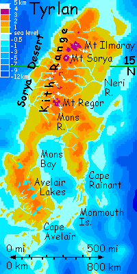
TYRLAN
Tyrlan's the second largest land in Gaiila, bigger than New Guinea--2,000 km long and over 600 wide (1,250 by 400 mi). But Tyrlan's deeply isolated. That long hard flight along the Shuas is the only way in or out. The next-nearest land is Li, in Oronesia, 4250 km to the north (2850 mi). East and west is 10,000 km of deep sea--not a speck of land.
Tyrlan's a whole world--but a world apart. Climates vary: the north straddles a dry high-pressure zone, so the northwest coast is desert; yet the Neri Basin in the northeast is wooded, and the southern Avelair Peninsula is tall monsoon forest. The central Kith Highlands are cloudforest on the east, snowy alps in the center and wild canyon country in the west, where streams descend to the sea every few miles, in deep redrock canyons fed by high waterfalls, 100-500 m (300-1600'). White crossbars on the map mark the biggest, but nearly every canyon has one.
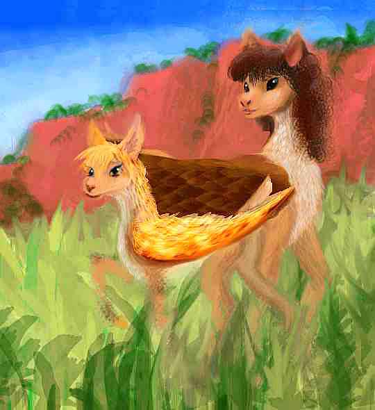
Cape Avelair, where you make landfall, is nearly a separate island 650 km (400 mi) long. Its lowlands are the wettest part of Tyrlan. Behind a coastal strip of sphinx villages, a tall monsoon forest full of koreens slowly rises into cooler highlands full of icari. Interestingly, every sphinx and icarus village has at least a few antel--the highly sociable Equatorian subspecies. Amazing--notoriously shy, herbivorous antel here live with omnivores, even marry them!
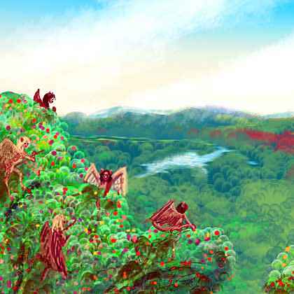
And these icari are more omnivorous than many. Quite a few upland villages look down on mountain lakes, small but deep--the four largest Avelair Lakes are about the size of Lake Tahoe, no more than 40 km long (25 mi). But nearly as deep as Tahoe too; hundreds of meters. And in the clear mountain water, light and photosynthesis and life all penetrate nearly to the bottom. Freshwater fish are a significant protein source for these people.
The lake country is mild in climate, from 1-2 km up (33-6600'); peaks with wooded flanks range up to 2800 m (9200'), capped in alpine meadows. The lake basins are a quilt of antel pasture, berry scrub, and fruit and nut groves. It's a remarkably Terran landscape--if you ignore the angels and flying deer. Oh, and their love of curves and odd angles for paths and boundaries, making this much-cared-for land look half-wild to a merely human eye.
All the next day you ride updrafts north over the lake country, staying in a village on a crag over the northernmost lake. In the morning you skim down the river to the sea, back into lowland heat. But not humidity--this far north, the monsoon forest has broken into mere groves dotting the savanna along the shore of Mons Bay. It's warmer than the uplands, but surprisingly similar. Some koreens and sphinxes, but most of all, antel.
Mons Bay is big--700 km long and 250 wide (450 by 150 mi). Splitting all southern Tyrlan in two, it's a great coral lagoon sheltered by Cape Rainart over the eastern horizon. You skim the shore all day, with no sign of an end.
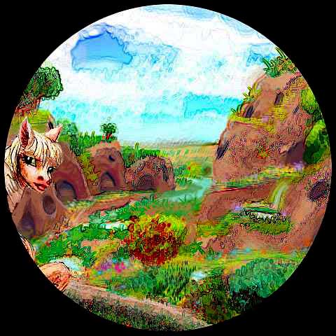
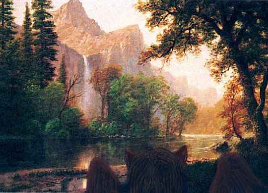
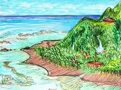
At sunset, an antel on the wing sidles near you and calls "Would you like to stay in our camp tonight?" You're surprised and honored. Your first antel invitation! Following her, you spiral down toward what first seem to be a small arroyo amid low crags. Once, it was--just a cluster of natural rock shelters. But generations of antel added sparing, careful improvements--when your only hands are your prehensile tongues, you avoid heavy construction wherever you can. Of course, that's become their esthetic--boldness, right angles and symmetry are in bad taste, found shapes and local materials are de rigeur. It's not Zen, but Zen and antelity could get along. Small terraces double as landing platforms leading into airy caves, flanking a tiny creek feeding a string of pools small as bathtubs. A lovely place; my watercolor sketch doesn't do its subtlety justice.
But South Crags may be atypical, more openly artificial than most antel habitats, since so many sphinxes live here--fully 10% of the population. The influence may not be so much cultural, but simply the cumulative effects of friends and lovers lending a hand to improvements that handless antel wanted but just couldn't spend the time on (or couldn't do at all, if it required heavy lifting). Is it possible that the antel ideal of beauty is something they can't realize on their own, that the purest flowering of their esthetic comes out only in mixed societies?
Makes you wonder about such issues in human culture--and I'm not thinking of cultural pluralism. That's small stuff! What if all human culture can only flower fully using technology or ideas we don't have yet, and won't, until we incorporate non-human ideas? Picture all the humans who'd have made excellent mathematicians, filmmakers, scientists, pianists... born into cultures with no pianos, movies, metals... with no zero! Sad, huh? Now... what if those wasted souls are us? To the generations after First Contact, how tragically Stone Age we'll look! Such a waste of talent... like a race of brilliant artists with no hands.
Oops! Sorry. End of rant. I promise.

The next day you slowly curve east along the shore, reaching the mouth of the Mons River around noon. North up the Mons, a winding lowland river. But ahead, a white tooth on the horizon grows and grows. Yet for hours the river hardly rises. At dusk you're only a kilometer up, in what look like California hills, with "oak" groves and dry meadows.
You stay the night with a mixed clan of antel and sphinxes; the antel graze the meadows directly, while the sphinxes harvest nuts (the "oaks" have been bred over eons for low-tannin "acorns", producing a staple crop, but the groves contain a dozen other species of nut and fruit trees).
Dinner's not bad, despite a preponderance of berries; they're infinitely varied, some quite spicy.
At dawn you follow the Mons River up into a narrow canyon. The water grows loud and white beneath you. But louder ahead. You round a bend, and above you a great fall looms and roars. Lit orange by the low morning sun, the great cliff generates updrafts most mornings; you wheel near the cliff, climbing patiently. An hour later you're over the lip, amid subalpine meadows below volcanic Mt Regor, 4000 m high (13,100').
It's not a solitary cone, but a trio; on each shoulder, the southern peak has a daughter cone 3-3.5 km high (10-11,500'). You veer west over the meadows and cool blue forests, circling the complex until you can see north. The Kith Range, stretches to the horizon, and beyond: the spine of Tyrlan runs 900 km (550 mi) north.
This west slope is drier, in a rainshadow--open woods, smaller meadows, more bare stone. Below the cliffs is the Sorya Desert, a coastal strip over 600 km long but barely 100 wide (400 by 60 mi). Despite the name, much of SOrya is dry veldt, not true desert, and snowmelt rivers plummet to the sea every few miles, carving deep redrock canyons fed by more high falls. It feels like northwest Mexico, but with a hundred Copper Canyons.
Pueblo tribes would love the place; and as it happens, a similar culture exists here, except that the species in question is floxes, a people like winged canines. They hollow out cliff dwellings in the soft rock, using small fires to crack the stone. They farm the canyon floors, swooping down to their fields and riding thermals back up; but like the Pueblo, they never live out on floodplains. They like a height.
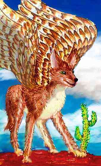
Elsewhere, in forests, floxes will nest high in large trees, hollowing these out as well. But cliffs are preferred, as trees eventually die, while caves last indefinitely. To rid them of parasites, smoky herbal fires are set in burrows to mark each new season (remember, these are fully 450 of the short Lyran days apart).
Floxes are an odd people--in mixed villages, other Lyrans treat them more like pets--fondling, grooming and bonding with them a bit like humans with dogs, loved but not respected: "Floxes live for now, they're not intellectual." And it's true that floxes in mixed cultures still tend to get by on charm and do poorly in school. But consider: they go to school now. Only 800 Lyran years ago floxes spoke in short phrases, and a literate flox would have been inconceivable, while today all floxes speak fluently, a majority can read, and some can do math. Flox skulls over the centuries have grown larger, thinner and lighter, and show no signs of stopping.
Floxes themselves rate intelligence as the most desirable quality in a mate, disapprove of dull floxes having many pups, and will compete for the privilege of adopting smart pups. Hypersensitive to pack standing and aware how others see them, they may thus be directing their own evolution--not out of some abstract sense of racial destiny, but out of a (very canine!) longing to be full, respected members of their new, multispecies pack.
Certainly these desert folk, on their own and unable to slip into dependent, petlike relationships, have built an earthy self-reliant culture you instantly admire--the clean rounded shapes of their caves, doors, windows, plates and pots (they're famed as potters; a lot of clay soils in the Sorya Desert), the circles and spiral motifs they're so fond of.
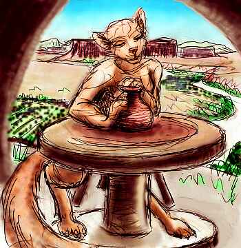 And their rich cuisine, relying on close analogs of beans and sunflower seeds, a plant-stalk nothing like corn but supplying a starchy dough for near-tortillas with a smoky flavor, aromatic herbs, small round berries tasting as hot as chilis, and cheese from large semi-wild herds of winged "sheep" (more like four-legged bluejays, but for all their squawking, they make good cheese)... it all feels startlingly Southwestern.
Those of you who've voyaged through the Ythri Cluster on the far side of Lyr will feel a stronger deja vu--the desert floxes on the Ferranian Islands have an eerily parallel culture. Doesn't seem like chili served in bowls with spiral motifs could be genetic, but...
Well, remember those ancient pots found on the Peruvian coast identical to those in Japanese fishing villages at the time. Storms and currents do carry lost travelers extraordinary distances now and then... though 35,000 km (22,000 mi) is just a little hard to swallow! That's like getting storm-blown all the way around Earth back to your home town. More likely a mad flox potter or chef (or both, on a honeymoon gone overboard) set out to see the world, unaware that Lyr has so much world to see...
Next day you ride thermals north across the mesas, patchy gold and red, broken by green veins of further canyons, more streamfed fields. Antel graze the uplands, hopping from mesa to mesa, following the scarce rains, signaling across the miles by flashing the white undersides of their wings. You're told sphinxes live here too, down by the rivermouths, fishing from terraced crags and trading with the floxes. But you don't meet any up here.
Toward evening, the light hangs low and red, bloodying the mesas, turning the falls a fluorescent, unnatural pink. Above it all, a tent of equally lurid pink snow rises to the east--Mt Sorya, the highest peak in the Kith Range, at 4200 m (13, 800'). It's our signpost; it's time to head inland again.
You spiral down to a hybrid village of antel and flox, half-hidden in the rocks. Watching these deer (more or less) and wolves (more or less) cooking dinner together, playing together, and in a few cases even sleeping together, you can't avoid a certain very Terran gut feeling that this is just too Disney to be right...
You rise late in the morning--and I mean rise, using a sun-heated east-facing cliff's updraft to climb well above the mesas and canyons, and angle inland. Until afternoon, you skirt the Kith Escarpment's fractal edge, past the white plumes of waterfalls. Once the westering sun heats the Escarpment's rocks, the updraft gives you a free ride back into the high country. It really does remind you of Yosemite (or, with its red rocks, a wetter, greener Zion).
Above you looms Mt Ilmaray, nearly as high as Sorya itself, at 4100 m (13,500')--another rugged complex of clean new cones, crumbling old ones, and the sharp shards of still greater volcanoes that exploded. Smashed calderas and concave tricornered horns litter the highlands like shattered pots. As in the Cascades, magma in the Kith Range is relatively thick and full of dissolved gas, so vents here are prone to plugging... and subsequent catastrophe. Maybe that explains the Avelair Lakes too--most are round or oval, and very deep. Calderas flooded after explosions and/or collapses, like Oregon's Crater Lake?
THE IMMIGRATION PROBLEM
As you wander this high, rugged land, so like the cool, pleasant Valeria Range on Gaiila, you wonder why no gryphons have settled here. They're adapted for cold weather and heights; this is warm for them, but probably tolerable.
Then you realize--the nearest gryphons are in Li. On a casual glance at the world map, Li looks like a close neighbor, but its uplands are close to 5000 km north of here--three thousand miles without a single rock to rest on! Lyr's scale has fooled you again.
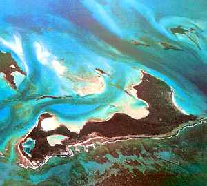
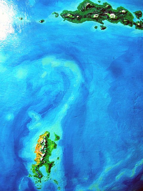
It's fooled a lot of Lyrans too. More than fooled--killed. Writhing north from Tyrlan is a long arc of reefs--crowns of an undersea range at least the height of the Rockies, and perhaps the Andes. But even that's not quite enough to survive the battering of Lyr's relentless surf. Fliers have followed those coral reefs north for centuries, hoping to find islets to rest on, to find shade and fruit and fresh water.
But none have ever been found, and explorers who trusted that lying turquoise path too far never came back. The only orbital photo I have isn't too close-up, but it confirms the grim record of those expeditions: it's a false flyway.

Maybe someday Tyrlan's uplands will have stone keeps guarded by proud eagle eyes--but no time soon. The gryphons of Li aren't likely to develop shipbuilding--for they cling to the highlands even there. The Li coast is just too hot.
It's more likely that their kindred in the highlands of Hrill, the southernmost gryphons in this hemisphere, will eventually risk a colonizing voyage, chartering ships sailed by heat-tolerant soka; at least they have some tradition of this, however faint. Their distant ancestors came this way, at least according to the Epic of Hrill.
But Hrill is 21,000 km east of us! We're not exactly meat under their beaks, as the saying goes...
Not soon.
This side of the Kyth Range is greener, but the canyons are nearly as grand, and the falls, if anything, more thunderous. Instead of creeks dropping separately to the sea, these larger streams collect into a single river, the Neri. Its longest branch is only 500 km (300 mi), but its many arms drain all northeastern Tyrlan. Open, brushy woods with small meadows fill the warm Neri Basin.
It's warm enough for koreens down here. It's rather dry and open for them, but many of their fruit trees will grow along the rivers. Antel herds graze the open stretches; they get along well with koreens, finding these squawky little creatures unthreatening, if loud.
Hmm. What with the sphinxes and icari you've seen in antel villages to the south, and the Sorya Desert antel living with floxes, and this herd mingling with koreens, I fear you're getting a false impression of antel; elsewhere on Lyr, the majority are far too nervous (of course, they'd call it sensitive) to live close to other species, let alone with them--those creatures bite, after all!
But the antel of western Gaiila spread from Ariel, westernmost and loneliest of the Tempest Islands--so isolated it lacked the large predators who make the other Tempests look almost African, and who turned the commoner eastern subspecies of antel into hardwired nervous wrecks (oh, pardon me, sensitive people).
Paradoxical but true: the isolation of their ancestors makes these Tyrlanese antel less isolated now than any other antel race. Had the Tempest Isles arisen in slightly different spots in the Central Sea, their emotions might be different!
Just another example of my overall theme: geography is destiny. But hey, it's OK. I won't ask you to apply this analysis to your own savanna-bred self! Dissecting your own instincts is like doing your own surgery. (And isn't that the real reason humanity hungers to meet aliens? To get a psychological evaluation by someone outside the loony bin?)
Oooh, and I said I was done ranting.
For two days you drift down the Neri Valley, staying one night in the quietest koreen village you've ever heard (to accomodate the antel), and the next night in the loudest, most boisterous antel village... This, too, may be giving you a false picture. These days, most denizens of the Neri Basin live in mixed-species towns along the river-arms.
A merely two-species village? Hicksville!

THE SHUAS
You wake and look out from your treetop hut at the sea: you're on the very tip of Rainart now. It's time to leave Tyrlan. You head south into the Middle Sea again, along the Monmouth Islands. These (as if you couldn't guess from the name) stretch all the way across the mouth of Mons Bay to Cape Avelair. You fly all day, reach Great Monmouth at sunset. It's not THAT great--only 40 miles long--but pleasant. Tall tropical forest full of koreens in the hills, sphinxes on the coast.
From here there's no choice but to retrace our path. Tyrlan really does have only one flyway. It's why there are still so few species of people here, despite the varied terrain offering ideal niches for several more. For four days, you fly back down the Shua chain, through the thirsty zone, and on the fifth day you rest, on Shua itself. You never knew fruit could taste so good!

On day six, you head south into new territory. The first two hours you follow reefs out to an islet where you rest briefly, have a snack. After that it's deep water--azure, featureless, all day. The sun sets, and you fly on.
It's midnight when you reach Lythra. No trouble spotting it--the night, if you can call it that, is a deep azure twilight, brilliantly lit by a full Oisin, nearly four times as bright as our dull and iceless moon.
You sleep right through the next short Lyran day under dense trees, to wake the next morning ready to explore Lythra. It doesn't take long--you've crossed the land by noon. Lythra's only 200 km wide (125 mi), about twice the size of Hawaii. Low hills, tropical forest--not as rainy as Shua, but still lush. Like Tyrlan, it's off the major flyways; the only people you meet are koreens and a few sphinxes.
You spend the afternoon just sprawling on a lovely coral-sand beach and swimming (how good that feels, to use non-flying muscles!). It's a necessary break: to escape Lythra takes a dawn-to-dusk flight too.
The next day you land exhausted at sunset on a modest atoll in the Ziro Islands called Midway (like a dozen others on Lyr). It's obvious why; you're still several hundred km from real land. You sleep in until noon the next day before heading south.
But this final flight isn't as hard. Two more islets break up the journey, and at dusk, the low green coast of Tau spreads before you...

TOUR LYR! The following route snakes around Lyr, covering all major features:
Ythri -- Polesotechnic Chain -- Troisleons -- Roland -- Oronesia -- Gaiila -- Flandry -- Diomedes -- Ak'hai'i -- Averorn
World Dream Bank homepage - Art gallery - New stuff - Introductory sampler, best dreams, best art - On dreamwork - Books
Indexes: Subject - Author - Date - Names - Places - Art media/styles
Titles: A - B - C - D - E - F - G - H - IJ - KL - M - NO - PQ - R - Sa-Sk - Sl-Sz - T - UV - WXYZ
Email: wdreamb@yahoo.com - Catalog of art, books, CDs - Behind the Curtain: FAQs, bio, site map - Kindred sites