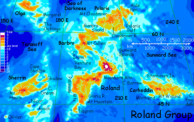
ROLAND
by Chris Wayan, 2006
Lyr (home) - map - creatures - cultures - evolution - climate - geology - gazetteer - nomenclature - definitions - building Lyr - more worlds? Planetocopia!
New on Lyr? First-time orientation--strongly advised! Lyr is weird.
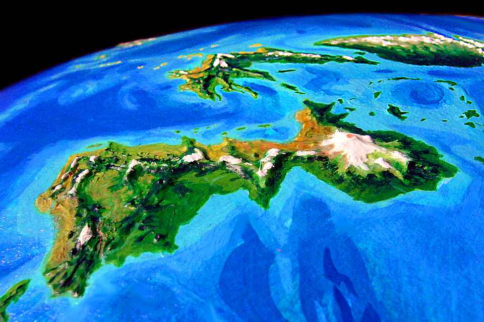
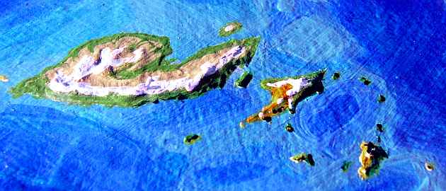
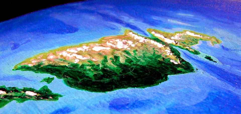
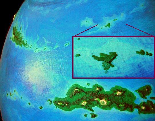
In the orbital shot below, only the cluster's heart is visible: Roland proper in the foreground, Barbro to center left, and Polaris to upper right. A fourth island, Olga, is just visible on the horizon, upper left.
Lyr tilts 36 degrees, so the arctic circle's at only 54 north. Nearly half Roland lies above it, and you'd expect winter darkness months long in the far north; but Lyr's dense atmosphere has a lensing effect, making the sun appear to be above the horizon when it's not--making the effective arctic circle over 60 degrees north, not 54. Winter days do get very short, but only Olga and northern Polaris have a midwinter darkness, and even their long night's punctuated by false dawns every twelve hours. Nor is the cold severe by Earth standards--Lyr's sea is far too big a heat reservoir for that. Still, snow blankets the great volcanoes and often falls at sea level on Olga, Polaris and northern Barbro--a rare sight on Lyr.
In short, by our Ice Age-influenced standards, Roland is cool-temperate at worst. But the winters are still long, wet, dark and cold by Lyran standards, so many winged species migrate to warmer, drier southern islands in winter. Not to the tropics or the southern hemisphere, as on Earth; Lyr is just too big, the flyways too grueling. But the neighboring lands do see a winter influx. Roland's gryphons settled the cool uplands of Oronesia in this way, though many now stay year-round in both locations.
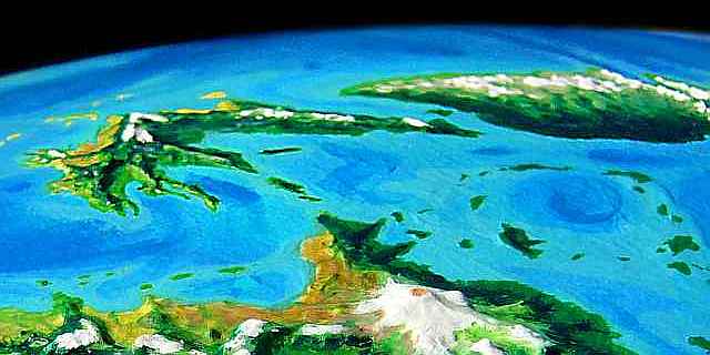
We'll start our tour deep in the Taranoff Sea, west of the Roland group. Taranoff's about the size and shape of the North Pacific. The only islands are the Orfevres (off this map to upper left; see Troisleons), slashing diagonally through the sea's heart. They form a long, arduous flyway from the Troisleons Cluster to...
OLGA
You land on the western tip of Olga at 66 north--nearly as far north as you can be on Lyran ground. It's warmer than Earth at that latitude, but wetter, too--Olga's on the edge of a cold rainbelt like nothing on Earth (see climate belts). The result? Big icefields in the central uplands. From the shore you see only a long sweep of cold coastal steppes up to a white rim. Glacial tongues reach down toward you only to stop a kilometer up, melted in the constant drizzle. The slopes aren't true tundra (the ground beneath isn't permafrost, for Lyr never had an Ice Age), just stony, boggy, sparse grassland.
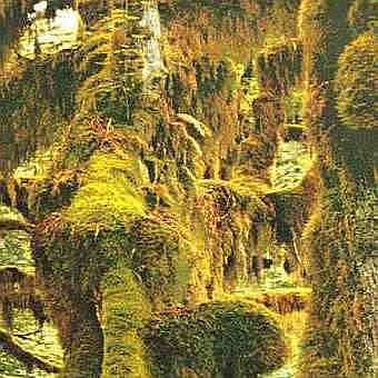
The coastal lowlands are greener but no friendlier--dense tangles of mossy "sleetwood", perpetually cold, wet, and boggy, built on their own rot. Sleetwood is plant heaven, but animal hell--dreary climate, treacherous footing, slow growth, and bitter foliage high in tannins and low in nutrients (the heavy rains leach most minerals out).
As you fly down the coast, you learn to land in the "tundra" and avoid the woods--no safe perches to land on, and tiny black flies swarm in thick, choking clouds. Most creatures fly south for the winter--what creatures there are. You spot herds of chubby marmots with stubby wings, gnawing on grass tufts, and a sort of otter in a pond, but you've flown half a day down the coast before you spot the first sign of intelligent life--three longhouses with sod roofs. The long, graceful shapes look much like upturned boats.
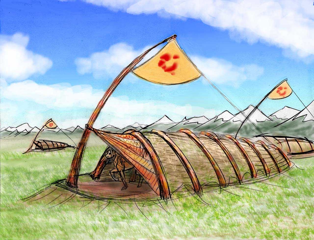
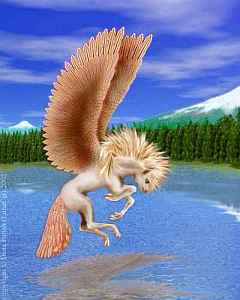
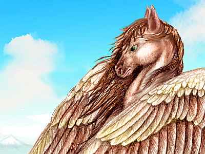
They're full of creatures we can only call pegasi. They welcome you--invite you in out of the wind for a sparse herbivorous lunch. You gawk at your hosts more than you eat. They're not really much like the Greek myth of flying horses--more the size of small deer, and far more lightly built. Their four clever paws are built to pick fruit and grasp tree branches--and tools.
At sundown, four hours later, you find a second pegasus village 200 km down the coast, and sleep in a longhouse. It's certainly warmer than camping--unexpectedly so, since it turns out pegasi sleep in a heap! If you call it sleeping. They drowse, snuggle, squabble, make love, nurse pups and have little pillow talks, all together.
It takes some getting used to, especially since you're not just a witness but a compulsory participant. Pegasi seem to feel that if you're in the heap, you're one of the family...
As pegasi put it, "The family that licks together sticks together."
In the morning, you get up and resume your journey, a little sticky, but feeling much educated. You fly steadily all day east along this bleak coast and spot only three more villages. Olga is big--1100 by 600 km (700 by 400 mi) but sparsely inhabited, even here in the south. The north? Ugh! I'm trying to be thorough about these tours, but I just won't go up there. Glaciated uplands, foothills of sparse tundra, sleetwood lowlands. And the bugs... at least here on the south coast the incessant sea-winds sweep them inland. The pegasi stick to this shore for more than warmth.
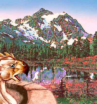
Around sunset you reach Morgarel Point, the southern tip of Olga. Here you're invited to stay in a gryphon keep, like a small stone castle. The largest intelligent carnivores on Lyr, these people really do resemble medieval gryphons--a leonine body with eagle wings and a sharp, hooked beak. Their huge, clawed forepaws make clumsy hands, but do have opposable thumbs. Impressive, dignified, slow and thoughtful, gryphons are the purest, most austere intellects on Lyr. Yet they manage to shock you as much at dinner as the pegasi did in bed. You never miss lips until you see how messy things get without them...
Be polite. The blood will wash off...
In the morning, you set out to sea. A couple of hourlong hops southeast, with a rest on a rugged islet midway, bring you to Morgarel. It's a slender strip of lowland 500 km long (300 mi), mostly bogs and thin forest, with a few steppes on its stony southern hills. Except for the lack of glaciers, it seems much like Olga--a degree or two further south isn't enough to matter. But when you cut south straight across Morgarel, the south shore has true forest, not sleetwood--narrow, spiky sprucelike trees. It's not just a little warmer here, on this south-facing slope, but drier. The chill storms feeding sleetwood come from the north, and the ridge takes the brunt. Both gryphon keeps and pegasus lodges come much closer here--the land's turning almost habitable.
Though most of Roland lies east, your flyway goes due south for a full day, past one low islet to a grassy island thirty km across. These are the first of the Outlings, an island bridge zigzagging east-south-east 1500 km from Morgarel to Barbro. Crossing takes nearly a week. All the Outlings are low rocky steppes with patches of boggy spruce forest here and there. But after chilly Olga, they're paradise.
The mainland of Barbro makes itself known far out to sea: the Cullen Range forms an unbroken, ice-topped wall to the southeast, 2.5 km high (8000'). From afar it looks like Olga all over again--the rim of a large central icefield--but you're under 60 north now. When you make landfall, you find desert canyons marching out of sight to the south, for the Cullens cast a rainshadow. No gryphons here--only the pegasi can make a living, grazing the sparse grass.
To your left is only sea--the Sea of Darkness, the north polar sea, as large as the Pacific, with no land at all--and thus, no base for glaciation. A polar iceshelf does form in the long dark winter, 5-6000 km wide. But it's only a meter thick, and it melts entirely in Lyr's equally long summer. No icebergs--only a little scattered pack ice.
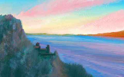
It's a large gryphon keep, of course, not a castle in the Terran sense--not a stronghold for a warlord. The rocky hilltop doesn't provide defense--not on a world full of winged peoples! Just pleasant views and ridable updrafts. Well, there's a third function--a hilltop keep is a beacon, luring in travelers. News and guests are valued in Barbro--it's a vast land, 2000 km long and 800 wide, and this north shore is still lonely, compared to the south.
It takes a second full day to reach the narrows: a modest point, after which Barbro's coast finally turns south. Offshore, you still see only an island to the north, perhaps 30 km wide. The strait beneath your wings has streaks and bands of water suggesting strong currents flowing west. But an hour later, past the island, the northern strait has the opposite. Tides reversing, or an eddy the size of New York? Eyeing the cold, swift water uneasily, you decide this is not a place to go swimming.
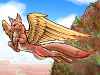
You later learn from some pegasi how wise that was. Lyr's oceans are poorer in nutrients than Earth's, and sea life is on average sparser; but Barbro Strait's fast currents scour up mud, enriching the water, feeding plankton and fish and bigger fish to eat those fish and some real monstrosities to eat those fish. One reason I don't describe Lyr's sea life much is simply that it's not safe to visit. At least three intelligent species are known:
There may even be more. But though a few starnoses do speak some Trade (our limited knowledge of krakens comes through them, for example) none of the sea peoples are really integrated into Lyran civilization; communication is still quite limited.
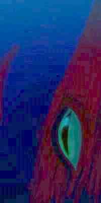
The illustration to the left, showing some common denizens of Barbro Strait, suggests one reason for that. So cross the water above the water. Whatever you do, don't crash. And don't be nervous. And don't think of an elephant... or of a carnivorous marine dinosaur with teeth bigger than you.
Especially don't think about that.
POLARIS
Still, let's say you make it over the strait to Polaris without tooth marks. Is it worth the trouble? I felt no tour of Roland would be complete without at least visiting Polaris, the biggest polar land, fully 2100 km long and 900 wide (1300 x 550 mi)--but we'd better stick to the Scandinavian south. The north gets nasty.
You land on a rocky point and look around. Dark forest runs east and north to a hint of hills on the horizon. More than hills, up there: the Cloudmoor Range is a cluster of volcanoes up to 2500 m (8250') high, glacier-capped, with wide high saddles between, all barrens and stony alps.
Beyond the Cloudmoors, the stormy north shore is solid sleetwood: uninhabitable and imperchable. (Quite a common word on Lyr, imperchable--though pegasi and sphinxes describe people as perchable (or im-) more often than land. They are not talking about sleetwood. So use the word with caution among Lyrans, unless you want to get, um, perched.)
Slowly the dark land rises, the trees dwarf, and the rocky Polaris Hills shrug off their wooded cover. Paradoxically, this poorer land makes better grazing for pegasi--you pass a few lodges in the canyons.
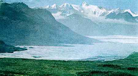
Near sunset, you wind high into the hills. Just as they seem to be rising into serious mountains, you round a bend and... they vanish. The hills drop away in an escarpment, irregular steps of cliff and shelf, to the sea, and on underwater--the sea's so deep it's almost black. You wheel over the abyss and land on the terrace of a gryphon keep, gawking at the spectacle. Across 50 km of dark water, red-lit cliffs glow on the far side--the Alde Peninsula. This is Polaris Rift, a fjord cutting 700 km (450 mi) into southeast Polaris. It appears to be a true rift valley where new crust is spreading, not an ice-carved fjord. The gash can been traced undersea at least 13,000 km (8000+ mi); it cuts straight across Polaris to form a smaller bay on the north shore too, splitting mountains along the way.
Let's not cross the dark water to the Alde Peninsula. It's almost as lonely and harsh as the Cloudmoors--a wedge 800 km (500 mi) wide of tundra-like uplands, snowy ridges, and low woods in the valleys. Spectacular in its Alaskan way, but let's turn south. The rest of Roland is far more hospitable, and I'm tired of being cold.
So next morning, you sail along the cliffs of the Rift, riding the updrafts south. Near sunset you reach a stone keep on Rift Point, where the coast turns west. The next day you feel like you're in the tropics. Inland hills cut this south coast off from the fierce cold katabatic winds that can sweep down the Cloudmoor Basin. This is the first truly gentle land you've seen on Polaris. You fly easily, lazily west all day over coves and points, pegasus orchards and grassy uplands where gryphons herd wingsheep. The second day, you reach Barbro Strait again, which you cross the next morning, and continue south. By noon you reach the Sunward Sea.
South of Mt Cullen is Barbro's warmest region: Cape Irons, a scenic set of clawlike ridges and fjords groping 500 km south into Venture Bay. The capes are low and green but rugged, with many cliffs dropping into narrow sounds.
Including even a few pegasi changes gryphon society. Gryphon clans never made war in the human sense, but they are highly territorial. Reason may say that agriculture and herding allow denser populations, but instinct makes crowded gryphons nervous. Pegasi defuse that tension, much the way dogs relax many humans--providing nonthreatening, noncompetitive physical contact and mutual affection. The three differences are:
Intriguingly, other Lyran societies with two or more species share some characteristics, no matter what species form the mix. Compare with the Aesir Islands in Ythri, Katandara and Larsum in the Polesotechnica Strip, or southern Oronesia. They all seem happier, more vibrant--as if it's just plain fun having other intelligent species around. All the emotional benefits of pet ownership--minus the pets and minus the ownership!
Whether you explored southern Barbro, or short-cut through the Sunward Isles, either way you end up a week later on the north coast of...
ROLAND
Roland's the largest land in the cluster, nearly half as big as Australia. The north is essentially one gigantic shield volcano, Moonhorn Mountain, five km high (16,400') and wider than Olympus Mons on Mars. Moonhorn and its daughter cones form a peninsula bigger than Kamchatka--or an Iceland the size of Spain. Though Moonhorn's icefields are as much due to altitude as latitude. The massif is ice-capped down to 2.5 km or so, with dirty glacier-tongues writhing miles down the valleys. Below, the eastern face has broad alpine meadows where gryphons herd wingsheep, with open woods lower down, thickening to forest on the coast. The much drier west, in a rainshadow, is a tilted grassy steppe, a windy land of ridges and dry canyons where pegasi wheel in the updrafts. Little Edens hide in those canyons, wherever water runs and there's shelter from the cold dry winds off the ice; but at first glance, it's a lonely rawboned land.


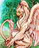
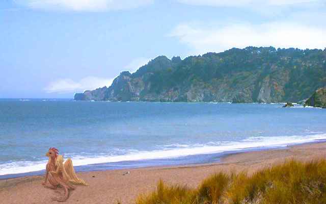
You assumed you'd stay in a pegasus lodge, but near sunset you spot a clifftop village glowing in the sun, overlooking a cove at the mouth of a redwalled canyon. A fishing village? Great seabirds wheel around in the updrafts over the cliffs. No, not birds. Sphinxes! Or as near to the Terran myth as no matter--winged cats with clever paws...
They greet you enthusiastically, with a high-calorie feast of seafood, fruit, nuts and "dairy" products, then a lot of music and partying and toothy flirtation. Don't expect to get more than, well, catnaps, since quite a few curious singles (and a couple or two) will try crawling into bed with the interesting stranger, just to see what happens. It's not quite the puppy-heap that pegasi prefer (sphinxes have claws, after all) but even for human tourists from relatively uninhibited cultures, sphinxes' cheerful crudity can feel a bit overwhelming...
But if you find yourself sneezing from cats in your bed, or pushed into a little more interspecies intimacy than you're ready for, THINK before getting out of bed. If you absent-mindedly step out the west archway of your bedroom instead of the east, it's a sheer fifty-meter drop into the sea. Every sphinx house is carved into rock on the sea-cliff brink, so one can step conveniently into air... conveniently if you're winged. For a tourist who's taken off your strap-ons for the night, it's a deathtrap.
The sphinx invaders in your bed wake themselves up, too. Sphinxes just nap around the clock. And despite their high intelligence, sphinxes' catnapping means they live always on the border of the dreamworld; short, vivid dreams provide advice and complement their logic.
 Perhaps for this reason, sphinx language tends toward metaphor, with strong visual and tactile images. It's what got them dubbed sphinxes in the first place--while they speak fluent Trade and can with effort confine themselves to literal statements (well, literalism laced with humor--no sphinx can resist a joke), to more prosaic species a relaxed, socializing sphinx always seems to talk in riddles.
My advice? Just relax and go with it. They don't expect sanity from you, either.
The next day, another non-arctic species appears. In a canyon two hours south, you spot the distinctive round mouths that mean a flox cliff-dwelling. Now you know you're in temperate country! Floxes can endure cold, even a bit of snow, but their favorite crops don't like it; this settlement's proof winters here are relatively mild. You're leaving Moonhorn's baleful influence at last.
Southern Roland resembles a crumpled pie dish--the rim is the winding Palisade Range, cupping the many-branched Gloria River, some 900 miles (1400 km) long. It takes you three days just to cross the basin. You're in no rush. It's lovely tree-farm country, a quilt of orchards and apparently untouched forest (not really, of course; all carefully tended) laced with small meadows.
It's a quilt of species, too; sphinxes and floxes are common now, along with arboreal pegasi. You keep being fooled by the scale, seeing birds chattering in a modest fruit-tree, only to realize on second look that they're people fruit-picking and chatting in huge trees, with great nets strung below.
Gryphons stick mostly to the heights, but there are still plenty of those: several Palisade peaks top 3 km (10,000'). Tallest of all is Mt Haustein, a volcano 3.5 km high in the far south, near the mouth of the Gloria. The great river's carved an impressive canyon through Haustein's lava flows to reach the sea.
South of the Gloria Delta are the Haustein Uplands--lava flows and secondary cones a kilometer or two high, covered in forest lusher than you've seen. The long flight south across Roland brought you to the edge of the warm-temperate rainbelt. The altitude mitigates the warmth enough so a few gryphons still roam the heights, but most of the people here are sphinxes, pegasi and floxes.
And then Roland just ends--drops to the sea as dramatically as Na Pali or Big Sur. To the southwest is one last volcanic gasp, the Isle of Nagrim, 500 km long, studded with small volcanoes, covered in temperate rain forest. It's as culturally remote from Roland as it is ecologically, for it's a flyway to nowhere. In fact, even flying here to the south coast and looking at Nagrim offshore was a detour we'll have to backtrack from, one way or another.
You do get a choice. A day northwest is the jumping-off point for a flyway taking you straight to the tropics. It's not an easy trip, but if you dive off the westernmost sea-cliff of the Palisades, and fly due west over the sea all day and night and tomorrow morning... you'll probably land alive on Sherrin.
Me, I'm not that reckless. Sherrin's a fascinating place, but it's a lot easier to flap back up past the Gloria Basin to Roland's eastern tip, and island-hop east through the Sunward Isles to the last land in the Roland region:
Carheddin's an irregular spindle shape 2900 km long (1800 mi), and up to a third as wide, mostly low wooded hills but rising in the southwest to the Wolund Range, a chain of dormant volcanoes, two of them over 3 km (2 mi) high. The climate's mild on the coasts, with winter snow only in the hills; a few small glaciers cling to the twin Wolund Peaks. By Roland standards, practically tropical.
It's warm down here, but dark evergreen forests cling to their flanks. Two perfectly matched white cones loom ahead--the twin peaks of Mt Wolund, two miles high (3200 m). This is their shady north side; glaciers snake halfway down, and the creeks pouring into the river turn the strange milky turquoise of a deaf kitten's eye. As you come abreast of the two great volcanoes, the river swings away, down to the coast.
Not wanting to climb the ridges ahead, you follow the stream down to the sea. It's still glassy and calm, painted with dark rainbow plumes of kelp. Out to sea, a flotilla of long ridges--the Starhaven Isles again. They run all the way along Carheddin's north coast--we've not even halfway. Starhaven proper, the largest, in the middle of the chain (still a full day east), is a good 250 km (150 mi) long, but even these much smaller isles sustain lush forest due to the mild, rainy climate.
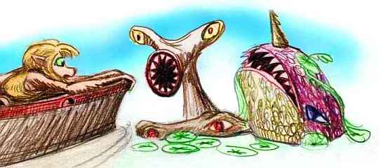
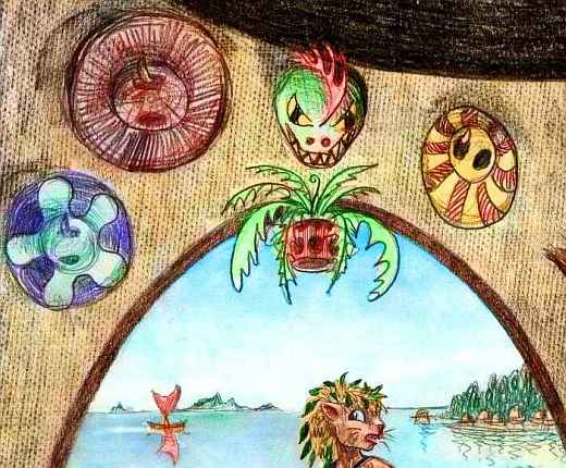
In this sheltered inland sea, a cultural rarity flowers: maritime trade. All along the coast, outriggers with wishbone masts transport goods (not passengers, of course). A couple of port-villages are built right out over the water: rounded bark-cloth houses looking like huge derby hats perch on pilings, while the clan outriggers moor below. Strangely, the people here wear hats, too, the first clothing you've seen; they're inconvenient, of course, since they blow off in flight, but when's logic influenced fashion? Here's a sketch of some festival hats and masks hung by their ear-holes over a doorway. It shows a passing boat, too, with a typical wishbone mast.
Half a day west, the waves grow harsher along the coast--a gap in the archipelago lets the vast cold northern sea through. At the same time, the Wolund Range dips to a pass, and Carheddin narrows. We could continue on down the north shore, for it grows gentle again, sheltered by Starhaven itself. But we haven't seen the south shore at all. So you veer inland, southwest up the next river.

Two hours later you crest the low pass, about 1100 m (3600'), and look down on another world. Carheddin's long south slopes are tilted directly at the sun, and they're much warmer than the latitude would suggest. And exposed to the storms from the rainbelt at 36 north, the land is lush--nearly rainforest. No inland meadows here! A hundred species of tree, of all colors and shapes, bearing unfamiliar fruit and nuts. This profusion isn't pure nature--it's a carefully managed blend of wild and domestic trees. Subtle silviculture.
Lean, lithe creatures hang in the branches, filling wicker baskets with ripe produce--the gracile, shorthaired southern subspecies of pegasus, looking more like winged greyhounds than ponies.
Even the beaches are warm. The Hesperian Sea is almost swimmable. Almost.
As you fly east, Carheddin slowly narrows. The next day, long capes and bays disguise the overall trend; but on the third morning, you're riding the updrafts over a ridge when you're startled by a glint of blue to the north, too. The sea again! You're on Carheddin's many-fingered eastern tip, Cape Engdahl. You sail down it all day, expecting the end at any moment--but the ridges ramble on, in false starts and crooked fingers, for 600 km. But they do end, in sea-cliffs, with open water to the north and a single island south.
Our tour's not quite done, though. The Starhaven Islands continue hundreds of miles, and to reach the next great region, Oronesia, safely, we need to reach land's end. For three more days, we hop leisurely between green islands, resting up for the big jump.
On Last Isle, we camp early and get a good night's sleep--a full five hours. At dawn, we say our farewells to the Roland Group, and fly south into the Hesperian Sea. It's 1200 km (750 mi), a full Lyran day and night, down to the largest land in Oronesia: Li.
Just a footnote--because Last Isle is deceptively named. What most Lyrans call the Starhaven Isles are really just the Inner Starhavens--those on the flyway from Carheddin to Li. Last Isle is just the last convenient jumping-off point for the long haul south. Beyond it lie the Outer Starhavens. They're just as fertile, and nearly as densely settled and farmed; but getting only local traffic, they're a cultural and economic backwater. Pleasant country--subtropical coasts, temperate heights. Where there are any; most of the Outers are low and small.
There's one exception--Salurip, 200-250 km long (125-150 mi). Low hills and plains to the west and north, but a high ridge on the east shore rises sharply a full kilometer from deep sea. Quite a dramatic sight, especially in winter when snow streaks the jagged heights.

TOUR LYR! Climb volcanoes, swim seas, meet weird creatures. First: survival tips! Then, pick a region:
Ythri -- Polesotechnic Chain -- Troisleons -- Roland -- Oronesia -- Gaiila -- Flandry -- Diomedes -- Ak'hai'i -- Averorn
World Dream Bank homepage - Art gallery - New stuff - Introductory sampler, best dreams, best art - On dreamwork - Books
Indexes: Subject - Author - Date - Names - Places - Art media/styles
Titles: A - B - C - D - E - F - G - H - IJ - KL - M - NO - PQ - R - Sa-Sk - Sl-Sz - T - UV - WXYZ
Email: wdreamb@yahoo.com - Catalog of art, books, CDs - Behind the Curtain: FAQs, bio, site map - Kindred sites