SOUTH SEAS
by Chris Wayan, 2006
dedicated to Poul Anderson for his remarkable world-building
Lyr (home) - map - creatures - cultures - evolution - climate - geology - gazetteer - nomenclature - definitions - building Lyr - more worlds? Planetocopia!
OVERVIEW
Two of the five lands in the South Seas have tours already: Averorn and Altai. But the others, all islands in the Dahia Ocean, are still uninhabited and mostly uncharted. A few have been entirely overlooked by the Lyrans. No surprise! The far south is huge, stormy, and with little land; flyways break down here or just end, and shipping's minimal.
Still, that's not the whole story. Lyran exploration's not like Earth's, where nearly every islet (outside the polar ice) was charted before the Industrial Revolution. But on Lyr, even in the well-traveled north there are a good-sized islands still undiscovered--in the northern Alianora and Oronesian Seas and the southwestern Sunward Sea, and three Hawaii-sized islands southeast of Rorvan, and two east of Gaiila, and... well, you get the idea. Poorly mapped oceans are a hidden cost of flight--it's faster than sailing, but with a shorter radius, so islands over 1000 km from known land are likely to stay unknown.
It's not that the Lyrans are lazy. Lyr's seas are just seven times the size of Earth's! Using mere starnose-dolphin gossip and silk charts, they've mapped more surface area (accurately, too) than all our high-tech probes of the solar system combined. And they did it in person, using their own effort and skill... risking their lives with every flight.
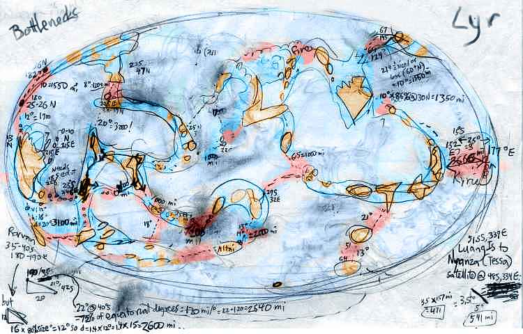
I usually don't show you rough material, but here's my original sketchmap of Lyr's major flyways, calculating their longest gaps--and whether you non-winged readers could fly them in strap-on wings. Land is gold, easily crossable water (up to 1000 km out, and sometimes, in regions with favorable winds, more) is turquoise, and hazardous passages--bottlenecks--are pink. That's a lot of pimples.
The far south is just a deathtrap. That any of it is known or settled at all is a testament to Lyran heroism. They push their limits.
These islands better not hold their breath waiting.
On the other hand, if you stumble on one, you've stumbled on them all! The Dahia Islands and the Borthu Archipelago are close neighbors by South Sea standards: a mere 3700 km apart (2300 miles), with a lone island almost midway. So whether soka or the cheetaurs find the first one (and these two species are the only serious deep-sea mariners on Lyr), they'll claim them all.
Except... one stormblown cheetaur ship did stumble on the Dahia Islands, a century ago, and named many. But claim? They didn't bother. As Gollum used to say: "Not nice placesss."
How not-nice? You'll see.
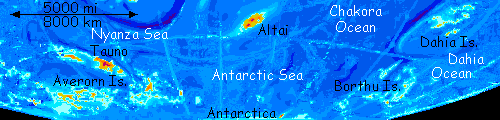
THE DAHIA ISLANDS
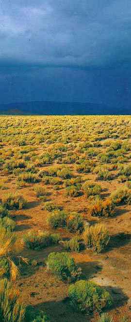
6000 km south of Ikrananka lies a lonely South Sea archipelago called Dahia. All the isles are windy, cool and rather dry. Most are just grassy hills with few or no trees. Maritime steppes! Earth has few equivalents--maybe Patagonia or the Malvinas. The Dahias are around 50 south, on the edge of a belt of dry, descending air that keeps the rains sparse, much like our Horse Latitudes around thirty degrees, where most of our deserts are; but this belt is much cooler. As I explain in Lyr's climate zones, this massive fast-spinning world has more convection cells and cloud belts than Earth; the downside is TWO zones of dry, descending air, two Horse Latitudes--a hot one around 18 degrees north or south, and a cooler one around 54 degrees, centering, unfortunately, right on the Dahias.
Wola, the northernmost large island in the Dahias, is also the most fertile, since it's only in the fringe of the drybelt. Wola is a hilly wedge 180 km (110 mi) long, half of which is two narrow, parallel capes at the east end; North and South Cape shelter the only decent harbor in the Dahias. Wola has a dozen satellite islets, some as big as Kauai or Oahu--three are hundreds of km to the north, and half a dozen form a long chain to the southwest, linking the Wolas to the greater group. Like Wola, they're mostly prairie, but with trees along rivers and in sheltered valleys. Since the northern chain is partly out of the dryzone, you'd expect more woods, and there are scattered oaklike trees in the hills; but those hills are just too low to snag many rainclouds. Wola's ridges do better; the heights have patchy woods on the windward side, and the hills feed some perennial creeks.
The dominant life form is a sort of giant, wingless marmot--wait, that probably sounds redundant to a Terran reader. I mean wingless as opposed to its ancestors, which resembled winged marmots, and are still common in the Averorn Archipelago. Here, in deep isolation, with no natural enemies but hawklike sea-gryphoids, they speciated: their wings shrunk and their bellies grew until today they're as large as a sheep, if not as bright. Flocks of them graze the scrubby hills and gawk at clouds. On Wola, that's culture.
Still, the place has trees and year-round water. It could be settled, if never wealthy. The Eden of the Dahias!
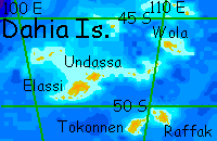
Undassa lies 900 km (570 mi) southwest of Wola. Undassa is larger, some 190 km (120 mi) long. Over a narrow channel to the south is Elassi, the biggest of the Dahia Isles, fully 370 km long and 200 wide (230 by 130 mi). A dozen lesser isles surround them. Though each is bigger than Wola, with taller hills that should catch more rain, Elassi and Undassa are still just grassy hills, with trees only on sheltered hillslopes, for they're well into the drybelt. Only a line of satellite islands to the northwest, as yet unnamed, are far enough north to have extensive riverine trees.
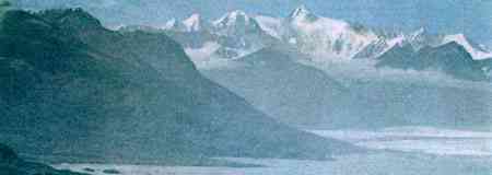
In the orbital photo below, shot near sunset and looking southeast (south pole to upper right--upside-down compared to the map), you can see that the plate on which the Dahias float would be a continent on any reasonable world. But then, Lyr isn't just wet; its tectonics aren't quite Earthlike either. Both the Dahias and the Borthu Islands to the south are patches where the crust seems to be spreading in all directions, welling up like a cloud of cream in coffee or a thunderhead in a Kansas summer.
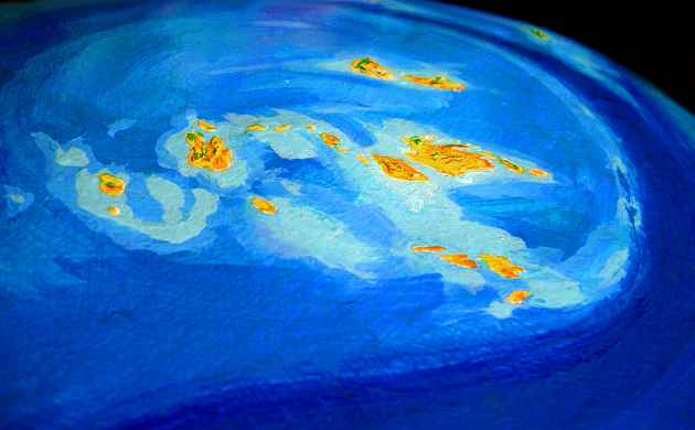
Implosions can be found too--crumpled, puckered basins of infalling crust up to several thousand km across, like the center of the Flandry Group, or the Hisagazi Islands in Polesotechnica. Such round or oval upwellings and downwellings look a bit like the coronae of Venus, though Lyr's are very big. Still, Venus's Artemis Corona rivals anything on Lyr. Coronae seem to happen only in relatively hot mantles and crusts, like Lyr and Venus; presumably it takes a certain flexibility Earth's colder, brittle plates lack. Lyr isn't Venus; many regions have more Earthlike plate tectonics. But several of its hottest zones manifest coronae, while Earth has only one small, debatable corona: Iceland. (For more details on Lyr's tectonic strangeness (including map), see geology.)
The point to grasp here is that the Dahias' chaotic pattern isn't my geological naïveté; that chaos is real, expressing violent Lyrological forces sedate little Earth doesn't face.
But for coronas to breach the surface is rare even on Lyr. The Lyrans, like Terrans, mostly know linear island chains and arcs, following rift and fractures and trenches. They won't expect the chaos of the Dahias either.
Even when a stray cheetaur ship stumbled on the Dahias, it was a mostly-family vessel... and cheetaurs lack wings. They had just two winged scouts--a couple of sokas, who are only short-haul fliers. So they didn't detour far off the line they inferred from the main isles. No reason to infer a Venusian corona!
And they'd have had to detour a long way indeed, for no reason--southeast over 500 miles of deep sea--to stumble on the second largest of the Dahias, which we'll call Tokonnen ("overlooked") in Trade.
Tokonnen's 320 km (200 mi) long, but it's quite treeless, just rocks and grassy hills, except for the central mountains, 1200 m high (4000'), where a couple of endemic tree-species can occasionally be found hiding from the incessant winds in deep ravines. 100 km east is a similar island we'll call Raffak ("Lesser" in Trade--only 220 km /140 miles long), just as rugged and entirely treeless, since its rain-snagging hills are lower. Raffak is just endless dry grass and dull-eyed marmots flapping their useless little vestigial wings.
A true Desert Isle. Curse of the drybelt!
But there are worse things. Oh, much worse. As our mariners will soon find, if they continue south to the isles that you (from your privileged orbital viewpoint) can spot on the southern horizon...
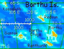
THE BORTHU ARCHIPELAGO
Borthu is a cold, damp, windswept archipelago 3700 km (2300 miles) south of the Dahia Islands. As far as I know, no Lyrans have even found it, let alone explored it. At least none returned to say so.
Borthu never suffers from drought like the Dahias. Soon you'll wish it did.
The northernmost and warmest of the Borthus, we'll call Kossaluth ("livable" or "bearable" in Trade). Perhaps, being merely dull and lonely, not uninhabitable, it should be classed as the last of the Dahias, not the first of the Borthus. It is midway between the two chains. I declared Kossaluth a Borthuvian outlier for geologic not geographic reasons: it rises on a tectonic platelet splintered off from Borthu's chaos, not the Dahia's platform.
Kossaluth is 220 km/140 mi long, narrow and cut by deep valleys and fjords. Boreal forest fills the valleys, but exposed slopes and ridgetops are grassy. Light snow falls, some winters--rare on Lyr at sea level. It's a windswept lonely place, but fertile enough; gryphons and pegasi could settle here, if not exactly flourish. Perhaps they will, someday. It's not that far from the Dahias and might be found by a follow-up expedition--if there ever is one.
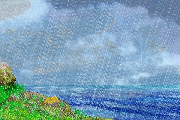
My description of Kossaluth sounds merely Scottish or Nordic, but the rest of the Borthus lie much further south, in the exact opposite of the Dahian drybelt--a subpolar wet zone. Earth has a few cold rainforests, mainly in the Queen Charlotte Islands and bits of southern Chile, but Lyr has a whole belt of this climate. Precipitation levels approach rainforest levels, while summer temperatures average 10° C (50° F)--a windy, wet, miserable ten degrees.
Winters get colder. But no drier. Sleet.
The next of the Borthus, 2500 km to the southeast, is Redsun (pronounced redsoon, and not a descriptive compound--sure, the sun's red here, but no more so than anywhere else on Lyr! Less so, if anything. On Redsun, you never see it. The name just means "Clammy" in Trade.) It's 280 km/175 mi long, narrow and cut by deep valleys and fjords. As windswept as Kossaluth, it's only a little colder, but notably wetter. It snows here in winter, but even now, in high summer, you get fog broken by drizzle broken by squalls. A low, boggy, mossy, impenetrable (terrible footing!) lurid-green forest grows in the wettest valleys--a bizarre community called sleetwood.
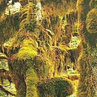
If you've been doing the tours in order, you've encountered this stuff in Averorn, and already know it's inedible, inhospitable, impassable... even fliers find it imperchable. (Quite a common word on Lyr, imperchable--though pegasi and sphinxes describe people as perchable (or im-) more often than land. They are not talking about sleetwood. So use the word with caution among Lyrans, unless you want to get, um, perched.)
We're only on the fringe of the sog-zone. It gets worse.
Borthu ("Shiver") itself is next, fully 300 km (190 mi) long and half as wide. The gnarled sleetwood here's so covered with damp moss it fuses into a chaotic mass of green fuzz. Footing's impossible. The weather's even wetter. And it gets worse.
To the south is Rentharik ("Bedraggled"--well, more graphic than that. More like "A soggy heap of muddy feathers"). At least I assume there's real land there somewhere, under that spongy mass of treacherous moss-bogs and bearded, gnarled, interlocked trees... well, treelike things. You don't look too closely.

You fly the length of Rentharik's central ridge for hours and never see land fit to, well, land. As Mark Twain put it: "The moldiest winter I never spent was a summer in the Borthu Islands."
Thanks for being patient. Just a couple more navigation hazards, and we can go somewhere drier!
1000 km west of Borthu and Rentharik, two immense crags leap suddenly from the sea. Earth has a lone analogue: Ball's Pyramid, between Australia and New Zealand--a misnomer, for it's not a pyramid but a great spire rising nearly 600 m (2000') from deep sea. The Borthu Crags are nearly identical--twin fangs half a mile high, their hard rock narrowed by the relentless sea into impossible needles like some surrealist painting by Roger Dean. Sleetwood, virulent green in the low sun, clings to every ledge. Birds and griffoids wheel, crying.
Let's not even try to visit Gantok ("Hopeless"), another 800 km west. Another rugged imperchable 240 km-wide patch of you-know-what.
No, if we're going to explore the far southern seas, let's head into the heart of it. Set sail south to Antarctica!
Well, southwest. And mind your compass heading. Finding Antarctica, the last unexplored land on Lyr, will take some precise navigation. For south of the Borthus and Averorn sprawl twenty million square kilometers of deep ocean (8 M sq mi, nearly two Arctic Seas) with exactly one island...
|
Averorn Islands - Altai - Antarctica - Borthu Islands - Dahia Islands |
ANTARCTICA
Behold Lyr's south polar cap (photo, below). That's not the mountainous rim of the polar icefield. That's all of it. Antarctica's that small--I didn't even notice this speck at the bottom of the altimetry scans until I happened by with a magnifying glass and found an island I'd overlooked, far closer to the pole than anything else on Lyr. But even so, at 82° south, this Lyran Antarctica probably wouldn't have glaciated down to the sea except for the height of its peak--Mt Cerberus, a three-headed volcano about 3500 m high (11,600'). The peaks iced over, and the ice spread until it mantled most of the island. And yet, many rock-ribs around their knees and nearly all the coastal bluffs are ice-free.
While the name echoes Mt Erebus, Cerberus is really more like the coastal mountains around Alaska's Glacier Bay than Antarctica. In summer, on the coast, it's almost shirtsleeve weather (if your shirt is thick red Alaskan flannel--Cerberus does have glacierbreath after all). But the miserable fogs and drizzles and sleet of the Borthu Islands, far to the north, are gone. Antarctica's in a true polar dry zone--just a milder one than ours. You'll see lichen, moss, even grass in the cracks, sheltered from the relentless wind.
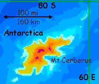
Small though it is, a mere 220 km (140 mi) long and half as wide, Antarctica's influential. It calves icebergs in summer that drift around the south seas, forming welcome perches that have saved many lost and storm-blown fliers. And each winter, Antarctica forms the seed for the south polar ice shelf. For months, the Ice Island swells to truly continental size--until the sun returns.
Here, in summer, standing on the ice-free shore of tiny Antarctica, surround by low grass and flowers, you really start to understand that Earth's never really left the Ice Age--she just put it in polar storage. Worlds with dense air, like Venus and Lyr, have much milder gradients from equator to pole. Just eight degrees from Lyr's south pole, and you could almost sunbathe!

Gazetteer: index of places, with descriptions. Or...
TOUR LYR! Climb volcanoes, swim seas, meet weird creatures. First: survival tips! Then, pick a region:
Ythri -- Polesotechnic Chain -- Troisleons -- Roland -- Oronesia -- Gaiila -- Flandry -- Diomedes -- Ak'hai'i -- Averorn
World Dream Bank homepage - Art gallery - New stuff - Introductory sampler, best dreams, best art - On dreamwork - Books
Indexes: Subject - Author - Date - Names - Places - Art media/styles
Titles: A - B - C - D - E - F - G - H - IJ - KL - M - NO - PQ - R - Sa-Sk - Sl-Sz - T - UV - WXYZ
Email: wdreamb@yahoo.com - Catalog of art, books, CDs - Behind the Curtain: FAQs, bio, site map - Kindred sites