 First-time orientation--strongly advised! Lyr is weird.
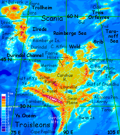
TROISLEONS
by Chris Wayan, 2006
Lyr (home) - map - creatures - cultures - evolution - climate - geology - gazetteer - nomenclature - definitions - building Lyr - more worlds? Planetocopia!
First-time orientation--strongly advised! Lyr is weird.
INTRODUCTION
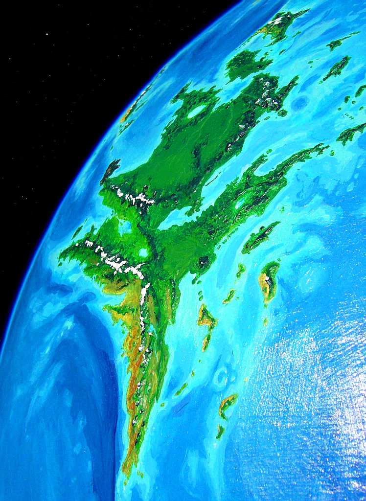
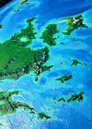
Troisleons is the second biggest continent on Lyr, rivaling Corona itself--11 million sq km (4.3 M sq mi), or half the size of North America. I mention America deliberately--unlike the spidery little not-quite-continents typical on Lyr, Troisleons is the real thing, a maple-leaf-shaped mass with a continental interior, broad temperate plains, a prairie heartland, two great ranges to the west, lower hills and sounds breaking up the east, even a long tapering southern peninsula like Mexico.
In short, it's North America.
True, the Shielding Islands and Scania are barely a quarter the size of Canada, but I bet they seemed plenty big enough if you flew through them... and they're sure chilly enough...
Troisleons is mostly mild and rainy--temperate highlands, subtropical lowlands. Even Cape Alfric, its northern tip, sees a fair amount of winter sun and little snow down along the coast (okay, the hills get blanketed).
A luxuriant subtropical forest covers much of the continent. We only have scraps left on Earth of the ancient forests of China, Europe and America; we cut them down for timber and to clear arable fields. The Lyrans, mostly winged and relatively comfortable in trees, able to harvest the fruits of the high canopy with ease, never logged their woods. They live in them. Why knock down your house?
Terrans, seeing these unbroken woods, may see primordial wilderness. Appearances are deceiving. There's a sophisticated civilization in them thar woods! And not an unprecedented one. It took Europeans centuries to understand that their new-conquered American Wilderness was in fact a carefully managed game park. Troisleons, though it looks equally wild at first view, is just as managed.
AVALON
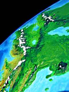
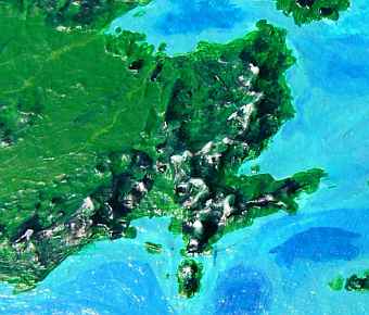
Most tourists will enter the Troisleons region from the northwest, flying in from Thus, your first glimpse of Troisleons is the cliffs of Cape Avalon. It's an impressive debut. This rugged peninsula is a badly eroded shield volcano with a great terminal cliff where the lava flows finally stopped, like Olympus Mons on Mars. It's nowhere near as tall as Olympus's scarps, of course--not in Lyr's higher gravity! But they often rise a full kilometer from the sea (3300').
In sheer scale, then, Cape Avalon is reminisent of Na Pali, the great cliffs on northern Kauai. But instead of emerald rainforest clinging to the cliffs above you and turquoise coral reefs and booming surf below, here dark pines claw at black basalt cliffs, and under your wings, purple kelp sways in the cold green sea.
Rather than climb that formidable wall, you sleep the brief night away on a ledge above the noise and spray (and still, you barely climbed up the great cliff's ankles). Black hexagons of basalt form the ledges, black columns rise above you like drunken skyscrapers... little waterfalls trickle down, to feed hanging fern-gardens. Vertical oases!
After dawn the great cliffs turn out to be a road, not a barrier. The black basalt heats fast, and a breeze kicks up. For hours you ride updrafts, first east, then south, round the indented cape toward the narrow ridge linking it to the mainland. That takes all day--Avalon is 500 km (300 mi) across. But even once the afternoon sun leaves the cliffs in shadow, the winds blow steadily in off Meriven Bay to the east.
Late in the day, you reach the neck linking Avalon to the mainland. You soar above the great ridge as if it's a stone monorail. Off to the southwest is another great blue sheet: the Bay of Ys. You can't spot the green Isle of Ys or the Tarnberg Range on the far side--even on Lyr, 900 km is far over the horizon!
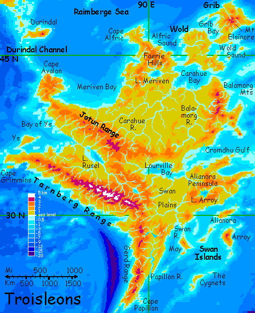
THE JOTUNS
Rising ahead of you are the foothills of the Jotun Mountains. This range is 2700 km (1700 mi) long, crossing the heart of Troisleons, with peaks 3700 m (12,200') high. Overshadowed by the taller, coastal Tarnberg Range to the south, they're still rugged and impressive, and grow more so as you ride their ridges southeast all day. As they climb into the alpine zone, they remind you of the Imric Range back on Scania, and that's no coincidence: they're parts of the same rise.
The Rusel River, draining the great valley between the Tarnberg and Jotun Mountains, is the second longest on Troisleons, 1900 km (1200 mi). It's explosively fertile, since much of its soil is glacial silt from the Tarnberg Range. The land looks Terran.
But not the fauna.
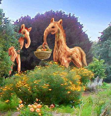
Great giraffe-like creatures browse the trees, giving the country an African look. Yet tall castles dot the valley like Gothic fairytales. Well, a closer look shows they're not castles--cruder shelters with no defensive walls. Barns for domesticated giraffes, does that explain why single-story structures are up to 10 m (33') high? Well... close.
The giraffes are the farmers.
Their common name translates nicely as elaffes, for reasons that become obvious as soon as you see one's elephantine trunk close up, lugging a basket of produce home from her orchards.
Elaffes are a calm, sweet-tempered and trusting people, since, like elephants and giraffes, they never had many natural enemies. Most animals on Lyr are winged, after all, so predators tend to be small enough to fly too. Even in packs, no carnivore on Lyr could safely tackle elaffes.
Sacrificing flight was a heavy price for safety, but the elaffes seem content with their evolutionary bargain. Slow to anger and nearly impossible to frighten, they exude calm and reassurance.
As you wander up the great valley, it feels like the garden of a Zen monastery. You feel scruffy and irritable in comparison--like a yapping, choleric little Chihuahua. Just a few brief conversations with the locals, asking directions, and you're pasting a sappy smile on your face and thinking positively...
Imagine what a longer exposure to their fiendish spell of happiness might do!
Halfway up the valley lies Lake Rusel, shaped like an eye 400 km (250 mi) long; its pupil, Rusel Island, is the largest freshwater island on Lyr--50 km long. Despite Lyr's great size, rivers here are short and large lakes are few. Lake Rusel, in a way, is a remnant of the sea slowly filled up by sediment from the Tarnbergs and Jotuns, analogous to the saltwater sounds of Lourville Bay and Cromdhu Gulf in eastern Troisleons. Its bed is well below sea level. Rusel just happened to get cut off and flushed with fresh water. Hey, it could happen to anyone.
THE TARNBERGS
At dawn, you start into the Tarnbergs. The highest range on Troisleons and the only extensively glaciated peaks, the Tarnbergs reach 4500 m (14,850') near the east end. The range runs a good 3000 km out to Cape Grimmins (1900 mi).
As the sun rises, shadowy purple abysses flame to red--and east-facing cliffs start to heat. You seek out a sunlit face beside a roaring fall, and ride churning updrafts up into another world of pseudo-conifers and alpine meadows.
Tarnberg's rugged, spectacular canyons and waterfalls remind you a bit of Yosemite, though water played more of a role here than ice--Lyr's had no recent equivalent of Earth's cyclic ice ages to sculpt any rocks except in alpine zones. Climate change may threaten many of Earth's natural wonders, but it also created many of them. Lyr's landscape has hyperactive tectonics, but in a way its mild stable climate is a scenic disadvantage! It takes some extremes to create drama...
All day you ride the updrafts--warily, for the thin air (just 3-4 atmospheres, instead of six!) barely supports your heavy Earth bones, and though there's still more oxygen than at sea level on Earth, by now your blood's adjust to a far richer mix; without knowing it, you're severely anemic. Watery orange! You don't need to open a vein to check, just take my word for it. And before you leave Lyr, it'd be wise to spend a few days up here to recover, or in some other mountains high enough to redden your blood again.
At last, near sundown, you slip between two glaciated peaks over a pass of flowering meadows.
On the far side, the Tarnbergs end abruptly--the coast sags here, forming Tarnberg Sound, 300 by 120 km (190 by 75 mi). You ride the winds along the range's flank around the head of the sound. Beyond, the Tarnbergs continue, but now they're a mere neck of hills linking them to the Gerd Mts to the south.
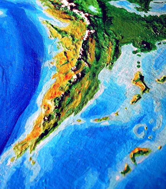
THE TAWNY SOUTH
The Gerds run 1800 km (1200 mi) to Cape Papillon, Troisleons' southern tip. The highest peaks reach 3 km (10,000'). Being lower and more southerly than the Tarnbergs, they acquire a generous winter snowpack but it all melts by late summer; few glaciers here.
Storms here blow in from the east, and the windward shore of Cape Papillon is lush forest, broadleaf at the Gerd's feet but dark conifers higher up; the Gerd's west face is much drier, and cut by short, steep, spectacular canyons.
The long west coast is often called the Gerd Desert, though it's like much of the American Southwest--full of life hidden in the mountains and canyons. Even exposed slopes aren't entirely barren, just dry grass and scrub. But the arboreal northern and eastern natives of Troisleons see this relatively treeless land as uninhabitable. That was, after all, the original meaning of "desert"--any deserted place.
And no intelligent species lived here--until recently.
Soaring over one wide canyon, you spot irrigated fields down near the mouth, where it opens on a savanna plain. You lean into the wind and spiral down for a look. It's a fascinating village built, of all places, on the ground. Low, fluid shapes loping between fields and house, swift as greyhounds.
Ground-based intelligent life? Exotic! First the elaffes, now this. Is this a trend, are wings rarer than you thought, on Lyr?
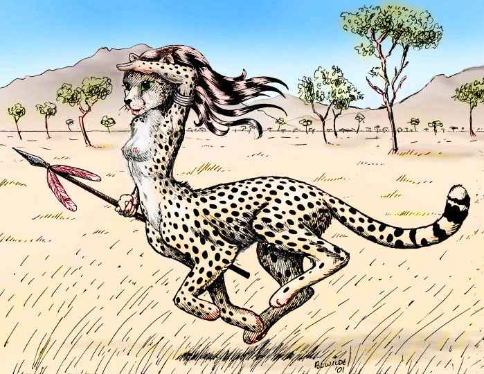
The people are indeed wingless, and a species new to you: cheetaurs, who boated here all the way from Larsum, 12,000 km south in the Polesotechnic Strip. They're built for savanna, and they'd heard from winged travelers about this land and its sunny climate, ideal for them.
Yet they're almost as new here as you are. "We've only been here a century" they say. Though that century is longer than it sounds--cheetaurs have four digits per paw, and sit to count, giving them four hands of four each. They mean sixteen-squared years. And Lyr orbits its sun much further out; winter to winter is almost two and a half Earth years. Do the math. This colony existed a century before Columbus!
Still, for Lyr, that is recent.
Why'd it take them so long to try such a voyage of settlement? Well, cheetaurs aren't built to swim. Being all muscle, with solid bones and no fat, cheetaurs sink like rocks! So sailing is neither natural nor safe. But they'd heard of this land for centuries--hexadecimal centuries. The temptation grew too much. Three ships sailed north, through the perilous equatorial hurricane belt. And the gamble paid off! Cheetaur villages dot Cape Papillon now for 1800 km, especially the more open west coast.
The Gerd Range has no easy passes, so you stick to the coast right down Cape Papillon itself--really two heads and a lovely south-facing crescent bay 130 km wide (80 mi). Out of the rainshadow of the Gerds, the suddenly green hills have groves of low oaklike trees.
ROAD TO NOWHERE
Offshore are some quite Mediterranean islands, lined up neatly and suggestively, pointing like a finger toward distant Polesotechnica. "Go south, young tourist!" Is there an island-chain linking Troisleons and the cheetaur homeland, one they never knew of?
Right here, the tour should have a soundtrack: the Talking Heads, singing "We're on a Road to Nowhere." For those islands are no fluke: a vast undersea mountain range does stretch due south like a crooking finger, all the way to Polesotechnica--a range as long and tall as the Andes, and then some.
Over the horizon a few hundred miles south is a fair-sized island, though the only settlements are a few sphinx eyries dug into the soft rock of its sea-stacks. No cheetaurs live there; a hard day's flight for a sphinx would be a dangerous week-long sea voyage for a flightless cat. Island of No Return!
Further south, a few islets dot the sea; small, but big enough for trees and fresh water: perfect stopovers on the long flight to Larsum.
But the flyway fails. After the first thousand miles, not a peak breaks the surface. A few coral reefs, but no resting places, no fresh water... it truly is a road to nowhere.
And not the only one. Lyr's deep seas often defeat its (quite vigorous) attempts to build land-bridges. Lyran continents, Lyran life, stays isolated, evolving in lonely clusters: Petri dishes in a billion square kilometers of blue. Almost separate planets.
So there's no link to Polesotechnica here. Road to Nowhere! You can only lean left, ride the breeze over Papillon Bay to East Cape, then up the...
SOUTHEAST COAST
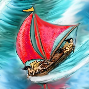
A day or so up the coast from Papillon Bay, you spot a curiosity: a red-sailed boat laden with a ton or two of carved wood panels. It's crewed by a couple of sphinxes. You circle and shout "Where you headed?"
They yell back "Cheetaurs!" Of course. The coastal towns at the dry south end of the cheetaurs' savanna, back around Cape Papillon, lack trees, and need good wood; it's easier to float it in from the wet side of the cape than transport it overland from the hills. These sphinxes will earn a lot of credit for their villages.
Why don't the cheetaurs do it themselves? Remember, they're a powerful, muscular, athletic people... who can't learn to swim. One voyage per century is plenty.
The east coast is rainier, feeding the long Papillon River at the range's base. You find mixed villages, with quite a few cheetaurs but also a lot of skinny little sphinxes and elaffes (both at the southern edge of their range, and adapting to the heat by turning gracile--light and slender. Though I admit "light, slender elaffe" is nearly as oxymoronic as "delicate elephant").
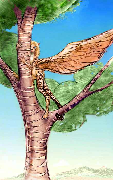
The other uniquely Troisleonian species, baps, isn't found here in the south--they don't mind the heat, but the subtropical sun burns their wing-skins too easily here. Also, cheetaurs can't live with them--baps' echo-location squeaks hurt ultrasonic-sensitive cheetaur ears. Don't worry, we'll meet baps further north...
The next day, in the villages around the Papillon Delta, you notice quite a few funny-looking sphinxes--dappled, lanky, lightly built, long-limbed, almost spidery, swinging in trees as freely as monkeys. An exotic southern subspecies, you assume, until you're introduced to one, and she sets you straight in no uncertain terms. She's a lebbird, and proud of it! Lebbirds aren't even distant cousins of sphinxes, despite appearances. They're an absolutely unrelated species that evolved in the rainforests of Wersgorix, 30,000 km from from the sphinxes' homeland in south Oronesia. Similar environments led to similar lifestyles led to... well, convergent evolution at its most outrageous!
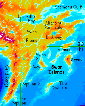
THE SWANS
Just past the Papillon Delta, a line of islets angles out to sea, visible for hundreds of km, slowly receding over the far Lyran horizon. We fly north along the shore for now, but two days later, 1000 km up the pleasant but unspectacular coast, we veer offshore to May. This lovely island 270 km long is just one of thirty off southeast Troisleons--the Swan Archipelago. They range from the rather Mediterranean Cygnets and May to the rainier (but still mild) Arroy, the largest.
Arroy's 360 km (220 mi) long. Steep, volcanic Mt Arroy dominates the island, rearing 3 km (2 mi) above the sea: a temperate Bali. Alianora, north of Arroy, is lower but nearly as large. The Swans are big, beautiful, but too far offshore to explore fully--Arroy is still 800 km east of us, and it's not the furthest out!
The loneliest but most important of the Swans is little Tarou, far southeast of Arroy. Tarou is the only stepping-stone to the huge Polesotechnic Strip to the south--without Tarou, instead of two merely dangerous thousand-mile hops, the flyway'd be a grueling 2000-mile killer--essentially, severed. No lebbirds would grace Troisleon's southern forests, no floxes would fish from the sea-cliffs of the Swans.
Tarou's a pleasant islet--a hundred km of Mediterranean groves and grassy hills--but it's run-down, over-grazed and littered, a classic case of Bus Station Syndrome. Despite deeply ingrained taboos on littering, stripping resources or fouling water, travelers passing through Tarou are just too exhausted to clean up diligently--though most try. But the isle's too small for their sheer numbers. Even conscientious grazing and fruitpicking and camping take a toll.
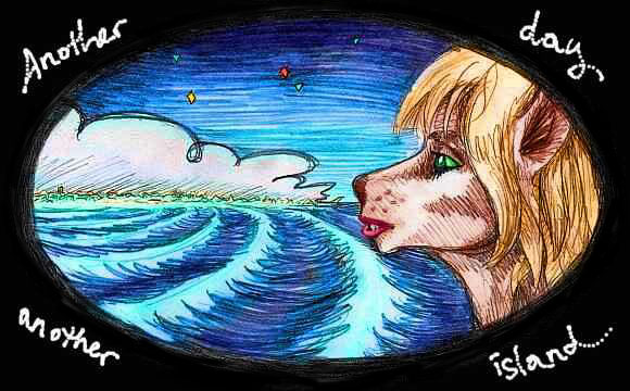
Let's not visit and say we did. You must have had enough island-hopping on this tour (and more to come! Of course it's hard to avoid, on a world that's 95% sea...)
THE GREEN EAST
Rather than wander the Swans, let's follow the Northern Mays, a small chain leading back to the mainland near the mouth of the great Swan River.
This slow, winding, manybranched stream rises in the snowy Tarnberg Mts to the west. Glacial silt from the range has created the Swan Plains, 800 km (500 mi) wide--one of the largest flatlands on this rugged, active, flooded world. It's warm temperate forest with small meadows here and there--mostly clearings for sunloving specialty crops. Notice I said specialty crops. All the staples of the local economy are tree-crops, scattered among wild trees to reduce pest loss. What do they grow? A dozen fruits and seeds up to the size of your head--the seeds fall in three broad groups bred for protein, oil, and starch, roughly equivalent to our soybeans, nuts, and grains.
The plain's densely populated farm country, but its bap tree-villages are as invisible as the crops. So are the treetop villages of mixed sphinxes, lebbirds and pegasi, until you fly right overhead. Only the tall, thatched roofs of the elaffes' castle-like dwellings stand out in the dense forest, like grassy Mayan pyramids.
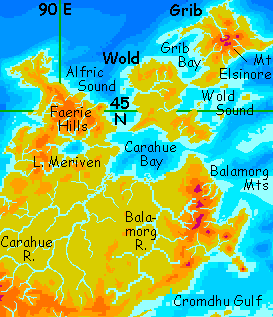
Let's curve east into the Alianora Hills. They hide a gem--Lake Arroy, largest in eastern Troisleons. It's a rough oval 160 km (100 mi) long. The Arroy River is short, only 1150 km (720 mi), but has a huge flow--the Hills are rainy country. You glide down the river valley until it turns south toward the sea; but our way lies north. Over the hills lies a silver sheet--not another lake, but Arroy Bay, an arm of the Gulf of Cromdhu. This great sound east of Troisleons is over 2500 km (1500 mi) wide, as big as the Mediterranean. The shores are rugged but green; the climate, mild and rainy. The "dh" is a voiced th, as in "this".
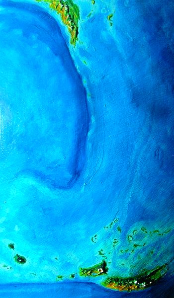
We're between two rugged, narrow fingers clawing into the Cromdhu Gulf: Cape Arroy due east of us, and Cape Alianora to the north, each nearly 500 km (300 mi) long. But we've a long way to go; we can't follow them out to the tips, scenic though they are. And where would we stop? The Cromdhu Islands extend out for 1000 miles and more--huge sea-cliffed stone dragons, long, narrow, sinuous, rugged, and lush. They're off the mini-map above, but they sprawl across the lower half of this orbital photo; Lake Arroy is just visible, lower left edge. "Pine" forests onshore, "kelp" forests offshore! Rich fishing for sphinxes.
Scale? The Cromdhus are huge--two are 600 km long (380 mi). We simply don't have the time. No need, anyway--a stream of travelers (happy to tell you tales and show you sketches) pours off Cape Arroy, for it anchors the flyway from Tarou and the Polesotechnic Strip to the south. Though it's a difficult route, traffic is heavy--these two regions are large and fertile, with high populations.
Our way lies northwest at first, across the base of Cape Alianora, then west along the Gulf shore, past hilly green islands and sounds.
It only takes half an hour to cross the strait. Two hours of low green hills, then Lourville Plain, a wide, wooded valley. On the northern horizon, across the plain, are much higher ridges--the cloud-wreathed Lourville Hills, up to 2000 m (6600').
UTOPIA
There, in a foothill town, you find a music inn, that ubiquitous Lyran institution. A quartet from the northeast called Balamorg is playing. Plaintive, changeable music with curiously fatalistic, wry lyrics--you hear hints of Appalachia, but even more, some harsh, stony echo of New England. And there's some truth to that, for they're named after their homeland, the Balamorg Mts of northeast Troisleons. Two miles high, snowy, rugged, dark-forested, mist-wrapped, famed for treacherous weather... have they shaped this music, its toughness, its fatalism?
Well... maybe. In the morning you hike up among rock, seeking a sunny spot, and find someone's beaten you to it--one of the musicians. You talk and flirt a bit (with a sphinx, the flirtation part is unavoidable, regardless of your age, gender, sexual orientation, or species. Sphinxes are loyal graduates of the anything-that-moves school). She's of the rangy little delicate southern race of sphinxes, kittenish and cheerful. "I flew north because of that Balamorg music. It spoke to me. So much deeper than the stuff at home!"
Home, it turns out, means the Swan Isles--her clan are fishers and orchardists on Arroy. She talks as if Arroyan music were as syrupy as may-wine. Maybe it is. What if the sheltered, ordered worlds of mild volcanic islands like Hawaii influence the music? Certainly some of the stormiest Terran music comes from German and Scandinavian composers... Okay, no one's going to like that theory--inspiration is really bad weather? Besides, what of hurricanes, or Hawaiian villages getting 6000 mm of rain a year?
But it's a fascinating backstage look--this young, coltish music student happily sprawled on the rocks like a cheetah, and the eerie singer last night... the same sphinx. People, like planets, have many faces! If my tour of Lyr seems too sunny or bland, remember, it's only my tour: my face. A dark, moody tour guide could show you a darker, moodier Lyr: bloody-minded gryphons, grotesque hexanauts, monstrous krakens, deadly sea-passages, and poor hardscrabble lives. They're all here, though the suffering's perhaps less universal than present-day Earth's. I just lack a taste for darkness these days. Force-fed a bit too much of it in the news, I guess.
Though there's a practical reason the Lyr I show you has to seem unnaturally optimistic. By their nature, these tours can't show you all of Lyr. You're a tourist in strap-on wings; you can't fly like the locals. I have to restrict you to the easiest routes available. And that means major flight routes and airport hubs!
Of course it all starts to seem fake--low technology, yet amazingly well-traveled, well-informed people living in a tolerant, multi-species paradise. A fantasy? No, a biased sampling method! There are plenty of lonely corners of Lyr, far off the flyways, that are unappealingly backward--hungry, poor, lonely, stagnant... losing half their cubs to the flyways. Or they're simply unpopulated, like the dreary Borthu Islands. But half of Lyr's dystopian patches require long, exhausting dead-end detours (and I do mean dead, as in "tourists trying to fly back out against that headwind kept drowning, so scratch that tour,") and the other half are places you couldn't even reach to get trapped in...
The winged nature of Lyran travel, then, means that our coverage has to be exactly the opposite of Earth's: happy lands make the news! And is that unfair? Remember our judgment is biased too. As human life expectancy climbs and the percentages suffering from hunger, illness and violent death all drop, it's always the festering exceptions we hear about. Apes love a crisis. Poor old monkey readers, looking for reasons to feel superior to the locals! Or relish a good vicarious war. You could go rewatch Avatar. Now there's a furtopia with the essential elements restored: Marines, and buckets of blood.
So I think I won't apologize after all for the sun, the fruit, the music-inns... the peace. Live with it.
In fact, let's go meet another sort of musician.
Our flyway heads inland, not out toward Balamorg. You follow a creek--most streams here in eastern Troisleons, from the Lourville Hills beneath your wings to the steep white creeks of the Balamorgs, flow inland, collecting into the great Balamorg River, sprawling and looping over a plain 1000 km wide (over 600 mi).
And this vast flat, dwarfing the Swan Plain, is only a third of the whole. Over the low hills to the northwest sprawls the Carahue Plain. The muddy Carahue River, 2600 km long (1600 mi) is the second longest in the world (after Ythri's Farview River) and drains by far the largest basin on Lyr--the Carahue Plain, over a million square miles in the heart of the temperate rainbelt. The plain's huge mossy trees resemble the Olympic Peninsula's rainforest except that many of these giants are broadleaf, and they march on for 1600 km (1000 mi).
At Carahue's center is the farthest point from the ubiquitous sea--800 km (500 mi). Not the farthest on Troisleons--on all of Lyr. The continent of Ythri is a little bigger than Troisleons, but more spidery and maritime--it has nothing like the Carahue Basin. Like our Amazon, it's continental, its own world, generating its own climate.
Who lives here? On the ground, of course, a scattered population of elaffes... but in this rainforest, the real action's in the canopy. This is the ancestral home of the baps.
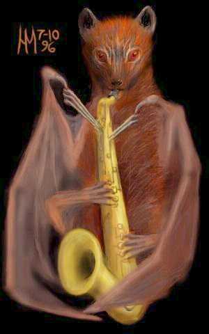
ON BAPS
These aren't bats like Grandma used to make! Baps have a 3-meter wingspan, excellent eyes, and an omnivorous diet including a lot of fruit. Like most Lyrans their body-plan has six limbs not four, so their dexterity and locomotion on the ground (and more to the point, in trees--they're a rainforest race, after all) far surpass any Terran bat.
So do their brains. Bap brains are superefficient--no larger than a dog's, yet capable of language, math, ethics, free verse and syncopation. Lots of syncopation--baps are obsessed with jazz. Well, they don't call it that, of course--their name is ziZIIIII' (a painful squeak followed by a much more painful squeak). But all the elements are there--improvisation, dense chords, syncopation, small combos in which each musician solos in turn. Even the scales are similar--not tempered quite like ours, but roughly Dorian and Mixolydian, with a flat seventh.
But the bap sense of time is twice as fast as ours, and high notes climb into the dog or dolphin range--so it all sounds like The Chipmunks trying to be beatniks. Bapniks? Vocals range over an average of five octaves (a good singer can manage six!), and are competitive--for singers are out to impress possible mates, and occasionally push things beyond what even a bap could strictly call musical, into, well, showing off.
It should be here noted that some bap astronomers claim that the mysterious substance gluing the galaxies together isn't "dark matter" but "showing off." Fits the criteria--sticky, icky, and everywhere.
Anyway... by day you flap patiently a bit west of north, over the dividing hills into Carahue Basin to the river's wide delta. By night you listen to squeaky creaky jazz, and don't get enough sleep. By the time you reach Carahue Bay you're so punchy you keep closing your eyes and trying to echo-locate, like your hosts...
ON FISHING THE HARD WAY
Baps are a minority in the Carahue Delta and the shores of Carahue Bay. Here, Sphinx villages dot the coast, because the sound, 800 by 500 km (500 by 300 mi) is such a rich fishing ground--the Balamorg and Carahue Rivers dump megatons of mud into it, and the Isle of Wold shelters the bay to the north, making it unusually warm for this latitude.
Though the land's cooler than it looks. The fern-trees common here, and the little inlets choked with waterlilies, look quite tropical, but the land heats up only in the midday sun; mornings and afternoons are often a bit chilly. Farewell, subtropics...
For an hour or two you ride the seabreezes north along this shore, watching the sphinxes dive for fish. Don't try this. No, really, do NOT try this! I know it looks fun. You are not a pelican, not a sphinx. You are a tourist in cheap strap-ons, barely competent in the air and not at all in the water. Do NOT break your wingstruts AND both arms AND then drown in the wreckage. Thank you. No more dead readers, okay?
Let's head inland, away from recreational temptation. Veer inland, over the low hills. Surprise! A shocking silver sheet of sea--the west coast? Is Troisleons that narrow?
No. Swoop down the long slopes to the shore; it won't take more than half an hour. Land on the beach and peel off your wings. Stretch. Notice the gentle little wavelets. Wade in and taste that water. Fresh!
This is Lake Meriven, the largest in northern Troisleons--a true Great Lake, on the American scale--an oval 200 by 300 km across (130 x 190 mi), nestled in the Faerie Hills. Big enough to fool you! Understandable, given Lyr's fractal geography. Damn near every gleam you see does turn out to be that relentless ocean, poking its nose in everywhere.
But Troisleons is the exception--a continent that, well, continues.
North of Lake Meriven rise the Faerie Hills, a chaotic knot of ridges up to 2000 m (6600'); streams run every direction, though most eventually collect in Lake Meriven. Here Troisleons really does narrow at last, ending in Cape Alfric, a rugged tongue sticking 700 km (450 mi) into the cool northern sea. A forked tongue--all fjordlike bays and heads, cliff-lined. Harsh but beautiful. Still, it's a long detour, and similar to Cape Avalon, which you've seen; let's not go and say we did.
So instead, you merely follow the broad Meriven River down from the lake back to the coast, and flap northeast over endless orchards, punctuated only by elaffe barns and bap tree hamlets.
Carahue Bay reappears to the southeast, and you slip along the coast for another hour to blue Alfric Strait.
WOLD AND GRIB
Farewell, Troisleons! Sort of farewell. The Isle of Wold may be called that, but it still feels continental. Crossing it, the land looks familiar--orchards and elaffe barns prove their ancestors rafted the strait long ago. You flap on and on, over gentle orchard-hills. Take your time. Wold stretches 1400 km (800 mi), and even crossing its narrow waist from Alfric to Grib Strait is a long two-day trip.
A damp one. Summer weather here's as rainy as Britain (though winter freezes are much rarer). The sun's mild, but afternoon showers are common.
On the third day, you cross Grib Strait. Grib isn't really much further north than Wold, and for the first day it seems similar. But after you leave the relatively warm southwest peninsula forming the strait, climbing into the south-central hills, it feels northerly. Just as damp as Wold, but more exposed to storms off the Taranoff Sea, and while winter freezes are still rare in the southern lowlands, much of Grib is wild piny uplands that thaw only in late spring. Brooding over these austere forest ridges are glaciated peaks like the volcanoes of the Cascades. The most impressive is Mt Elsinore, a volcanic cone 3100 m high (10,300'), resembling Mt Hood, or Fuji.
By now you know Lyran ecology well enough to guess that elaffes flourish only in far southern Grib. The rest of the great island, larger than Britain, is gryphon country, except for the drier west coast. There, in the rainshadow of the Elsinore Range, the dark trees fail, exposing windy prairies and heaths, dotted with the lodges of pegasi--the large, shaggy, well-insulated northern race, like Icelandic ponies with wings (and hollow bones). They graze on these meadows and berryfields. Can't quite call it farming, but it's not simple gathering either, of course, since they tend their land carefully. Auto-pastoralism--be your own sheep! Well, clever, talkative, aerodynamic sheep.
THE BRIDGE TO ROLAND
... isn't easy, since there is no bridge to the Roland Group--if you click the link, you're cheating. You're here to see how the Lyrans do it, and the answer is, with difficulty. It's a cold, stormy passage bracketed by two dangerously long flights, and you're facing the first--1200 km (750 mi) northeast over cold deep water to the Orfevre Islands.
You fly 14 hours nonstop, a full day and night and two hours into daylight again, before the black cliffs of Yve rises into view and you glide in to the stony beach.
You sleep all day and all night, wake, eat, and sleep another full day and night (of course, on Lyr that only adds up to about one Terran day, so let's not get too dramatic) before you even feel up to exploring.
The archipelago's full name is Les Trois Orfevres, the Three Goldsmiths. A misnomer--there are three big islands, Odo, Gui, and Yve, but plenty of little apprentices. Cool, windy, dark-forested east-west ridges rising in cliffs from the cold sea. Even the big three are narrow--the sea's always there, waiting.
We won't be visiting the one exception, Gui, westernmost of the Orfevres, for it's off the flyway to Roland. Gui ("ghee", not jee, gwi or gway--blame a Francophile cartographer for these names, not me) is a shield volcano 2400 m (8000') high, forming an oval island 450 km (280 mi) long. Gui is pine-forested, except on the bleak windy uplands around the peak and stony canyons on the west side. Yve and Gui are in a drybelt, and Gui's high glacier-mantled central peaks cast a rainshadow, creating a cool desert in the west. It's a desolate, windy place, but really, the prairies and woods around it are almost as lonely. A few gryphon keeps, that's all.
Our way runs northeast instead, up the spine of Yve. You quickly learn to stick to the windward face of the long ridge, where the steady winds off the cold Taranoff Sea to the east create ridable updrafts--a standing wave 750 km long! Besides, the western shores are long, bare grassy ridges. You ride the great wave all day, guest in a gryphon keep that night, and ride half the next morning too, to the end of Yve. You lunch on the final beach with a family of gryphon travelers, who feed you sushi. You're grateful. You're especially grateful it wasn't anything covered with blood.
You chase the gryphons all afternoon, hopping northeast from islet to islet... but you can't keep up. Strap-on wings and human muscles, are no match for hawk-wings. You sleep alone on a piny crag like a castle whose moat is an infinite gray sea... At least there's drinking water. All this persistence has sped you right through the drybelt, almost before you even noticed it. You're entering a zone Earth (mostly) lacks--a subpolar wet belt.
Here the islets end and the flyway bends nearly due north. It's five hours to the first satellite of Odo, in the northern Orfevres. A low, bearded, tangled forest atop green cliffs. Yes, even vertical cliffs are moss-streaked, it's that damp here.
Odo itself is a couple of hours further north--deep in the wet zone. Mossy, boggy, treacherous ground, not really safe to explore. It's a single cloud-wreathed ridge 500 km (300 mi) long, pointing still further northeast.
Although there is a line of islets out there, you paid attention to those gryphons on the beach. They warned you the line dead-ends in a stormy gray sea. The true flyway is due north to the line called the Apprentices, deeper in the wet zone. Reluctantly, we follow their advice, though it's a cold, miserable ordeal: the Apprentices are nearly as cold as the Aleutians. Drizzle and chill fogs are broken only by occasional blue skies over the sea; clouds wrap every single island's summit. You're never quite dry or warm or rested. A bone-deep fatigue sets in; you feel heavier than in the sunny south...
That's no illusion. You are heavier. Lyr spins twice as fast as Earth, and its light materials let its equator bulge more; Lyr's nearly as oblate as Saturn or Jupiter. You're closer to the center of mass near the poles, and there's less centrifugal force to lighten you. Even on Earth, you weigh perhaps half a kilo extra at the poles; but on Lyr the gravity creeps up from 1.23 G at the equator to nearly 1.4 here in the far north. You sag in the air like a plane dragged down by ice building up on its wings--but this weight can't be shaken off. It's in your bones.
And the flyway gets worse.
The islets shrink to rocks.
Reefs.
Shoals.
Rest up on your salt-crusted, windy rock! Ahead you'll find nowhere to rest. It's a grueling nonstop flight of 1300 km (800 mi) over the chill Taranoff Sea to the outlying islets of Olga, in the next great continental cluster: the Roland Group.
But there's a silver lining. At least (as you shiver in exhaustion and cold and fear, wondering how close you are to being one of the many annual fatalities on this flyway) at least you get a few patches of sun, now that all that pesky, cloud-attracting land is gone...
TOUR LYR! The following route snakes around Lyr, covering all major features:
World Dream Bank homepage - Art gallery - New stuff - Introductory sampler, best dreams, best art - On dreamwork - Books

 The shoreline even starts bending south a while, but at last land appears across the gulf, on the northwest horizon: The Lourville Peninsula, our bridge to the north. West of this strait, the gulf narrows to an inland sea 1000 km long and 300 wide (600 by 200 mi), called Lourville Bay.


Ythri -- Polesotechnic Chain -- Troisleons -- Roland -- Oronesia -- Gaiila -- Flandry -- Diomedes -- Ak'hai'i -- Averorn
LISTS AND LINKS: more worlds? PLANETOCOPIA! - dreams of other worlds - ecology - climate change - evolution - populations and eco-crashes - anarchy - utopias - natural disasters - terraforming - orbital dreams - sculptures and 3D art -
Indexes: Subject - Author - Date - Names - Places - Art media/styles
Titles: A - B - C - D - E - F - G - H - IJ - KL - M - NO - PQ - R - Sa-Sk - Sl-Sz - T - UV - WXYZ
Email: wdreamb@yahoo.com - Catalog of art, books, CDs - Behind the Curtain: FAQs, bio, site map - Kindred sites