World Dream Bank
home -
add a dream -
newest -
art gallery -
sampler -
dreams by
title,
subject,
author,
date,
places,
names
WELCOME TO SEAPOLE
by Chris Wayan, 2002
One of a series of alternate worlds created by tilting Earth's axis,
exploring climatology, evolution, and cultural geography.
Climate - Map - Ornithia - Amazonia - Caribbean - Gringolia - Siberia - Europe - Africa - Arabia - Asia - Roo - Biology - Culture - Lessons
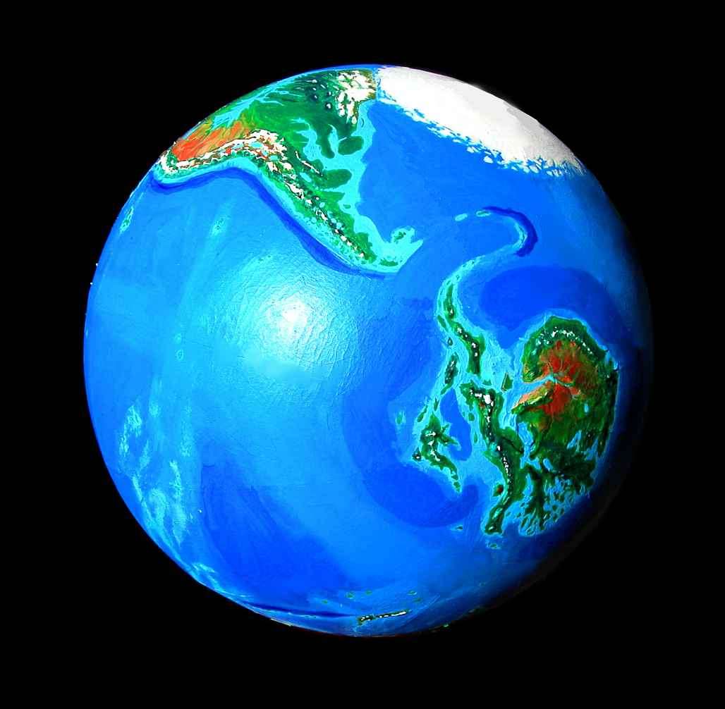
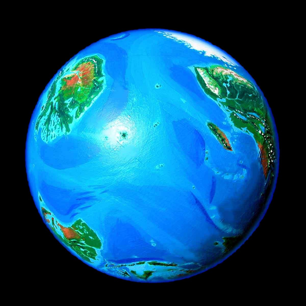
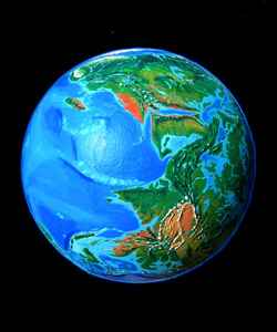
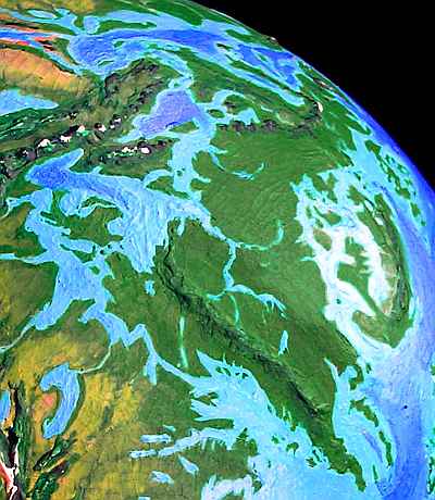
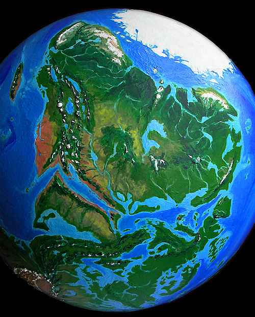
As an experiment, I took an Earth globe off its stand and tilted it until both poles were oceanic, like our Arctic. That wasn't easy! With our current geography, nearly all possible axes have one wet pole and one dry (quite by chance--in many geological eras, it wasn't so). I only found two "wet" orientations--this one, with poles in the South Atlantic and off Japan, or poles in the Arabian Sea and south of Mexico. Here's an orbital shot of the "north" pole I chose, with the icy mountains of Brazil at upper left and the cool boreal forests of Africa on the right.
 With no land near either pole, there's no Antarctic ice dome, not even a Greenland. With almost none of the world's water locked up in thick ice, sea levels are 90 meters higher (nearly 300'). The weight of that extra water on coasts and continental shelves presses them down, just as glaciers during our Ice Ages depress the land beneath them. This slightly exaggerates the coastal flooding (though continental interiors bulge up a bit to compensate)--the result is an effective sea level rise in most places of about 100 meters (328'). Sound like a lot? It is, and we may learn that the hard way in the next few generations--see Dubia, a model of Earth 1000 years from now, after full polar meltdown.
World climate is much warmer and wetter, especially toward the poles. While they're still icy, temperatures above 60 north are more Alaskan than Antarctic or even Greenlandic. In severe winters, this northern ice pack occasionally forms a bridge between Brazil and Africa; in hot summers, the pack may briefly break up into bergs, which our Arctic pack never has (so far; it may soon). My point is that sea ice is thin and changeable compared to land glaciation. This icepack looks impressive from space, but it's skin-deep; Seapole has only 1-2% of Earth's ice by volume.
What happens at lower latitudes without icecaps breathing down their neck? The high sea levels dominate climate. Instead of fertile coasts but harsh continental interiors, nearly all of Seapole has maritime climate--for the sea is everywhere. Perhaps 20% less land than Earth! Rainforests and savannas; few deserts. A warm, flooded, jungly world.
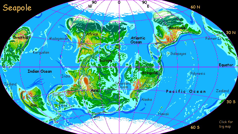
Here's a map showing the tilt, the flooded coast and new inland seas; it'll help orient you, too. Or disorient you! Does it all look distorted and moved around, like a map of the breakup of Pangea? It's not continental drift--these are our continents (a bit flooded and damp, but basically undamaged) in exactly the same layout! But mapping round Earth on a flat sheet distorts it terribly--you're just used to the conventional map's polar distortions. This map's just as accurate--but its distortion's unfamiliar. Visual habits are powerful!
The meridians run from the new poles, of course, but the Prime Meridian (the centerline, longitude zero) is still Greenwich, England. Yep, that little green archipelago just above dead center is England, upside down and flooded. That's Scandinavia beneath it and the similar big island to the east is Greenland--rightly named at last! I renamed a few continents--having North America south of South America seemed a recipe for confusion, for example, and Australia and Antarctica's names are just Latinized terms for their Earthly locations.
 Climate - Map - Ornithia - Amazonia - Caribbean - Gringolia - Siberia - Europe - Africa - Arabia - Asia - Roo - Biology - Culture - Lessons
The inland seas do resemble ancient times. But it's not as hot as the Age of Dinos, and the cause is different. In the Cretaceous the heat came from sky-high carbon dioxide levels, but Seapole's warmth isn't from CO2--it's pure geography. In fact, the biggest flaw in this model is that such lush greenery all over the (remaining) land surface might lock up so much carbon that C02 levels would be forced down, cooling Seapole till glaciers spread in various highlands, lowering sea levels and shrinking the jungles again... Gaia or no Gaia, world climate may indeed be rather homeostatic (self-regulating). But that's not proven, so here, I've let the melting run its course--CO2 levels are much like our own, yet the climate's nearly ice-free. I repeat: the changes you see are caused by tilting the earth alone--no greenhouse gas was added. CO2 from an industrial civilization like ours would make it even steamier.
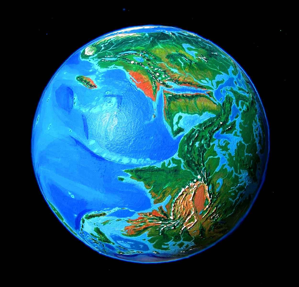
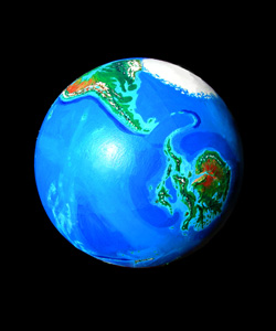
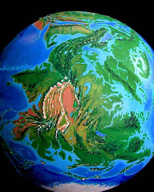
For clarity, I've removed the cloud cover. Earth has changed so much it'll be hard to recognize, even without clouds blocking the view (to right: Africa above, Asia below, Europe in shadow at right). North is always up, except for polar views. Oh--these orbital photos aren't digital modeling but shots of a real globe tilted and repainted to fit the new sea level and climate. So don't email me asking to borrow my dataset--it's my brain. I've learned from painful experience: never loan your brain.
When charting Seapole's coastline, I made a few exceptions to the 100-meter contour. I didn't enlarge Hudson Bay much--in our world, the area's still depressed from its ice burden ten thousand years ago. But Seapole is warmer, and is unlikely to have had any recent ice ages, so Hudson Bay might be small, or not exist at all. Yet with sea levels so much higher, some of the Canadian Shield would certainly flood. But how much? In the end I just marked a modest sea-incursion and gave up. I left the Great Lakes alone, too, though they're largely artifacts of the Ice Age. I don't know what that region looked like before the ice, and I'm not sure anyone does. For the same reasons, I've shown Greenland's inland sea somewhat smaller than the 100-meter sea rise would justify. But there might be no inland sea at all, but a near-Amazonian basin dotted with lakes.
On the other hand, for the Baltic Sea, I marked the sea-rise in full, just for shock value--it turns "continental" Europe into a maritime peninsula little wider than France, all the way to the Urals. Maybe I should reconnect Scandinavia to Europe and drain the Polish Gulf, but aside from creating a wider, more Amazonian rainforest there, and perhaps a drier Caspian/Caucasian region to the west, I don't think it'd matter much except to the locals.
The huge gulfs of Siberia, on the other hand, will certainly exist, and affect climate far inland--in our world these lands weren't heavily glaciated and aren't rebounding much, so in a tropical world, they'd likely be about the same altitude--that is, low enough to flood.
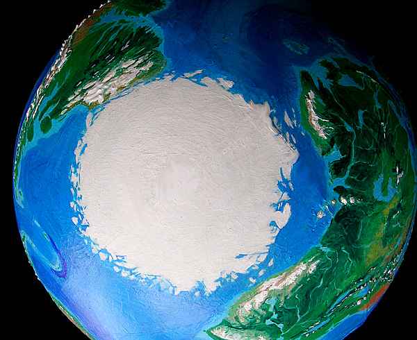
Antarctica is the least certain, of course. Our soundings have (crudely) mapped a complex land groaning under two or three miles of ice. Without that burden, Seapole's Antarctica would ride higher, and thus be larger--perhaps quite a bit larger. For simplicity, I declared that the first centuries of rebound (it's slow, taking thousands of years) would be roughly canceled by the higher sea level, so I could use what data we have without further guesswork... but that's probably wrong. The land might well be even larger, the islands more numerous--a huge, intricate, unpredictable continent, the most fascinating of them all. It just looks like a turkey.
A TOUR OF SEAPOLE
Climate - Map - Ornithia - Amazonia - Caribbean - Gringolia - Siberia - Europe - Africa - Arabia - Asia - Roo - Biology - Culture - Lessons
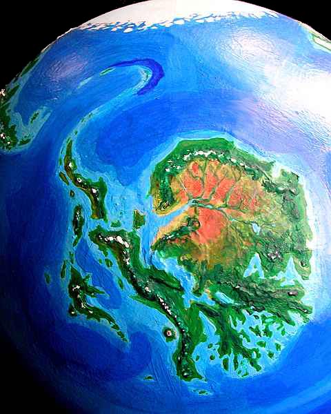
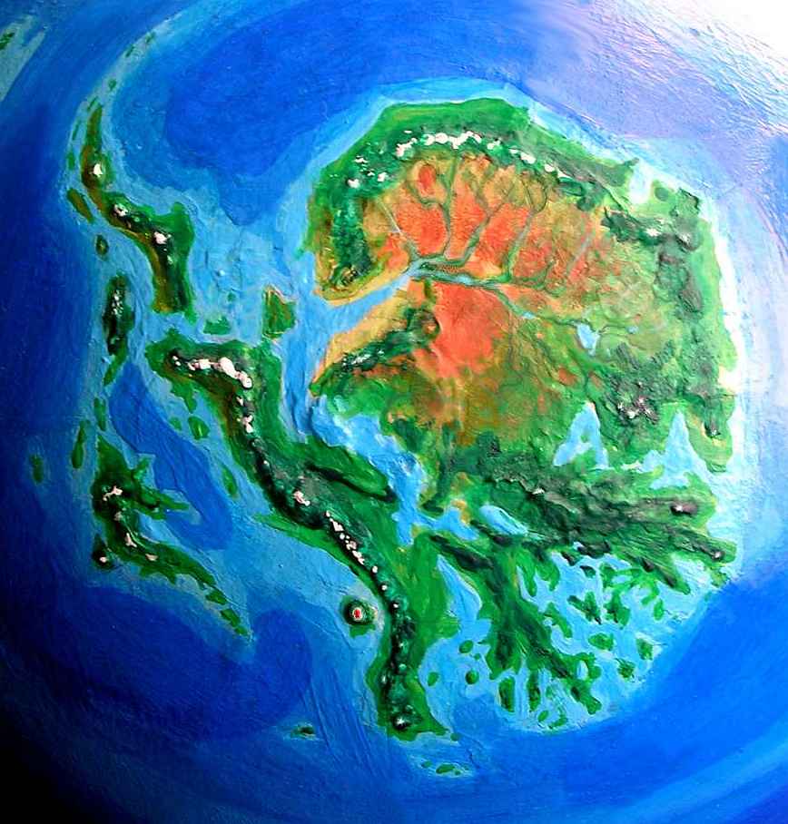
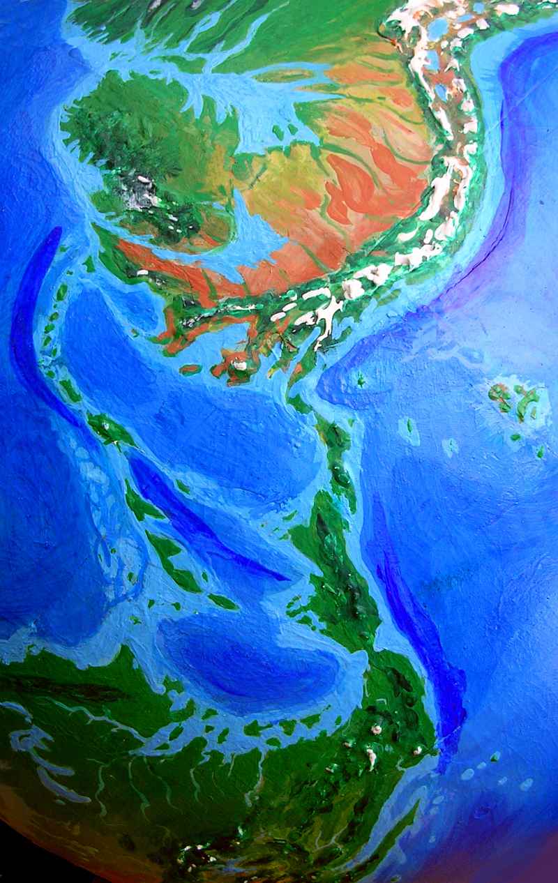
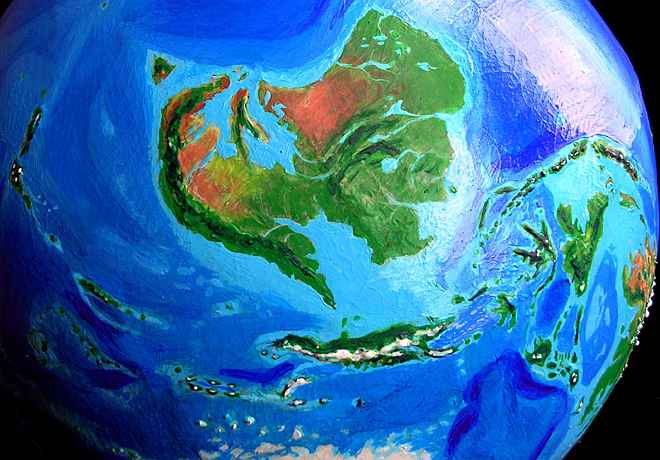
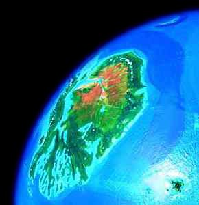
Our first stop presents us with a naming problem: a tropical continent north of the equator can't be called Antarctica! And, stripped of its ice, it's nearly unrecognizable. Let's call it Ornithia, based on its dominant life forms (see BIOLOGY). And on its birdlike shape--with its long western neck, spindly southern body, huge ragged wing/tail north and east... it's a thanksgiving turkey as drawn by a wobbly five-year-old. A turkey 4000 km long.
Ornithia is mountainous, warm, and broken up--its convoluted coast rivals Europe for complexity. The long dragon's spine on its west shore is the Trans-Ornithan Range, with steep jagged peaks rising 4-5000 meters from the sea. Near the south end, the small island with a crater is Mt Erebus, a gigantic live volcano looming over a tropical sea--a living Cretaceous cliche. The warm Ross Sea, and its great islands, are all that remain of West Antarctica. These long, snaky, mountainous, tropical islands resemble Sulawesi or New Caledonia. The northernmost isle, Palmeria, reaches well up into the temperate zone, and resembles New Zealand. In our world, polar researchers have dubbed the merely chilly Palmer Peninsula "the Banana Belt"; ironically, it's about the only place in Ornithia where bananas won't grow.
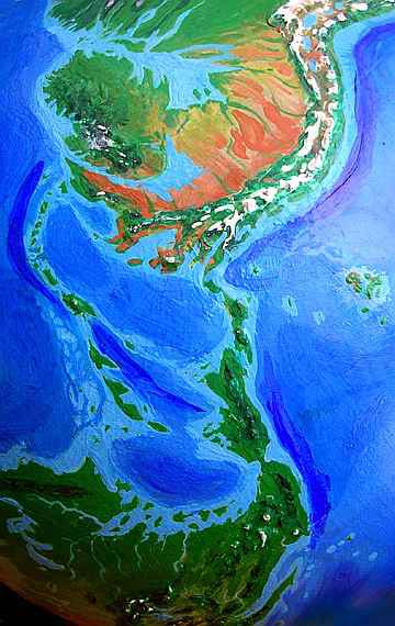
Ornithia's north shore is a fertile country like Natal in South Africa, rising from the sea to the alpine Princess Range. Behind the mountains, in their rainshadow, is the Maud Desert, broken by many snow-fed streams running down to the Valkyrie River, which cuts a Colorado-like canyon through the desert from Lake Valkyrie in the east (where the coastal range lowers and breaks up around Amery Bay, letting in enough rain to sustain savanna) to Pensacola Sound in the west, nearly as dry as our Baja Peninsula above the waterline, and just as riotously fertile below: fed by nutrients from the riverdelta, its warm reefs rival the Sea of Cortez as a diver's paradise.
Southeastern Ornithia is a complex maze of islands, waterways, and mountain chains. The dark area below Avery Bay is the Argus Range, a cool, forested tropical highland 2-3000 meters up. The lowlands here resemble Indonesia; in these sheltered gulfs, maritime cultures would flourish. If these gulfs exist at all; without its ice burden, the land might ride so much higher than current soundings that these bays and islands might be mere hills and lakes peppering a Congo-size jungle.
South America is now north of North America, and reversing their names would be confusing, so let's call this continent Amazonia, and the other one Gringolia. Whether there are gringos there is a question we'll have to defer til the Biology and Culture sections below. Anyway...
Climate - Map - Ornithia - Amazonia - Caribbean - Gringolia - Siberia - Europe - Africa - Arabia - Asia - Roo - Biology - Culture - Lessons
Patagonia, the long eastern cape of Amazonia, resembles Japan, with lakes, inlets, and snowcapped volcanoes, and a temperate climate with pronounced seasons.
The southern shore of Amazonia, between the Andes and the sea, is a land apart--a Mediterranean strip 5000 miles long, watered by small streams coming down from the mountains. Small city-states could flourish here, trading in a long arc from Panama to Tierra del Fuego.
In the northeast, the Plata Gulf is a cool-temperate region like the Gulf of St. Lawrence. From here, the Great North Woods stretch all the way across the continent to the Amazon Gulf. In the far north, the Bahia Mountains rise to 2500 meters and support extensive glaciers, the largest in the world, rivaling our Baffin or Ellesmere Island. (Or more. Glaciation is so poorly understood! The Highlands might just be able to sustain a Greenland-sized icecap, completely changing the Amazonian climate from forest and desert to tundra, with forests only in the south, making Amazonia positively Canadian. But let's stick with the warmer scenario to maximize flooding, and see what happens.)
 The western Bahia uplands are lower and warmed by the Moroccan Current, so the climate is milder, rather Alaskan, with spruce/fir forest, and tundra right up to the polar ice pack and east along the northern shore, supporting great herds of caribou--or arctic emus or ostriches or kangaroos, if placental mammals never made it here (with the high sea levels and lack of Ice Ages, the land bridge to Gringolia probably never existed. Still, the Managua Strait is narrow. So let's allow caribou and polar bears. Why not?)
To the south of the Bahia glaciers, cool-temperate rainforests with huge cedars and redwoods stretch deep inland, only gradually thinning, for unlike British Columbia or northern California, the ranges here are aligned east-west and let storms hundreds of miles inland.
Further south, the Amazon Gulf lands are temperate, fertile, and European in climate, though growing more continental and drier inland, becoming grassy steppes around Bolivia and Paraguay, and true desert to the south, though broken up by many riverine strips fed by the Andes. This Orinoco Desert might well become a cradle of civilization resembling Egypt or Mesopotamia, but larger, and with far more rivers.
On the southwest coast, Guyana is quite Californian, with a dry sunny Mediterranean climate on the coast, and pine-forested uplands full of Yosemite-like waterfalls and canyons. The Gulf of Venezuela is an intricate tangle of desert, grasslands, scrub, forests, and alpine meadows. Alpine meadows? Yes. Don't miss the Sierra Nevada de Santa Marta, a spectacular range rising 5700 meters/19,000' directly from the sea! Here too, snowfed streams in the dry lowlands might lead to irrigated agriculture.
Climate - Map - Ornithia - Amazonia - Caribbean - Gringolia - Siberia - Europe - Africa - Arabia - Asia - Roo - Biology - Culture - Lessons
The Caribbean climate remains warm. It's a bit drier, especially in the north, along the Colombian and Venezuelan coast. But most of the region is recognizable.
Most of the Caribbean islands are mountainous, and thus survive; but Cuba breaks up into an island chain, and Florida and the Bahamas are now just huge coral reefs with a few islets.
The biggest change is geographic, caused by the high sea level: the Managua and Panama Straits, two narrow channels severing the land-bridge between the continents. Such shallow, narrow straits (only a mile or two in places) might not totally block animal migration between Amazonia and Gringolia, but they'd certainly inhibit it--currents in these channels might be very strong.
The effect on sea life would be large--twin warmwater gateways between the Atlantic and Pacific. Expect more spillage from the Pacific into the Atlantic, since prevailing winds and currents would flow in this direction.
Climate - Map - Ornithia - Amazonia - Caribbean - Gringolia - Siberia - Europe - Africa - Arabia - Asia - Roo - Biology - Culture - Lessons
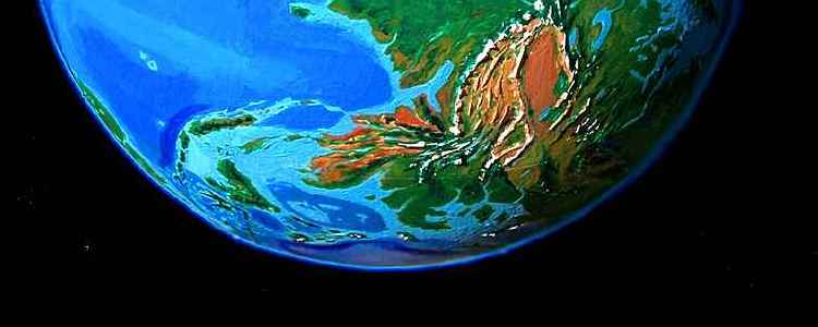
The Isthmus of Tehuantepec is very narrow, nearly cutting off the Yucatan and Central America from the rest of Mexico. The mild climate of the central Mexican highland now extends all the way to the US border and beyond, creating a complex but generally fertile strip stretching all the way to Alaska. Rainshadows still create savannas and grasslands between the forested ranges, but the climate resembles the more fertile parts of east Africa, like Uganda. Making the analogy closer, great lakes fill the valleys and basins of Utah and Nevada (lower right). The Gulf of California extends nearly up to Palm Springs and Needles, while the Central Valley is an inland sea again. The two gulfs nearly make the coastal strip an island 2000 km long. To the west, the lower Willamette/Columbia valley in Oregon has fused with Puget Sound in Washington to form a third inland sea. From Baja to the Alaskan Panhandle, the coast is wet subtropical, like southern China.
Inland, over the mountains from this lush wet coast is a long, drier strip of rather Kenyan highlands. This environment, judging by our own world, is a potential cradle of humanoid evolution, assuming suitable primate candidates are present. They'd have to have evolved in isolation since the breakup of Pangaea, or crossed the now-temperate Bering Strait. It's unlikely--gorillas and chimps find it hard to cross even large rivers. Still, the south coast would be a friendly corridor leading them from Alaska--and inland, the savannas would beckon...
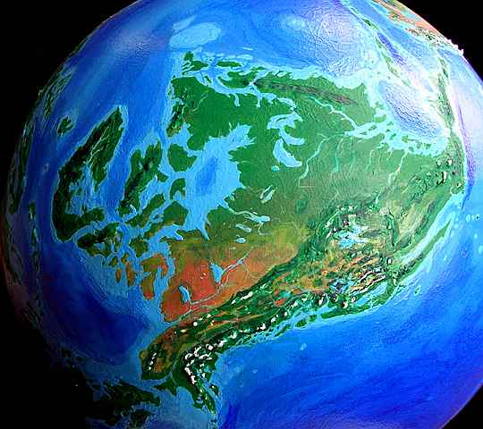
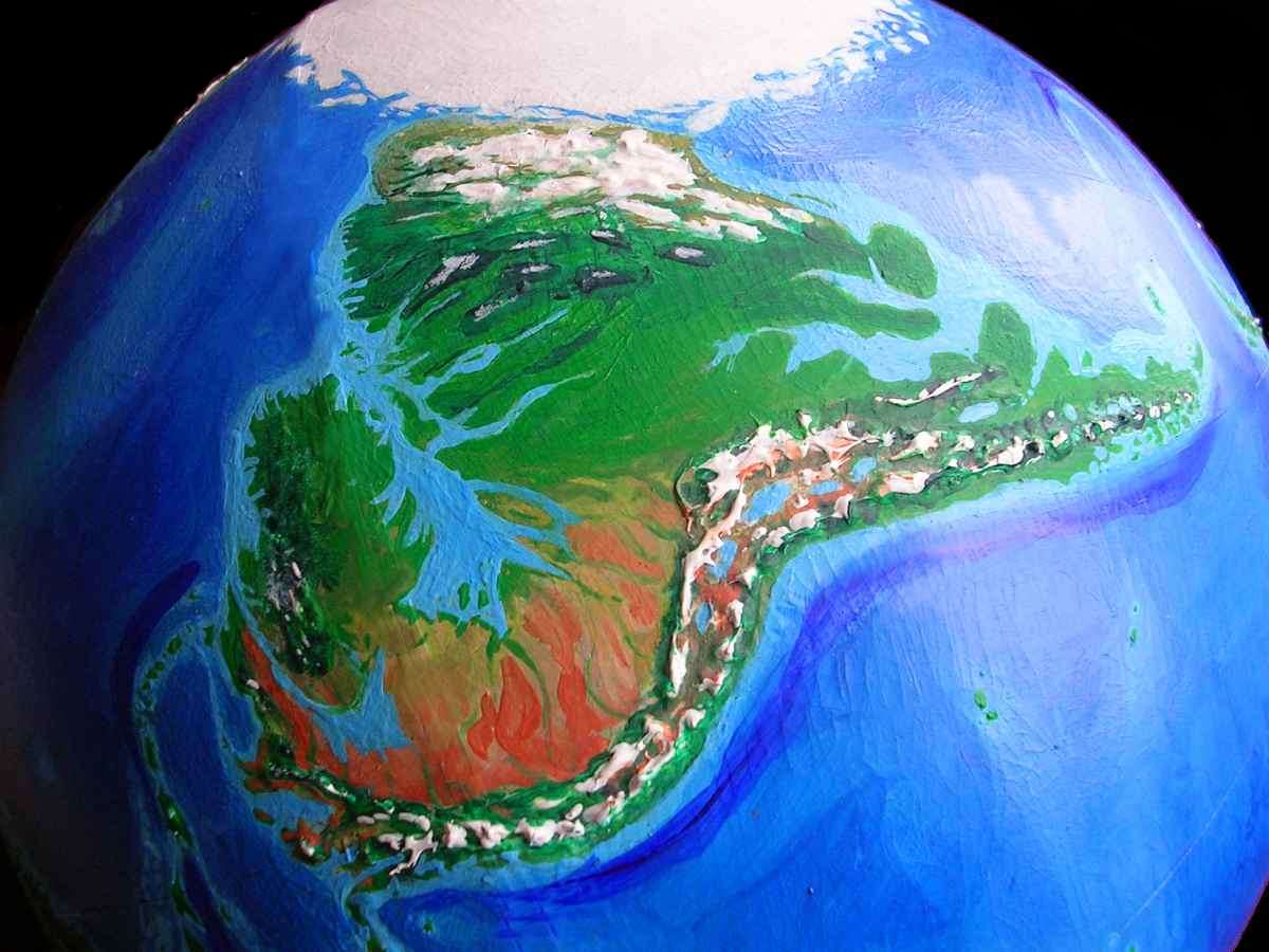
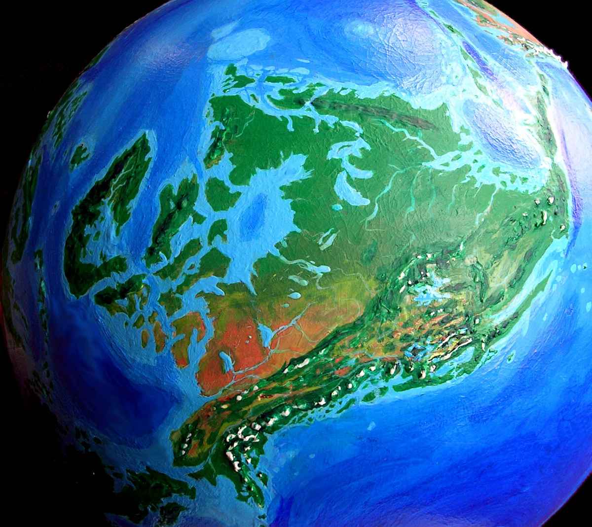
Wait, are you oriented here? Mexico on your right, Greenland left, New England top, Alaska bottom? As I mentioned before, if I were totally consistent this continent would be even less recognizable--I'd replace much of Hudson Bay (center) with jungle. During our last Ice Age, the weight of the North American ice sheet pushed Hudson Bay's bedrock below sea level; but without that icy history, the bay might be much smaller, even with Seapole's higher seas. The Great Lakes are equally doubtful. Oh well, there they are. I had to keep 'em.
Why? Gringo readers don't know geography. Gotta spell it out for them! I've been more rigorous about changes and left fewer clues on the other continents--most of my Latin American, Pacifican and Old World readers are geographically literate enough to recognize their home continent at least, even tilted and covered with strange make-up. But when I pull this globe out at parties and ask Americans (yes, this says something about me, too, but let's not get into my unbelievable nerdiness), well... they don't even recognize it as Earth, let alone find North America. So have you found home yet? (Floridians, you're excused--your home's not lost in the glare. Home's never been! Florida's just a maze of coral reefs.)
North of the Rockies, the High Plains are forested; indeed the Mississippi basin, Appalachia, and most of Canada are one unbroken rainforest rivaling our Amazon. The northern shores are shallow; great coral reefs flourish all the way out to the Grand Banks. Native cultures will be maritime! This maze of tropical islands, reefs, and indented coasts stretches from lost Florida to the isles of New England and Baffin Bay, and beyond--Greenland has an inland sea full of coral reefs, Iceland and Spitsbergen resemble Sri Lanka or Hawaii... in fact, the pattern stretches all the way into what we call northern Europe--Scotland, the British and Irish Isles, Scandia, and the lesser islands of Gdansk, Estonia etc, in the Baltic Passage to Siberia. Climatologically and culturally, everything from Poland to Panama might well be considered one vast region.
Southeastern Gringolia, however, stands apart. Alberta and the Mackenzie plains are drier, ranging from grassland and savanna to true desert in the rain shadow of the western Rockies. The snow-fed Yukon and Mackenzie rivers would be reliable water sources and, like the Orinoco, might nourish Egypt-like civilizations along their warm, sleepy lower stretches. Alaska as a whole resembles Greece, though doubled in every dimension (including vertically). The gods would, of course, live atop Denali. I have no doubt this would be a major cradle of civilizations--fertile, ecologically diverse, and a crossroads for both land and sea trade.
Climate - Map - Ornithia - Amazonia - Caribbean - Gringolia - Siberia - Europe - Africa - Arabia - Asia - Roo - Biology - Culture - Lessons
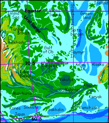
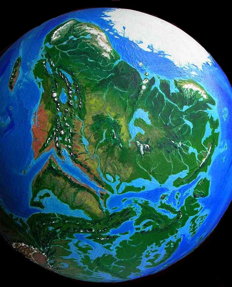
Siberia is lush. The warm Greenland Ocean, swollen much larger than our Arctic Sea, generates rain feeding jungles from the Sea of Ob all the way south to the more temperate Anadyr Peninsula.
The closest climatic analogy in our world is East Asia, from Manchuria down to Vietnam; and I suspect coastal Siberia would be a similar cradle of civilization, sustaining high populations with its reliable rains.
But Seapole's Siberia will be less unified, for the geography is broken up, more like our Europe:
- The steaming, boggy shores of the Gulf of Ob, with its endless islets and waterways, like a hundred Louisianas
- To the south, milder and hillier: Tungusia, Taymyr Islands, the sinuous Lena Gulf and rich bottomlands of the Lena River (the Siberian Mississippi); Yakutia's hills, and the gentle Anjou Isles
- the warm-temperate hills of Kolyma and Anadyr, like our South China? Appalachia? Peaks will see snow.
- Along the Pacific coast, temperate lands like Koryak and Manchuria: France? Snowy winters, but not severe by Earth standards.
- Offshore: the cool green (English? Japanese?) islands of Kamchatka, Sakhalin, and Sikhote; further out, the island arc of Japan, all somber Nordic forests below icy volcanoes
Each of these capes and islands would likely nourish distinct cultures, as peninsular Europe did; the geographic deck seems heavily stacked against a Chinese unity and continuity.
Climate - Map - Ornithia - Amazonia - Caribbean - Gringolia - Siberia - Europe - Africa - Arabia - Asia - Roo - Biology - Culture - Lessons
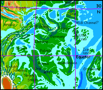
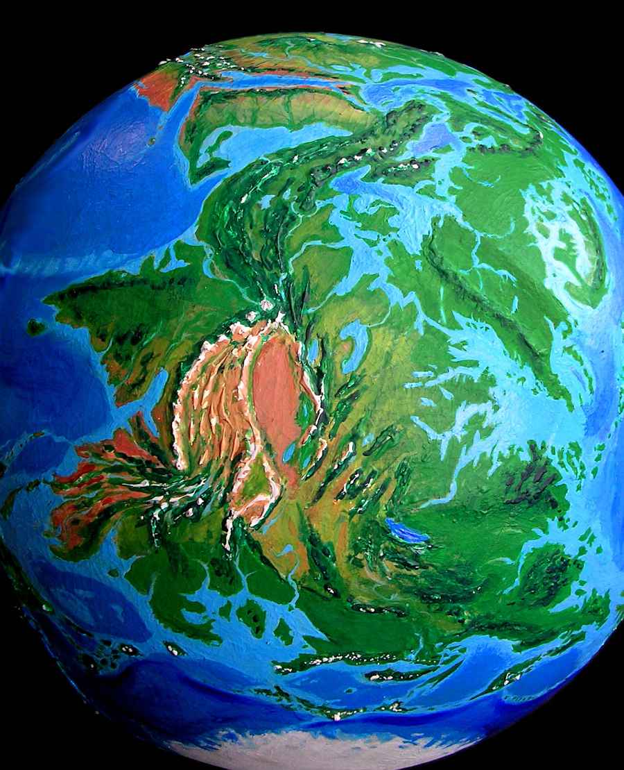
From Siberia let's head north toward the equator (ha! I like the sound of that) toward EUROPE. Yes, it deserves all capitals now--Europe may be a real continent at last, not just a big cape with imperial pretensions. It's largely cut off from Asia by the Ob Gulf and the Inland Sea (the fused Black/Caspian/Aral Sea). The real question is whether the narrow, shallow Turgay Channel would really run all the way through to the Inland Sea or not--it's close to the sea level I've projected, so a few meters either way would cut off Europe totally or leave a land-bridge to Siberia.
The consequences for land-animal migration are obvious. At first glance you'd guess a Turgay Strait would affect sea life even more: not only could you swim from the Greenland Sea into the old Mediterranean basin, but you could continue west through the Suez Strait to the Indian Ocean; and the Suez is the only warm-water passage between east and west hemispheres. But even if Turgay is an isthmus not a strait, warm-water life can still spread through Gibraltar to Suez; not quite as tropical, but pretty mild.
Let's assume the Turgay Strait is there, and follow the current (left and upwards). The wide pale sheet of water past the strait is the old Aral Sea; beyond is a strange, contorted island called Usturt or Ustyurt. A mere patch of desert in our world, its fertile plains form an isle as big as Britain. Or what's left of Britain.
Further up is the deeper, bluer Caspian, with the fertile triangle of Yergeni Island and mountainous Cape Caucasus; the Black Sea lies beyond, and then the enlarged Mediterranean at the top, upside down but recognizable: its shores are largely mountainous, so the sea couldn't sprawl here as much as it can over our Central Asian steppes.
A second, less crucial uncertainty is the narrow Midi Strait between Iberia and France. Our Midi Canal in southern France is right about at my projected sea level; if this valley floods on Seapole, currents will certainly scour it deeper. As with the Turgay Channel, the question isn't vital for Seapole's climate, since the Straits of Gibraltar and the Suez Strait to the north let water circulate, and they cut off access to Europe for land animals.
This new, genuine continent of Europe is a hot rainforest nearly as large as the Mississippi Jungle. There are ecological islands: the Alps have a mild, Ethiopian climate: spring all year. Mont Blanc, Monte Rosa and the Matterhorn even have snow patches, but few others do. The west coast of Italy, in the rain-shadow of the Alps and Apennines, has savanna and open woods, except for the plain of Lombardy--it's a coral sea, extending the Adriatic right to the feet of the Alps. The Iberian plateau, further north and higher up, is cooler but but still wooded, except behind the Pyrenees and Sierra Nevada, where strips of grassland open up. But most of Europe's wall-to-wall trees--a rich world above, and gloom underneath. A broken Amazonia, or a more continental Indonesia?
Other changes? Scandinavia will no longer be able to host the Winter Olympics. No winter! Scandinavia's now a huge equatorial island cut off from Europe by the swollen waters of the Baltic. You probably didn't recognize it, and not just because it's tropical and upside down. The fjords are gone. No Ice Age, no glaciers. No glaciers, no fjords.
Same goes for the hilly but not savage coast of Greenland and the Canadian islands--that wasn't me being lazy! I was exploring consequences. Ice shaped our world, and we don't even notice, we're so used to sculpted peaks, continental shelves of a certain depth... and fjords. Seapole's geography made it warm; but its warmth also affects its geography.
Climate - Map - Ornithia - Amazonia - Caribbean - Gringolia - Siberia - Europe - Africa - Arabia - Asia - Roo - Biology - Culture - Lessons
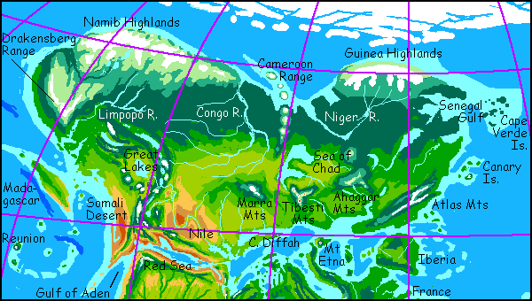
Africa's greener too. Morocco (right) resembles the East Coast of the U.S., with hot muggy summers and cool winters, even rare snows, though it's sheltered from Arctic storms by the Atlas Range, much higher than the Appalachians. Inland, the rain shadow of the Atlas Range creates savanna not desert, for the Tunisian Gulf to the southeast, Lake Mauritania to the north, and the Sea of Chad to the northwest all mitigate the Sahara's continental climate. In summer it's hot and rather muggy near the coasts with dry heat inland, and snowy in winter, as nothing shields it from the Arctic but the glaciated Guinea Highlands.
Green on the coast, the land turns to prairie inland--the largest grasslands on Seapole. In the north, from the Gulf of Gambia to Capetown (some 7000 kilometers) sweeps a great boreal forest, warmer and thicker than our Canada or Siberia: the treeline reaches the north coast in most places, fading into tundra only near the great ice fields of Guinea and Namib. South of the glaciers, great lakes like Etosha and Okavango feed the cold, milky Zambezi and Niger rivers.
In the far west, coastal South Africa has a surprisingly mild climate for its latitude, due to the warm Kerguelen Current, similar to our Gulf Stream. Inland, the Drakensberg Mts form the third great icefield of Africa. Behind the Drakensbergs, a high plateau stretches hundreds of kilometers. Too harsh for forest, it's the world's most extensive tundra, broken only by the low Orange River Valley, dark with arctic spruce.
To the south, Mozambique, Malawi and coastal Tanzania resemble Oregon and California. Madagascar has shrunk but is still as big as California; and with a similar climate--the southwest coast is nearly as dry as Baja, and the east coast is savanna and desert. Still, the highlands support open pine forests. Lemur habitat is limited; they'd do better on the rainy mainland.
The African Great Lakes deserve special mention. This region, inland and high above the sunny west coast, resembles Mexico or the American West--a complex patchwork of mountain forests, high grassy plains, small rainshadow deserts and savannas, with a climate tempered by the many large lakes fed by snowmelt from the volcanoes. The plateau is high in the South and low in the north, evening the climate, which is wetter than in our world. Ecologically complex, the area's a potential cradle for intelligent species, human or not. Once inhabited, it's also a likely nursery for the development of agriculture and irrigation.
Poor old Somalia has hardly changed a bit--still arid near the Kenyan border and true desert further south. The small isle of Socotra, on the edge of the tropics, gets some monsoon rain in the mountains, so small streams water its dry sunny coast.
Egypt and the Sudan, while warm and rather dry, are Sahelian grasslands, and are now watered by two great rivers--the enlarged Nile, fed by not just by the Blue and White Niles but a third great tributary draining the wooded Marra Highlands, and the shorter Uweinat, an eastern river coming directly from the highlands to a series of lakes dotting central Egypt. North of the Marra, from the Congo River to the Sea of Chad and beyond, is an immense prairie, golden in this summer shot. Three snowy ranges, the Marra, the Tibesti due south of the Sea of Chad, and the lower but broad Ahaggar Massif in the east, support extensive evergreen forests and are the source of rivers watering both the northern woods and steppes, and the green Mediterranean plains of the South.
The mouth of the Nile is a long gulf, not a delta. The hilly Diffah Peninsula wiggles east all the way to Libya; coral fills the Qattara Gulf between Diffah and the shore. The long coast east to Morocco again is Mediterranean--olive and oak and citrus groves, brushy hills and small meadows.
Climate - Map - Ornithia - Amazonia - Caribbean - Gringolia - Siberia - Europe - Africa - Arabia - Asia - Roo - Biology - Culture - Lessons
The RED SEA is superficially unchanged--ringed by mountains and at nearly the same latitude north, it's still a desert sea, trapped in a rainshadow. But it's grown: the Afar Depression is now a gulf, and the Sinai Peninsula and Palestine are now an island, or nearly; and the Suez is a strait pouring into the Mediterranean. The steady flow from the Indian Ocean through to the Atlantic makes the eastern Red Sea and western Mediterranean nearly as fertile as the southern Red Sea is in our world. Coral reefs flourish all through the INLAND SEA (the Aral-Caspian-Black-Mediterranean-Red Sea complex, far bigger than our Mediterranean), instead of being confined to the Red Sea.
In ARABIA, the monsoon dominates. The shores of the enlarged Persian Gulf are greener than in our world. The mountains of Oman (little-known outside the country, but nearly two miles high) trap enough rain for extensive forests; Oman is now nearly an island nation (tip of peninsula, lower left). Arabia proper shades imperceptibly from monsoon forest on the Gulf coast to savanna to grassland and desert in the north, like our Sahel. But unlike the Sahel, rivers vein the plain, nourishing great herds of grass-eaters (and their predators). These are snowmelt streams, flowing from the mountains above the Red Sea, which support pine forests on their slopes. Yemen (top left of peninsula; snowy) remains a green ecological island with desert at its feet... just not in all directions.
Climate - Map - Ornithia - Amazonia - Caribbean - Gringolia - Siberia - Europe - Africa - Arabia - Asia - Roo - Biology - Culture - Lessons
In ASIA, Turkey, Persia and Afghanistan also form one unified highland, but a tropical one, with the Caucasian Peninsula as an isolated outlier. Mountainous, well-watered but with local rainshadows, mild in climate, in places fertilized by volcanic ash, it resembles a gigantic Uganda or central Mexico. The dry basins in our central Iran are now large lakes. This upland, like the West Africa it resembles, might evolve intelligent hominids.
INDIA is more tropical and wetter overall, but the wet and dry zones are reversed: Peninsular India and the Deccan are wet year-round, while Pakistan is monsoon forest, like our plains of the Ganges. Conversely, the Ganges is drier, on the edge of the tropical zone. What there is of the Ganges! The Ganges Gulf reaches all the way up to Benares, and its southern arm stretches deep into Assam, forming an inland sea like California's, ringed by even higher mountains. Bangladesh never existed, and Burma, to the south, is just an arc of desert hills rising from a coral sea, like our Sea of Cortez.
TIBET is closer to the equator, especially its higher end near the Pamir Knot. It's still cool and dry, but can sustain grasslands resembling the Altiplano, and the deeper valleys are forested, even atop the plateau.
The Central Asian steppes still exist, but range from savanna to grassland, rather than from grassland to desert. The one true desert, the Taklamakan, is ringed by some of the highest mountains on earth, blocking storms no matter what its orientation or latitude. Like the Red Sea, its topography is its destiny. Even so, at its south end, Lop Nor and the Turfan Depression are now good-sized lakes below the Tien Shan, a range much greener and more heavily forested than in our world.
Though the climate's milder, MONGOLIA rivals Somalia as the least changed region of this alternate Earth. Mountains with conifer forests alternate with wide grassy valleys and plains. Biggest difference: the Gobi is no desert, but a vast sea of grass.
ANADYR (Asia's southeastern tip) is Japanlike, with a temperate climate but stronger seasons and colder winters than Grecian Alaska across the strait. Korea, Kamchatka and Sakhalin all resemble Hokkaido, which is remarkably unchanged: boreal forest and snowy volcanoes. But the rest of JAPAN is near-Arctic--the north coast supports sparse spruce taiga, but its south coast, unshielded from the pack ice only a few hundred miles south, is tundra. Fuji is ice-clad nearly to its feet, except when it erupts.
CHINA: The mountains of these cool island arcs shield the mainland somewhat from Antarctic storms, making Okhotsk and Manchuria temperate if snowy in winter. The Shandong Islands and the many capes and bays around the new, shallow Gulf of China are like Oregon--rainy and mostly snow-free. The Tonkin Gulf, the island of Hainan, and much of Indochina have a Mediterranean climate, with warm dry inland valleys, mountain forests, and oak-grassland coasts with mild year-round weather. These dry sunny valleys, with great rivers fed by snowmelt from the Tibetan plateau, are another region where irrigated agriculture might develop.
BORNEO ISLES: To the west lies one of the world's great temperate zones--the Borneo Archipelago. This vast complex of islands and peninsulas ranges from the Norwegian forests and icy peaks of Papua through the cool rainy English climate of Taiwan, the Philippines, Sulawesi and Halmahera, to the warm-temperate French Borneo, to the quite Californian Java, Malaya, and Sumatra, with their sunny coasts and forested volcanoes. While not large in land area, perhaps 800,000 square miles (2M sq km), it's varied and fertile enough (even without its rich seas) to support multiple civilizations, and forming a bridge to the smallest continent, Roo.
Climate - Map - Ornithia - Amazonia - Caribbean - Gringolia - Siberia - Europe - Africa - Arabia - Asia - Roo - Biology - Culture - Lessons
Roo is not Australia. Two numbers tell the story: 25% smaller, but double the biomass. The entire east coast, from subtropical Perth through the Kimberlies to temperate Darwin, is green and rainy. With no mountains to block the rains, forests and fields stretch 1000 kilometers inland, all the way to Alice and the central ranges. The Nullarbor Plain is not treeless, though they're sparse. This photo, in summer, shows it red and dry, but the winter grass feeds mobs of... what? That'll have to wait for our next section: biology.
The heart of the Australian desert is gone, for from Adelaide through Lake Eyre nearly to Uluru itself stretches a warm, sheltered inland sea, with some of the southernmost coral reefs in the world. West of Cape Flinders (a thousand-kilometer peninsula resembling Greece) a second gulf floods the Murray and Darling Basins.
In the south, too, the Gulf of Carpenteria thrusts deep inland, leaving a green isthmus only a few hundred kilometers wide between East and West Roo.
At Roo's southern tip, the York Peninsula has dense temperate rainforests with hundred-meter gums... or sequoias. Roo's west coast resembles Oregon, becoming Californian in the warmer north. In the rainshadow of the coastal mountains, patches of dry Outback survive, but the Darling Gulf moderates the climate--even the Artesian Basin has many year-round streams and a mild Mediterranean climate.
ZEALAND, to the west, is warmer and drier, a patchwork of microclimates--rain forests, grasslands, and small rainshadow deserts. The mountains rise high enough for snow, so river strips remain green even in summer. With its isolation and diverse climate, it rivals Madagascar, Kerguelen (see next section) and Ornithia as a land rich in unique species.
By the way, it's not called NEW Zealand because there was no "old" Zealand; at Seapolian sealevels, the Low Countries never existed. (Well, there are some lovely coral reefs...)
THE PACIFIC ISLANDS still survive, despite the higher sea. They're about the same size, for the islands in the temperate zones are mostly volcanic peaks that erode back toward whatever sealevel is, and most tropical isles are coral atolls that tend to build UP to sealevel--again, no matter what level that is.
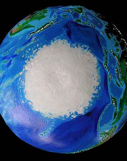
The northern Melanesian islands and the Marianas reach into the Antarctic ice pack, anchoring it so that it cannot rotate freely with wind and current. They're like a great scraper peeling off the outer layer on a rotating wheel. Irregular tongues of fractured ice are forced north, up to latitude 60, in places.
Quite by accident, Tahiti and much of POLYNESIA remain subtropical. Wet and dry sides of taller islands have reversed, but that's about the only change.
Subarctic HAWAII resembles coastal Washington (or perhaps a milder Iceland): glaciated volcanoes rise from temperate rainforests. The northern skirts of the big shield volcanoes, tilting toward the sun, are quite mild. Land life will likely be dominated by huge flightless birds.
Climate - Map - Ornithia - Amazonia - Caribbean - Gringolia - Siberia - Europe - Africa - Arabia - Asia - Roo - Biology - Culture - Lessons
The evolutionary biology of Seapole is obviously uncertain, but a few points are clear. The New World is less isolated: primitive rafts or just a knack for swimming (bears, elephants) would suffice to cross the warm straits. But hoofed animals aren't great swimmers. In our world, they've had intermittent Bering and Panama land bridges to cross, and ice in winter; but in Seapole, without ice, Amazonia and Gringolia would be hard for hoofed grazers to reach, and grasslands are limited until you reach the steppes of Amazonia. Amazonia at least will have evolved largely in isolation. Before Pangaea broke up and the Atlantic Ocean formed, Pangaea was centered on the North Pole, and was heavily glaciated. The lobes of ice-free tundra below the cap would have been biologically rather separate, even then. So Amazonia may have been going its own way since the age of the early mammals, with species nearly as peculiar, by Old World standards, as Australia's.
Roo is more isolated than our Australia--the straits are hundreds of km wider. It would remain a hotbed of marsupial evolution. Intelligent land animals, human or not, even basically amphibious ones like elephants, couldn't reach Roo without decent boats. But Ornithia/Antarctica is even more isolated, larger, and more varied in climate (having much more altitude variation). The large islands of west Ornithia are each as isolated as Madagascar or New Zealand; each might develop wildly different flora and fauna. Further, like those islands and unlike Roo, migrating peoples would need more than mere rafts to find and settle Ornithia. The continent would be settled late--if at all. The wave of extinctions as Stone Age hunters spread around the world might never have reached Ornithia, or at least have failed to finish the job yet--even the first Americans took a while to kill off the Ice Age megafauna. Giant crocodiles and Komodo dragons 25 feet long, or half-ton flightless birds, or packs of giant roo-eating marsupial wolf- or bear-analogs (or all of the above) might still dominate Ornithia. Or intelligent primates based on lemurs or tarsiers, not apes, might have evolved. And with their weight-limit removed, large omnivorous birds might evolve complex social cooperation, large brains, tool use--and language.
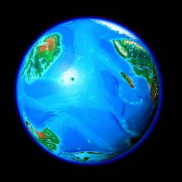
But the lands most likely to have been entirely untouched by predatory sailors or settlers are not Ornithia, which is, after all, too big to miss once boats are invented, or Zealand, which the cultures of Roo would quickly discover, but Hawaii (here a cool-temperate volcanic chain trailing off into the Arctic icepack) and the much larger but little-known Kerguelen Islands, 2000 kilometers off the coast of Ornithia and 3000 from Madagascar. On Earth, Kerguelen is cold and wind-blasted. Not on Seapole! In this orbital photo, it's that dark (dense-forested) spidery blot in the sun-glare in the bottom-right corner. Four times bigger than Hawaii but the loneliest fertile land on Seapole, Kerguelen would evolve bizarre species. If it has large land mammals they'll be descended from sea lions or sea otters. These might develop into fructivorous tree-climbing quasi-primates, wolflike pack animals with brains larger than chimps (seals and otters are smart, big-brained animals), and even elephant-analogs. Again, social sophistication and big brains might lead to tool use and language. If such island oddities sound unlikely, consider the tool-using sea otters of California's kelp forests, or the sea-grass-eating marine iguanas on the Galapagos--and Kerguelen is far larger, more fertile, and more isolated.
There's a common impression that island continents fall behind, becoming "fossil" ecosystems, whose species may be fascinating and quaint, but can't really compete on a world stage. One doesn't expect intelligence to evolve among kangaroos. But it's a question of odds, not an immutable law. Corvids (ravens, crows, jays etc), rivaling their cousins the parrots as the most intelligent birds on our planet (indeed, if recent studies are correct, rivaling primates) spread from Australia, only recently as geological time goes--and conquered the world.
So, on Seapole, with more and larger (and more widely scattered) tropical forests and savannas resembling ancient Africa, multiple species of language- and tool-users could evolve without coming into direct competition. Several branches of the primate family (lemurs, apes etc), elephants, bears or raccoons, large otters, and huge flightless corvids and parrots are all possibilities--all big-brained land species capable of (or already engaging in) tool use and thus potentially capable of mastering fire.
Climate - Map - Ornithia - Amazonia - Caribbean - Gringolia - Siberia - Europe - Africa - Arabia - Asia - Roo - Biology - Culture - Lessons
Despite the smaller land mass of Seapole, so little land is frozen or dry that the fertile area is greater than Earth's! And different.
- Seapole's a tropic-centered world. But there are tropics and tropics. Our two greatest tropical forests are unbroken continental interiors, sparsely settled. Only our Southeast Asian jungle, and on a smaller scale the Caribbean, are broken into many islands and peninsulas, allowing easy trade and settlement; as a result these "broken jungles" have fostered denser populations and higher civilizations (the Malays, the Mayas and Tainos). But the jungles of Seapole are vast, and more like Indonesia than the Amazon or Congo. Even the great Euro-Greenland-Gringo-Caribbean rainforest is a maze of lakes, gulfs, bays, and islands.
- Seapole's a world of islands. On Earth, the Polynesians spread from Madagascar to Easter Island, but on Seapole, with its Inland Sea far larger than our Mediterranean, the straits of Suez and Nicaragua, and an ice-free Siberian sea and Bering Strait, Stone Age sailors could quickly island-hop all the way round the world. The tilted Pacific has vast temperate stepping-stones: from Asia to Roo to Ornithia to Amazonia to Gringolia and back round to Siberia, Europe, and Asia. There is no gap comparable to the one between our Americas and Asia/Australia, no barriers like our Suez or Panama; this is a world whose geography fosters sea-trade, not land-routes.
- Seapole is decentralized. Dry regions with reliable rivers seem to be nurseries of agriculture. We tend to forget that the tight clustering of our ancient world's great irrigable flood plains in the Near East is a geographical accident. Where conditions are right, whether in the Indus Valley, the Colorado Basin, the Yucatan, the Valley of Mexico, or the small streams from the Andes through the coastal desert, agriculture independently developed. In Seapole, such rivers abound on every continent: the many-branched Valkyrie River in northern Ornithia, the Orinoco in Amazonia, the Mackenzie and Yukon in Gringolia, the Great Lakes and the Kenya coast in Africa, as well as the Nile and its many sister rivers all across the former Sahara, the Brahmaputra/Ganges, the five great river canyons of Indochina, and the many streams feeding Australia's Darling Gulf... and on and on. There is no single, obvious center where agriculture, irrigation, and city-states would inevitably evolve first.
 Given the prevalence of rainforested islands, the center of gravity of Seapolian civilization, at least early on, might not be centralized "hydraulic" farm societies as on Earth, but wide networks of trading and fishing villages--that is, no real center at all. A worldwide sea-trade from the earliest days might flatten the sharp technological and military gradients that allowed empires and colonialism to become so extreme in our world. Seapole, with its web of island cultures, would not easily allow a single continent to dominate long.
I'm not postulating paradise. I suspect our problems of racism and colonialism would be replaced by problems of specism and tropical disease. Plague might replace war and famine as the great population-limiter. On the other hand, locally evolved peoples of very different species might not be able to handle the diseases and parasites of other continents (like the European colonialists in the tropics, but far more extreme), effectively limiting each species to certain regions or climates.
Some things, being driven by geography, not climate or culture, would remain constant. The Inland Sea is still the only easy sea-passage between the Indian Ocean, Europe, Central Asia, and the Atlantic--indeed, easier, as the Suez is a natural strait. Great port-cities would inevitably develop--Cairo and Istanbul and Gibraltar. But these would be rivaled by Qaanaaq and Etah, on the Kennedy Strait between bustling Siberia and sleepy Gringolia, and Beringia with its fifty-mile bridge from Alaska to Anadyr, and Managua on the strait between the Carib and the Pacific. Beside these great port cities, keys to the world's maritime trade, river-mouth cities also seem inevitable, though their sites would often be inland of ours: Para, serving the prosperous farmlands of the Amazon and the inland prairies; steamy St. Louis, exporting tropical products from the sweltering Mississippi Basin; fabulous Buffalo, with its locks up to the three Great Lakes (Superior, Huron-Michigan, and Erie), and its famous falls pouring into the sea (well, almost); Adelaide, where the Darling and Eyre Gulfs meet; and Pensacola at the mouth of Ornithia's great Valkyrie River...
Beyond this it's difficult to speculate. Would there even be a Managua Strait, or a narrow land-bridge? A few meters of sea level would decide it. What if my meteorology's off, and deserts are only 10% more widespread than I've predicted? Then all the savannas and Mediterranean zones shift--and cities and civilizations shift with them. Or what if the wetter environment triggers a new ice age?
Interesting that I pray it doesn't. That Seapole will stay flooded.
Climate - Map - Ornithia - Amazonia - Caribbean - Gringolia - Siberia - Europe - Africa - Arabia - Asia - Roo - Biology - Culture - Lessons
- Terraformers, take note! If you love life, shatter your landmasses. And aim for tall skinny continents, not short fat ones. Since most rain-carrying winds are east-west rather than north-south, wide stretches of land generate central deserts as in Africa/Arabia, Asia, or Australia. The orientation of Seapole makes the huge Old World landmass stretch nearly from pole to pole rather than east-west, and at the crucial desert-generating latitudes of 30 degrees north and south, the land is sharply broken up by seas and gulfs.
That's if you want to maximize life--overall biomass. For a contrasting view emphasizing culture, see Jaredia, a world based on Jared Diamond's theory emphasizing east-west belts as trade- and agricultural corridors. Civilization doesn't develop fastest in the richest ecozones, but at crossroads and along strips where crops can easily spread.
- High sea levels aren't a problem unless you're as dumb as humans--a stretch, I know! Imagine building all your cities on the coasts and then melting the ice caps through industrial greed, drowning your own civilization (and then having the nerve to whine about it). But flooding itself is not so bad. High, stable sea levels create inland seas, softening harsh continental climates. The coastal land-losses are offset by increased rain and fertility and shrunken deserts and icefields, so Seapole has at least as much usable land as Earth; probably more.
All in all, to my surprise, Seapole's a high-scoring design on ALL scales--biomass, diversity, habitability, usable land, even sapiogenesis (the generation of intelligent species). Drowned worlds aren't bad at all.
- Climate is worse than contingent. It's chaotic. It depends on dumb luck. We don't know what we're doing to it because we don't know what it is.
So go ahead, drive your big new car, drown your cities! Me, I'm riding a bike--and learning to snorkel. You can have my parka if you like.
climate - map - Ornithia - Amazonia - Caribbean - Gringolia - Siberia - Europe - Africa - Arabia - Asia - Roo - biology - culture - Lessons
LISTS AND LINKS: more tilted Earths - more virtual worlds: Planetocopia - dreams of other worlds - ecology - climate change - evolution - populations and eco-crashes - natural disasters - economics - good old free enterprise - bikes - terraforming - orbital dreams - sculptures and 3D art -
World Dream Bank homepage - Art gallery - New stuff - Introductory sampler, best dreams, best art - On dreamwork - Books
Indexes: Subject - Author - Date - Names - Places - Art media/styles
Titles: A - B - C - D - E - F - G - H - IJ - KL - M - NO - PQ - R - Sa-Sk - Sl-Sz - T - UV - WXYZ
Email: wdreamb@yahoo.com - Catalog of art, books, CDs - Behind the Curtain: FAQs, bio, site map - Kindred sites