Siphonia:
Agassiz Basin
by Chris Wayan, 2006-9
Siphonia - map - regional tours - People, Creatures - Evolution - (don't click yet: Gazetteer - Glossary) - more worlds? Planetocopia!
INTRODUCTION
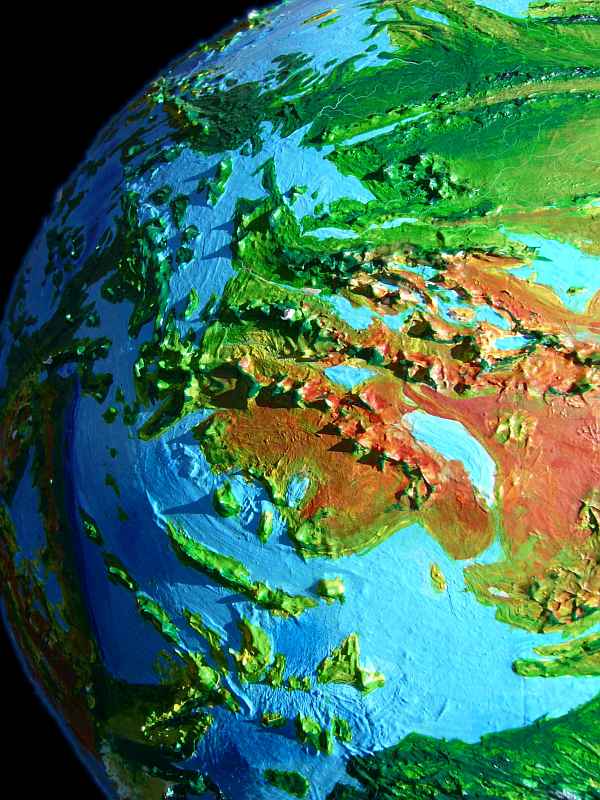
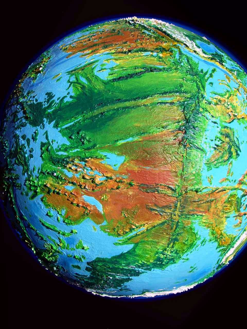
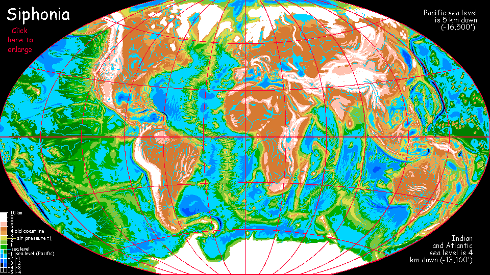
The Agassiz Ocean was once the southwestern Pacific. It's one of the largest remaining seas--a fairly compact, unbroken triangle of water as big as our Arctic Sea, over 12 M sq km (5 million sq mi). That comparison's a poor one: the Agassiz is not just warm, parts of it are hotter than any sea on Earth today. Though much of it lies in the high latitudes, the climate's still mild at 50-60 south and sauna-like near the equator. The reason? Sea level is very far down indeed, fully 5 km (3 mi) below ours. In this deep well, air pressure is 1.7 times normal, trapping heat, flattening temperature swings
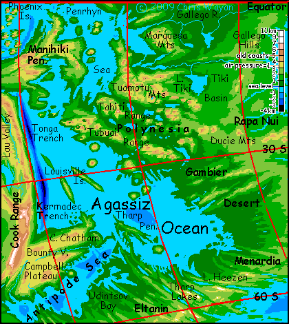
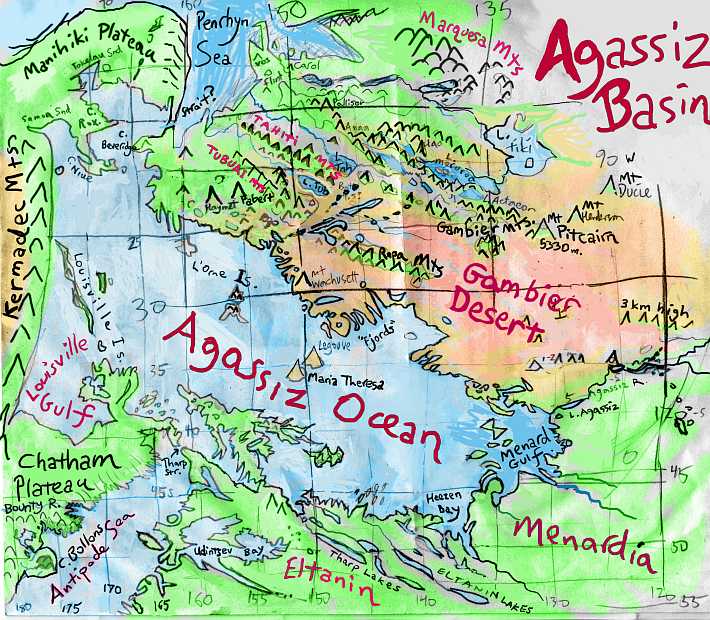
Let's circle the Agassiz Basin and have a look at its regions. I'm still constructing maps of this basin, since the sea floor here is one of Earth's least-known and worst-documented patches; the largest on Earth with not a speck of land.
To the left is a rough altitude map. Green areas have air denser than one atmosphere; yellow, roughly like our sea level; orange and above, thinner, mostly like Earth from one to two miles up. Remember, the colors do NOT indicate rainfall or vegetation! And the real coastline is far more complex; this is largely from late 20th Century soundings (i.e. not terribly accurate even before I oversimplified them).
THE EAST: TAHITI and the GAMBIER DESERT
The east shore of the Agassiz, south of the Polynesian Ranges, is dry and hot, the second hottest in the world (after the Clarion Desert). Prevailing winds here blow off the land; storms from the seas to the east rarely manage to cross the Ducie Mountains, culminating in Mt Pitcairn, 5330 m high (17,500'). The Agassiz Lakes, in a rugged fracture zone, are deep enough not to be seasonal, but only a few rivers here reach from the mountains to the sea. A series of jagged "fjords" cut this coast; low, barren ridges divide lush fingers of coral reef, something like the fingers of the Red Sea around Sinai, but dozens. Volcanic islands like Marie Therese and Legouve offshore are tall enough to snag clouds on their wooded shoulders.
Inland, a great lake may lie--with the emphasis on may. It pepends what season you visit in (and on my shifting moods). There's a large basin here, but evaporation's high; will it be marsh, inland sea, or mostly dried mud? I'm not sure. I've shown this huge, nameless lake at maximum; if you go traveling, don't rely on it for water. It probably won't be there--or will be small and brackish.
Further northeast, the coasts below the three great Polynesian Ranges would be scorching desert if the air pressure were like Earth's. These plains (and the valleys between the long parallel Polynesian ridges) still get no rain during most of the year; but in high summer, the desert air to the southeast heats and rises, sucking great storms from the Penrhyn Gulf (northernmost Agassiz); the mountains catch much of the rain, but enough gets through to sustain dry, open monsoon woods patchy with meadows (like the parts of the central Australian Outback), and replenish seasonal lakes and marshes. Though not all are seasonal: Lakes like Tubuai and Tahiti in the west, and huge Lake Moruroa in the east (600 km/370 mi long) are deep and stable; in the dry season, they're fed by delayed runoff in the form of springs from the Polynesian Mountains around them; last season's rains percolating through porous limestone, once coral reefs.
The Polynesian Ranges are as tall as our Andes in places; Mt Tahiti reaches 7100 m (23,500') and dozens of summits are 5-6 km (16-20,000'). Despite the hot dense air of the Agassiz Basin, making its climate quite unearthly, Mt Tahiti is so tall it reaches back into an older world, the thin-aired world of Earth--and its attendant cold. The Tahitian icecap isn't large, but it's the only one for thousands of kilometers. To the many species at its foot who've adapted to the new dense Basin air, it's an eerie, unclimbable beacon; might as well be Everest.
THE NORTH: MANIHIKI and COOK ISTHMUS
As we head northwest, past Mt Wachusett, a snowless but forested volcano 5 km high looming over the coast, the rains grow heavier and last longer. Mt Haymet and Mt Fabert are wooded to their feet; after this it's solid forest. No wonder. Past Cape Beveridge and around Manihiki Bay, the northern shores of Agassiz face fierce storms almost year-round. The mean rainfall's 2.5 meters (100"). It's sweltering, too, except for the Manihiki Highlands. Slopes on the western shore of Manihiki hold Siphonia's rainfall record--up to 20 m (nearly 800"), nearly double Earth's wettest spot on Kauai. The Manihiki uplands are a chain of ecological islands--former atolls and lagoons now high up, in a cool, mild, perpetual spring. Misty fern forests and meadows, but few running streams; like Polynesia, these coral-capped volcanoes are porous and cave-riddled. Waterfalls burst from their flanks lower down, where limestone ends and lava begins. And where most of the hurricanes unburden!
Here in the north is a momentous and uncertain spot: an isthmus dividing Agassiz Ocean from the Penrhyn Sea, the southernmost tongue of the Pacific. My original caprice creating this world of Siphonia involved sucking away most of Earth's oceans, starting from its deepest: the North Pacific. At first, then, all the seas would empty equally... until sills appeared. Now sills (dividing ridges) are inherently unstable. Evaporation lowers some seas, turning sills to isthmi; heavy rains feed other seas, turning sills to steady spills, eroding them... I've assumed that most of Earth's sills have become straits or isthmi. Here I think a ten-mile ridge separates the two oceans, both of which dropped a little more after the Big Slurp, as ice built up on the mountains of the Pacific Rim. But really there's no way to run an accurate simulation--too many factors. So I've set sea levels somewhat arbitirarily here (and elsewhere!) If I'm wrong here, then the Pacific Ocean is still essentially one. That'll have tremendous consequences for shipping, though probably less for communications and cultural spread--many of the new peoples of this dense-aired basin can fly, after all.
But for now, let's assume Cook Isthmus stands. The Agassiz is a separate pond, geographically, economically and culturally.
The sketch below, based on the newest data I've found, is still rough but gives some idea of the full complexity of the coasts and climates of the Agassiz, especially the east.
THE WEST: KERMADEC, LAU, CHATHAM, BOUNTY VALLEY
The western shore of the Agassiz is relatively simple: a brutal straight line, rising fron a deep offshore trench swiftly to the Kermadec Mountains, 5 km high. This mountain wall traps storms nearly as heavy as in Manihiki; the Kermadecs are clad in belts of steamy rainforest hotter than anything on Earth, through Amazonian rainforest, upland cloud forest, fern forest, and finally alps. The highest peaks get some snow in winter, especially in the south, but have no permanent ice. The back side of the Kermadecs, in Lau Valley, is open dry grassland, with trees only along the Lau River and a few lakes.
The rugged, spectacular Louisville Islands have varied climates. If you don't like the weather, just climb, for these huge whalebacks rise 3-5 km from sea level, from hotter-than-tropical shores to temperate heights; the southernmost even see some winter snow.
The cooler highlands of Chatham and Campbell and the Bounty Valley are even more like Earth's cool-temperate zone; winter is harsh, especially in Chatham. Since the air in these uplands is as thin as on our Earth, they're the one area that lacks the distinctive flying species of the Agassiz Deep (see Life in the Agassiz below).
The highest reaches of this great upland are of course the mountains of former New Zealand. Most of the former islands have iced over; Mt Cook is nearly 8700 m (28,500') high, rivaling Everest. A broad apron of alpine meadow--once shallow sea--surrounds the Long White Ice.
THE SOUTH: ANTIPODES, ELTANIN and MENARDIA
You'll notice how different my various modeled coasts in the south are. A lot of the land hovers near sea level, so coastlines are uncertain. Despite the drama of the orbital photo to the right, I may be forced to revise it in light of more accurate depth soundings. The sketchmap above is closest to final, based on recent data: it shows a nearly-separate sea, the Antipode Sea, in the far southwest, under the mountain walls of Zealand and Mt Scott. Despite the far-south latitudes (well past sixty!) the climate's mild down by the shores: the dense air traps warmth. But winter snows get deep in the hills.
Eltanin, for example, the warm-temperate south shore of the Agassiz, is almost European; if not for the creatures flapping around in that dense air, it could almost be France.
Menardia, in the southeast, has a gentle Californian climate down by the coast. Even the topography's milder. Instead of the savage volcanic verticality of the north, or the pseudo-fjords common along other stretches of this great rift zone, only a few great fossae (linear canyons) and attendant pine-clad ridges break Menardia's broad, grassy, oak-dotted plains. The few fossae are classic: cliffwalled and lake-bottomed, running thousands of km: the longest, Udintsev, is a natural highway pass through the Rift Mountains between the Agassiz Basin and the Mornington Sea, a thousand km southeast--and a kilometer higher.
In Menardia, if you ignore the geological origins of the features around you and squint your eyes, you could convince yourself you're on America's west coast, or parts of Australia. Until one of the local people flaps by...
Which leads us to our next topic.
LIFE IN THE AGASSIZ
The Agassiz is one of only two seas fully 5 km below the old sea level. Beside trapping heat, the high air pressure blocks ultraviolet, supercharges lungs and brains, and provides extra lift, making flight easy. Even quite large mammals glide on skin flaps from tree to tree, and many fly.
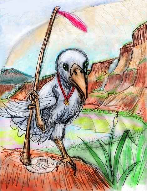
Including the people. No, not humans. In the north at least, it's too hot for them: up to 50 C (120 F) and 100% humidity! The dominant species along these steamy shores will be giant parrots. Even our parrots are as bright as chimps, though it took until this decade for the evidence to finally overcome mammalian scientific prejudices. And they manage it with brains weighing only ounces. Despite human insults, bird brains beat mammal brains for efficiency by a very wide margin! They have to.
But the dense air of the Agassiz basin supports fliers as heavy as 25 kg (55 lbs). Most parrots are only a bit over half this, but that's quite large enough for them to have brainweights approaching a pound. They're just as intelligent as a human--perhaps more so. Ask them. They'll tell you. These megaparrots are imposing creatures in other ways as well: brilliantly colored, with much deeper (but still operatic) voices, and wingspans up to 4 meters (13').
Equally imposing are their distant cousins: megaravens. They're even less recognizable, for in these hot basins, black feathers were a sun-absorbing disadvantage; as they grew, they lightened in color, ending up looking more like their close cousins the jays: various mixtures of gray, blue and white. But they're unmistakable: huge heads, rich but hoarse voices, playfulness tinged with a dark irony... really, they haven't changed a bit. A useful tonic to anyone grown tired of parrots' loud good cheer (punctuated by equally loud prima-donna tantrums).
But fliers aren't the only creatures who have grown larger, with startling consequences for brain size. For an example I'll use the species you're most likely to meet here in the Agassiz: a newly evolved people who cope with the heat and humidity in a different way, by hardly coming out of the water, in the day at least. You see them in every port and river town: those big wet furry things chirping at you and wiggling their whiskers. They're descendants of giant freshwater Amazonian otters, of course.

Their quick evolution was one of those unpredictable consequences of radical environmental change. Recent studies show that the size of animals and the number of species (and probably total biomass, too) correlate well with the oxygen content of the air. Earth's atmosphere has varied greatly over its history--in the last billion years alone, it's ranged from 13 to 30% oxygen! While the percentage of oxygen on Siphonia isn't much higher than on our Earth, the many dense rainforests in the deepest basins like Agassiz have pushed it higher, to about 22%--one tenth more than on Earth. Not too significant biologically. However, that's merely the percentage. Down in these deep high-pressure basins, available oxygen is about 185% of Earth's--a bigger change than animal life has seen since brains evolved! All that extra oxygen makes it much easier for an animal to grow larger--OR to maintain large specialized, oxygen-hungry organs. Like brains! They're the costliest organ of all, pound for pound--hogging both calories and oxygen. In an environment where food isn't too hard to get--and these lush coasts qualify--it turns out that supercharged air has freed many nonflying species to grow much larger and more intelligent. Amazonian otters, already big and bright, apparently crossed a crucial threshhold: social intelligence, the ability to understand, predict, and influence other creatures' behavior, became more important as they got less predictable. A spiral of brain-growth ensued, rather quickly tripling brain-size... just as it had in humans and dolphins.
Other than scaling up, they haven't changed much, physically. The main adaptation is to heat: they're gracile, that is, slenderer, with longer limbs. More surface area per pound means a cooler otter: more evaporative heat dispersal when they're on land--or in bloodwarm water.
While human intervention was essential in their appearance here, humans didn't breed or genetically engineer them--they just built the wagons (or railroads) that carried otters seeking dockside and fishing jobs (or just curious types, intrigued by tales of the Pacific Deep) across the Pagatonian Steppes, or over Orkney Pass near Antarctica, or via the Managua and Colorado Canals, or over Macquarie Pass south of New Zealand, or over Marion Pass and through the labyrinthine Anzac Lakes (the simplest five ways to cross into the Pacific--none of them easy). Their descendants naturalized, and are found all over the warmer parts of the Pacific and Agassiz basins. Originally tropical, these otters are adaptable; some are now found along the Aleutian coast, and even the Bering Sea above 50 north. It's much warmer than our world would be, of course--air that dense guarantees it never snows, not at 50, and rarely at 60--but they've a long way from muddy tributaries of the equatorial Amazon.
Of course, mentally they've come further still; from animals to people in a geological blink.
And their immigrants' tales could be echoed by orangutans and other great apes. Though the arctic wolves who spread south and were shaped by abyssal conditions into much smaller, lighter, smarter gliderwolves... they did it all on their own, as did the gracile elephants, the giant parrots, the ravens...
|
|
Siphonia's homepage - map - peoples of Siphonia - Siphonia's evolution - Gazetteer
LISTS AND LINKS: More worlds? Planetocopia! - dreams of other worlds - ecology - climate change - evolution - natural disasters - terraforming - sculptures and 3D art - Meet the original Louis Agassiz, fossil hunter and dreamer: Agassiz's Fish
World Dream Bank homepage - Art gallery - New stuff - Introductory sampler, best dreams, best art - On dreamwork - Books
Indexes: Subject - Author - Date - Names - Places - Art media/styles
Titles: A - B - C - D - E - F - G - H - IJ - KL - M - NO - PQ - R - Sa-Sk - Sl-Sz - T - UV - WXYZ
Email: wdreamb@yahoo.com - Catalog of art, books, CDs - Behind the Curtain: FAQs, bio, site map - Kindred sites