World Dream Bank
home -
add a dream -
newest -
art gallery -
sampler -
dreams by
title,
subject,
author,
date,
places,
names
Siphonia: Amazon Plateau
by Chris Wayan, 2006-9
Siphonia - map - regional tours - People, Creatures - Evolution - (don't click yet: Gazetteer - Glossary) - more worlds? Planetocopia!
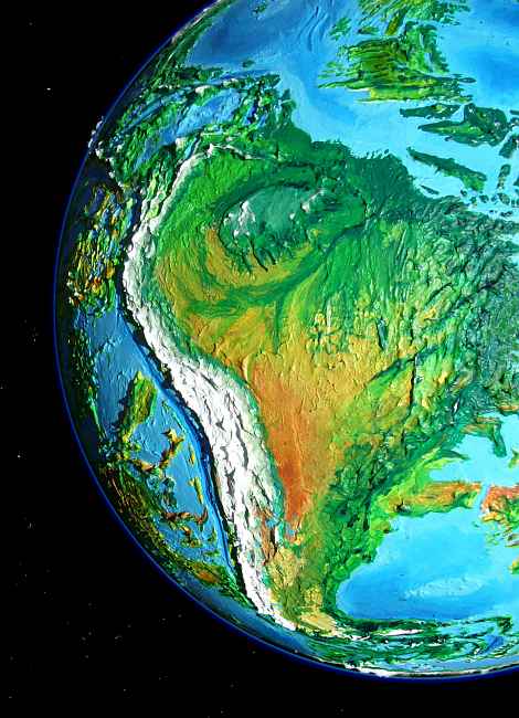
AMAZON PLATEAU
These days, Amazonia is South America--at least, the living parts. All the Andes, the altiplano, and even parts of Roraima and the Brazilian coastal ranges are icecapped or alpine tundra. After the Big Slurp, the Amazon Plateau is over 4 km (13,000+ ft) above sea level--though the Atlantic and eastern Pacific aren't what they used to be either, of course.
Amazonia's altitude might suggest it's as harsh as our Tibet or Altiplano, but it's not. The new sea basins are narrow, and filling them takes less air; so the atmosphere, warmth, rain, and life have crept down the continental slopes, but less than you'd think. Climatically the Amazonian basin is like a Terran highland 2200 m up (7200'), not 4000 (13,000'). Since the plateau straddles the Equator, much of it has mild springlike weather year-round, rather like parts of our Ethiopia or hill stations in Sri Lanka. Less rain falls, but it's still quite ample for a mixture of forests and farms. In fact, the population's denser than on Earth. But by Siphonian standards it's monotonous: mostly human descendants of Andean people, plus a few Amazonian otters (most prefer the warm lowlands of the Atlantic Deep to this, their ancestral home). The air's just too thin to be comfortable for intelligent fliers like the megaravens and giant parrots who liven up the cultural mix in the Atlantic Deep to the east. Still, Amazonia today is a prosperous farmland... if a bit stodgy.
Amazonia's not the only such fertile upland on Siphonia, but it's the certainly the archetype: central Africa is drier, mostly farmable prairie; Arafura (a former shallow sea just north of Australia) is equally fertile and densely populated but smaller and not a former continent at all, but a shelf left (very) high and dry; and the Indonesian highlands are mostly fertile but a tangled complex of former lands and seas. But this great forest changed as a unit.
Change does not mean death. Yes, the climate suddenly cooled and dried, favoring trees and animals from the hills and pampas over the native rainforest. But they didn't all die out; the incredibly complex mix of our Amazonia has simplified but not disappeared. And many species that really needed heat and rain still didn't go extinct; like the otters, they just migrated downstream to the warm dense damp air of the Ceara and Pernambuco Deeps, down at the new sea level.
 "Go east, young tree!" Or at least seeds. In a sense, the whole Amazon rainforest simply packed up its roots and fled downstream. In fact, fanning out from the Amazon delta, it conquered a bigger, hotter, rainier basin than Amazonia ever was: the Atlantic Deep.
THE SKY ISLAND OF RORAIMA
The Roraima Plateau is the source of the tallest waterfalls on the planet; cliffs rise as much as 2-3 km (6600-10,000') above Earth's sea level. But on Siphonia the heights are 6-7 km up (20-23000'); air pressure and temperatures are kinder than they would be on Earth at that height, of course; more like 42-5200 m (13,800-17,000'). Though they nearly straddle the equator, the highest two ranges have ice, and the old cloud forests are gone; most of Roraima's now above the clouds. Alpine and subalpine meadows and dwarf forests.
The waterfalls are still there, though far colder: snow-fed.
Most of the population is quadrupedal. A few Andean humans relocated here--it's not quite the old Altiplano, but the air and light and open horizons at least echo that lost Andean world, now under ice--but most Andeans today farm the Amazon and Orinoco plateaus below Roraima; an easier life. Roraima is mostly left to two species who can browse on its meager flora directly. Both are immigrants from the Andes: llamas and mammoths.
THE SOUTH
To the south of the great Amazon plateau, Paraguay is near-desert, for it lies in the rainshadow of the Brazilian coastal ranges; in the thinner air, most storms don't make it over the mountains. Think Wyoming, and not the mountainous part: endless sagebrush and sparse bunch grass.
Further south, the Plata River in Uruguay and northern Argentina is greener, since the mountains don't block the rains. It's a forested plateau of dark pine, golden aspen, blue spruce, dotted with lakes. The trees thin steadily to the south: prairie, warm in summer but hard-frozen in winter, with thin dry air year-round. Alberta, Saskatchewan? Close enough.
Even further south, Patagonia's as bad as Northern Canada: cold, windy, treeless. Near-tundra.
In the extreme south, beyond this dreary plateau, the land drops abruptly into the Scotia Basin, a fascinating subpolar oasis--an oceanic Deep in miniature, with a mild climate despite its latitude. But it's a long, hard trek: the Southwest Passage. And like our Northwest Passage, it's more mythically resonant than practical; the kind of route that kids all read and dream about, but never really tread. No profit in it. Unless the Amazonians or Scotians advance to the point they can build a railroad.... I can see the two lines meeting a few hundred km east of Bariloche, as they drive in the Golden Spike. Ironically, the Scotia crew will be mostly giant Amazonian otters who find their native continent cold and alien, while the Amazonia crew is all human--former Bolivians chewing coca. The otters will get hooked too; the only way to work in that relentless cold wind.
The fallout from this noble project? Otters on cocaine. Gives me shivers. Manic piled on manic... whew!
I'm not sure where the Southwest Passage's least-wretched pass lies. The shortest is Drake Pass, through the Fuego Mountains, but at best it's snowed in most of the year and may be glacier-choked--useless for a road, or rails. Southeast between the Malvina, Burdwood and Fuego Ranges lie a couple of longer routes half a kilometer lower; and through the Yaghan Mts, several hundred km further east, passes 12-1500 meters lower than Drake (4-5000'): heavy winter snows, but merely alpine; no glaciers. Passable in summer, though still not easy.
THE WEST?
The south is rough, but the west is worse. To Amazonians, it's the edge of the world. Siphonia's Andes aren't like our modest Rockies (broken mountains with small glaciers, easy to pass--notice it was the unbroken wall of the Sierra Nevada that Gold Rush pioneers starved trying to cross!) To the west, Amazonia just ends in a solid ice-wall rising 8-11 km (26,000-37,000'!) above the new sea level. It's a worse barrier than our Himalayas; most of the Altiplano is an icefield now, hundreds of km wide in spots. There are no passes at all fit for travelers and traders; most passes have temperatures and air comparable to over 6000 m (20,000') on Earth.
It's true that young, crazy-adventurous native Uplanders, bred for thin air, can and do occasionally cross the ice to the Pacific Deep on foot or sledge, over the very lowest passes, Chira in southern Ecuador (air like 4500+ m/15,000') and Cutervo in northern Peru (air like 4000+ m / over 13,000'). Cutervo is low enough not to be glaciated if it weren't at the edge of the Huascaran Icefield. But ice breeds ice; glacial tongues fed from above will choke the pass. And you can't build railroads on ice. It moves! Even if you could clear a track through, the new Deep-adapted species couldn't ride in ease in heated Pullman cars, gawking out the windows at the glaciers. They'd die of anoxia. To them, these heights might as well be the stratosphere.
So Amazonia and Patagonia (culturally and economically) look east to the Atlantic basins. To the west, their world simply ends.
TOUR SIPHONIA! Click a region above, or choose from:
- Arctic Valleys, sea level to 3 km high
- Atlantic Ocean (our N. & S.E. Atlantic), sea level
- African Ocean (S. Atlantic & W. Indian Ocean), sea level
- Bengal Sea (N. Indian Ocean), sea level
- Australian Ocean (E. Indian Ocean, Tasman Sea), sea level
- Davis Sea (S. Indian Ocean), sea level
- Anzac Basins (N.Z. to Australia), 0.5-2.5 km high
- Mornington Sea (S.E. Pacific) sea level
- Nazca Seas (E. Pacific), sea level to 1 km high
- Agassiz Basin (S. Pacific), 1 km down
|
|
- Pacific Ocean (N. Pacific), 1 km down
- East Asian Seas, 1-3.5 km high
- Javan Seas, 0.5-2.5 km high
- Australia, 4-5 km high
- Amazon Highlands and Andean Cap, 4-8 km high
- African Highlands, 5-6 km high
- Antarctic Cap, 4-5 km high (no, not 7-8!)
- European and Siberian Highlands, 4-6 km high
- Caribbean Lakes, 2-5 km high
- Canadian Highlands, 4-6 km high
|
Siphonia's homepage - map - peoples of Siphonia - Siphonia's evolution - Gazetteer
LISTS AND LINKS: More worlds? Planetocopia! - dreams of other worlds - ecology - climate change - evolution - natural disasters - terraforming - sculptures and 3D art -
World Dream Bank homepage - Art gallery - New stuff - Introductory sampler, best dreams, best art - On dreamwork - Books
Indexes: Subject - Author - Date - Names - Places - Art media/styles
Titles: A - B - C - D - E - F - G - H - IJ - KL - M - NO - PQ - R - Sa-Sk - Sl-Sz - T - UV - WXYZ
Email: wdreamb@yahoo.com - Catalog of art, books, CDs - Behind the Curtain: FAQs, bio, site map - Kindred sites