Siphonia:
ANZAC BASINS
by Chris Wayan, 2006-(
Siphonia - map - regional tours - People, Creatures - Evolution - (don't click yet: Gazetteer - Glossary) - more worlds? Planetocopia!
INTRODUCTION
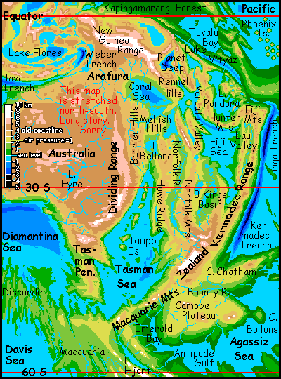
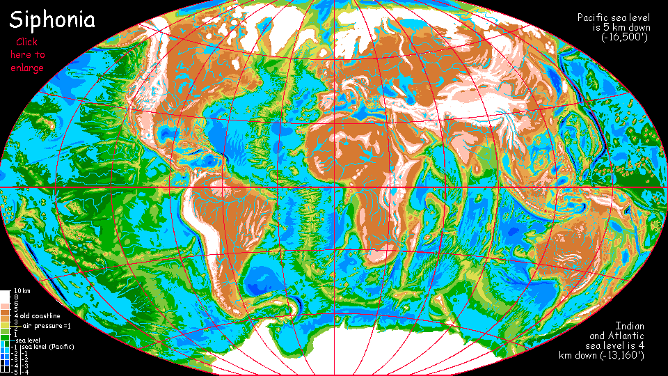
Earth really has eight continental masses, not seven. The eighth is hidden under shallow seas in the Pacific, centered on New Zealand; great ridges and plateaus stretch to Australia, Fiji and Antarctica.
Exposed on Siphonia, these "Anzac Highlands" are a complex triangular mass of plateaus, ranges and basins, with seas and freshwater lakes at all altitudes. Don't let this pitted landscape fool you into seeing it as non-continental; our familiar continents have just been smoothed by eons of above-water weathering, which turns most such lake-basins into plains. But on Siphonia, a mere 90,000 years has merely let life settle in here. Rains in much of Anzac are light, so erosion's slow. In ten million years we'll see a quite Terran continent, with an Andean range on the east, central plains where the Kings Lakes and the Fiji Sea are now, and a northwestern basin-and-range region much like the western USA.
Give Anzac time! Life is swift, geology's slow. In the meantime, enjoy the lakes. The locals do. Indeed, as we'll see, the northwestern lakes are the source of more than local prosperity: they're the lowest-altitude route between the Pacific and the Australian Oceans--between hemispheres.
SOUTH ANZAC
Climates in Southern Anzac range from icefields on the Cook Range (covering quite a bit of the former New Zealand, in fact) and tundra around Lake Hjort and on the Campbell Plateau (where New Mammoth graze), to lush rainforest on the east coast below the Kermadec Range.
Despite the Cook Icefield, not all the highlands around ex-New Zealand are cold; the Bounty Valley, Emerald Valley, and Cape Chatham are wide temperate lands, heavily settled by humans (and others, like megaravens, who don't mind winter snow).
The shores of Emerald Bay, Antipode Gulf and Cape Bollons, despite their proximity to Antarctica (over 50 south) are low enough to have air much denser than Earth's: hence their mild snowless winters. Here can be found Siphonia's southernmost villages of megaparrots and otters. You'll even run into a few Deep gorillas in the otter bars along the docks; winters are a bit dark and cold for them, but there's good work loading lumber for export.
Even the slopes flanking the subpolar Macquarie Range aren't so bad: cool-temperate, with conifer forests broken by small farms--human and raven-run, though the ravens grow rare at higher elevations. They don't mind the snow; it's just that they're too big to fly comfortably in the uplands, where the sea-basins' dense air thins to something reminiscent of Earth. However, they can cross the Macquaries at Emerald Pass and thus travel between the Tasman Deep (a tip of the Australian Ocean complex) and Emerald Valley (a finger of the vast Agassiz Deep). For ravens (and parrots, and gliderwolves, and nonsentient abyssal creatures too) it's a strait of flyable air between hemispheres; their Panama.
But only for fliers, there will never be a canal here for shipping. Emerald Pass is still nearly a mile high on the Tasman side; even higher above the Antipode Sea.
CENTRAL ANZAC
North of New Zealand is a large semi-arid zone. Parts of the long Norfolk Valley, Kings Basin and Lau Valley are savanna and even desert, though with a mild climate by our standards--the dense air mutes temperature swings and holds moisture. And the many streams descending from the Norfolk and Howe Ranges supply year-round drinking water for grazing herds, and irrigation water for farms on the valley floors along the Norfolk River and the shores of its several long lakes. It's as patchy and unpredictable land as our East African lake country--utterly different climates every hundred km, as altitude and rainfall plummet and leap. And for once, the reason's similar: youth. East Africa's a new continent splitting off, full of adolescent tectonic vigor, where erosion hasn't had time to smooth things out. Anzac's just as active, and freshly bared; here erosion's barely begun its long job.
The Fiji Sea is the heart of Anzac. Its size, twisted shape, and above all the varied but summer-drought-adapted vegetation on its shores, are all curiously Mediterranean, though winters are milder; the frost-free zone extends further up the hills, especially in the west.
The eastern rim of Anzac is higher and cooler: here twin ranges, the Kermadecs and the Laus, rise into a zone that (in the south) gets winter snow. The long Lau Valley between them isn't Mediterranean at all; cut off from sea-winds, this cool dry valley is high grassland, a slice of fire-adapted prairie--summer thunderstorms are fierce. Rains are irregular, but substantial; trees constantly try to settle the Lau, rising triumphantly until the lightning burns them back. Grass wins.
The north shore of the Fiji Sea is an ecological exception too: here the Hunter Mts catch the monsoon winds each summer and squeeze rain from them for several months; their southern slopes are tall, rich forests. But the long dry winter is mild and the beaches warm. The Yalta of Anzac.
NORTH ANZAC
Northern Anzac is just as vertical as East Africa, too. The Caledonie Mts rise like an upturned keel some 4500 meters above the Norfolk River and Lake Chesterfield; nearly 6000 above the Coral Sea (19-20,000'). To their northeast, the Vanuatu Range also rises to 5800 m. Both these ranges are high enough for snow, though their alpine regions won't be extensive, given the warm dense air in the region. But they're nearer the sea than Kilimanjaro or Ruwenzori or Mt Kenya; much moister air. So my bet is on snow, deposited not in winter but mostly summer, as snow flurries during treacherous thunder/hailstorms.
Don't miss the Vanuatus--the range rises straight from a long deep sound, a northern finger of the Fiji Sea. A spectacular sight.
In the northwest, the Coral Sea shores and the Bellona and Mellish Hills are open monsoon woods with meadows here and there, prone to drought but torrentially wet in some years. Lake Bellona is caught between the Coral and Tasman Seas climatically as well as geographically: a very mixed, Mediterranean climate with irregular rains.
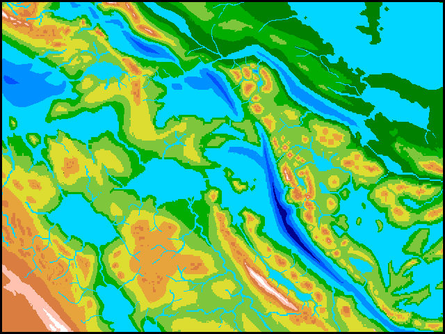
This region thrives on shipping, for here is found the nearest thing to a canal between the Australian and Pacific Oceans. Take a deep breath...
All you need to do is sail up the Tasman Sea to the head of Middleton Bay, and upriver to Lake Bellona. From here, sail up Chesterfield or Marion River as far as you can... and then portage. Sorry, no canal. I can't tell if Marion Pass or Chesterfield is lower, but both are over 1000 meters (3280') and may be more like 1200 (4000'). Say Marion Pass is lower--that's my best guess. Then you may be able to load your goods on a railway at Port Marion, if the technology's up to it, cross the pass to Lake Coral, reload yourselves and goods onto another vessel, sail down the Coral River to Lake Sable...
Or if I'm wrong and Chesterfield's lower, we can avoid Lake Coral and head directly east to Lake Sable by foot, caravan or rail...
Now it's simple. We descend through a lake- and river-maze: Lakes Sable, Hebrides, Torres, Vityaz and Tuvalu, each a hundred or two meters lower, until we reach Tuvalu Gulf on the Pacific Ocean, over 2 km below the passes. That's one km below our starting point on the Tasman Sea; for the Australian and Pacific Oceans aren't at the same level.
Complex though this is, it's by far the simplest way to ship items between hemispheres. We fail to remember how unified Earth is by those ubiquitous, sailable seas. You can get nearly anywhere on earth with pre-industrial technology! Siphonia is different--relentlessly local, walled off into regional trade-basins.
Northeastern Anzac is a mountain-rimmed plateau, caught between two trench systems, the Vityaz and the Vanuatu; a small tectonic plate of its own. The mountains block most storms; although Lake Pandora fills much of the basin, its shores are savanna and open monsoon woods.
In the far north is Vityaz Trench, a subduction zone higher and more broken than most. Lakes fill much of its floor. The east end is drained by the Samoa River, the west by the Vityaz. The great river in the southeast is the Lau, whose headwaters are still a couple of thousand km to the south, past the Tonga Mts, near Zealand.
Here's a rough altitude map. No names yet... The huge orange arc in the center is the Fiji Range, which rears above the clouds entirely; indeed a couple of peaks sometimes bear snow.
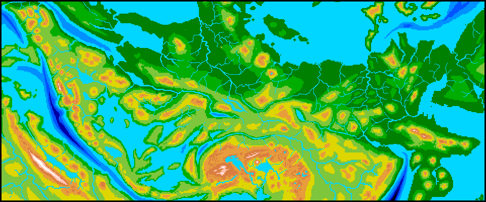
People here build low and light: both quakes and hurricanes! It's even stormier to the north around Tuvalu Gulf. The Gulf, and the Pacific shores beyond it, are a kilometer below any land in the old Indian or Atlantic basins; the superdense air creates a jungly steambath intolerable to humans. But Amazonian otters and megaparrots do well here, in waterfront and treetop villages, a pattern we'll see all in the rainforests all around the new, shrunken Pacific.
To the east the trench frays into several finger-canyons winding between sinuous mesas three miles high. Two climatic worlds in one, with little between them. Arizona or Roraima? More the latter; rains are heavy here. At least on the northern edge--but mountains this high do a good job of blocking typhoons. Valleys grow progressively drier to the south, until the upper Lau Valley at the bottom of the map is treeless prairie, even high desert. A strange stream, flowing from Nevada down into the Mesozoic.
|
|
Siphonia's homepage - map - peoples of Siphonia - Siphonia's evolution - Gazetteer
LISTS AND LINKS: More worlds? Planetocopia! - dreams of other worlds - ecology - climate change - evolution - natural disasters - terraforming - sculptures and 3D art -
World Dream Bank homepage - Art gallery - New stuff - Introductory sampler, best dreams, best art - On dreamwork - Books
Indexes: Subject - Author - Date - Names - Places - Art media/styles
Titles: A - B - C - D - E - F - G - H - IJ - KL - M - NO - PQ - R - Sa-Sk - Sl-Sz - T - UV - WXYZ
Email: wdreamb@yahoo.com - Catalog of art, books, CDs - Behind the Curtain: FAQs, bio, site map - Kindred sites