Siphonia:
ARCTIC BASINS
by Chris Wayan, 2006
this page is still in progress
Siphonia - map - regional tours - People, Creatures - Evolution - (don't click yet: Gazetteer - Glossary) - more worlds? Planetocopia!
INTRO
The Arctic is paradoxical: both colder and warmer. How can this be? Well, as the Arctic Sea receded, it broke up into several salt lakes deep in their polar basins. Some of these are low enough, and air pressure is high enough, that temperatures are warmer than on Earth. But the highlands around them--Siberia, Canada, Greenland--are thin-aired and harsh; let's proceed with caution. There is only one easy approach to the North Pole these days: the North Atlantic, around Iceland. On the far side of the world, the Bering Strait is a high pass, ice-free only in August most years, like all Alaska.
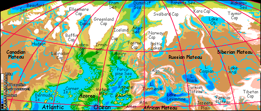
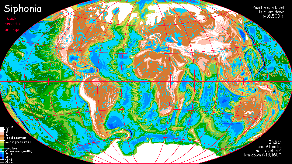
But before we push north to those bizarre polar basins, let's have a look at the lands around the hole in the top of the world. This North Atlantic/Siberia map shows the surrounding icecaps.
It's arguable that these caps should merge into one or two great icefields, as they do in our Ice Ages. I've kept them smaller and separate for a couple of reasons: ice normally builds up only until the top of the ice-dome is in thin air, about half the pressure at sea level; precipitation at that altitude is usually small and offset by the flow of the ice outward. On Siphonia's continental platforms, the air is much thinner; the limit is reached much sooner, so individual caps aren't under nearly as much pressure and don't spread as much. They grow mostly from precipitation not creep. But nearly all the precipitation is near the coasts, which have receded; inland Siberia and Lake Hudson may be cold enough to sustain icecaps, but a bit too dry to build big ones.
Still, you could build a convincing case for a thin but permanent ice sheet over the whole Siberian plateau, and much of the Russian and Canadian plateaus as well. Either way, it's pretty grim territory--cold, treeless steppes with relentless winds off the ice.
Only one people could live here: mammoths. Yes, they're back, though smaller, with a more cunning handlike trunk. And tools. And fire. Even so, this vast territory supports only small nomadic bands, and they're snowbirds, migrating south in winters to huddle on the marshy shores of the huge chain of Central Eurasian lakes: Balkhash, Aral, Caspian, Black, Levantine, and Tyrrhenian. Some herds may migrate from summer pastures on alpine plateaus like Spain, Persia and Turkey down to winter on grassy plains like Jazeera and Adriatica; not snowfree, but at least not flash-frozen.
The North Atlantic valleys from Labrador to Britain are also warmer and more sheltered: cool-temperate? These valleys, Labrador, Irminger/Imarssuak, Gadrar, Maury, Rockall, and Goban, together form perhaps the largest region on Siphonia that's midway between the new sea level and the old, having an Earthlike air pressure. Judging by that and their latitude, their climate should be much like France. It won't be, though; Greenland and the new secondary caps of Scandinavia, the Faeroes and Iceland will give these valleys colder weather. The question is: England, or Norway?
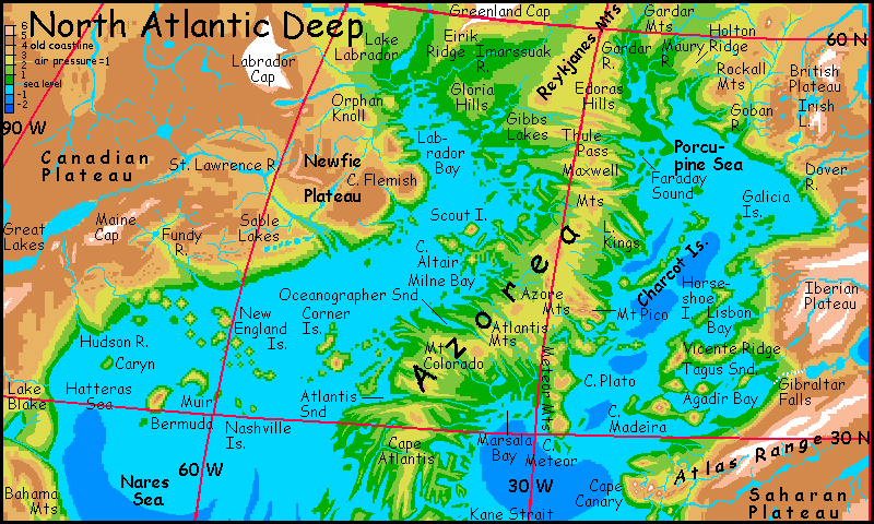
Or maybe the British will just go on cursing the weather and carrying umbrellas, in the streets of New London on the Maury or Rockall River, a thousand km west and over two km below the poor old Thames, where caribou wade (in the few months when it's not iced over). Either way, bears or barristers (or bears who are barristers, let's not be specist), these valleys will be an interesting land--mild, green and fertile, yet right below the ice. And not the only place of this sort: consider the new cooler India below the Tibetan icecap, or Amazonia below the great ice wall of the Andes! It's a juxtaposition inconceivable on Earth today--though twenty thousand years ago there were rich grassy steppes right up to the edges of the ice in many places.
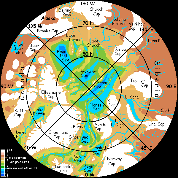
Now you get the basic dynamics--at least as I understand them. To the right is a first-draft map of the polar basins. It doesn't entirely agree with the North Atlantic map; probably this one's closer to final.
The deep polar basins are another world. Their climate is contradictory: glaciation on the surrounding uplands is more extensive--two or three Greenlands, at least!--but the old seabasins are lower; their air is denser and warmer than our Arctic. The result depends on HOW much lower the arctic seas are. During the Big Slurp, much of the our Arctic Sea drained out past Greenland into the lowering Atlantic, but that only lowered the polar sea level a kilometer or so. However, polar climate is dry, so my best guess is that evaporation will slowly shrink this cut-off Arctic Sea until it splits into a complex of small seas much deeper in their basins.
At what level will these be stable? It's hard to know, and will vary according to precipitation and inflow from surrounding rivers. This may be pretty small at first, since the Big Slurp causes the air pressure to drop and the climate to grow colder. But over time, as the seas fall, the air will grow thicker again. If the water level drops enough, air pressure will rise past 1 atmosphere, and the denser air will trap heat.
The result is probably, on average, deep sea-basins with milder temperatures than our Arctic, surrounded by substantial ice-capped highlands. Both hotter and colder at once! The shallower basins will feel polar, even Antarctic; but the deepest basins will feel Scandinavian or Canadian, not Arctic.
Rain? While our polar region is generally dry, these deep basins with their denser air, warmer temperatures and unfrozen surface water will generate more rain. Coasts will be fertile tundra, not barrens; coasts of the lowest basins may even have boreal forests. Trees at the Pole, for the first time in fifty million years!
The details are still in progress, as you can see from the tentative close-up map of the Arctic basins, below.
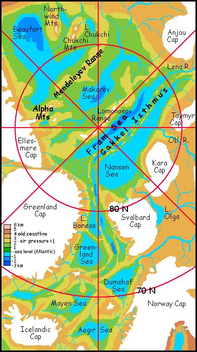
Note the strange rift valley forming a long isthmus between the Fram and Nansen Seas. It's called Nansen Ridge on most maps, Gakkel Ridge on some recent ones; but either name's deceptively oversimple. Twin ridges flank a valley so deep it'll be flooded most of its length. Indeed some of its low points are 5 km below our sea level, about the lowest points in the Arctic; they'll be deep water no matter how far Siphonia's seas subside. But a chain of freshwater lakes like our Lake Baikal, or one long narrow sea, or sounds flooded by the Fram or Nansen Seas? I don't know; possibly all of them in different stretches. On NOAA maps the region looks very rugged and confused, with side-holes and cones--volcanoes? It resembles East Africa's rift valleys, or Venus's chasmas, and both of those sport lots of associated vulcanism.
The Nansen or Gakkel Isthmus, surrounded by seas, will be the rainiest place in the north, and volcanic ash will build its soils. I expect rich boreal forests, berry-bogs, and meadows on the heights--a new Alaska, really. But this far north, the seasons will be strange indeed: half a year of perpetual light, half of darkness.
The Makarov Basin, also snuggled up against the North Pole, and more isolated behind the rugged Lomonosov Range, is probably deeper. The rivers feeding this basin are much smaller, proportionate to its size, than the Fram or Nansen Seas, fed by the huge Lena and Ob' Rivers. So the Makarov Sea may lie more than three km below our Arctic. The dense air at this depth will keep the Makarov shores warmer on average than the Fram and Nansen basins, but more continental, with harsher winters--Siberian. Trees? I'm not sure. But I think so--right at the pole!
The last basin, and the largest, is shallower again, 2.5 to 3 km deep; the mighty Mackenzie and the Passage River (draining the old Northwest Passage and much of former Nunavut) feed the Beaufort Sea and keep it from shrinking further. The land is like northern Alaska, with large trees only in sheltered spots along the southern coast (top of map; remember you've passed the pole now). Sweeping arctic meadows, braided silty rivers and craggy mountains--not heavily glaciated, for this basin too has strong temperature swings that tend to melt snowpacks by late summer, though only briefly. The rugged Northwind and Chukchi Valleys are spectacular, but time your trip carefully to avoid the bugs.
In late summer we climb south out of the Arctic Basin over icy Bering Pass to the Pacific Basin--more exactly the Bering Basin, a cool but solidly forested lowland north of the towering Aleutian Range. As you descend from the tundra's immense vistas into those claustrophobic forests, you don't care what the map says about your latitude--you've left the Arctic.
You crossed the pole--eating berries all the way.
I did warn you Siphonia was strange.
|
|
Siphonia's homepage - map - peoples of Siphonia - Siphonia's evolution - Gazetteer
LISTS AND LINKS: More worlds? Planetocopia! - dreams of other worlds - ecology - climate change - evolution - natural disasters - terraforming - sculptures and 3D art -
World Dream Bank homepage - Art gallery - New stuff - Introductory sampler, best dreams, best art - On dreamwork - Books
Indexes: Subject - Author - Date - Names - Places - Art media/styles
Titles: A - B - C - D - E - F - G - H - IJ - KL - M - NO - PQ - R - Sa-Sk - Sl-Sz - T - UV - WXYZ
Email: wdreamb@yahoo.com - Catalog of art, books, CDs - Behind the Curtain: FAQs, bio, site map - Kindred sites