Siphonia:
THE ATLANTIC DEEP
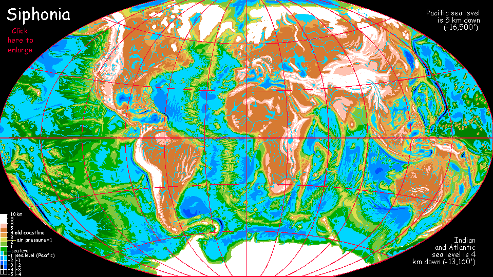
by Chris Wayan, 2006-9
Siphonia - map - regional tours - People, Creatures - Evolution - (don't click yet: Gazetteer - Glossary) - more worlds? Planetocopia!
ATLANTIC DEEP: OVERVIEW
This is just an outline for a full tour of this huge Deep--few orbital photos yet, and no sketches of scenery or portraits of the creatures at all. Eventually, I promise--I'm sketching and finishing the globe right now (spring 2009). My atlases disagree on names of some undersea features. And on what the new coastline would be! I have to make some judgment calls, that's all...
Are there firm assertions I can make about the Atlantic Deep at this point? Some. Sea level is four km below ours; air has pooled in this low basin, so the pressure at sea level is 1.5 to 1.6 Earth atmospheres. That air traps heat: it's at least 8 C (14 F) warmer than similar latitudes on Earth. The heat generates more hurricanes, and the dense air holds more moisture; the basin is hot and wet, a tropical tongue licking at the poles. Ultraviolet's filtered out. Plant-paradise! The Deep is lush.
The extra oxygen and abundant food supplies of the Deep spurred animal evolution too: big brains are less costly, bodies are gracile (rangy) for heat dispersal in the muggy climate, gliding and flight are easier in the dense air (the maximum practical flight-weight has nearly doubled).
The result? Creatures as intelligent as humans but liking very different habitats. Huge parrots and ravens live in treetop villages; flightless arboreals like lowland gorillas, bonobos and chimps practice silviculture; giant Amazonian otters dominate fishing and shipping. In more open, drier regions, gliderwolves looking like coyotes with flying-squirrel skinflaps ride the thermals around cliffs. Humans are a minority in most of the Deep; it's just too hot. See peoples of Siphonia for more.
The atmospheric pooling in the Deeps has left the former islands and continents with thin high-altitude air; the old sea level now feels like 2000 meters up on Earth, so all these uplands are much cooler. Less total ice than at the peak of an Ice Age on Earth, but extensive caps, fields and mountain glaciers.
Over all, Siphonia's more sharply split into hot and cold regions, with little between--the old continental slopes are steep. As ocean basins go, the Atlantic Deep's a bit of an exception ; the north end has lowlands with moderate, quite Earthlike altitudes and climates. But over all, it's a land of extremes.
THE NORTH
The Northern Riftlands
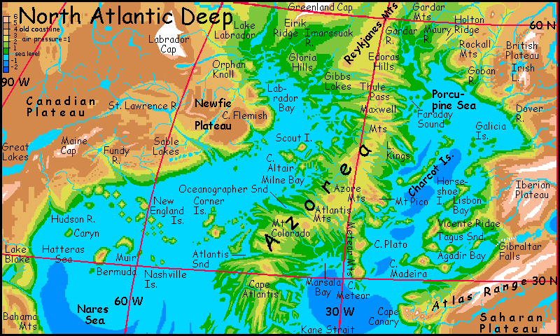
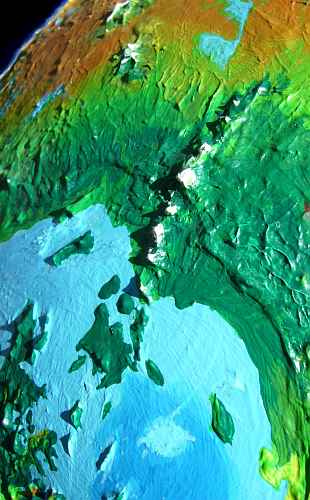
Below is an altitude map of the northern Mid-Atlantic Ridge snaking through the Deep, and below that is an orbital photo. Let's start by taking a trip down this rift zone, now a rugged fjordland swooping nearly pole to pole:
Starting in the north, there's Azorea, a huge peninsula jutting south from the lake-dotted tundra between the icecaps of Greenland and Scandinavia. Azorea runs southeast as far as 23 north. The land is dissected by steep "fjords"--not true ice-carved valleys, but huge cliff-walled fractures where the pressure from crust spreading in a curve shears rocks in long straight gashes looking very much like our fjords, and so the locals call them--or fracts, short for fracture zones.
Must-sees: beautiful, leaf-shaped Kings Lake at 45 N (off the top of the orbital photo, sorry); the central Azore Range, as tall as the Andes in places, culminating in icy Mt Pico, over 6350 m hi (20,800') at top; its strange spur, the Meteor Range, a series of huge cliffwalled mesas like Atlantis, Plato, and Cruiser, cool misty upland forests ending in cliffs and waterfalls, like a temperate Roraima. Cape Meteor thrusts hundreds of km southeast into the sea (top right of photo).
Just above 30° north, the Atlantis Fracture cuts across Azorea, from one "fjord" to another, arrow-straight, forming a cliffwalled pass through the highlands. South of this is the rugged Atlantis Peninsula--a maze the size of France full of straight ridges, valleys, and fjords all sporting kilometer-high cliffs and waterfalls.
At 23 north, one fracture cuts right through--Kane Strait, the northernmost transatlantic passage. Ports along Kane Strait will be both prosperous and very scenic--as long as they last. Huge cliffs, heavy weathering, tectonic slippage creep and quakes all make rockfalls and landslides inevitable. The Strait is deep and unlikely to plug, but tsunamis, trapped between cliff-walls, may scour the shore towns for hundreds of kilometers. However, casualties from such disasters may be lower than you'd think. This is the Atlantic Deep, and the dense air and high oxygen levels have supercharged evolution--much of the population here won't be human. Megaparrots and giant ravens can flee by air given even a few moments' warning, the bonobos and gorillas can climb trees, and the giant Amazonian otters can ride even tsunamis with a good chance of survival. No, it's only the humans who'll really get slaughtered. The Strait will rebuild. There will always be a Port Kane.
South of the Strait lies Kane Island, as big as Borneo (and hotter) running down to 12 north. It's the big island at upper left in the orbital photo). Here the dense air of the Deep nourishes rainforests lusher than our Amazon--and many refugee species from that now-cooler-and-drier upland can be found here. The cliff-walled fjord cutting deep into the eastern flank of the island is a fracture zone not quite as deep as Kane Strait, but still the easiest pass across the island's rugged central mountains. I don't know its name yet; the atlases I've consulted only name the largest, ruggedest fractures.
Notable on the west coast is Researcher Peninsula, a great pitchfork shape of ridges up to 3500 m high (11,500'). A couple of hundred km south is the longest single fracture-ridge I've found, Cape Barracuda. The Barracuda fracture cuts right across southern Kane, carving a low, lake-dotted pass. The island continues hundreds more km to the south before ending in a fracture so deep it creates the first sea-passage in 1600 km (1000 mi): Vema Strait.
Over the strait lie the Vema Islands, bigger than Britain, stretching from 5-12 north (smaller islands, center left). Steambath! The three main islands are huge Doldrums (half as big as Sumatra), Vema (long isle with high ridges: Java?), and Guinea (the little one, only the size of Ireland). The Vemas are even hotter than Kane, and wetter. They're named for the fracture zones creating them. Doldrum, though, is an oxymoron now: the word originally meant a latitude where winds failed, becalming ships. Not any more. Might as well name it Squall. Or Downpour...
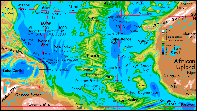
Trees here reach over 100 meters, as tall as redwoods. Ground animals like me would find it impassible, impossible--hot, damp, dark, steep, oppressive. The canopy is the place to be, full of flowers, fruit, breezes, views and light. Who lives here? Fliers and gliders, or arboreals like lowland gorillas and chimps. Old Africa is now too cool for comfort. But the Deeps are ideal for them--better than home! The plentiful food and extra oxygen has allowed the expansion of that energy-guzzling organ called the brain; these cousins of the naked ape have done a lot of catching up. The megaparrots, of course, will tell you "humans are the ones needing to catch up." Never a modest bunch, and less so now that their treetop villages cover all the tropic Deeps.
South over Guinea Strait lies the huge island or minicontinent of Sao Pedro, straddling the equator (bottom center). More of the same: hotter than anywhere on our Earth, wetter, and greener.
Just to the south is the deep cliffwalled slash of Romanche Strait (bottom right on photo). How deep? Miles deep, even now! Old Earth's oceans were deep. Even after the Big Slurp, the sea reaches waist-high on these cliffs.
Every word I said about Kane Strait goes double here--the heat, rain, cliffs, waterfalls, geological instability... and the crazy loveliness of the bird-cities clinging to the crags. And the sleepiness of the otter-dominated ports at their feet. "Lazy otters" seems like an oxymoron, but in this heat and humidity, you'd be lazy too. These towns come to life at night, when it cools to only 30 C (86 F).
NORTHWEST: the Yankee Sea
Down the east coast of Newfoundland Bay:
The gentle Gloria Hills, with a climate like southern France. Vineyards? Why not? But some of the vintners may be giant birds or gliding lemurs. The Deeps are a strange mix of the climatically familiar and the bizarre. Air changes all. Don't believe me? Imagine you grew up in Tibet--a worldwide Tibet. Now tell me you could extrapolate the rainforest of the Amazon from that!
The Gibbs Lakes, and Gibbs Fracture to the east, cutting through the mountains toward Europe like an American highway project gone mad.
The lovely subtropical isles of Maxwell Sound--as big as (and at a latitude similar to) the sounds around our world's Vancouver Island. But the Deeps trap heat; despite the proximity to Greenland, snow here never reaches sea level and rarely even dusts the hills.
Scout Island, a Fuji 4 km high (over 13,000'), snowcapped in winter, but bare briefly in summer; even a volcano this high has no glaciers, not in the Deep.
Cape Altair, a tangle of rugged heads and sounds and islets, like a greener Greece. Again, subtropical; the snows of Mt Altair, at 3640 m (12,000') melt each summer; even in bad winters the snowline never reaches the coast.
Oceanographer Sound, like a cleaver-hack 300 km long--the next big fracture valley.
The Corner Islands, part of a transatlantic flyway for the intelligent parrots and ravens who dominate the tropical part of the Deep. Hilly, but not huge volcanoes like those we've seen to the north.
Atlantis Sound, another fracture-fjord. And not the last. An endless maze of capes and fjords, all the way down to the equator... In our purely human world, each sound would support a different fishing tribe, for overland travel here would be hellish. But the dense air of the Deeps supports much larger fliers and gliders; the north walls of these fjords get sun all day, generating strong local updrafts ideal for such fliers. They'll be dotted with doors and windows of cliff-villages populated by huge, mutant ravens or parrots; perhaps even large, intelligent mammals gliding on skin flaps, like our flying foxes. Their cultures will be unified, not isolated; the washboard terrain we'd find so forbidding is friendly to them.
On the west coast, three miles below the old American shore:
The fjords from Mt Dana to the Flemish Plateau and Cape Newfoundland
Inland, between Greenland's satellite icecapes of Labrador and Maine, nestles the lake-dotted St. Lawrence Plateau, an upland that's almost livable (if you're human), or livable (if you're Finnish).
The long Hatteras coast broken only by the New England Islands, a volcanic chain leading halfway across the Yankee Sea, where the Corner Archipelago takes over. Together they form a transatlantic flyway for winged citizens of the Deeps. The climate here's already subtropical, even though the New Englands are tall enough that (with your Old Earth habits) you expect to see snowcaps. The heights do see snow in bad winters, but banana trees flourish on their shores.
At 29 north, the Blake Plateau, a broad shelf well below the old sea level and well above the new: one of the most Earthlike places on Siphonia, with normal air pressure and flora, fauna and climate like Georgia and Florida. When the air and sea migrated downward, so did they, settling around Lake Blake.
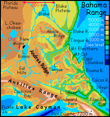
Offshore from the Blake bulge: tall, rugged Bermuda and its lower, gentler twin Muir
the Hatteras and Nares Seas--warm, cloud-dappled, hurricane-prone.
The spectacular Bahama Mts with their canyons and waterfalls 2 km high..
the long Caribbean shore, hot and hurricany beyond anything Terran
long steamy Ceara Island and the Ceara Strait to the south seas.
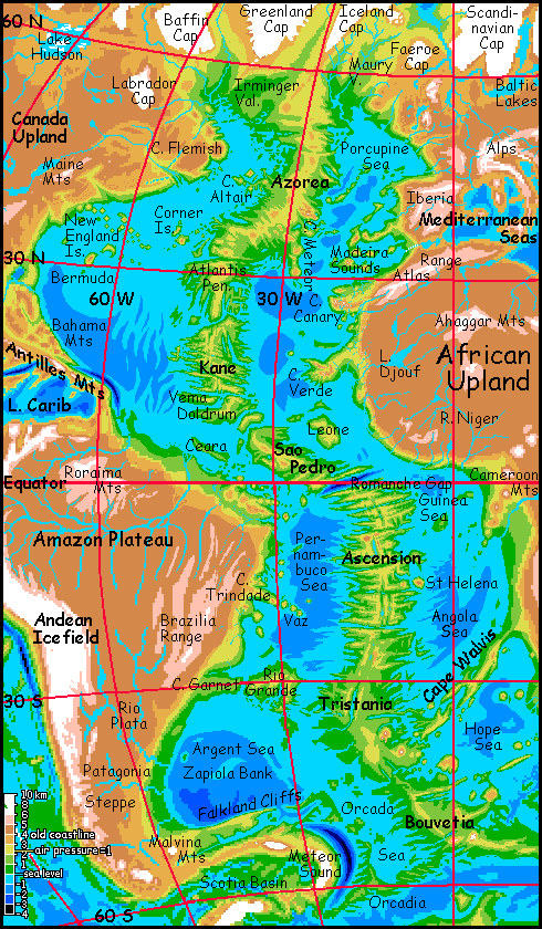
NORTHEAST: The European Seas
In the far north are great cool-temperate valleys running down to the Porcupine Sea: from west to east,
Or maybe Brits will just go on cursing the weather and carrying umbrellas, in the streets of New London on the Maury or Rockall River, a thousand km west and over two km below the poor old Thames, where caribou wade (in the few months when it's not iced over). Either way, bears or barristers (or bears who are barristers, let's not be specist), these valleys will be an interesting land--mild, green and fertile, yet almost within view of the Ice. And not the only place of this sort: consider the new cooler India below the Tibetan icecap, or Amazonia below the great ice wall of the Andes! It's a juxtaposition inconceivable on Earth today--yet twenty thousand years ago there were rich grassy steppes right up to the edges of the ice in many places.
Lowlands at the head of the Porcupine Sea:
Lovely leaf-shaped Kings Lake with its surrounding ridges.
Then the Meteor Range, culminating in icy Pico, 6350 m hi (20,800')--tall than Denali or Kilimanjaro, and the only peak on Azorea to bear glaciers.
Offshore, the New Azores--though I don't know their exact size and arrangement. They're low hills, much warmer and rainer than our old Azores.
Back on the east coast, below the Iberian Plateau:
THE SOUTH
The Southern Riftlands
On the equator: spectacular Romanche Strait, one of the hemisphere's deepest trenches. An astonishing vertical gash, with rugged, waterfall-streaked jungle cliffs. Useful, too: the last passage between the eastern and western Deeps we'll see for some time. For ahead of us lies....
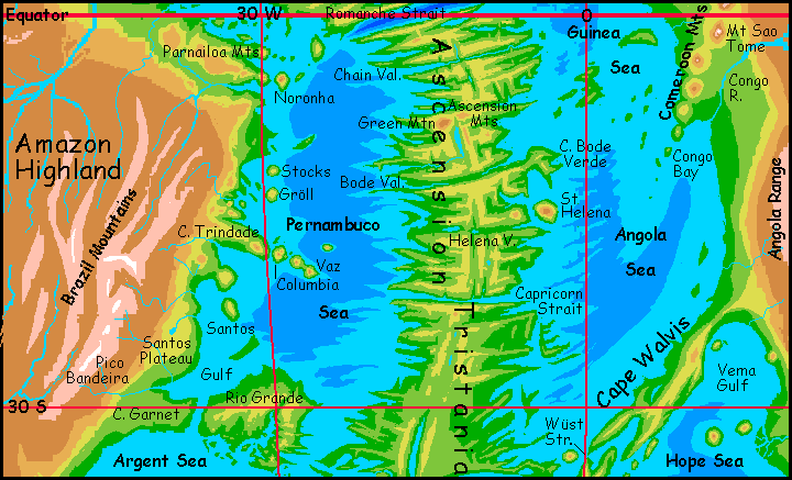
Ascension: from the equator to 23 south. It's bigger than Old Greenland; indeed, the second largest island/continent on Siphonia, after Great Hawaii. All of Ascension's as rugged as Azorea to the north.
Several more great fracture-valleys cut through the continent, at intervals of a few hundred km--Chain Valley, just a few hundred km south of Romanche Strait, then Ascension Gash at the foot of Green Mountain, nearly 5 km high (16,500'). In the Atlantic Deep's dense muggy air, that's still not tall enough for snow--not this close to the equator. It's a strange, broad-shouldered peak, as massive as Kilimanjaro--hundreds of square kilometers of cool, windy plateau, all fern and grass, floating above the clouds.
Then comes Bode Valley, then Helena Cut, named for the volcanic island off its east end: Saint Helena, where Napoleon was exiled is still there, though a bit changed. Today it's a great volcanic mesa three miles high and ten wide (almost 5 km high, 16 wide); a near-perfect twin of Green Mountain, in fact, up to its ankles in shallow sea, waist-deep in the ubiquitous clouds, cool windy plateau floating above them like a ship of grass.
Most of Ascension's spine isn't that high; but high enough to be merely hot and rainy, not an utter steambath. Like our New Guinea uplands, times ten? No, too warm. As warm as our sea-level tropics, even in the highlands.
The ground cover's all lush rainforest except in the far south, where the storms turn seasonal and meadows open up around Capricorn Strait.
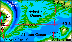
Tristania: 23-60 south! Nearly the size of Australia, but it's not quite a continent: linked to South America via the Orcadia Neck in the southwest, and possibly to Africa by Cape Walvis to the northeast...
Tristania is quite hot in the north and mild in the south. There's some (relatively) dry Californian climate on its west coast--but California with occasional hurricanes. This is still the Atlantic Deep!
It's the southern-hemisphere equivalent of Azorea in the north. Eventually I'll have a more detailed description of this huge, rugged, interesting landscape, but right now I can't do it. My branch library is closed for earthquake reinforcement (in case you're wondering where my obsession with geology and geography comes from, look no further: I live right atop an active fault!), and the really good reference atlases are in storage. The Web just doesn't have any maps detailed enough... Due to global warming, it's too damn hot today to bike miles to the main library...
Orcadia--in our world called the American-Antarctic Ridge. We're far south now, sixty degrees or so, but the climate's still pretty mild--most winters are snowless on the coasts. Dense conifer forests--redwoods?
Near its southwest end, Orcadia may have a strait leading to the African Ocean. If not, a canal is probably diggable; a few dozen km through a valley barely above the new sea level, in a climate far less grueling than Suez or Panama.
THE SOUTHEAST: the Congo Seas
The Guinea Sea--due to increased air pressure these equatorial shores are effectively 2 km below/hotter than our equatorial rainforest. Welcome to the Carboniferous! Constant rains and 100% humidity, blood-warm water, hundred-meter trees. It's great country if you're winged and live in the jungle canopy, but no fun in the gloom beneath, unless you're mold. Mold is happy.
The Angola Sea is one of the biggest unbroken sheets of water left on Siphonia, rivaling the Mornington or Davis Seas. Another steambath, it generates hurricanes on a regular basis all summer; even in winter the storms merely shrink and allow some sun between barrages.
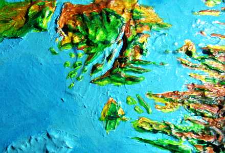
In the orbital photo to the right, that great chain of volcanoes is the Cameroon Range. The Cameroons create a peninsula jabbing southwest into the Angola Sea. These peaks are up to 8 km tall (26,000')--Mts Cameroon, Bioko and Sao Tome are even snowcapped, even on the equator. Some rise from the African Upland (the old continent, now a high, cool plateau) but some of these snowcones rise from the Deep itself--one of the hottest jungles on Siphonia! That'll make for some weird weather...
Rugged Cape Walvis is the long trail of another volcanic "hot spot" like the one that created the Cameroons. But the lava flows hare have built up a relatively continuous mountain wall jutting southwest from Africa. There's one possible gap--narrow Wüst Strait. If it exists! It's right at the postulated sea level, and quite narrow. I'm inclined to think the copious rains of the Atlantic Deep will cause it to spill over this low sill, even if no channel exists. And if not, some enterprising species will dig a canal. It wouldn't be hard; low ground and soft sediment.
Does it matter? Oh, yes. Having such straits would link the Atlantic and African Oceans into by far the largest surviving ocean in the world, allowing sea-trade from Somalia to Labrador. It'd have huge cultural effects. The Pacific Basin would have a shipping disadvantage that'd almost certainly translate into slower cultural development.
Where does the Atlantic end, then, and where does the African Ocean begin? Originally I thought the ridges along the south shore of the Hope Sea were continuous, so it was the last basin of the Atlantic, linked to it by Wüst Strait; but now I believe these southern heights are broken, just a flotilla of long islands like Schmidt-Ott, volcanic chains like Wyandot, and huge mesas like Discovery and Meteor, all with broad shallow straits into to the African Ocean, the largest surviving fragment of the Indian Ocean--and larger still, if Hope's an integral part of it.
Since the bathymetric maps I've consulted disagree so much on the Hope Sea's borders, I'm holding back on describing it in too much detail yet. For now, I've put a tentative close-up map and a catalog of its known features on the African Ocean page. But further bathymetry could force me to move it right back. Scuttling seas!
SOUTHWEST: Pernambuco, Argent and Orcada Seas
The Pernambuco Sea. A sauna. Rain measured in meters and daytime temperatures averaging over 40 C (104 F). Worse yet, the dense damp air means it doesn't cool off much at night. Very few humans live here, in the heat and damp and gloom. Intelligent life abounds, though, in the treetops: giant parrots, otters, and bonobos, chimps and gorillas, all lanky, long-limbed, slender and short-haired for heat dispersal.
South of Cape Santos it's a bit less muggy, especially on huge Rio Grande Island, nearly as big as Madagascar. Its hills are not much hotter than our equatorial zone.
I apologize for the orbital photo, which suffers from blur and glare, and clips the north short of the island, but it's all I've got. At least it shows you we're well out of the equatorial rainbelt now! And you can see Bromley Sound, that long curving wedge of sea cutting into its south shore. This will be a scenic region--its shores and islands rise dramatically from the sea in red cliffs and scarps. Southern Italy, Greece?
This shore of Tristania is equally impressive--a maze of long cliffwalled "fjords" with Mediterranean climates. Not terribly fertile, but pretty. The Bromley Cliffs and Tristania's fjord-walls are ideal habitat for gliderwolves. These cliff-dwelling canines are smaller and lighter than our wolves--more like small dogs and skin flaps down their sides. Oh, and big brains. And clumsy but somewhat opposable thumbs. Gliderwolves farm the floors of these valleys and dig whole cave-villages into north-facing cliffs, where the sun-heated rock generates updrafts all day. Anasazi pueblos as dreamed by Coyote...
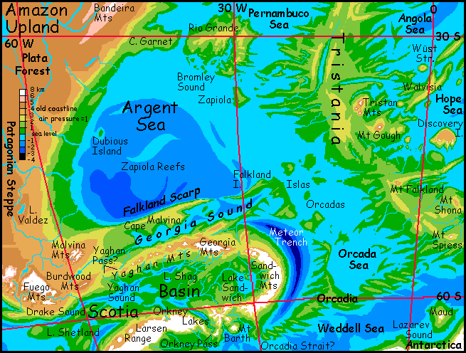
The Argent Sea and tilde-shaped Zapiola Bank--vast coral reefs! Yes, coral past 50 south; the higher air pressure retains that much heat! It's Mediterranean even here.
The Falkland Escarpment--a spectacular line of cliffs from 1.5 to 2.5 km high (5-8000') rising from the southern end of the Atlantic. The plateau above them is mostly alpine meadows but there are some conifer woods. Harsh winters with deep snow, but no glaciers. Really, it's surprisingly mild for an upland so far south--that high air pressure again. It's much what the old Malvinas/Falklands were. Any Scot or Dane would find the climate bracingly familiar.
The gap into Georgia Sound is like a scaled-up version of Alaska's Inland Passage--cool, dark, dense forests below icy peaks up to 6 km (20,000') above the new sea level. Raven country. The combination of cool temperatures and dense air makes it ideal for them. Rather than clear the forest they just nest in it--burn multileveled houses inside the trunks of huge trees.
The Islas Orcadas--a thousand-mile scatter of low, cool, heavily forested islands. The largest, Falkland, is a jagged dragon 800 km long (500 mi).
The Sandwich Coast--much more rugged, with icecapped Andean peaks above mild temperate shores. Aside from dense air, it's quite Earthlike here; expect lots of human refugees from the uplands to settle here. But then, intelligent ravens with 3-meter wingspans are just as common. The bars are full of them. Ravens have big egos--they love to impress. So expect a lot of music nights with prizes for original songs--though the real prize is your choice of mates. With those raspy, complex voices, ravens are into Tuvan throat-singing. Yes, ravens sing harmony with themselves. Not pretty, but... interesting. The audio equivalent of smoky scotch. The lyrics, of course, are all black humor. Sad, earnest folksongs won't get you laid in ravenland. Cynics rule.
Unless Amazonian otters crash the show. Relentlessly cheerful! Otter sailors aren't teary drunks. You want a clash of civilizations? I'll give you a clash of... ahem. Sorry. Where was I? Oh. Those otter-sailors. There was a reason they staggered into that club: they're all over the south. That's where the work is. This may be the world's busiest shipping lane. Here's why:
South of Meteor Sound and the Orcada Sea stretches an ambiguous strip of land 2000 km long. Orcadia's low, convoluted, a land of dense conifer forests--British Columbia with milder winters. But is this strip a peninsula or an isthmus? Orcadia's west end, on Meteor Sound, may have a narrow strait south into the African Ocean, the largest remnant of our Indian Ocean. The bathymetry here is borderline. It's either a narrow strait or a very low valley. If a valley, a canal would certainly be diggable. It'd link half the scattered seas of Siphonia, with all that implies for shipping... including the building of a great port city here, Meteora. With a very diverse music (and singles) scene...
But the Meteor Canal's less likely if the Wüst Strait exists to the northeast--or if there isn't, but the easterners dig the Wüst Canal first. If so, no otters crash the bar; the ravens, uninterrupted, sing their cynical blues.
|
|
Siphonia's homepage - map - peoples of Siphonia - Siphonia's evolution - Gazetteer
LISTS AND LINKS: More worlds? Planetocopia! - dreams of other worlds - ecology - climate change - evolution - natural disasters - terraforming - sculptures and 3D art -
World Dream Bank homepage - Art gallery - New stuff - Introductory sampler, best dreams, best art - On dreamwork - Books
Indexes: Subject - Author - Date - Names - Places - Art media/styles
Titles: A - B - C - D - E - F - G - H - IJ - KL - M - NO - PQ - R - Sa-Sk - Sl-Sz - T - UV - WXYZ
Email: wdreamb@yahoo.com - Catalog of art, books, CDs - Behind the Curtain: FAQs, bio, site map - Kindred sites