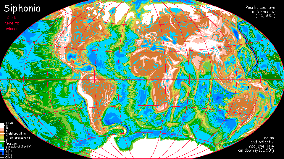
Siphonia:
BENGAL SEA
by Chris Wayan, 2006-9
Siphonia - map - regional tours - People, Creatures - Evolution - (don't click yet: Gazetteer - Glossary) - more worlds? Planetocopia!
BENGAL BASIN: OVERVIEW
This mid-sized, tropical sea basin is hotter and wetter than anywhere in Earth's equatorial zone. Air pressure at sea level is 1.6 atmospheres, retaining heat and moisture and upping the maximum practical flight-weight. Many midsized mammals glide, and gigantic birds abound, some intelligent.
It isn't clear yet if the Bengal is a stranded sea, or the easternmost lobe of the African Ocean. See notes on The Port of Egeria below.
Sorry, no detailed tour yet! Just notes on regions and local features... I'll start in the north and sweep south... or at the high point and drift downstream. In the Bengal Basin, they're the exact same thing. One of the most consistent altitude gradients of any region of Siphonia. So...
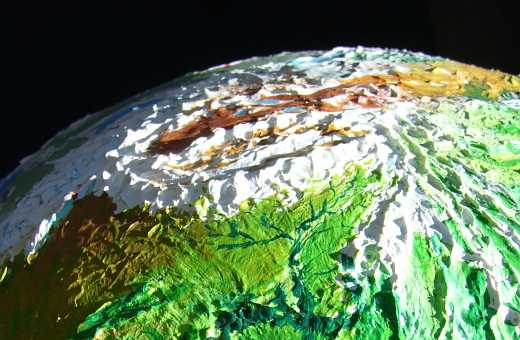
THE TIBETAN ICEFIELD
TIBET is now a great ice cap, a frozen sheet the size of Greenland, though the ice is much thinner. The rock of the Tibetan plateau is so high that few storms can reach it, like Antarctica's interior. Though rocks and peaks and ridges break through the ice everywhere, all of Tibet is permafrost, even though parts are only 30 degrees north. Why so cold? Now that the seas have dropped, the air's as thin as Earth's at about 7000 meters--over 23,000'.
And that's just the average; dozens of peaks effectively rise out of the atmosphere now. Mars on Earth! Mt Everest is nearly 13 km high: 43,000'. The Silk Road and the traditional north-south passes are now useless--not just glacier-choked but unbreathably high.
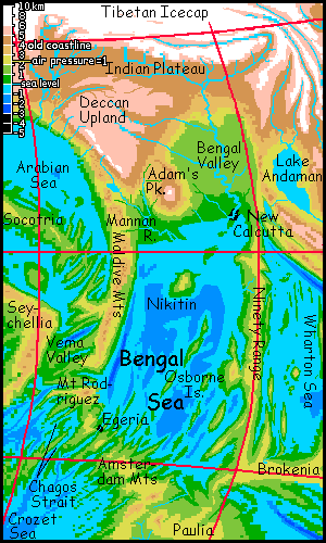
INDIAN UPLAND
To the south of the alpine slopes of the Himalaya are the mild upland forests of the Ganges and Indus Valleys. The climate's like that of Himalayan hill stations today--warm summers, cool winters, rich soil replenished by glacial silt from Tibet. The rivers and lakes are all eerie turquoise from that fine-ground rockflour.
Further south are the grasslands and scattered woods of the Deccan Plateau. A bit higher, cooler and less fertile than the Ganges Valley, but much more fertile than today--more reliable rains. And a lot cooler! The Western Ghats are now snowy in winter, and even the Easterns can have snow flurries. The new India is more like old Europe. Which is handy, now that Europe's all tundra and ice...
THE BENGAL VALLEY
To the southeast, the sweltering rainforests of the Bengal Valley cover more than a million square km (400,000 sq mi). The upper reaches, not far below our Bangladesh, may be suitable for humans; but the lower valley is emphatically not. Here, ground level is a stifling, dripping, gloomy maze of mangrove buttresses.
No matter! Megaparrots do just fine--weaving treetop villages, cultivating fruit and nut trees--plus a lot of parasitic fruiting vines using those trees for support. Much faster to breed than trees living centuries. You just have to be careful not to get too productive. Farming is always subject to crashes due to overproduction, but in the Bengal Jungle these crashes aren't economic--if you overburden your trees, you crash your whole village!
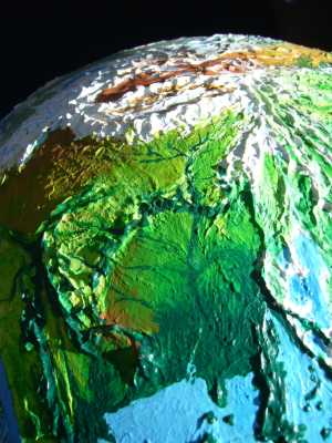
The greatest city in the Basin is New Calcutta, on the Bengal River Delta. In this steamy swamp, semiaquatic otters and treetop parrots have built a strange two-tier port. This biraciality is less cosmopolitan than Egeria to the south (whose species-mix includes several cooler-zone peoples, like humans and giant ravens) but it's still a fascinating town. Except for three hours after noon. Siesta city! Everything shuts down. Too damn hot.
To the southwest: the snows of Adam's Peak, 6300 m (21,000') high, crowning the Sri Lanka Mountains. Concentric eco-rings surround its glaciers: alpine desert, fern-fells, cloud forest... The west slope is drier, with open woods and meadows--the upper Mannan Valley resembles our India, with a heavily human population. Indians who didn't stay put and adapt to the cooler climate in the Ganges Plain migrated here (as well as the upper Bengal Basin, not far south of Old Calcutta).
AROUND THE BENGAL SEA...
Off the Bengal Delta, ranging southwest... the rugged Nikitin Islands. Sweltering rainforests. Parrot villages, with giant otters fishing the coasts, much like New Calcutta.
To the south are the Osborne Islands--long rocky ridges heaving from the sea like frozen red stormwaves. Still very hot, but drier; in a high-pressure zone with fewer storms and a long dry season. Open forest and savanna, with bare cliffs in spots. Quite African, except for the dense air and resulting megafliers and gliders. Some humans live here, a tall slender heat-adapted breed; but most of the people here are still avian or otters.
The Bengal Sea is bracketed east and west by odd, twin isthmi: Chagosia to the west and Ninety to the east. Lower than the Sri Lanka Range, these twin necks of cooler land between and above the steamy lowlands are a bit like old Ceylon's hills; mild forested plateaus. Tea does well in the heights. Warmer than the Ganges Plateau, but these sky islands resemble the former India more than the hot, soggy basins around them.
In the east, the Ninety Mts cast a weak rainshadow on the east shore of Bengal: this coast has rainforest instead of downpourforest. Only half the hurricanes!
But in the west, on the Chagosian shore, storm after storm hits the slopes of the Maldive, Chagos and Rodrigues Mountains, endlessly drenching the forest-slopes. You have to be semi-aquatic to live here. Most of the people are giant Amazonian otters. Even megaparrots get sick of the rain...
In the far east, over the Ninety Mountains, is the old Andaman Sea. It's now a huge freshwater lake a mile up. It still probably drains into the Bengal Sea through a gap in the Nineties, but it's just one of many such high-altitude Javan Lakes and Seas and so is described on that page.
THE PORT OF EGERIA
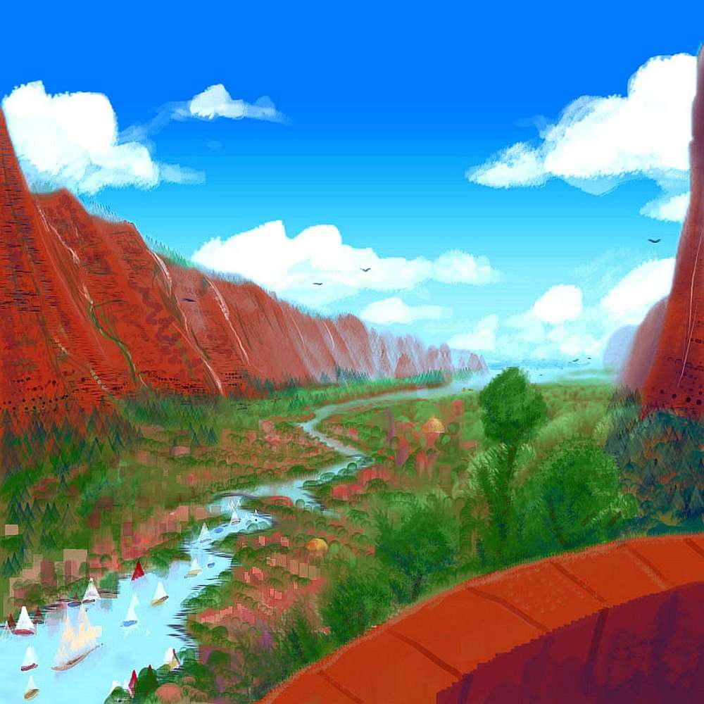
Bengal's spectacular south coast is a complex of red cliffwalled desert "fjords" where transverse cracks cut deep into the Amsterdam Range. It's not a true desert; winter rains are light but reasonably regular; it's just that evaporation's high in the hot dry season. Trees huddle along watercourses and in shaded canyons. Much of the bare rock's just cliffs and landslide-scars. This is jagged, tectonically active country--fracture zones flanking a rift.
Egeria Valley, the deepest of those fjords, is either...

In the "get it right" spirit, I should note that more recent bathymetric maps show that the two fracture zones with the deepest channels--the most likely places for this port/canal city--are really southeast of Egeria Fracture Zone, around 28°S & 73-74°E--that's past the next zone, Flinders, and several unnamed fractures, nearer the Dutch-named cluster (Ter Tholen, Zeewolf and Nieuw Amstardam Fracture Zones) near Amsterdam Island. But neither of the two prime canal canyons are even named yet (as I write, at least, in 2019). That won't last--they're about the last fracture zones on Earth without names.
So call our port town Flinders, Tholen or Zeewolf if you want. No matter what we call it, we'll still be wrong. Eventually.
|
|
Siphonia's homepage - map - peoples of Siphonia - Siphonia's evolution - Gazetteer
LISTS AND LINKS: More worlds? Planetocopia! - dreams of other worlds - ecology - climate change - evolution - natural disasters - terraforming - sculptures and 3D art -
World Dream Bank homepage - Art gallery - New stuff - Introductory sampler, best dreams, best art - On dreamwork - Books
Indexes: Subject - Author - Date - Names - Places - Art media/styles
Titles: A - B - C - D - E - F - G - H - IJ - KL - M - NO - PQ - R - Sa-Sk - Sl-Sz - T - UV - WXYZ
Email: wdreamb@yahoo.com - Catalog of art, books, CDs - Behind the Curtain: FAQs, bio, site map - Kindred sites