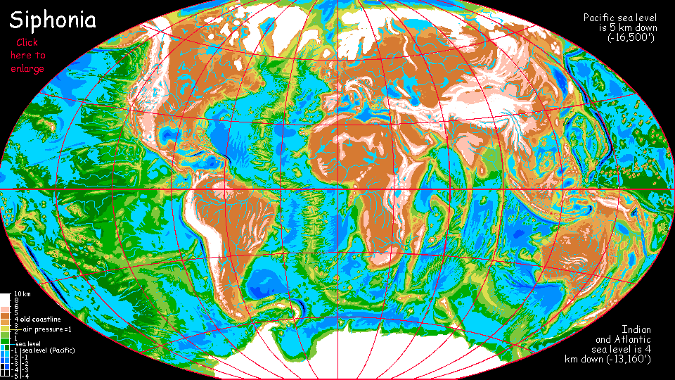
Siphonia:
Javan Seas
by Chris Wayan, 2006-9
Siphonia - map - regional tours - People, Creatures - Evolution - (don't click yet: Gazetteer - Glossary) - more worlds? Planetocopia!
Introduction
Southeast Asia and its attendant islands are complex enough in our world--a tectonic pile-up where plates squeeze and shatter--but on Siphonia, the receding seas have bared an unbelievable tangle of Himalayan ridges and deep lake-basins. It looks more like a chunk of Venus than Earth.
The region's heart is the Malaysian Plateau. But around this level highland half the size of Australia are snaky ridges and valleys, lakes and mountains. As the Indian Ocean tectonic plate slams into Southeast Asia in a slow fender-bender, the collision's built Himalayan-size ranges and then twisted them under the strain. Much of that's hidden in our world; but Siphonia exposes it.
The only generality I can make is that most of it's high up and cooler than on Earth; as air pressure dropped, the curving ridges typical of this crushed landscape trapped big lakes and seas. In other regions the sea level dropped so far that air pressure actually went up, trapping heat; not so in Southeast Asia. The shores of these high-altitude lakes are no warmer than they were as Terran islands, and generally cooler. Snow in Borneo, Java, the Philippines? Yes.
But "cooler" is a deceptive generalization; climates here are emphatically local. It's a three-tiered world: cool tropical uplands, warm tropical lake-basins much like Indonesia today, and sweltering typhoon coasts the dinosaurs would have loved.
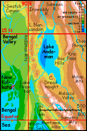
Malaysian Plateau
In our world, this plateau is a warm shallow sea between Vietnam, Malaysia and Indonesia; the coasts are rainforested (where they're not plantations or ricefields). But in our last Ice Age, this seabed was a vast plain, wooded and rainy on the coast, but brushy inland. The Siphonian version is in between: a cool wooded upland, still fairly rainy even in this drier world. The plateau's 4 km above the new sea level (climatically about 2 km or 7200' up), dotted with lakes and small seas around the periphery. Its heart, though, is a pretty featureless plain bounded by the snowy mountains of Malaya, Borneo, Sumatra and Java.
The climate's a perpetual spring. We have few comparable highlands--certainly not the Altiplano! Ethiopia perhaps. On Siphonia these tropical uplands are extensive, prosperous farmlands, densely settled--but not by the new flying species of the Deeps. This may be former sea floor, but the air's too thin for them to get off the ground easily.
Who lives here, if not them? Well, humans are still around; farming the ground level. Orangutans tend orchards; giant Amazonian otters have fishing villages along the Mekong and Chao Phraya. Elephant contractors do most of the construction work, of course. But even a four-species civilization seems tame after visiting a true oceanic Deep.
The Java/Sumatra Mts and Wharton Coast
The Sumatran and Javan Ranges along the southwest rim of the great plateau are a long chain of volcanic cones as high as 7600 m (25,000'). The south slope is stormy; the dense air at the mountains' feet traps heat, and summer is a brutal succession of typhoons off the Wharton Sea. The peaks are so high that the storms become blizzards and hailstorms (on the equator!): while most snow soon melts, icefields mantle the volcanoes; their flanks are an amazing sequence of microclimates, from alpine meadows through cool rhododendron forest to mild uplands with springlike year-round temperatures to muggy rainforest at their feet.
Does old Indonesia survive at all? Oh yes. The Sumatran mountains don't rise straight from the sea; there's a coastal range called the Mentawai Hills. The long valley between the Mentawais and the great volcanoes to the northeast is about 2 km above the new sea level, just right for temperatures comparable to Bali today. The worst fury of the Wharton Sea's hurricanes break on the seaward slopes of the Mentawais, leaving this great valley merely hot and rainy. Quite Javan, really.
Lake Andaman
In the northwest, the lower (but still occasionally snowy) Malay Range splits the great plateau into the Thai Valley (a cool-subtropical upland below snowy mountains, sort of a new Szechuan now that Szechuan's unfarmable...) and the long Malacca Valley leading west and down to Lake Andaman, as big as our Caspian Sea. The lake, aside from lower salinity (in fact quite fresh now, since it drains into the Australian Ocean) and sea level (about 1.5 km (5000') below its former shoreline) is surprisingly unchanged from our Andaman Sea. In a world where nearly every climate's changed, Andaman is still a warm, rainy basin--tropical, but fundamentally Terran; it's a refuge for the species of old Earth's Indonesia like the Mentawai Valley, for it's spared the unearthly heat of the lower Nicobar River and the Wharton Coast and the cold of the new highlands. But then, it can't sustain the fascinating fliers and gliders of the Deeps, either.
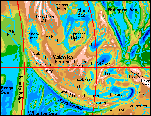
China Sea
To the northeast, the Plateau ends in another great range, the Borneo Mts, culminating in Mt Kinabalu, 8140 m high (26,700'), highest in the region. Its icefields are visible even from the shores of Palawan Sound 150 km away--and 6650 m lower (22,000').
Due north, the Plateau slopes gradually 2 km down to the China Sea. Not the East China Sea or the South China Sea; just the China Sea. The shallow northern sea separating Taiwan and Korea from China is now a cool, forested plateau reminiscent of New England or Canada.
What we know as the South China Sea has shrunk to about half-size; what survives is mostly the north. The south is a maze of low, jungly sounds below mild, wooded plateaus--the former Paracel and Spratly Islands.
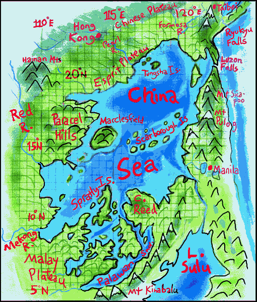
When the oceans drained away the China Sea was left stranded in its high basin like a monster tidepool. Half its water poured out the Bataan Strait. The sea level dropped 2500 meters (8000'). As the atmosphere pooled in the new abysses worldwide, temperature, air pressure and climate migrated downward almost as far, about 2200 m (7000'). Since its altitude drop is one of the few in the world that nearly matched this worldwide average, the China Sea shores have changed the least of any region on Siphonia.
Fauna and flora look quite Philippine--green and lush. The coast is just as warm, though the hills and mesas of the Paracel and Spratly Islands and Cape Reed, two km high, are cool misty uplands like our Roraima--but then the Philippines had its cool uplands, though not as extensive. Even the geography looks similar; a confusing maze of steep islands and winding sounds. Unchanged...
Unless you taste the water. Go ahead. It's fresh, isn't it? Rains here are generous, if not quite as torrential as on Earth; so this "sea" overflows east into the Philippine Sea, over a sill between Luzon and Taiwan. A freshwater river white with rapids, not a salt cascade like the famous Mediterranean Spill on Earth three million years ago. The China Sea is now really a huge freshwater lake! Well, mostly. Precipitation has freshened the surface layers and the southern sounds, but the cold depths of the deep northern basin are still brackish.
The other change: the ex-Philippines themselves are less Philippine than they were. The mountains of old Luzon now rise over 5 km (about 17,000') above China Sea level; quite high enough for extensive snow. The Borneo and Palawan Ranges to the south and the Taiwan Mts to the north both rise 6.5 km (4 mi). Great glaciers crawl down Jade Peak and Kinabalu, above forests where orangutans hide. They haven't changed, at least--they're still shy.
Well, it's true they're literate now. The great upland woods around you are their farms.
These cool highlands, ringed by snowcapped peaks, extend far southeast. Lake Sulu, in the heart of the Philippine Range, is at least 1000 m above the China Sea, and 4 km above the Pacific (13,000' up). It drains northwest into the China Sea. It too is fresh on the surface but probably still brackish down deep. And its deeps are so deep, its volume of water so great, it'll take a few Ice Ages to fully flush it out. Its shores are much cooler than the China Sea; almost temperate-feeling, though snow-free.
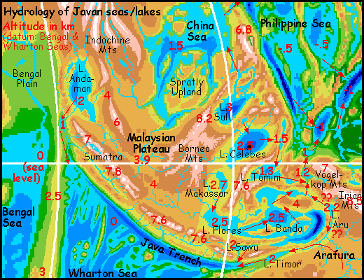
Lake Celebes just south of Sulu is even larger and deeper, though not quite as high; around 2.5 km above the Wharton Sea. Celebes rivals the Sea of Japan as the deepest surviving body of water in the world, up to 3 km (10,000'); unlike Sulu, it drains east through a serpentine chain of huge lower lakes like the world's biggest fish ladder, down to the Pacific: Lake Sangihe, 1.5 km up, huge Lake Tomini, 1.3, then little Obi, 1250 meters, and Halmahera, 1200, tropical below the snowy crags of the Vogelkop Mts; last is steamy Ayu, less than 1000 meters above the Wharton Sea level.
But that particular sea level doesn't mean much to the Ayu River. It drops almost twice that (over a vertical mile) to Palau Sound, the westernmost finger of the Pacific! For that ocean lies a kilometer below the level of the Bengal and Wharton Seas. It's a wild cascade, that final drop--a Niagara, then a Victoria Falls, then an Iguazú, then a replay of all three, down through a misty jungle canyon as hot and humid as a time-trip to the Mesozoic. Even upwind of the mist from the falls, the sky is bleached near-white by sheer volume of atmosphere. Emerald hills, white water, white sky. Red and yellow flash by in the wings of a giant parrot riding the updrafts to her orchards (4-meter wingspan; brain smarter than yours. Voice much, much louder than yours, too, as you'll find to your regret if you stop to ask directions. Parrots are enthusiastic.)
For more on this peculiar pastel world, see the Pacific Deep. But it's forty in the shade (104 F), and 100% humidity here by Ayu Falls. Can we go back upstream now?
Sunda Seas
South of the Celebes Lakes lies an equally complex region with great lakes/small seas at various altitudes, whose shores range from steamy to cool. The highest peaks, in the Sulawesi and Vogelkop Ranges, rival those of Java.
The hydrology of this region is to some extent still uncertain; the map above has arrows showing the most likely drainages, but I may have to revise this extensively, as I discover more about the altitudes of sills between basins. Fifty meters could make the difference between a Flores Sea that drains north to Ayu Falls, as I've shown it, or east into Lake Aru and south to Lake Timor and eventually the Wharton Sea, or southwest to Wharton more directly, through Lake Savu. Here's a map without arrows, just showing the topography.
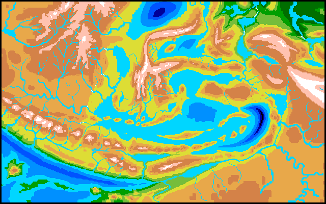
The Barito Valley or Java Plain: much the same; these fertile uplands with moderate rainfall will be heavily populated, though not by Deep species.
The valley ends abruptly in the Wallace Escarpment. It's as much of an ecological boundary on Siphonia as it was on Earth, though for different reasons. To the west of this mile-high scarp lie the cool plateaus of the Malay uplands; to the east, the much warmer--quite Indonesian--basin of the Flores Sea.
Even those with no interest in the power of temperature and air pressure to erect barriers as effective as moats, in this world full of fliers and gliders and land-bridges, should still venture to the brink of Wallace Scarp. Barito Falls should not be missed.
Beyond the white mist-banners at the foot of the falls lies a tropical coast. Flores Sea, 1600 km long (1000 mi)--the size of our Black Sea. Its east end hides Weber Trench, nearly four miles deep (and a rival for deepest point on Earth; though I think even the half-drained Mariana Trench will win by a hair.) Weber may be brackish and stagnant, far below the new freshwater layers. I'm not sure. The region's rainy, but that's a lot of deep brine to flush out in a mere 90,000 years.
As I said, I'm unsure if Ceram Bay is truly the outlet of the great lake/sea--is its sill really lower than the Aru and Sawu sills? But let's assume so; the immense flow of the Flores then feeds the cascades of Ayu Canyon.
The Lake Sawu basin to the south, 2 km above the Wharton Sea, has a mild wet climate, with flora and fauna much like old Java or Bali, though the snowcapped mountains reach much higher. As with the China Sea Basin, humans here will coexist with gracile elephants and Amazonian otters, with a few eccentric avians from the Wharton.
In the southeast corner of the map is another great plateau, the former Arafura Sea and Gulf of Carpinteria, now an upland called Arafura, where millions of Papuans settled after the air-pressure drop froze their New Guinea highlands. Arafura has much the same climate as the old Papuan highlands, and is far bigger; densely populated farm country. But that's another tour.
|
|
Siphonia's homepage - map - peoples of Siphonia - Siphonia's evolution - Gazetteer
LISTS AND LINKS: More worlds? Planetocopia! - dreams of other worlds - ecology - climate change - evolution - natural disasters - terraforming - sculptures and 3D art -
World Dream Bank homepage - Art gallery - New stuff - Introductory sampler, best dreams, best art - On dreamwork - Books
Indexes: Subject - Author - Date - Names - Places - Art media/styles
Titles: A - B - C - D - E - F - G - H - IJ - KL - M - NO - PQ - R - Sa-Sk - Sl-Sz - T - UV - WXYZ
Email: wdreamb@yahoo.com - Catalog of art, books, CDs - Behind the Curtain: FAQs, bio, site map - Kindred sites