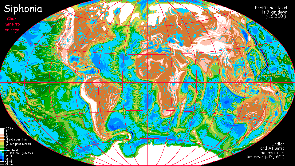
Siphonia:
Mississippi Plateau
by Chris Wayan, 2007
Siphonia - map - regional tours - People, Creatures - Evolution - (don't click yet: Gazetteer - Glossary) - more worlds? Planetocopia!
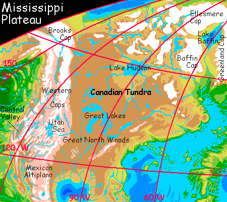
CANADA
Brr. Uninhabited except for hunters and miners. North of the Great Lakes the land is treeless meadow, bog, rock and tundra. Quite a bit more of it may be glaciated than I've shown; I was conservative. Certainly all the hills are ice-capped now; to what extent these caps have fused and spread over the plains is uncertain. However large the icecap(s) grow, they won't be as thick as in our Ice Age; the air's so thin they'll top out around a kilometer thick at most, perhaps less. With less pressure on its foot, and no slope to speak of, the ice may spread slowly if at all; and precipitation will have to climb a long way up the continental shelf to add to it. However, if you want to picture most of Canada under ice, you can. It sure wouldn't be much of a loss.
On the day of the Big Slurp, most of Baffin Bay drained out through Davis Strait to the south. But the Strait isn't that deep, and so a large lake survived. Freshwater today, Lake Baffin lies about 1.5 km down (a mile down); at that altitude, it's as cold as it ever was, but given how the surrounding lands and seas have grown catastrophically colder still, it's something of an oasis for Arctic life. Greenland's fjords are entirely iced-over though, as is Baffin Island.
Hudson Bay shrank much more. It's a freshwater arctic lake now, about the size of our Great Lakes combined. It's only one or two hundred meters below the old sea level, so it's brutally cold, thawing only a couple of months a year. In a good year. Or perhaps never. Certainly most of the lakes, sounds and islands further north have iced over permanently. I've shown some ice-free valleys, like the Northwest Passage, but don't be fooled; they're not much friendlier than Antarctica's Dry Valleys.
THE WESTERN CANYONS
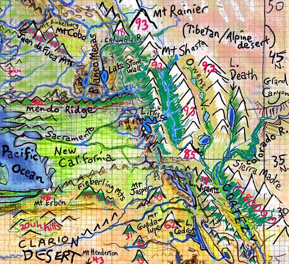
Much of the mountainous west, from Alaska to Mexico, is glaciated again--at least the front ranges of the Rockies and most of the Cascades are. But it's a nuanced story--the region's so rugged that many gaps exist, especially in the south. The biggest and most fertile is perhaps the Central Valley of California, now a great temperate forested basin with snowy winters reminiscent of Germany.
But it's not alone. Oregon's similar Willamette Valley is colder, with longer winters, but it's still wooded and fertile. And there are small surprises. Consider low deserts like Death Valley--on Earth, a searing trench below sea level. Now it's a cool, lake-filled grassy valley below the spectacular glaciated horns of the Panamint Range, 3400 meters straight up... Or the Grand Canyon, now snowy to the bottom in winter and getting more overall precipitation than it did in its Earthly days--every side gallery has living streams and falls down to its subalpine meadows and groves. The North Rim is icecapped, the south, alpine barrens; but the canyon between, cool but livable, is a refuge for hundreds of species. Further south, in northern Mexico, Copper Canyon is much the same.
One "low desert" you might overlook is the former Gulf of California, or Sea of Cortez. Now it's a rift-valley 1000 miles long--Death Valley's just its little finger. As the floor descends, the subalpine meadows and cool forests give way to open woods, prairie and high desert--chaparral and piñon. Lower still, Joshua trees have found a new home... The Colorado River floodplain and its many side branches are well-settled with refugees from the former Southwest, who grow maize, chilis, beans and squash in the rich soil of the riverbends... as they have for 100,000 years. Classic recipes travel well.
Also off the Upland proper, but well worth a visit for any tourist, are the series of canyons and scarps created by the San Andreas Fault and its spurs. There's Monterey Canyon, short but fully 3 km deep (2 miles). Further south, the subalpine Los Angeles Lakes below the Channel Mountains; they drain south into Lake Vicente. The east shore of Vicente and still larger Lake Cedros to the south are scarps and sheer cliffs up to a kilometer high. Snowfed waterfalls fray into mist before they reach the lake... It's reminiscent of old Yosemite, now a near-treeless alpine canyon snowed in most of the year.
LIFE ON THE MISSISSIPPI
Bring a coat. The northern part of the Mississippi Valley is nearly as miserable as Canada. Only the lower stretch of the great river, south of the Ozarks, is really habitable. The climate's much like our Montana. Sparsely settled, I think, with wheat farmers; but then the northern European plain sustains a heavy population in a climate I find just as harsh. Of course, I'm Californian.
Florida and much of the Southeast is milder and damper--cool, misty, with harsh snowy winters. Basically it's New England, though only thirty north! Still, despite its winters, many humans may have relocated here; you do at least see the sun. The muggy shore of the new Atlantic to the east faces constant storms.
THE MEXICAN ALTIPLANO
Climatically, Mexico's heartland is much like our Bolivia. The weather changes in an instant, hot when the sun's out, cold the moment a cloud passes. The air now is very thin, equivalent to 4 km up on our world (13,000')--hard for non-locals to breathe. Most of them are humans who farm the river valleys and lakeshores. They must irrigate, for few Caribbean storms make it over the mountains to drop their snow on heavily glaciated peaks now Andean in height. But as in our Andes, that ice guarantees a steady supply of snowmelt. It's an austere, unworldly-feeling place. Scenic, but with its dangers: many of these ice-mantled cones are merely dormant, and should any of them warm up (let alone truly erupt) they'll send great mudflows down to the plateau, burying square miles of villages. The great peaks bring both life and death.
|
|
top - peoples of Siphonia - Siphonia's evolution - Gazetteer
LISTS AND LINKS: More worlds? Planetocopia! - dreams of other worlds - ecology - climate change - evolution - natural disasters - terraforming - sculptures and 3D art -
World Dream Bank homepage - Art gallery - New stuff - Introductory sampler, best dreams, best art - On dreamwork - Books
Indexes: Subject - Author - Date - Names - Places - Art media/styles
Titles: A - B - C - D - E - F - G - H - IJ - KL - M - NO - PQ - R - Sa-Sk - Sl-Sz - T - UV - WXYZ
Email: wdreamb@yahoo.com - Catalog of art, books, CDs - Behind the Curtain: FAQs, bio, site map - Kindred sites