World Dream Bank
home -
add a dream -
newest -
art gallery -
sampler -
dreams by
title,
subject,
author,
date,
places,
names
GAZETTEER OF THARN
INDEX OF PLACE NAMES
by Chris Wayan, 2005-6
Map, Tharn's homepage, Peoples of Tharn, Regional tours, Geology and Evolution, gazetteer, terms explained. More worlds? Planetocopia!
Jump to A - B - C - D - E - F - G - H - I - J - K - L - M - N - O - P - R - S - T - U - V - W - Y - Z - Names - Sounds
USING THIS LIST
- MAIN FEATURES--names of large lands and seas are in CAPITALS.
- TOURS IN DEPTH: Every entry's title links to a regional tour with maps and a closer look at the feature. Links inside an entry mostly take you to simple definitions.
- LATITUDE and LONGITUDE--latitudes (N-S) are reliable, as caravan masters could measure their north-south positions by the stars; longitudes (E-W) are less certain, as they're based on travel logs. And caravaners, sometimes unintentionally, can exaggerate distances. A lot. As Columbus found out.
A -- jump to A - B - C - D - E - F - G - H - I - J - K - L - M - N - O - P - R - S - T - U - V - W - Y - Z - Names - Sounds
- Agh River and Lake Agh, 18 N, 20 E---Agh is the largest lake in western Thuvia Upland. 250 km long and half as wide (150 by 75 mi), Lake Agh is over 5 km up, and it's in the rainshadow of the Otz Range to the west, so the basin is harsh--quite Tibetan. Agh is freshwater, unlike many lakes here. It drains via the Agh River south into the Trelomm, and down to the tiny Bundaroo Sea. (source: mamook name)
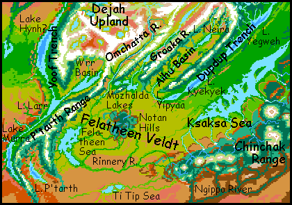
- Aihu Mts, Aihu Basin, 10 S to 5 N, 135-150 E---an arc range and basin on the southeast edge of Dejah Upland. The snowy Aihu Mountains, 6 km high (20,000') form a long front above Dupdup Trench. Behind them is the Aihu Basin, 1600 km long (1000 mi), mostly dry veldt. The basin gently rises to the north, from near desert to savanna with scattered trees; at this upper end lies Lake Neira. The Neira River runs down the length of the basin, around the Aihu Range's end, and into Dupdup Trench. The water ends up not far from its source... except it's ten km lower. (source: veltaur name)
- Mt Akor, 9 N, 112 W---A volcano in Tars Triangle, a fractured wedge of land between the Wula and Thurian Rifts, just north of Tarkas Upland. Akor is the northernmost of the four major Tars volcanoes. Smallest, too--Akor's no bigger than Ararat or Kilimanjaro, around 5.5 km (18,000'). (source: E.R. Burroughs)
- Lake Alinne, 43-50 N, 15 W---The middle trenchlake in Roop Basin, just northwest of Thuvia Upland. Alinne is about 480 km long (300 mi), and 3 km (10,000') below datum, with air dense enough to support trench wingbok, though some mops and camaroos live here as well. Lake Yikla lies just to the south. (source: wingbok name)
- Lake Amhor, 46 N, 180 W---a narrow lake 500 km long (300 mi) in Kantol Rift north of Thoris Upland. Amhor changes color seasonally; the bottom seethes with hot springs and tufa towers; its mineral balance is peculiar and its bacterial population unique and quite dense in summer; the lake never freezes in winter, but there is a large surface die-back. (source: E.R. Burroughs)
- ANTHOR SEA, 60 S, 30-50 E---an irregular sea 1050 km (650 mi) long and half as wide, southeast of the Heloon Desert. Cooler and rainier than the desert, Anthor's shores support open evergreen forests. The soil is sandy and shifting; though the woods stabilize it, dunes break through here and there. In wetter eras Anthor fuses with the Ugor and Shaleen Seas to the west; this temporary ocean turns the southern Heloon into a prairie. (source: E.R. Burroughs)
- Antsippo Lakes, 20-25 N, 95-100 E---East of Zor Chasma, streams from Parthak Crater's ray-valleys collect on its west side in a cluster of lakes. Most are fresh, for they drain into the largest, mildly brackish Lake Antsippo, a fingerlake 160 km long (100 mi). The Mediterranean hills around them form a large oasis in the Parthak Desert. Here thotters and elaffes join plains species like lobbras, veltaurs and centahs to form a complex culture. (source: thotter name)
- Aroba Peninsula, 15 S, 98 W---A low, wooded, fertile cape, jagged in outline, 250 km (150 mi) long, in the Gathol Sea. Aroba splits Shunai Bay into eastern and western halves. Densely settled by bos, veltaurs, and centahs, with thotters along the coasts. (source: bo name)
- Lake Arroo, 18-32 N, 115 E--- A freshwater lake 150 km long (90 mi) in Yoof Trench, feeding much larger Lake Hoom just to the north. The valley floor, 5 km below the plains, is hot and dry--too hot for most Tharnians. But lebbirds irrigate orchards here, and thotters fish the freshwater lake. (source: lebbird name)
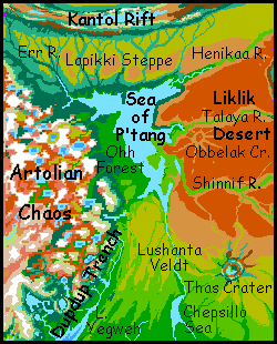
- ARTOLIAN CHAOS, 15-35 N, 160-175 E---a bizarre region of jumbled mountains and lake basins, 1600 km (1000 mi) across, on the far side of the world from Heloon Crater, created by the convergence of shockwaves from that great impact. (source: E.R. Burroughs)
- LAKE AU, 1-18 N, 55-65 E---a huge trenchlake nearly 2000 km long, in Mrr Trench east of Thuvia, from 0-18 N. Au is the lebbird cultural heartland. The shores look like jungle; actually, they're carefully tended orchards. Au is pronounced with a rising tone: "Ow?" (source: lebbird name)
B -- jump to A - B - C - D - E - F - G - H - I - J - K - L - M - N - O - P - R - S - T - U - V - W - Y - Z - Names - Sounds
- BANTOOM BASIN, Bantoom Sea, 22-29 S, 170 E---the Bantoom Sea is a salty shallow lenticular bedlake, 500 km (300 mi) long, between Wula Rift and Tarkas Upland. The endless desert flats around it, 2-3M sq km (perhaps a million sq mi) are called the Bantoom Basin. (source: E.R. Burroughs)
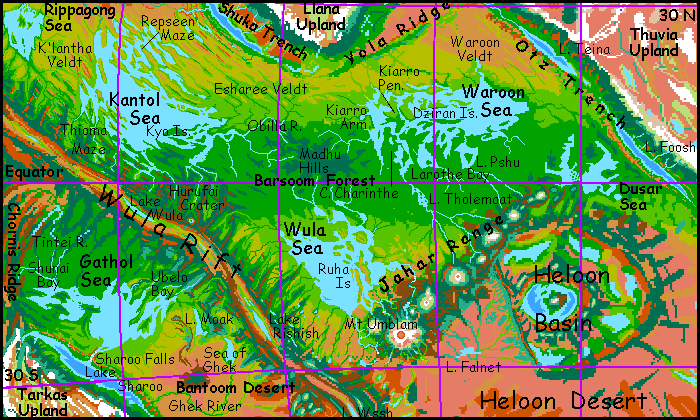
- BARSOOM BASIN, 30 N to 25 S, 15 E to 110 W---Tharn's largest and most fertile basin, with five seas; the Kantol Sea is the world's biggest, and the Waroon and Wula aren't far behind. Barsoom straddles the equator; wide savanna belts flank a rainforest strip. The Heloon Desert to the southeast is part of the same geological basin, together comprising a fourth of Tharn's surface; but the sub-basins, divided by the Jahar Mts and the walls of huge Heloon Crater, are ecologically and culturally so distinct that Tharnians never see them as a unit. (source: E.R. Burroughs)
- Brako Islands, 50 N, 120 W---islands in the central Raksar Sea, dividing it from Ulvas Bay to the west. Only two narrow straits link Ulvas to the main sea. The islands are debris from Ombra Crater just north of the sea. The largest of the Brakos is about 80 km across (50 mi); all are covered in evergreen forest. Most inhabitants are mops, with some thotters along the shores. (source: mop name)
- Bundaroo Sea, Bundaroo Valley, 1 N to 3 S, 32 E--- a leaf-shaped sea just 320 km long and 130 wide (200 by 80 mi), in southwest Thuvia Upland. Bundaroo is brackish, and lies 2.5 km (8000') up. Orbital winters get cold, but snow is quite rare and the shores are densely wooded--Bundaroo's on the equator. Many subtropical rainforest species reach up into this valley. Here at the foot of Himalayan peaks live the highest-altitude bos on Tharn; it's the only place they mix with cold-adapted camaroos and mops from upriver, who find the dense shady woods hot but tolerable. They seem to find each other hilarious; trade is brisk and villages increasingly mixed.(source: bo name)
- Bwekko Crater, 47 S, 3 W---an impact crater in the south-central Heloon Desert. 80 km wide (50 mi), Bwekko is quite dry, with only a small marsh in its depths. (source: flyote name)
C -- jump to A - B - C - D - E - F - G - H - I - J - K - L - M - N - O - P - R - S - T - U - V - W - Y - Z - Names - Sounds
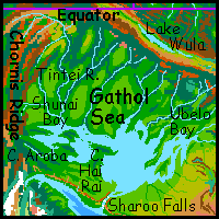
- CHANATH TRENCH, 20-60 S, 75-90 W---A major trench, on the east side of Tarkas Upland, west of Bantoom Basin. In it lie (S to N) Lakes Tavia, Yoseno and Sharoo. Sharoo is fed by Niagara-like Sharoo Falls, from the Gathol Sea. Home of rare trench wingbok and trench flyote civilizations. (source: E.R. Burroughs: Tjanath).
- Chandika Islands, 10 S, 140-150 W---An island chain down the middle of the shallow Ksaksa Sea. The biggest of the nine islands is Wantholuma, some 300 km long and 120 wide (190 by 75 mi; triple the size of Hawaii). Equally large is the Chandika Peninsula, geologically one of the chain but linked to the north shore by a narrow neck. All the Chandikas are warm, wooded and fertile; prime thotter habitat. (source: thotter name)
- Charinthe Bay, Cape Charinthe, 5 N, 35 W---Charinthe Bay, a meandering sound 500 km long (300 mi) is the Waroon Sea's southwestern corner. To the west lies Cape Charinthe, a dense tropical forest the size of Java between Charinthe Bay and the southern Kiarra Arm. To the east is similar Cape Larothe. (source: thotter name)
- Chepsillo Sea and River, 5 N, 180 W---the equatorial Chepsillo Sea is 450 km long and 220 wide (280 by 140 mi). The name's deceptive; it's a freshwater lake, but in a region bereft of any other large bodies of water, locals call it a sea. Its source is the Chinchak Range; the Chepsillo River flows north through the rainforest of Polodona, to the "Sea", which drains north over 1000 km through steadily drier lands to the true, salt Sea of P'tang. (source: thotter name)
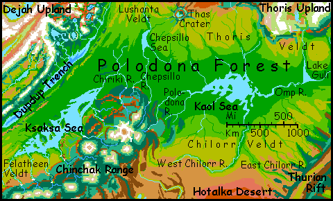
- CHILORR VELDT, Chilorr River, 8-15 S, 150-170 W---Chilorr is a savanna east of the Chinchak Range and south of the Kaol Sea. Chilorr is treeless in the south where it fades into the Holtalka Desert; scattered trees merge into the fringe of Polodona Forest in the north. Most locals live on the forks of the Chilorr River. The west branch is snowmelt from the Chinchaks; the muddy east branch rises in the ridgelands of Thurian Rift. (source: centah name)
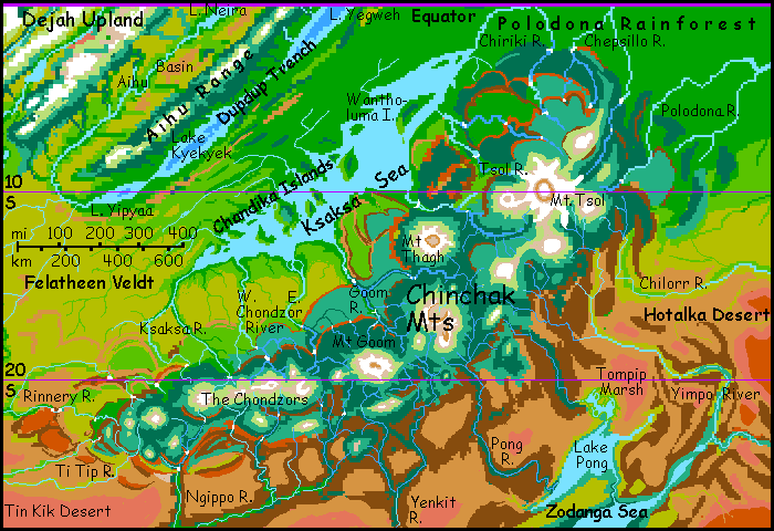
- CHINCHAK RANGE, 5-25 S, 130-180 E---a shield-volcano chain south of the Ksaksa Sea. Mt Tsol, at the east end, is 16.4 km high (54,000'), the highest in the world; central Mt Thagh tops 15 km (50,000') and three more top 12 km (40,000'). Little multicellular life survives above 10 km, but lower down, mamooks graze on lichenfields, alps sustain camaroos herders, mop woodcarvers inhabit misty woods, and great lava terraces are home to centahs, lobbras, and others. (source: centah name)
- Chiriki River, 5 N to 10 S, 170-180 E---a river in Polodona Forest, flowing 1450 km (900 mi) from Mt Tsol in the Chinchak Range down over three great falls to the north end of the Ksaksa Sea. (source: thotter name)
- Lake Ch'mal, 23 S, 160 W---a small triangular lake east of the Zodanga Sea and west of Thurian Rift. The lake's 200 km long and 120 wide (125 by 75 mi); this modest body is the largest in the Hotalka Desert, an arid plain as big as Western Europe.(source: centah name)
- The Chondzors, 20 S, 150 E---the Chondzors are a chain of four shield volcanoes, all 10-12 km high (33-40,000'); the westernmost major peaks of the Chinchak Range. They form a long east-west wall sheltering the fertile Ksaksa Sea region from the dry winds and sandstorms of the Tin Kik Desert. (source: mamook name)
- Choombra Steppe, 40-50 S, 160-180 W---a cold windy steppe southeast of the Zodanga Sea; the southern half near Thurian Rift is frozen most of the year. It's so poor even mamooks can't live off the land; they mining and trade to get by. They also colonized the Chinchak Range to the north, an epic immortalized in the Tale of Choombra. (source: mamook name)
- Chornis Ridge, 5-15 S, 110 W---the largest of the compression ridges (dorsae) in Tars Triangle. Chornis is a single straight ridge 3-4 km high, running nearly 900 km (560 mi) north from Tarkas Upland. Its north end frays into a fan of lesser ridges, Manacha Fan, running another 900 km to Mt Ikos. The ridgetop, from 5 to 50 km wide (3 to 30 mi) wide, is alpine or subalpine; the faces are steep, in places sheer. Valleys are semiarid grass and scrub, with some trees in sheltered cliff-bays and along streams. (source: centah name)
D -- jump to A - B - C - D - E - F - G - H - I - J - K - L - M - N - O - P - R - S - T - U - V - W - Y - Z - Names - Sounds
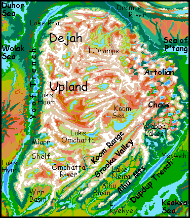
- DEJAH UPLAND, 5-45 N, 110-160 E---a continent-sized plateau, the second largest on Tharn. It stretches north from the equator inside the arc of the Zor and Kantol Rifts. To the south rises the Chinchak Range. Western Dejah is mostly high, near-Martian barrens. The east end is a peculiar lake district called the Artolian Chaos; the north is broken by the relatively fertile alpine basin of the Drampe River. Dejah breaks into ranges and subalpine basins south of the central Koom Sea. (source: E.R. Burroughs)
- Dokko La Range, 0-25 N, 40-60 E---a snowy chain 2500 km long, up to 7 km high (23,000'), the Dokko Las are the southeast rim of Thuvia Upland, between the Zazor Altiplano and the low, dry Foori Basin. (source: flyote name)
- DOR TRENCH, 15-55 S, 60-70 E---The great trench east of Sola Upland. Lake L'ree is at the north end, Lake Hhurr and the River Iss at the south end. Dor itself is just the southern third of the Mrr Trench complex. (source: E.R. Burroughs)
- Drampe River, 32-54 N, 140-160 E---the main river draining northern Dejah Upland. C-shaped Lake Drampe, 190 km long (120 mi), collects streams in the alpine upper basin; below the lake is a wide subalpine plateau. The Drampe eventually flows north off Dejah Upland and bends sharply west to drain into the Duhor Sea. The river's 1900 km long (1200 mi), though its source and delta aren't far apart! (source: mamook name)
- DUHOR SEA, 50-57 N, 115-140 E---a cool, rainy, brackish sea 1000 km long and 300 wide, dotted with wooded islands like the Gok Archipelago. It's much like our Baltic. The heart of Rronk Forest, Duhor lies north of Dejah Upland. (source: E.R. Burroughs)
- DUPDUP TRENCH, 12 N to 13 S, 135-170 E---the long trench southeast of Dejah Upland. In its depths are Lakes Yegweh, Kyekyek and tiny Yipyaa. Dupdup is flyote country; at least they're the only flying people who've settled this large air oasis; veltaurs, lobbras and thotters live here too, but being wingless, only enjoy the dense air's secondary benefits: a stable, hot climate, good for irrigated farming. Lebbirds and wingbok have not yet reached this trench, though if they do, they could certainly fly here. (source: flyote name)
- DUSAR SEA, 8 N to 2 S, 10 E to 5 W---a two-lobed, roughly H-shaped equatorial sea; each lobe is about 800 km long and 2-300 wide. Dusar lies at the east end of Barsoom Basin, dangerously near the lip of Otz Trench. (source: E.R. Burroughs)
- Dwaalip River, 35-40 N, 65-75 W---the Dwaalip drains western Llana Upland. The river runs west into Barsoom Basin, turns sharply south, and pours down into Lake Shuka on the floor of Shuka Trench; all told, some 2000 km (1250 mi). (source: flyote name)
- Dzel Seas, 38-48 N, 32 E---Twin salt lakes in central Thuvia Upland. North and South Dzel are each about 300 km (almost 200 mi) long. These fingerlakes lie end to end in a marshy valley with no outlet, 4.5 km above datum (14,800' up), between north-south compression ridges rising to 7.5 km (24,600'). High and treeless, the grassy Dzel Valley is still an oasis--most of central Thuvia supports only lichens. (source: mamook name)
- Dziran Islands, 7-12 N, 20-30 W---Two parallel east-west chains in the central Waroon Sea, in Barsoom. The Dzirans stretch 800 km (500 mi) east from Cape Kiarro. Warm and wooded, with thotter villages on the shores. (source: thotter name)
- Dzuralthe Island, 47 S, 115 E---A slender wedge of forest, 250 km long and 60 wide at its blunt east end, near the north shore of Thark Sea. A center for thotter aquaculture. (source: thotter name)
E -- jump to A - B - C - D - E - F - G - H - I - J - K - L - M - N - O - P - R - S - T - U - V - W - Y - Z - Names - Sounds
- Enk Tundra, 55-65 S, 95-140 E---a cold, windy, grassy plain south of Thark Sea. Not strictly tundra (for it has little permafrost), but frozen most of the year. Nearly as big as Alaska, it's the largest such "tundra" in the southern hemisphere. (source: mamook name)
- Err? Bay, and River, 32-43 N, 165-180 E---Err? Bay is a triangular gulf, 350 by 260 km (220 by 160 mi), northwest of the Sea of P'tang. Into it flows the Err? River, some 600 km long. "Err?" is a rough transliteration of the native elaffe name--a deep, creaking yawn with a rising pitch. The western forks of the Err? rise in the icy peaks fringing huge Dejah Upland; they collect in Err? Valley and flow southeast to the Sea of P'tang. The East Err? rises in the ridges of the Kantol Rift, just south of Lake Amhor, flowing south across the Lapikki Steppe to join the West Err? only 100 km from the shore of Err? Bay. (source: elaffe name)
- ESHAREE VELDT, 8-18 N, 45-75 W---Esharee is a rolling savanna north of the Madhu Hills in central Barsoom. Northern Esharee is dry grassland, with trees only along branches of the Obilla River, which run parallel down straight canyons called fossae. To the south the land levels and the trees spread into a patchwork. (source: veltaur name)
- Mt Ethas, 8 N, 110 W---A volcano in Tars Triangle, a fractured wedge of land between the Wula and Thurian Rifts, just north of Tarkas Upland. Ethas, the easternmost of the four largest peaks, is taller than Denali or Aconcagua--7 km (23,000'). (source: E.R. Burroughs)
F -- jump to A - B - C - D - E - F - G - H - I - J - K - L - M - N - O - P - R - S - T - U - V - W - Y - Z - Names - Sounds
- Falnet Scarp, 15-30 S, 10 W---A long line of cliffs and steep slopes up to 4 km high, dropping into Heloon Basin from the west. Falnet marks where the basin was split long ago by Wula Rift. (source: centah name)
- Lake Falnet, 26 S, 25 W---a lake 300 km (190 mi) long and half as wide, in the dry veldt basin just west of Heloon Crater and south of the Jahar Range. The lake's fairly stable, fed both by snowmelt from the Jahars and by summer thunderstorms. (source: centah name)
- Felatheen Sea, FELATHEEN VELDT, 8-25 S, 110-150 E---A bedsea 800 km (500 mi) long, but wider than 100 km only at its north end. Felatheen's shores are marshy and flat; it's just the low point in a wide veldt east of the P'tarth Mts, and northwest of the Chinchaks. The veldt extends east well beyond the Notan Hills: in all, nearly 2 M sq km (800,000 sq mi). (source: centah name).
- LAKE FELKA, 2-16 N, 120 W---The largest riftlake in the world, 1200 km long but never more than 100 wide. Felka lies in Tars Triangle where the Thurian, Wula and Kantol Rifts all meet; it stretches along the floor of Thurian Rift southwest from the juncture. Lake Felka's up to 300 meters deep (1000') in spots, extraordinary for Tharn; hot mineral springs feed algae and bacteria that stain the lake purple in late summer. (source: thotter name)
- Lake Fentho, 36 S, 165 E---A lake 200 km long and half as wide (125 by 60 mi) just north of Zodanga Sea. The shores are evergreen forest, though this thins to prairie not far north. (source: centah name)
- FOORI BASIN, Foori Sea, 22 N to 7 S, 40-60 E---a leaf-shaped arc basin--a semi-arid steppe 2700 km long and 5-600 wide (1700 by 3-400 mi), ranging from 1 to 2.5 km above datum. The brackish Foori Sea, in the south-center, is a rough oval 550 km long (330 mi). Lake Kitlei, to the northeast and two km higher up, is two-thirds as large. The basin lies southeast of Thuvia Upland, between the Mrr Mountains and the Dokko La Range to the northwest. (source: veltaur name)
- Lake Foosh, 1-13 N, 7-15 E--- over 1000 km long (650 mi) but only 80 km (50 mi) wide, Lake Foosh lies just north of the equator in Otz Trench, just east of the Dusar Sea, which may eventually drain catastrophically into it. Until it does, though, Foosh will remain a haven for wingbok, who find flying easy in its dense air. (source: veltaur name)
G -- jump to A - B - C - D - E - F - G - H - I - J - K - L - M - N - O - P - R - S - T - U - V - W - Y - Z - Names - Sounds
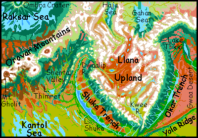
- Gahan Tundra, Gahan Sea, 45-65 N, 45-70 W---a wide tundra basin due north of Llana Upland. Two seas drain the tundra: Gahan Sea, 800 km long (500 mi), lies at its south end; and in the far southwest, Lake Haja lies beyond the snowy Haja Range. It's nearly as long as Gahan, but much narrower: too small to moderate the local climate much.(source: E.R. Burroughs)
- GATHOL SEA, 10-20 S, 80-105 W---a large sea southwest of the Wula Rift, 1450 km (950 mi) long and half as wide, with a wildly irregular shoreline--Ubelo and Shunai Bays are nearly as big as the central sea. Gathol is a freshwater lake; it drains over Sharoo Falls down to Lake Sharoo, deep in Chanath Trench just east of Tarkas Upland. (source: E.R. Burroughs)
- Gedda Bay, 30 S, 175 W---The northeast end of Zodanga Sea, Gedda Bay's a marshy triangle 300 km on a side, fed by Lake Pong and the Yimpo River. The only part of Zodanga with treeless shores. (source: bo name)
- Lake Gerboon, 5-9 N, 89 E (disputed: caravan maps have 82 E)---Lake Gerboon is a sinuous finger 250 km long and 70 wide (150 by 45 mi). One of the four Vad Lakes in the foothills of Zor Chasma west of the Varo Sea, Lake Gerboon drains north, then east, then south again into West Zhirada Bay on the Varo Sea. The Gerboon Valley is open woods; rainfall is high for Tharn, but noticeably less than the Varo plain to the east; the intervening ridges, though low, snag much of the rain, and Gerboon is furthest north, closest to Shen Veldt. (source: bo name)
- Gerpook River, 28-35 S, 150-170 W---A shallow river 1500 km long (930 mi) running from southern Thurian Rift to the Zodanga Sea. Most of the locals (camaroos and mops) live on Lake Gerpook on its north fork. (source: mop name)
- Ghadoor Bay, 3-7 N, 98 E (disputed; may be as little as 92 E)--- The largest bay on the Varo Sea, on its northeast shore. Ghadoor is a leaf-shaped basin 250 km long and 100 wide (150 by 60 mi); rainforested Ghadoor Island and Cape Ghadoor divide it from the main sea. The bay is freshwater, and the shores have thotter fishing villages; bos live inland. (source: bo name)
- GHASTA TRENCH and GHASTA SEA, 45-62 S, 120-150 W---a "birdsea"--a trenchlake that's filled up to the plains level and spilled out across them. Y-shaped Ghasta's 1300 km long (800 mi), medium-sized for a Tharnian sea, but is so deep it holds possibly one-twelfth of all liquid water on Tharn. It lies southwest of Tarkas Upland. (source: E.R. Burroughs)
- Ghek River, Lake Ghek, 20-38 S, 55-87 W (Disputed; the delta may be as little as 81 W)---a large river 2600 km long (1560 mi) feeding Lake Sharoo in the Chanath Trench east of Tarkas Upland. The southern fork flows due west from the pine-forested ridges of Wula Rift; the northern flows from Lake Ghek, 400 km long (250 mi). (Source: E.R. Burroughs)
- Mt Gholit, 33 N, 102 W (disputed; may be only 98 W. This region is little traveled)---Highest peak in the Orovar Range. A massive shield volcano resembling Mars's Olympus, Mt Gholit is 16 km high (50,000'). It rises at the southwest end of the range, above the Tlani Desert. (source: mamook name)
- Lake Ghoot, 27 N, 28 E (uncertain; may be as little as 22 N)---a large alpine lake in central Thuvia, about 200 km long and 100 wide (125 by 60 mi). Most of its high, cold, arid basin is fit only for mamooks; a few camaroos shepherds graze the alpine meadows around the lake. Ghoot drains south to the Trelomm River.
- Gok Islands, 53 N, 120-135 E (may be only 115-130 E)---An archipelago of four islands in the Duhor Sea. The central pair are each 160-190 km long (100-120 mi); all are dense evergreen forest dotted with mop lodges, with elaffe orchards in south-facing valleys and thotter villages along the shores. (source: mop name)
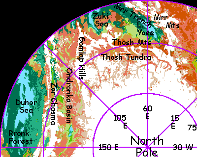
- Gomlap Hills, 53-73 N, 85-140 E---a range 2500 km long (1600 mi), north of Kantol Rift and the Ondronka Basin. The Gomlaps, though only 2 km high (6600'), are heavily glaciated; indeed, they form an icy tongue of the polar cap reaching almost to the Zuki Sea. The Ondronka River cuts through the range midway, forming an impressive canyon. (source: mamook name)
- Gomlap River, Gomlap Bay, 50-60 N, 75-80 E---a river draining the south end of the Gomlap Hills; it runs 300 km down through steppes then forest to Gomlap Bay, 120 km across, on the northeast shore of the Zuki Sea. (source: mamook name)
- Mt Goom, 15-20 S, 160-165 E (not uncertainty; it's just that big)---Mt Goom is a shield volcano 12 km high (40,000') in the central Chinchak Range. The Goom River runs north 800 km (500 mi) to the Ksaksa Sea; the upper Goom has three great waterfalls. (source: mamook name)
- Grooka Valley, 15 N to 7 S, 130-150 E---the Grooka River runs southwest off Dejah Upland. To the north is the Koom Range, to the south, the Neira, both Himalayan in height. This straight, deep valley is alpine for most of its 1600-km length, though evergreens grow along the river's lower stretches and it ends in the Mozhalda Lakes on Felatheen Veldt, barely above datum. (source: mop name)
- Guli River, Lake Guli, 0-5 N, 145 W (may only be 140 W)---The Guli River's source is km high, in south-central Thoris Upland; the river flows south, dropping in a famous fall onto Thoris Veldt and ends in Lake Guli, a triangular, freshwater sea about 300 km long by 160 wide (190 by 100 mi). To the east lies the Omp Range; to the south and southeast, Thurian Rift. The lake drains west via the Omp River to the Kaol Sea; its valley is the eastern fringe of the vast Polodona Rainforest. (source: E.R. Burroughs)
- GWAA DESERT, 25-45 N, 20-35 W---a northern tongue of Barsoom Basin, between Llana and Thuvia Uplands. It's cut off from the greener plains to the south by long Yola Ridge. (source: flyote name)
- The River Gyak, 33-57 S, 5 W to 8 E---a river 1900 km long (1200 mi) running south over the Heloon Desert, flowing into the Anthor Sea. Flyotes farm its oxbows and live in cliff-dwellings in the canyon walls. To the east runs a twin, the Koyabee. (source: flyote name)
H -- jump to A - B - C - D - E - F - G - H - I - J - K - L - M - N - O - P - R - S - T - U - V - W - Y - Z - Names - Sounds

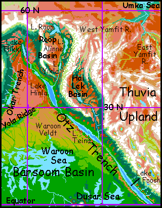
- Hai Lek Basin, 30-40 N, 0-15 W---An arc basinon the west side of Thuvia Upland. It contains a spur of Otz Trench, but Lake Hai Lek on its floor is barely below datum. The Hai Lek River collects streams descending from the surrounding Tibetan peaks, flowing south to the lake, which is shallow but 350 km long (220 mi), then on south through a deepening canyon to Lake Teina in Otz Trench; all in all, the Hai Lek is 2100 km long (1300 mi). Much of the population (and all of its fliers) live in the southern canyon. (source: wingbok name)
- Cape Hai Rai, 18-22 S, 95-100 W---An anvil-headed peninsula poking north into the Gathol Sea, cutting off Shunai Bay to the west. Hai Rai is mostly open woods, with a mild rather Mediterranean climate; densely settled by centahs, bos, and veltaurs, with thotters along the coasts. (source: veltaur name)
- Lake Haja, 55-61 N, 75 W---a narrow, shallow, slightly brackish sea 700 km long but only 100 wide (450 by 65 mi) northwest of Llana Upland. Its cold, windy, marshy shores are treeless; the basin's frozen much of the year. To the east over the snowy Haja Range, a northern tongue of Llana Upland, lies Haja's big sister: the Gahan Sea. (source: E.R. Burroughs)
- HAR TRENCH, 25-45 S, 120 W---A trench west of Tarkas Upland, 5.5 km deep, containing two trenchlakes, Lake Jeet in the north and much larger Lake Rrit in the south. The arthom originated here; it's still nearly their only home. (source: E.R. Burroughs)
- HASTOR SEA, 4 N to 12 S, 60-67 E---A pear-shaped bedsea 900 km long (560 mi) on the equator west of Zor Chasma. Invak Rainforest surrounds most of Hastor, though the southeast shore is savanna. (source: E.R. Burroughs)
- HELOON CRATER, 5-32 S, 18 E to 18 W---Tharn's largest impact feature, by far: a double-walled impact basin 2500 km across and 7 km deep. Heloon's dense air and many small seas make it a biological hotspot. The Korus Sea now fills the inner basin; the central peak is now Korad Island. The inner ringwall, the Ksana Range, is over 10 km tall (33,000+'). Outside is Tor Kvas Valley, 4-5 km deep, cupping a semicircle of lakes or small seas (clockwise, NW to SW: P'koon, Shath, Tholna, Shillim, and Kwaree). The Lothar Mts form the outer ringwall. The western third of the Heloon structure was split off long ago by the spreading zone of Wula Rift; the rest has drifted 3000 km east. (source: a tribute to Burroughs' city/land of "Helium," itself probably inspired by the Hellas Basin on Mars, since their locations coincide.)
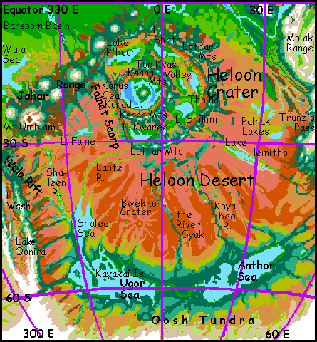
- HELOON DESERT, 15-50 S, 15 E to 15 W---Tharn's largest desert, some 10 million sq km (4M sq mi), lying south of huge Heloon Crater. Mostly flat. A fan of long, straight rivers, lakes and dry canyons (like the Koyabee R., the River Gyak, the Lante R. and Lake Hemitho) still follow the rays from the Heloon impact 400 million years ago. The southern edge fades into steppes and pinewoods around the Shaleen, Ugor and Anthor Seas. (source: indirectly from E.R. Burroughs)
- Lake Hemitho, or Hemitho Sea, 21 S, 29 E---a long, shallow, brackish but drinkable lake of variable size and shifting shoreline (even for Tharn, I mean), in the eastern Heloon Desert. Most of its water is seasonal snowmelt from Sola Upland; the alternate flooding and drought has left much of Hemitho's shore relatively barren--partly salt- and clay-pans, with some marsh, and no trees. (source: centah name)
- Henikaa River, Henikaa Bay, 32-40 N, 150-170 W---the Henikaa flows 2000 km from northern Thoris Upland west to Henikaa Bay, the northeastern arm of the Sea of P'tang. The lower Henikaa crosses the Liklik Desert, one of only three year-round streams to do so; its canyon is an oasis farmed by flyotes and lobbras. (source: wingbok name)
- Lake Hhurr, 35-42 S, 70 E---a trench lake 5.5 km below datum, in Dor Trench southeast of Sola Upland. While Lake Hhurr is small, only 500 km long, the climate's pleasantly Mediterranean and the dense air's ideal for flight, so many lebbirds have settled here. (source: lebbird name)
- Hiffa Crater, 5 N, 69 E (disputed: caravan maps show 72-75 E)---The ringwall of Hiffa Crater rises from tropical forest 500 km NE of the Hastor Sea, near Zor Chasma. The rim's 40 km wide (25 mi) and 500 m high (1600'), with a central lake 30 km wide (19 mi). Hiffa is near the edge of Invak Wood--further north, the forest opens into groves and strips along the winding rivers; semi-arboreal bos are replaced by savanna-dwellers like veltaurs and centahs. Hiffa's part of a chain of impact scars; see Shira, Zu, and Shif Shif Craters. (source: veltaur name)
- Hinarr Desert, 15-33 S, 90 E---A dry plain about 600 by 1000 km (400 by 600 mi) east of Zor Chasma, near Lelei Canyon and Lake Murra at the southern tip of Yoof Trench. (source: veltaur name)
- LAKE HINLA, 29-37 N, 15 W---a lake 1100 km long (700 mi) lying deep in Otz Trench. Its warm, dense-aired, fertile shores, 6 km below datum (one of the deepest trenchlakes on Tharn) are a biological hotspot and a wingbok heartland. (source: wingbok name)
- LAKE HOOM, 18-32 N, 120 E (disputed; may be only 115 E)---a lake 1400 km long, in central Yoof Trench, west of Dejah Upland near Parthak Crater. Its shores are the lowest point on Tharn, 7.2 km below datum. The largest flyotes and lebbirds in the world live here, and elaffes may have evolved on its northern shores. "Hoom" is a crude transliteration of the growling, deep-throated subsonic boom only an elaffe can say right. (source: elaffe name)
- HOTALKA DESERT, 10-25 S, 150-170 W---an arid plain as big as Western Europe, between the Zodanga Sea and Thurian Rift. The largest body of water is shallow Lake Ch'mal, 200 km long and 120 wide (125 by 75 mi). Streams do run down from the greener heights of the rift zone, so the region is habitable, just unappealing. Drought-tolerant centahs herd flocks here. (source: centah name)
- Hulam Mts, 47-53 N, 170 E to 170 W---A snowy east-west range 1000 km long (625 mi), just north of the Kantol Rift. Really three parallel ranges 3-4 km high. Between the North and Central Hulams lies long Lake Yaruu in a subalpine valley. (source: mamook name)
- Hurufai Crater, 8 S, 80 W---Hurufai is an impact crater about 60 km/40 mi wide just north of Wula Rift and south of the Kantol Sea. Lake Hurufai fills the crater floor, except for a craggy central island. The whole thing looks quite lunar except for the evergreen woods covering the slopes. Hurufai lies in fresh crust so close to the rift that it can't be over 10 million years old. The timing is suspiciously close to a whole chain of impacts near Zor Chasma on the far side of the world (see Zu, Shif Shif, Hiffa, Shira, Noor Nar and Washi Craters); Hurufai may have been a straggler in the same swarm of rocks. The blast must have torched the southwestern Barsoom Basin, but this rainy region has long since recovered. (source: veltaur name)
- LAKE HYNH? (a high, querelous honk), 10 N to 10 S, 105 E---an equatorial lake 4 km down in Yoof Trench, southwest of Dejah Upland; the name, in Elaffe, means "Too hot!" and it is, for those behemoths, in fact it's the hottest place on Tharn. In orbital summer, the shores can reach 320 K (117 F) in the shade--fortunately there's a lot of that, and water, too, for a belt of rising equatorial air generates year-round rains feeding a lush, hothouse forest. The lebbird tree-towns of Hynh? sleep days and live at night, under the vast golden glow of Zeus. (source: elaffe name)
I -- jump to A - B - C - D - E - F - G - H - I - J - K - L - M - N - O - P - R - S - T - U - V - W - Y - Z - Names - Sounds
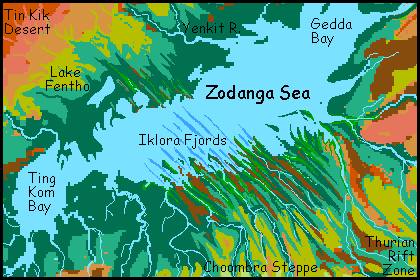
- Iklora Fjords, 40 S, 170-180 W---A set of narrow, straight capes and bays 80-160 km long (50-100 mi) but just a few miles wide. The walls, from 1-600 m high (300-2000'), range from steep wooded slopes to sheer black cliffs. These parallel fossae run inland all the way to the Thurian Rift; the most visible fracture zone on Tharn. The fjords are a center of thotter aquaculture, and flyotes farm the fossae-floors upriver, living in spectacular cliff-villages. (source: thotter name)
- Mt Ikos, 0-2 S, 105-110 W---a volcano in Tars Triangle, the fractured wedge of land between Wula and Thurian Rifts, just north of Tarkas Upland. Southernmost of the four big peaks here, it's 8 km high (27,000'), larger than Kilimanjaro or Denali. A long line of lesser cones, mere Fujis and Ararats, straggles 250 km southeast. (source: E.R. Burroughs)
- Mt Imal, 3 N, 113 W---a volcano in Tars Triangle, the fractured wedge of land between the Wula and Thurian Rifts, just north of Tarkas Upland. Highest and westernmost of Tars's four great volcanoes, Imal is 10 km (33,000'), toe to top: as high as Hawaii stripped bare of its sea. (source: E.R. Burroughs)
- Ing River, 15-24 S, 120 W---A river running from Tars Triangle 800 km (500 mi) south to Lake Jeet in Har Trench. (source: artho name)
- Lake Inkip, 3-6 N, 90 E (disputed; may be only 84 E)---Lake Inkip is a fingerlake 220 km long and at most 50 wide (140 by 30 mi). Easternmost of the four Vad Lakes in the foothills of Zor Chasma west of the Varo Sea. It drains into West Zhirada Bay. The Inkip Valley is a bit drier than the Varo Basin over the hills to the east: the forest is tall but a bit more open. (source: thotter name)
- Insoralta Peninsula and Sound, 55-58 N, 75-78 E---a broad, densely wooded cape on the east shore of Zuki Sea. To the north is Gomlap Bay; to the south, sinuous Insoralta Sound, 500 km long (300 mi). Mudbanks and kelp beds make for rich fishing and "clamming" for the local thotters. (source: thotter name)
- INVAK FOREST, 8 N to 11 S, 50-75 E---An equatorial rainforest by the Hastor Sea, west of Zor Chasma. One of Tharn's lushest forests, Invak is as big as New Guinea, or two Californias. Invak's flat, broken only by the rays of Shira Crater and the rim-hills of Yarr Trench. (source: E.R. Burroughs)
- Iss River, Lake Iss, ISS TUNDRA, 68-45 S, 60-80 E---A cold, silty, many-branched river 2250 km long (1400 mi) draining Iss Tundra, a huge cold steppe southeast of Sola Upland. Several river-arms have dug deep canyons--air oases. Lake Iss fills the floor of one. 190 km long and 20-40 wide (120 by 20 mi), the lake's one of the youngest features on Tharn, only a few thousand years old; a great landslide dammed the river. The lower Iss flows north into Dor Trench, feeding Lake Hhurr. (source: E.R. Burroughs)
J -- jump to A - B - C - D - E - F - G - H - I - J - K - L - M - N - O - P - R - S - T - U - V - W - Y - Z - Names - Sounds
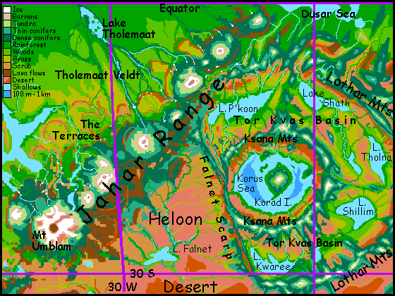
- JAHAR MTS, 5-27 S, 5-35 W---a range of overlapping shield volcanoes west of Heloon Crater, stretching 2500 km to the Wula Sea. Mt Umblam, the youngest, westernmost and highest peak, tops 16 km (52,500')--the second tallest on Tharn. Seven or eight others are Himalayan in size. Concentric climate belts ring the mountains, from Martian down through alpine, forest, savanna and desert. The western slopes are scalloped, cliffwalled, overlapping lava plateaus, like the wax at the base of a candle, called The Terraces. Each terrace has a different altitude, climate and dominant species. Snowmelt from the great volcanoes collects into large winding rivers on these plateaus, then plunges in large falls to the lower levels. (source: E.R. Burroughs)
- Lake Jeet, 25 S, 120 W---Lake Jeet lies 4.5 km deep in Har Trench, just west of Tarkas Upland. Jeet's only about 180 km (110 mi) long; the Zzeep River issues from its south end, feeding much larger Lake Rrit to the south. Its shores are orchards tended by arthom. (source: artho name)
- Joom Range, 58-67? S, approximately 180 W---a cluster of five major and many smaller volcanoes, heavily glaciated. The Jooms rise from the sparse tundra south of Thurian Rift and west of the Ghasta Sea. Central Mt Joom is the tallest, at about 12 km (40,000'). These are massive volcanoes, though steeper in slope than true shield volcanoes. Exposed to the polar winds, the southern slopes and heights above 2 km are quite barren and largely ice-mantled; but the long south slopes face the sun and block the polar winds; this subpolar microclimate supports lichen, grass and even sparse evergreens in valleys. While pastoral camaroos might just be able to survive here, Joom is extremely isolated; mamooks are the only residents. (source: mamook name)
K -- jump to A - B - C - D - E - F - G - H - I - J - K - L - M - N - O - P - R - S - T - U - V - W - Y - Z - Names - Sounds
- Lake Kalenn, 44 S, 65 W---an oasis in the Bantoom Desert; a lake 16 km across with marshy shores, nestled in the bowl of Luppa Crater. The lake is well below bedlevel, with air thick enough to support unusually large flyotes and plains wingbok so large they can speak in complete sentences. Thotters and pastoral centahs also live by its shores. (source: wingbok name)
- Kalinei Hills, 32-41 S, 60-68 W---really more than hills, the Kalinei massif is a rugged L-shaped region of blocks and canyons dividing the northern and southern Bantoom Desert; it's a fracture zone full of cracks and ridges at right angles, caused by huge Wula Rift to the east. Just to the south lies Luppa Crater. Streams from the Kalinei canyons feed the Bantoom Sea. The Hills are sparsely populated: thotters live along the streams, and small, semi-intelligent flyotes farm some canyons; a few pastoral centahs and camaroos herd flocks in grassy valleys, while a small, rustic subspecies of wingbok graze the grass directly. None of these groups are numerous; the land is just too harsh to support much. (source: wingbok name)
- KALTAVEN BASIN, Kaltaven Range, 30-45 S, 85-100 W---an arc basin on the eastern edge of Tarkas Upland. Kaltaven's floor is fully two km high (6600"), so it's not desert like most arc basins, but a steppe 1000 km long and hundreds wide. On the east side the Kaltaven Range rise 5 km (16,000') to a height of 7 km (23,000') above datum; their spectacular east face drops over 12 km (40,000') into the Chanath Trench. (source: E.R. Burroughs: Kal Taven.)
- KANTOL RIFT, 15-60 N, 115 W to 135 E---Kantol is a chasma, a sinuous double ridge where new crust is spreading, like our East African Rift. Kantol's thousands of km long; it snakes north of Thoris Upland, approaches the northern icecap, then curves south as Zor Chasma--geologically they're just different stretches of the same feature. The coldest of the rift zones, Kantol's twin ridges and even its central rift valley are largely evergreen forest, alpine, or glaciated. (source: E.R. Burroughs)
- KANTOL SEA, 2-23 N, 60-82 W---this bedlake in West Barsoom is the biggest sea on Tharn, 2400 km long and 1600 wide (1500 by 1000 mi), though shallow and broken by endless islands--low, curving ridges forming marshy labyrinths at the north end (Repseen Maze), southeast (Kyo Islands) and southwest (Thioma Maze). The north and west shores are veldt; the south and east, rainforest. (source: E.R. Burroughs)
- Kaol Sea, 1 N to 6 S, 155-166 W---an equatorial sea in eastern Polodona, southwest of Thoris Upland. Kaol is a rough diamond-shape, 700 by 500 km across (450 by 300 mi), with a convoluted coast and many small islands, all lushly wooded--it's the east end of Polodona Rainforest. Slightly brackish and tannin-stained, Kaol's still quite drinkable. (source: E.R. Burroughs)
- Kayakai Islands, 55-60 S, 20 W---Three large and many small islands in the northern Ugor Sea. The Kayakais are cool and mild, a patchwork of conifer woods and meadows. Most residents are thotters, mops, or the endemic "flightless" subspecies of wingbok (actually, most can fly short distances). (source: wingbok name)
- Kiarro Peninsula, Kiarro Arm, 6-13 N, 36 W---Tortuous Cape Kiarro winds over 500 km (300 mi) south into the Waroon Sea, nearly cutting off a great western sound, the Kiarro Arm. To the east, the same rise forms the Dziran Archipelago. Thotter villages line all these warm, wooded shores. (source: thotter name)
- Kindasharo Island, 26 S, 72 E---A leaf-shaped island in the Proom Sea; 120 km (75 mi) long, by far the largest in Proom. Kindasharo's the debris apron from Washi Crater in its center, 20 km wide. The island's Mediterranean in climate, with forest only in canyons and up on the rain-catching heights of the Washi ringwall. Still, it's a pleasant oasis compared to the Proom Desert surrounding the sea. (source: thotter name)
- Lake Kitlei, 15-19 N, 60 E---Lake Kitlei is a freshwater sea 320 km (200 mi) wide, at the north end of Foori Basin southeast of the Thuvia Upland. Kitlei Valley lies from 1.5 to 2.5 km high (5-8000'); it's mostly a cool, treeless steppe. The Kitlei River drains the lake, running 700 km southwest, down to the Foori Sea. (source: wingbok name)
- K'LANTHA VELDT, 11-27 N, 80-93 W---the warm grassland between the Kantol and Rippagong Seas. Long finlike ridges (the last gasp of the fracture zone around Wula Rift to the south) break the grassy plain, forcing all the streams to run parallel. These ridges often end in redrock scarps on the northeast face, giving K'lantha a desert look that's deceptive; storms can blow in off either sea, so rainfall's fairly high and reliable for Tharnian veldt. (source: centah name)
- Koba Arm or Koba Gulf, 55-62 N, 102-109 W---a great bay curving north at the east end of the Raksar Sea. Koba is about 400 by 500 km (250 by 300 mi). (source: mop name)
- Koom Sea, 12-18 N, 145-153 E---a brackish lake in east-central Dejah Upland, fully 800 km (500 mi) long. Twin basins, each 300 km wide, are linked by a long narrows. Koom is by far the largest lake in Dejah, and a center of mamook culture, fed by the rich grass of its alpine shores. (source: mamook name)
- Korad Island, 17-23 S, 1-5 W---a mountainous island in the Sea of Korus. It's the central peak of the inner impact basin of Heloon Crater, largest on Tharn by far. Fully 11 km (36,500') tall, Korad is one of Tharn's tallest nonvolcanic peaks. But not the highest; its base rises from 7 km (23,000') below bedlevel! Even so, the summit's high enough for snow, and even a few glaciers. Korad's a weird parallel to Earth's Hawaii--if Tharn had enough water to fill Heloon to datum/bedlevel, it'd be a near-twin of Mauna Kea. (source: E.R. Burroughs)
- Korus Sea, 15-25 S, 2 E to 10 W---a lake 7 km (23,000') down on the crater floor of Heloon, the largest impact feature on Tharn. Korus is 900 km across (560 mi), though nowhere are you more more than 160 km (100 mi) from land. Its shores are extremely fertile due to the high air pressure, comparable to Earth only 3-4 km up--merely Alpine! The sea is ring-shaped, with a great mountain rising from its center: Korad. (source: E.R. Burroughs)
- Koyabee River, 33-55 S, 25 E---a river 2000 km long (1250 mi) in the southern Heloon Desert, flowing into the Anthor Sea. Flyotes farm its oxbows and live in cliff-dwellings in the canyon walls. It has a western twin, the River Gyak. (source: flyote name)
- KSAKSA SEA, Ksaksa Stairs, 1-14 S, 148-168 E---a triangular equatorial sea at the feet of the Chinchak Range. The shores are wooded, though they quickly thin to savanna to the south and west. Ksaksa is a good 1800 km long (1130 mi); the large, fertile Chandika Islands run down its middle. Half a dozen species share the region, attracted by the mild climate and the beauty of its capes, bays, and islands. An even bigger attraction are the Ksaksa Stairs, a set of wooded, cliffwalled plateaus rising like a stair to the southeast into the Chinchak Range. Snowmelt from the great volcanoes above collects into large winding rivers on these plateaus, then plunges in large falls to the lower levels. Similar lava-shelves create similar falls in the Terraces on the west side of the Jahar Range. (source: E.R. Burroughs, spelled Xaxa)
- Ksana Mts, 12-27 S, 5 E to 10 W---the inner ring-range of the huge impact crater of Heloon. The Ksanas are up to 10 km tall (33,000'), yet their summits are snowless in summer, for they rise from a deeply sunken basin, reaching only three km (2 mi) above datum. (source: E.R. Burroughs)
- Lake Kwaree, 28 S, 3-10 W---a lake 600 km long (380 mi) in Heloon Crater. Kwaree lies in the southwest end of Tor Kvas Basin, between the Ksana and Lothar Ranges (the inner and outer ringwalls). To the northeast lies Lake Shillim, next in the chain. (source: centah name)
- Kwee River, 18-30 N, 45-60 W---a river 1200 km (750 mi) long, draining the southern third of Llana Upland. Most of its course is through alpine meadows, but the last third is unbroken rapids, dropping nearly 10 km into Shuka Trench. (source: mamook name)
- Lake Kyekyek, 5-10 S, 142-152 E---a narrow trenchlake 660 km long (415 mi), in Dupdup Trench, the long trench southeast of Dejah Upland. Kyekyek is the deep point of the trench, fully 6.5 km below datum. Lake Yegweh, nearly twice as big, feeds it from the north; tiny Lake Yipyaa, from the south. Dupdup Trench is flyote country; at least they're the only flying people who've settled this large air oasis; veltaurs, lobbras and thotters live here too, but being wingless, only enjoy the dense air's secondary benefits: a stable, hot climate, good for farming and orchards. Lebbirds and wingbok have not yet reached this trench, though if they do, they could certainly fly here. (source: flyote name)
- Kyo Islands, 3-6 N, 75-80 W---an archipelago of eight low, hilly islands up to 200 km long (125 mi) in the southeastern Kantol Sea, in Barsoom. Tropical forest covers most of the Kyos, though the drier northern islets have some open meadows. Most residents are bos and thotters. (source: thotter name)
L -- jump to A - B - C - D - E - F - G - H - I - J - K - L - M - N - O - P - R - S - T - U - V - W - Y - Z - Names - Sounds
- Lante River, 30-42 S, 10-25 W---modest in flow but 1100 km long (700 mi), the Lante rises in the western Lothar Range, the outer ring-wall of Heloon Crater. The Lante flows south through the western Heloon Desert to the Shaleen Sea; its long green valley is the best route for caravans over the desert to the southern forest belt. (source: wingbok name)
- Lapikki Steppe, 35-45 N, 170 E to 170 W---Lapikki is a cool, windy, semi-arid plain north of the Sea of P'tang. Only three rivers cross the steppe: from west to east, the Errr?, East Errr?, and Lapikki; all three flow south from Kantol Rift Zone to the sea. (source: flyote name)
- Larothe Bay, Cape Larothe, 2-7 N, 30 W---A triangular bay 270 km long (170 mi) on the convoluted south shore of the Waroon Sea. It's nearly a separate lake. Just west lies Cape Larothe, a wedge of dense tropical forest the size of Java. To the east is similar Lake Pshu. (source: thotter name)
- Lake Larr, 11-13 S, 110 E---A triangular trenchlake 200 km long (130 mi) lying in the junction where small Wrr Trench joins Yoof Trench. The lake lies fully 3 km below datum, with dense air even Earth creatures could nearly breathe. Its depth and low latitude make Larr one of the hottest places on Tharn. The shores are lush; the plains above the trench are savanna, but heat-adapted forest rings the lake and lebbirds have planted great orchards. The lake drains south to salty Lake Murra. (source: lebbird name)
- Lelei River, Canyon, Veldt, Islands, 3-18 S, 95-105 E---The Lelei River drains the equatorial, freshwater Varo Sea. The south end of the sea narrows and fills with leaf-shaped islands where thotters flourish: a delta in reverse, like Lake Ontario's Thousand Islands. Both isles and shores are rainforested. The Lelei runs south; the forest slowly thins to savanna. The river cuts a canyon through Lelei Veldt, eventually becoming a spectacular gorge 3 km deep (2 mi). Its mouth opens into Yoof Trench, where the Lelei drains into salty Lake Murra, 3.5 km below datum. The canyon's thick warm air supports two of Tharn's four winged peoples: the walls are riddled with the cliff-dwellings of full-sized flyotes, plus a significant minority of lebbirds. (source: flyote name)
- LIKLIK DESERT, 17-40 N, 155-175 W---Liklik is the largest desert in the northern hemisphere--a flat red plain 2000 by 1200 km across (1250 by 750 mi), stretching west from Thoris Upland to the Sea of P'tang. It's broken only by three river-canyons (the Henikaa, the Talaya and the Shinnif) and by Obbelak Crater. (source: wingbok name)
- LLANA UPLAND, 22-50 N, 40-75 W---a "continental" plateau the size and shape of India, north of the Barsoom Basin. To the northwest is Lake Haja; Lake Gahan is due north. Long, straight Himalayan ranges march along the southern edges, dropping into trenches: Shuka Trench to the southwest, Okar to the southeast. (source: E.R. Burroughs)
- LOTHAR MTS, 5-32 S, 18 E to 18 W---the outer ringwall of the huge impact crater of Heloon. The Lothars shelter Tor Kvas Valley, between the inner and outer walls, and half a dozen large lakes. Their outer faces are only 3 km tall (10,000'), snowy only in winter; but the inner slopes are 7-6 km tall, since the Tor Kvas basin is 4 km below datum (Tharn's equivalent of sea level). (source: E.R. Burroughs)
- LAKE L'REE, 14-25 S, 60-70 E---a major trenchlake 1300 km (800 mi) long, in Dor Trench east of Sola Upland; its shores are 3.5 km deep, with the air thick enough for easy flight, so it's densely settled by lebbirds. (source: lebbird name)
- Luppa Crater, 44 S, 65 W---an impact crater 90 km (55 mi) across, in the Bantoom Desert east of Tarkas Upland. It's unusual in that the crater's new enough to have rays visible from space and a central bowl 1.7 km deep (over a mile), yet the walls are low--less than a km (3300'). This has ecological consequences: the low walls don't block winter storms, but the bowl traps snowmelt. So Luppa's become an oasis of warmth, denser air, AND water. Flyotes, wingbok, thotters and centahs all live here, around shallow Lake Kalenn. (source: flyote name)
- LUSHANTA VELDT, 8-20 N, 170-180 E---Lushanta is a savanna east of Dejah Upland. 1000 km (600 mi) wide, Lushanta is a warm rolling plain dotted with trees, thickening to groves and open woods in the south--the fringes of Polodona Rainforest. Lushanta's east edge is the Chepsillo River, running north to the Sea of P'tang. (source: centah name)
M -- jump to A - B - C - D - E - F - G - H - I - J - K - L - M - N - O - P - R - S - T - U - V - W - Y - Z - Names - Sounds
- Madhu Hills, 0 N, 45 W---the rainforested central hills of the Barsoom Basin, between the Waroon, Wula and Kantol Seas. Neither volcanic nor associated with a trench, the Hills are probably a corona. (source: bo name)
- Manacha Fan, 0-16 S, 105-115 W---a wedge of compression ridges just south of Tars Triangle, where three rifts meet. The largest is Chornis Ridge, a single straight ridge 3-4 km high, running nearly 900 km (560 mi) north from Tarkas Upland. Its north end frays into a fan of lesser ridges running another 900 km to Mt Ikos. Manacha's ridgetops range from bare rock to alpine meadows and forests. Valleys are semiarid grass and scrub, with some trees in sheltered cliff-bays and along streams. (source: E.R. Burroughs: Manatja)
- MANATOR SEA and MANATOR VELDT, 5-25 S, 122-132 W---a narrow, broken sea 1300 km (800 mi) long. Manator lies west of Tarkas Upland, just south of the equator. The sea's south end trails off in a long chain of brackish desert lakes leading nearly to the Ghasta Sea The northern shores are a flat savanna larger than Texas: Manator Veldt. (source: E.R. Burroughs)
- Manlat River, Manlat Arm, 28-40 N, 78-85 E---a river 800 km (500 mi) long running from Zor Chasma (near Lake Manlat, though it doesn't drain it--the riftlake has no outlet) down to Manlat Arm, a bay about 240 km (150 mi) long on the Zuki Sea. (source: E.R. Burroughs: Man-Lat)
- Lake Manlat, 20 N, 83 E---a rift lake lying deep in Zor Chasma, near Zu Crater. Peanut-shaped, the lake is 250 km long and 125 wide (160 by 80 mi) . It's fed by hot mineral springs--"black smokers"--sustaining unique sea-life. (source: E.R. Burroughs: Man-Lat)
- Miarr Shelf, 8-12 N, 120 E---A relatively fertile alpine lake-basin on the western rim of Dejah Upland. Miarr resembles the Ethiopian Highlands in size, latitude and altitude, though the climate's harsher, with strong seasons due to Tharn's orbital eccentricity. Still, it's mild for a Tharnian upland. Its four large (and hundreds of small) lakes all drain into Yoof Trench. Miarr supports a dense population of camaroo farmers and pastoralists. (source: lebbird name)
- Mintibom River, 30-42 S, 120 E---A river flowing 700 km (450 mi) south from the West P'tarth Range to the Sea of Thark. Each orbital winter, caravans led by camaroos trek south along the mountains and follow the river over the dry plains to the forested shores of Thark--gateway to the whole southern temperate zone. Due entirely to the Mintibom, lonely-looking P'tarth is a distinctly more cosmopolitan region than, say, the Wrr Basin to the north. (source: lobbra name)
- Lake Moak, 20 S, 75 W---a bedlake 500 km long (300 mi), surrounded by veldt. Moak drains west into the Gathol Sea. Further east is a near-twin, the Sea of Ghek. (source: E.R. Burroughs)
- MOLAK ISTHMUS, 2-18 S, 35-50 E---a triangular alpine tail of Thuvia Upland, linking it to Sola Upland to the south. On the east side, the Yarr Range rises out of Yarr Trench. Nearly as high, the West Yarr Range parallels the front range, with an alpine valley between. For 5-600 km west, lesser but still icy ranges and alpine valleys alternate, ending in the huge Molak Range on the western rim of the Isthmus. To the south, the upland narrows steadily and twists into the curving, tangled, transverse Trunzip Range. Below them lies Trunzip Pass; beyond, to the south, Sola Upland. (source: mamook name)
- Mozhalda Lakes, 8 S, 125 E---a chain of three brackish but drinkable lakes, each 80-125 km across (50-80 mi), just south of Dejah Upland. Their source is the alpine Grooka River, but the lakes themselves are a Mediterranean lowland bordering Felatheen Veldt, which is positively African. Most Mozhaldans are bos, a warm-weather, semi-arboreal people. (source: bo name)
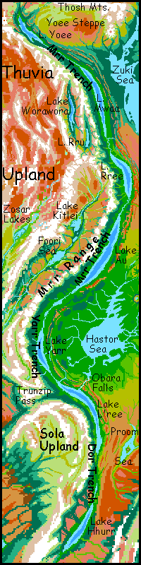
- MRR TRENCH, Mrr Range, 0-67 N, 50-75 E---A biological hotspot east of Thuvia, Mrr Trench is the longest on Tharn, though below the sharp equatorial bend at Lake Yarr, it's called Dor Trench. The complex is fully 10,000 km long (6,250 mi) and ranges from 3-6 km deep (10-20,000'). Long lakes dot the trench floor, of course. A western spur of the trench creates the Worawora Basin. The Mrr Mountains separate Worawora from the main trench; their spectacular eastern face is up to 10 km tall (33,000'). (source: lebbird name)
- Muptip Range, 60-75 N, 150-180 W---a low but icy northern range running for 2000 km (1250 mi) between the Raksar and Ozara Seas. The Muptips rise up to 2500 m (8,250'). Nomadic mamooks graze the slopes in summer, but no one lives here. (source: mamook name)
- Lake Murra (moor-ah, not mrr-ah), 18 S, 100 E---a lake 600 km long (375 mi) deep in the southern end of Yoof Trench, just west of the P'tarth Range. Lake Murra is 3.5 km down, with air thick enough for large fliers like heat-adapted lebbirds and flyotes; it's also home to flightless lobbras and veltaurs. Its latitude and depth make Murra's climate hot and rather dry except right by the lake; irrigation is the norm. The west side of the trench drops abruptly, in spectacular cliffs. Murra is the southeast end of the lebbirds' range; they'd thrive in Dupdup Trench to the east, but it's a wingless walk nearly 3000 km long (1800 mi). For such a well-known place, Murra's longitude is hotly debated; caravan maps put Murra at 110 east, orbital photos at 95 (our world map favors local cartography since the photos aren't easy to interpret). Errors are understandable; no one heads due east or west from the lake over the cliffs, mountains and deserts--all (sane) traffic follows the trench. (source: lebbird name)
- LAKE MWAA, 37-53 N, 70 E---a lake 1100 km (690 mi) long in Mrr Trench east of Thuvia. Lying in a rainy zone, this stretch of the trench has filled more than most; the lake-face is only 2.8 km below datum. Mwaa is freshwater, for it drains north into deeper Lake Yoee. Its shores are fertile and densely wooded; largely lebbird orchards. (source: lebbird name)
N -- jump to A - B - C - D - E - F - G - H - I - J - K - L - M - N - O - P - R - S - T - U - V - W - Y - Z - Names - Sounds
- Lake Neira, 3 N, 148 E---largest lake in Aihu Basin, on the southeast rim of Dejah Upland. Lake Neira straddles the equator and lies about two km high (6600'); the surrounding hills look a bit Mediterranean, and even more like the Ethiopian highlands. Centahs herd the hills; camaroos and veltaurs farm the valleys. Neira's warm for camaroos and cold for veltaurs, right at the edge of their respective ranges; one of very few places they cohabit. (source: veltaur name)
- Nesh Ru Lake, River and Falls, 10 N, 150 W---L-shaped Lake Nesh Ru is the largest lake in Thoris Upland; it lies 3.3 km above datum (11,000') on one of Thoris's southwestern terraces. Nesh Ru is 200 km long and up to 50 wide (130 by 30 mi). Its icy waters are the source of Nesh Ru Falls, 500 m high and 1000 wide. The Nesh Ru River collects most of the runoff from southwestern Thoris, running 800 km (500 mi) southwest to the Kaol Sea. Above the falls, the Nesh Ru Basin is a mild subalpine highland; camaroos dominate. Below, veltaurs and centahs and lobbras herd and farm. (source: veltaur name)
- NGIPPO RIVER, 20-45 S, 140-170 E---a river 3200 km long (2000 mi), probably the longest on Tharn. The Ngippo collects most of the runoff from the south side of the huge Chinchak Range. Its valley cuts across the Tin Kik Desert, creating a long irrigable strip much like the Nile. (source: lobbra name)
- Noor Nar Crater, 18 S, 70 E--- an impact crater 25 km across (15 mi) near Zor Rift. It's a fresh rugged scar only about 10 million years old, with a ringwall still nearly a kilometer high--high enough to catch rain and sustain forests. The floor is a round lake, one of the few in the region; small streams radiate out from the debris apron. Noor Nar Crater is just one of a long chain (see Zu, Shif Shif, Hiffa, Shira and Washi Craters). The surrounding prairie is generally called Noor Nar Veldt. (source: veltaur name)
- NOOR NAR VELDT, 10-20 S, 60-80 E---A savanna east of Sola Upland, north of the Proom Desert and south of Invak Wood and the Hastor Sea. Noor Nar is a rolling plain of about 600,000 sq km (250,000 sq mi), green in winter, gold in summer, inhabited by a mixture of veltaurs, centahs and flyotes. The only hills are the walls and rays of Noor Nar Crater (see above), and the ridges of Zor Chasma to the east. (source: veltaur name)
- Notan Hills, 11-16 S, 125-130 E---A range of equatorial hills rising east of the Felatheen Sea, south of Dejah Upland and northwest of the Chinchak Range. The hills, nowhere over 2.5 km high (8000') are an ecological island of brush and open woods on the broad Felatheen Veldt. (source: E.R. Burroughs)
O -- jump to A - B - C - D - E - F - G - H - I - J - K - L - M - N - O - P - R - S - T - U - V - W - Y - Z - Names - Sounds
- Obara Falls, 16 S, 63 E (longitude doubtful, from caravan maps; orbital photos suggest 59 E)---a set of cataracts on the Hastor River, draining the sea of that name down into Lake L'ree in Dor Trench. There are over a dozen major falls, many of them spectacular, for the river drops 3.3 km (11,000') in 65 km (40 mi), and the flow is many times larger than Niagara, for the Hastor Basin is rainforest. If Lake L'ree wasn't in a dry, sunny high-evaporation zone, the trench would fill, destroying the falls and creating a birdsea. (source: bo name)
- Obbelak Crater, 25 N, 170 W---Obbelak is a flawlessly preserved impact basin 60 km wide (35 mi) in the Liklik Desert. The rim is low, only 300 meters high (1000'). But that's the highest thing for hundreds of km. Rays of debris run from the rim 160 km in all directions. (source: flyote name)
- Obilla River, 1-16 N, 55-65 W---A winding, many-branched river about 1000 km long in central Barsoom, draining the western Madhu Hills and Esharee Veldt to the north. The Esharee branches run parallel along the floors of fossae caused by crust bending down into Shuka Trench. The southern Madhu arms all meander through rainforest. (source: bo name)
- OHHH FOREST, 20-35 N, 170-180 E---Ohhh (a deep croaking groan with a falling pitch) is a temperate forest west of the Sea of P'tang. Ohhh is about 720 km (450 mi) long, sweeping up from the shore to the rugged Alpine basins of the Artolian Chaos, 500 km inland (300 mi). The Ohhh Forest was settled and named by elaffes, a huge, slow, giraffish people of the northern woods. But Ohhh is warm enough for a large minority of mops and even a few lobbras. (source: elaffe name)
- OKAR TRENCH, 18-40 N, 35-40 W---the trench east of Llana Upland, in the northern Barsoom Basin. Relatively dry, Okar plunges as deep as 6 km; two small lakes fill only the very lowest spots. Due to the depth, the climate's hot, despite the latitude, and the air is dense and easy to fly in. Trench wingbok dominate here, though thotters live along the lakeshores. (source: E.R. Burroughs)
- Ombra Crater, 57 N, 135 W (world map has 125, but longitudes this far north are hazy--caravan maps range from 125 to 140!)---An impact crater north of the Raksar Sea, Ombra is one of Tharn's largest and ruggedest: 190 km wide (120 mi). A cool lake fills the floor, 1 km below the plains outside and 3 km (10,000') below a ringwall snowcapped even in summer. It's a little world of its own, sheltered from the polar winds; the inner north rim, tilted toward the sun to the south, feels almost temperate; the northernmost flyotes on Tharn live here, taking advantage of the denser air. They form a hybrid culture with thotters, mops and camaroos living round the lake. Outside, Ombra's splash apron distorts Raksar into a U shape, and rays of debris form straight, radial capes and "fjords" along Raksar's north shore, 160-250 km long (100-150 mi). Mops dominate these wind-sheltered woods. (source: E.R. Burroughs)
- Omchatta River, Lake Omchatta, 15 N to 12 S, 135-120 E---Lake Omchatta is a triangular sheet of fresh water 330 km (210 mi) long and nearly 4 km high (13,000'), in central Dejah Upland west of the Koom Sea. The Omchatta River, 3200 km (2000 mi) long, winds southwest from the lake through broad alpine meadows for a few hundred km, then slices a deep, straight canyon out of the uplands down to the Felatheen Sea. (source: thotter name)
- Omp Mts, 10 N, 125-130 W---a volcanic range between Thoris Upland and the Thurian Rift, south of the Tunol Marshes. The Omps are small in extent but fairly high, with three twin-peaked volcanoes 5-6 km high (16-20,000')--comparable to Ararat, Denali, or Kilimanjaro. The Omps resemble the peaks of the Tars Triangle just across Thurian Rift; both ranges seem to be the result of compression. (source: E.R. Burroughs)
- Ondronka Basin, 62-75 N, 80-150 E---a far northern tundra basin. The sinuous Ondronka River flows east in summer, (most of the year, nothing here flows anywhere!) collecting milky water from many tributaries off the tundra and the ice cap to the north. It cuts through the Gomlap Hills, then winds southeast to Lake Ondronka, a brackish little sea 200 km long and half as wide (125 by 60 mi) (source: mamook name)
- Lake Oonira, 47-50 S, 45 W---Lake Oonira, 320 km long but only 65 wide (200 by 40 mi) is a brackish, alkaline riftlake with no outlet, lying in southern Wula Rift. Snowy ridges surround the lake; its shores are dry grassy steppes. Like Lake Wssh to the north, Oonira has hotsprings feeding tufa reefs and towers, with strange life reminiscent of our deep-sea vent communities. (source: veltaur name)
- Oosh Tundra, 60-70 S, 40 E to 40 W---a cold windy steppe south of the Ugor and Anthor Seas, running down to the polar cap. The northern edge sustains grass, but the south is just rocks and lichen; it's frozen most of the year. Only nomadic mamooks live here. (source: mamook name)
- OROVAR RANGE, 32-70 N, 75-105 W (longitudes approximate; it's far north and little visited)---a chain of huge shield volcanoes south of Raksar Sea and west of Llana Upland. High point: Mt Gholit, 16 km high (50,000'). Crust spreading from the Kantol Rift is evidently sweeping over a large stable hotspot here. The Orovars, being subpolar, are heavily glaciated barrens, unlike other shield-volcano chains on Tharn, like Jahar and Chinchak. (source: E.R. Burroughs)
- OTZ TRENCH, 10 S to 48 N, 25 E to 30 W---the main trench west of Thuvia Upland. The straightest, most prominent, and one of the longest on Tharn--a good 5000 km (3000 mi). The north end breaks up into three arc-basins, Tlikki, Roop and Hai Lek. Only Roop has dense enough air for fliers like trench wingbok. But down in the main trench, Lakes Hinla, Teina and Foosh have major wingbok civilizations with small lebbird minorities; only a few lebbirds have made it here over Trunzip Pass. Flyotes, of course, are everywhere. (source: E.R. Burroughs)
- Ozara Sea, 55-60 N, 180 W---a far northern sea 800 km long (500 mi), lying in a tundra basin just north of Kantol Rift, west of Ulvas Crater and Raksar Sea. From orbit Ozara looks like a (badly drawn) dead bluebird. It's choked with low, silty islands. The only inhabitants are mamooks. Site of a great annual song-duel festival or "chong-ma". (source: E.R. Burroughs)
P -- jump to A - B - C - D - E - F - G - H - I - J - K - L - M - N - O - P - R - S - T - U - V - W - Y - Z - Names - Sounds
- Palrak Lakes, 20-28 S, 30 E---Four shallow, slightly brackish lakes just east of Heloon Crater. The shores are dry veldt, the edge of the Heloon Desert to the south. Their source is snowmelt from the Lothar Mts (the outer ring-range of Heloon), and from the Molak and Trunzip Ranges to the east. Centahs water their herds here, but the marshy shorelines flood and recede seasonally; too variable for permanent settlement. (source: centah name)
- PARTHAK CRATER, 15-20 N, 105 E---the second largest impact scar on Tharn, Parthak lies west of Dejah Upland. Parthak is fully 300 km (190 mi) rim to rim, with a splash apron and rays spreading 1000 km in all directions. It's fairly fresh: 30-50 million years old, it lies in a dry zone where weathering is slow. Parts of the ring are still 5 km high, and bear small glaciers. A lake fills the crater; the central peak is now an island. (source: E.R. Burroughs)
- P'DROMA DESERT, 55-70 N, 0-40 W---a near-Martian desert the size of Patagonia. P'droma is a stony red plain in summer and a white waste in winter. It's a broad saddle from 1-2 km above datum, between Gahan Tundra and the Umka Sea, north of Roop Basin. (source: mamook name)
- Lake P'koon, 12 S, 4-12 W---a brackish sea 640 km long (400 mi) in Heloon Crater. Lake P'koon fills the northwest end of the Tor Kvas Valley, between the Ksana and Lothar Ranges (the inner and outer ringwalls). P'koon lies fully 5 km down; the dense air, heat, and moderate rainfall make the region a lush breadbasket (egg- and fruit-basket really). Thotters fish the shores; lebbirds and flyotes (attracted by the dense air) tend orchards and beanfields around it; further from the shores, in open prairies, wingbok graze and centahs herd losha. To the east lies similiar Lake Shath. (source: centah name)
- Podraap River, 25-32 S, 150-168 W---A shallow, stony river running 1600 km (2000 mi) west from Thurian Rift to the Zodanga Sea. The region is otherwise rather dry; most locals are mops and thotters living along the river, as in the similar Gerpook Valley to the south. (source: mop name)
- POLODONA WOOD, 8 N to 8 S, 150 W to 165 E---a great equatorial forest west of the Kaol Sea and east of Dejah Upland. Polodona's edges fade into open woods, groves and savanna, so its area is hard to pin down, but it's at least 1.25 M sq km (500,000 sq mi). (source: E.R. Burroughs)
- Pong River and Lake Pong, 18-25 S, 170-180 W---The Pong is a shallow, gravelly river 900 km long (550 mi), rising on the dry south side of the Chinchak Mountains and running south through the Tin Kik Desert to the west shore of marshy Lake Pong, a rough triangle of shallow water 330 km (210 mi) long, which drains into Gedda Bay on the Zodanga Sea, just to the south. (source: lobbra name)
- Lake P'p'p (a bilabial farting noise like a Bronx cheer), 46 N, 135-140 E---Lake P'p'p, 190 km long and 40 wide (120 by 25 mi) is a lake in Yoof Trench just south of far larger Lake Rrao. Both lakes are snowmelt and lie at nearly the same depth (over 3 km down), but the P'p'p Valley is much colder than the shores of Rrao, for the Yoof Range looms 8-10 km over the lake's south side, shading it much of the year. Here, elaffes first bred the frost-hardy fruit trees they later planted all over Rronk Wood--indeed, much of northern Tharn. (source: elaffe name)
- Proom Desert, 20-50 S, 70-90 W---A desert plain east of Sola Upland, between Dor Trench and Zor Chasma; the north end fades into Noor Nar Veldt, the south end into Iss Tundra. The Proom Sea is the only significant oasis. (source: centah name)
- Proom Sea, 22-29 S, 75 E (disputed: claims range from 70-80 E)---A desert bed-lake 600 km long (380 mi) east of Sola Upland, between Dor Trench and Zor Chasma. A long, shallow, salty lozenge of a lake with one large central island, Kindasharo, which is the debris apron around Washi Crater. The climate is Mediterranean, mild but dry, with trees only along streambeds and on Washi's ringwall; the shores are grassy--the southern edge of Noor Nar Veldt. Beyond is only the Proom Desert. (source: centah name)
- Pshika Is., 20 N, 105 W---an archipelago of Mediterranean islands in the northern Rippagong Sea. Pshika proper, twice the size of all the others combined, is a great wedge of rolling meadows and groves, 220 km long (130 mi). (source: thotter name)
- Lake Pshu, 1-6 N, 22 W---A triangular lake 250 by 160 km (150 by 100 mi), just south of the Waroon Sea in Barsoom Basin. The shores are tall tropical forest. The swampy Isle of Pshu, 80 km/50 mi wide, nearly fills the south end of the lake. Thotter fishing-villages line these shores. (source: thotter name)
- Psop Peninsula, Lake Psop, 41-44 N, 90 E? (disputed)---a broad, densely wooded cape on the east shore of Zuki Sea, shaped like a dented bowl with narrow, marshy Lake Psop in its center. To the north is sinuous Insoralta Sound, to the south, Manlat Arm and Lake Rondzin. Mudbanks and kelp beds make for rich fishing and "clamming" for the local thotters. (source: thotter name)
- SEA OF P'TANG, 20-34 N, 180 E---P'tang is a triangular sea 1500 km (900 mi) long, west of Thoris Upland and east of the Artolian Chaos. The straighter western shore is open woods and chaparral; the east is grassier, and broken with islands, bays, and marshy satellite lakes; here the basin ends abruptly, in cliffs rising to a dry lava plateau: the Liklik Desert. (source: E.R. Burroughs: Ptang)
- P'TARTH MTS, Lake P'tarth, 10-30 S, 105-115 E (disputed; may be as little as 95-105 E)---the south end of Dejah Upland, splitting into a forked tail. Narrow Lake P'tarth, 450 km long, lies between the east and west ranges. Despite its shape and depth, locals don't consider it a true trenchlake, for it lies only 1.3 km (4500') below bedlevel; the air's too thin and dry for a full trench ecology, though large, big-brained flyotes do live here. But Lake Murra, just to the west, is the real thing: nestled deep in Yoof Trench, it supports lebbirds and fullsized trench wingbok.(source: E.R. Burroughs: Ptarth).
R -- jump to A - B - C - D - E - F - G - H - I - J - K - L - M - N - O - P - R - S - T - U - V - W - Y - Z - Names - Sounds
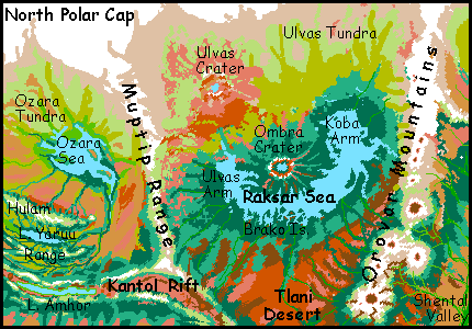
- RAKSAR SEA, 48-62 N, 95-140 W---a U-shaped northern sea nearly 2000 km long (1200 mi), lying north of the Orovar Range and Kantol Rift. A broad peninsula, the center of the U, is the splash apron of Ombra Crater to the north. Its rays of debris form straight, radial capes and "fjords" along the north shore, 160-250 km long (100-150 mi). These wind-sheltered valleys are densely wooded and home to large populations of mops. (source: E.R. Burroughs: Raxar)
- Rani Hu River, 10-20 N, 95-100 E---A river watering Shen Veldt northeast of the Varo Sea. Its main source is Rani Hu Lake, a mountain lake 50 km (30 mi) long in the southwestern ranges around Parthak Crater, but other branches drain the valleys between several rays (debris ridges from the crater). The Rani Hu flows southeast to Lake Shen, then the Varo Sea and ultimately into Lake Murra in Yoof Trench, about 3200 km south (2000 mi); with the Shen RiverM to the west, it forms the second longest river system on Tharn. (source: veltaur name)
- Rapass Crater, 46-48 N, 110 E---an impact crater 200 km (125 mi) across, between the Duhor and Wolak Seas, northwest of Dejah Upland. It's so far north, the shady north faces of both rims have glaciers; a cold, milky, silty lake 60 km wide (40 mi) fills the center. Dark forest covers the rest of the floor. The sheltered, south-facing inner slopes are warm for this latitude, and are dotted with camaroo and mop villages. (source: E.R. Burroughs)
- Repseen Maze, 13-24 N, 75-85 W---The north end of the Kantol Sea in Barsoom. Repseen is a labyrinth of sounds and low ridges (some islands, some capes), all trending northwest-southeast. The borders are debatable, but the Maze is about 1300 km long and half as wide (800 by 400 mi). The climate's Mediterranean, with groves on the ridges and trees along river and shores, but brushy hillslopes opening to meadows. Veltaurs, centahs and a few camaroos farm and herd; thotters fish the sounds (and run an extensive ferry system). (source: thotter name)
- Rinnery River, 20 S, 135-120 E---the Rinnery flows west from the Chinchak Range to the Felatheen Sea. Fully half the population of southern Felatheen Veldt lives along the Rinnery--its snowmelt is the only reliable clean water in the region. (source: veltaur name)
- RIPPAGONG SEA, 14-24 N, 100-110 W---a triangular sea in the western Barsoom Basin, northwest of K'lantha Veldt and the Kantol Sea, south of the Orovar Range. The climate's warm, the flora rather Mediterranean; thotters, veltaurs and centahs are common. Though shallow, the southern half of Rippagong is fairly unbroken; the Pshika Islands dot the north. Rippagong's 950 km long and 640 wide (590 by 400 mi). (source: centah name)
- Lake Rishish, 24-29 S, 60-65 W---Lake Rishish, 550 km long but never more than 65 wide (330 by 40 mi) lies in the bottom of Wula Rift. It's a classic riftlake--brackish, mineralized, with grotesque tufa towers and pyramids on its shore and in its depths, where hot vents feed strange life forms and thermophilic bacteria stain the lake with bloody purple clots. Over the rift zone's ridges to the east lies the fertile Wula Sea, but the shores of Rishish, cut off from rain, are red desert; the lake's fed only by runoff from the ridges above. Rishish has a non-identical twin to the south: Lake Wssh. (source: veltaur name)
- Rondzin Steppe, 35-50 N, 90-100 W---a temperate prairie west of Zor Chasma and east of the Zuki Sea and its satellite Lake Rondzin. It's much the size and climate of the Dakotas--about 400 by 1200 km (250 by 750 mi). camaroos graze flocks in summer, but there are few year-round residents. (source: thotter name)
- Lake Rondzin, 40-43 N, 90? E (longitude disputed: 82-94!)---a lake southeast of the Zuki Sea. Rondzin is 160 by 320 km (100 by 200 mi). To the west is the heart of dark Zuki Forest, home of elaffes and mops; to the east is the chilly, lonely Rondzin Steppe. Thotters fish the lakeshores. (source: thotter name)
- ROOP BASIN, Lake Roop, Roop Range, 37-54 N, 10-24 W---a large arc-basin on the northwest side of Thuvia Upland; the range dividing it from Thuvia, some 8 km high, is called the Roop Mts. Though north of Hai Lek Basin, Roop Basin's warmer and more fertile, due to its great depth: a spur of Otz Trench runs up its east side. Lakes Yikla and Alinne, down in the spur, average over 3 km below datum, giving them dense air and mild climates for this latitude. They sustain large trench wingbok populations. But shallow Lake Roop, though 500 km (300 mi) wide, lies at the far northern end where the trench trails off. It's only 1.5 km down (only a mile below "sea level"), so most inhabitants are mops, camaroos, and primitive plains wingbok, not the larger, smarter trench variety, who find flight too hard in the thinner air. (source: mop name)
- LAKE RRAO, 45-49 N, 125-145? E (disputed)---Rrao is a lake 1050 km long and 120 wide (650 by 75 miles), with densely forested shores. Though it's nearly 50 degrees north--the northernmost in Yoof Trench--and below the feet of a towering glaciated range, the Rrao Valley's subtropical; winter winds get cold, but snow is rare, for at 3.5 km (11,500') below bedlevel, the trench is an oasis of dense, warm, moist air. Elaffes probably evolved here. The valley's now also colonized by lebbirds; their name for it is commonly used, since the booming elaffe name is unpronounceable by anyone smaller than a truck. A small spur of the trench just south of Rrao holds smaller, colder Lake P'p'p, source of many important tree-crops used across the North. (source: lebbird name)
- Lake Rree, 22-28 N, 75 E (disputed: caravan maps place it anywhere from 65 to 78 east! Understandable, since desert and mountains block east-west travel)---Lake Rree lies deep in Mrr Trench, east of Thuvia Upland. It's a dry zone, so Rree is relatively small, "only" 640 km long (400 mi). With no outlet but evaporation, the water's quite salty. Rree is the lowest lake in Mrr Trench, with the densest air. Though dry, the climate is mild, and irrigated groves line the west shore, fed by snowmelt-streams from the Mrr Range. Lebbirds may have evolved along its shores, though the cultural heartland has shifted to larger Lake Au to the south. (source: lebbird name)
- Lake Rrit, 27-35 S, 120 W---Lake Rrit lies 5.5 km deep in Har Trench, just west of Tarkas Upland. Rrit's 800 km long but only 160 wide (500 by 100 mi). Smaller Lake Jeet lies just north. The shores are mostly irrigated orchards tended by arthom. (source: artho name)
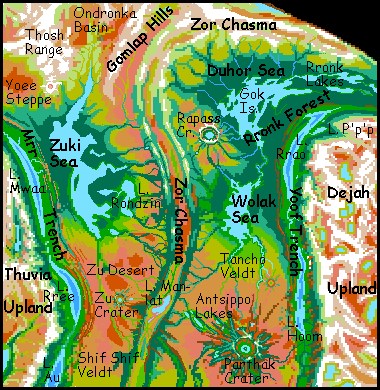
- RRONK FOREST, 33-55 N, 110-165 E---The largest boreal forest on Tharn, below northern Dejah Upland; an elaffe heartland, also settled now by camaroos. This cool evergreen strip runs 7000 km from the Wolak Sea east to the Sea of P'tang. The four Rronk Lakes, 150-250 km long, lie east of the Duhor Sea; the rain they generate extends the east end of Rronk Forest another 1000 km... (source: elaffe name)
- Lake Rru, 35 N, 70 E---a lake 300 km long and 80 wide (200 by 50 mi) in the southeast Worawora Basin, east of Thuvia Upland. The lake lies 1000 meters (3300') below bedlevel. The shores have fertile prairies with occasional wooded streams descending from the Mrr Range just to the east. Thotters fish the shores and centahs herd flocks in the lowlands round the lake, just as camaroos do in the cooler hills above. Still, it's a cultural backwater next to Mrr Trench over the mountains to the east, or even Lake Worawora to the west, fully 2.25 km below bedlevel; its denser air allows lebbirds to fly, and is warm enough for veltaurs. (source: lebbird name)
- Ruha Islands, 12-23 S, 45-50 W---an archipelago turning the eastern Wula Sea (in southern Barsoom) into a maze of channels. The northern Ruhas are a chaos of small, low isles, but the southern Ruhas fuse into twin ridges, each 400 km long (250 mi) but rarely over 50 km wide. All the Ruhas have a Mediterranean climate. Thotters aquafarm the shores in spots, but most inhabitants are veltaurs. The archipelago appears to be broken lava flows from the Jahar Range to the south. (source: veltaur name)
- Ruvallin River, Lake Ruvallin, 2-13 N, 100 E---An equatorial, triangular lake 340 by 160 km (210 by 100 mi), draining west into the nearby Varo Sea. Ruvallin has a monsoon climate, rainy in summer and mild and dry during orbital winter; however, the lake doesn't drop in the dry season, as it's fed by the Ruvallin River from the heights around Parthak Crater to the north, and those ridges get most of their rain in sparse winter storms. The north shore is open woods, but the south has dense growth thickening to rainforest: the east end of Varo Wood. (source: bo name)
S -- jump to A - B - C - D - E - F - G - H - I - J - K - L - M - N - O - P - R - S - T - U - V - W - Y - Z - Names - Sounds
- Shaleen River, 30-45 S, 30-40 W---modest in flow but 1300 km long (700 mi), the Shaleen rises in the forests of Wula Rift. It flows south along the western edge of the Heloon Desert to the Shaleen Sea; its long green lake-dotted valley is a major caravan route from Barsoom Basin to the forest belt of the far south. (source: centah name)
- SHALEEN SEA, 40-50 S, 25-30 W---the only sea protruding into Heloon Desert. The southern shore is wooded, but in the north red cliffs and sand dunes rise right from the water; the only green's the marshy delta of the Lante River. Smallest and saltiest of the three seas south of Heloon, Shaleen is still stabler than many Tharnian seas, for it's fed by rivers from different climate zones. In wetter times, the Shaleen Sea may link with the Ugor and Anthor Seas to the southeast, forming an almost-ocean and making the desert a prairie. (Source: centah name)
- Sharoo Falls, LAKE SHAROO, 20-35 S, 90-105 W---One of the largest cataracts on Tharn: a good-sized river cascades down dozens of falls, from 50 to 200 meters each (160-660'), as the Sharoo River drops from the Gathol Sea level down to Lake Sharoo, deep in Chanath Trench. Lake Sharoo itself is huge, 1900 km long and up to 250 wide (1200 by 150 mi). It drains south to Lake Yoseno, even deeper in the trench. The lake is a haven for a unique subspecies of trench wingbok. (source: E.R. Burroughs: Sharu).
- Lake Shath, 12 S, 0-5 E---a lake 560 km long (350 mi) in Heloon Crater. Shath lies in the northern Tor Kvas Valley, between the Ksana and Lothar Ranges (the inner and outer ringwalls). To the west lies similar Lake P'koon; to the south, Lake Tholna. (source: centah name)
- SHEN VELDT, Lake Shen, Shen River, 7-20 N, 90-105 E--- Shen Veldt is a triangular plain 1500 km wide, east of Zor Chasma, southwest of Parthak Crater, and north of the Varo Sea. A warm savanna dotted veined with creeks and dotted with groves, especially in the south, where the trees thicken into Varo Wood. Lake Shen, 270 km long and up to 60 wide (170 by 35 mi), is a shallow, segmented lake (shaped like the body of an ant) in the south-central veldt, fed mainly by two rivers rising in the radial Parthak ranges: the Shen to the northwest and the Rani Hu to the southeast. (source: veltaur name)
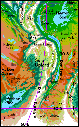
- Shental River and Valley, 30-45 N, 80-90 W---A semiarid valley just east of the Orovar Range in Barsoom Basin. Streams flowing southeast out of the mountains collect into the Shental River, flowing 1000 km southwest to Lake Thimret, then on through greener prairies to the Rippagong Sea. Above Thimret, the valley looks like Nevada: piny heights, scrub and dry grass on the valley floor, green veins of broadleaf trees along the rivers. Though the lavender sky gives it away...(source: centah name)
- Shif Shif Crater, 11 N, 70 E (disputed; caravan maps put it at 75-80 E)---An impact crater 70 km wide (45 mi) in the veldt west of Zor Chasma, north of Invak Forest and the Hastor Sea. This savanna's often called Shif Shif Veldt. The impact must have been recent; this close to Zor Rift, the crust is no more than 12 million years old. Shif Shif's just one of a chain, probably all formed together from the impact of a comet train like Shoemaker-Levy. Shira Crater to the south is a near-identical twin; Zu, to the north, is larger still; lesser craters pepper the whole zone from 25 south to 30 north. (source: veltaur name)
- Lake Shillim, 20-23 S, 4-9 E---a brackish, oval lake 290 km across (180 mi) in Heloon Crater. Lake Shillim lies in the southeastern Tor Kvas Valley, between the Ksana and Lothar Ranges (the inner and outer ringwalls). To the north lies similar Lake Tholna; to the southwest, Lake Kwaree. (source: centah name)
- Shinnif River, Falls, Marsh, 18-24 N, 150-175 W---The largest river crossing the Liklik Desert. The Shinnif flows 2200 km (1350 mi) west from the Thoris Upland; it drops from plateau to plateau, and the last drop to the desert plain is a wide, spectacular fall 200 m high--four times Niagara! The lower Shinnif is a green strip forming the south border of the Liklik Desert; the plain is merely semiarid veldt to the south. Near its outlet on the Sea of P'tang, the river slows and spreads into Shinnif Marsh. (source: veltaur name)
- Shira Crater, 0 N, 70 E (disputed; caravan maps show 75-80 E)---An impact crater 80 km wide (50 mi) west of Zor Chasma, in Invak Forest near the Hastor Sea. Its flooded floor is called Lake Shira. Rays of ejected rock from Shira shirr the shore (sorry, I couldn't resist) of the Hastor Sea, forming regular capes and bays for several hundred km. Such radial ridges are less visible smothered in the Invak jungle, but they extend hundreds of km in every direction from the crater. And Shira's just one of a chain of craters (probably) formed together from the impact of a comet train like Shoemaker-Levy. The impacts must be recent, as the crust here so close to Zor Rift is only 12 million years old. Shif Shif Crater, 850 km north, is a near-perfect twin; Zu Crater beyond it is larger; and lesser craters pepper the whole zone from 25 south to 30 north. (source: veltaur name)
- SHUKA TRENCH, Lake Shuka, 18-36 N, 50-75 W---the subduction trench southwest of Llana Upland; the northern border of Barsoom Basin. The shores of Lake Shuka, 4 km below datum, hot, rather dry, but with many streams descending from the Upland, harbor an isolated trench wingbok civilization. (source: centah name)
- Shunai Bay, 16-21 S, 95-105 W---The western third of the Gathol Sea, Shunai Bay is 800 km long and 500 wide (500 by 300 mi), split into eastern and western halves by Cape Aroba. The rich Shunai coast is home to bos, veltaurs, centahs, thotters, flyotes and wingbok. (source: veltaur name)
- SOLA UPLAND, 20-60 S, 40-70 E---a southern highland over half the size of Australia. Sola rises south of much larger Thuvia Upland; the Yarr Mtns link them. Sola has a quite Andean "coastal range" on its east side, rising to 8 km high (27,000'), then dropping 10-15 km (33-50,000') into Dor Trench. But to the west, its plateau angles gradually down for 2000 km through subalpine meadows, forest, and chaparral, ending at last in the Heloon Desert. (source: E.R. Burroughs)
- Lake Ssa, 12-14 N, 0 E--- A freshwater lake 250 km long (160 mi) in Yoof Trench, 4.5 km below the plains, draining north into Lake Arroo and then huge Lake Hoom. The valley floor is hot, but not as arid as the lakes to the north: the north end is savanna away from the water, and tall "monsoon" forest covers the south shore. Lebbirds irrigate orchards here, and thotters fish the lake. (source: lebbird name)
T -- jump to A - B - C - D - E - F - G - H - I - J - K - L - M - N - O - P - R - S - T - U - V - W - Y - Z - Names - Sounds
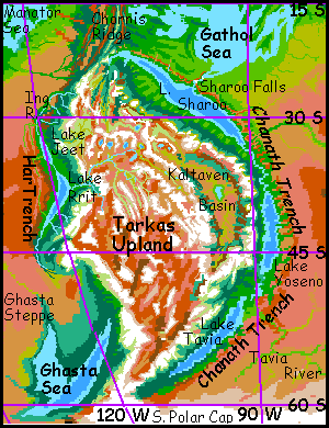
- Talaya River, 23-33 N, 150-175 W---the Talaya flows 1500 km from Thoris Upland west to the Sea of P'tang. The Talaya rises from snowy dorsae (long, straight compression ridges) in north-central Thoris, winds west through alpine meadows, drops to a "terrace" hundreds of km wide, dotted with "scrub oak" and "pine", where it collects the runoff from much of western Thoris, then pours 200 meters (660') in a broad fall down into Talaya Canyon and crosses the Liklik Desert. It's one of only three year-round streams there; its canyon is an oasis farmed by flyotes and lobbras. (source: wingbok name)
- Tancho Veldt, Tancho Crater, 20-30 N, 110 E---Tancho Veldt is a warm dry-grass plain east of Zor Chasma, south of the Wolak Sea. Tancho Crater is its most prominent feature--an impact basin 60 km (40 mi) across, with walls a mile high (1.5 km), high enough to sustain woods on its the rim. But the ridge diverts rain from the crater floor; it's savanna and marsh, with few trees. Large flyotes are the main residents. (source: centah name)
- TARKAS UPLAND, 15-65 S, 90-120 W---the largest southern highland, about the size of Australia. Tarkas lies west of Chanath Trench, south of the Tars Triangle, and east of Har Trench and the Ghasta Sea. On its northeast edge, is Kaltaven Basin, a grassy Mongolian steppe 1200 km long and 400 wide. On the east side the Kaltaven Range rise 5 km (16,000') to a height of 7 km (23,000') above datum; their east face drops over 12 km (40,000') into the Chanath Trench. The southwest front range, above the Ghasta Trench, is just as high though not quite as spectacular, since Ghasta is flooded up to datum. (source: E.R. Burroughs: Tars Tarkas).
- TARS TRIANGLE, 15 N to 15 S, 100-120 W---a fractured wedge of land between the Wula and Thurian Rifts, north of Tarkas Upland. From the upland, a great dorsa (compression ridge) stretches north: Chornis Ridge. From its tip radiates a fan of long ridges, the Manacha Fan; beyond, in the wedge where the two rifts meet, tall stratovolcanoes rise, each a multispecies city-state. Four rival Kilimanjaro or Denali: Akor, Ethas, Ikos, and Imal. (source: E.R. Burroughs: Tars Tarkas).
- Tavia Tundra and Lake Tavia, 55-70 S, 60-120 W---south of the Bantoom Sea, the Tavia River drains a tundra basin bigger than Alaska. The river cuts a canyon down to Lake Tavia, a deep, cold, fresh, leaf-shaped lake 640 km long (400 mi) on the floor of Chanath Trench.
- Lake Tebbik, 2-4 N, 32 E---Cupped in dense forest, Lake Tebbik moderates the climate of the lower Zozar Valley; though it's 3.5 km up (11,500'), it's sheltered and not far from the equator. The lake is oval, 55 by 160 km (35 by 100 mi), and milky with glacial silt from the great peaks rising another 3-4 km on all sides. Tebbik is freshwater; a deep slash of a canyon cuts drains the lake southwest to the tiny Bundaroo Sea. (source: mop name)
- Lake Teina, 17-27 N, 0-15 W---A lake 950 km (600 mi) long, lying in Otz Trench, from 15-25 north. Fully 5 km below datum, with dense air and fertile shores, it's a center of trench wingbok civilization. (source: wingbok name)
- the Terraces (or the Jahar Terraces), 10-22 S, 25-35 W---Scalloped, cliffwalled, overlapping lava plateaus, like the wax at the base of a candle, on the west slope of the Jahar Range. Each terrace has a different altitude, climate and dominant species. Snowmelt from the great volcanoes collects into large winding rivers on these plateaus, then plunges in large falls to the lower levels. Similar lava flows create similar falls on the north side of the Chinchak Range, a region called the Ksaksa Stairs. (source: descriptive trade-camaroo name)
- Mt Thagh, Thagh River, 10 S, 165 E---Mt Thagh is a shield volcano 15 km (50,000') high, in the central Chinchak Mountains. Source of the Thagh River, which drops over lava terraces in spectacular falls on its way to the Ksaksa Sea at the mountains' feet. Such terraces on Thagh's flanks form a set of ecological sky-islands, sustaining half a dozen peoples in close proximity. The only inhabitants of the peak itself are mamooks. (source: mamook name)
- THARK SEA, 39-50 S, 105-130 E---a southern sea northeast of Zor Chasma, south of the Tin Kik Desert and west of the Zodanga Sea. Thark is big---1500 km long and up to 320 wide (950 by 200 mi). The shores look Nordic--cool, dark evergreen forests. In wetter eras a strait links Thark and Zodanga; now and then they merge entirely, into a true ocean. (source: E.R. Burroughs)
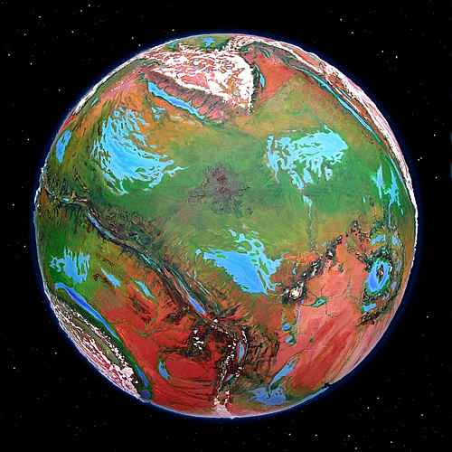
- THARN---a large moon, diameter 8300 km (5200 mi), resembling a tectonically and ecologically living Mars. Gravity 0.59 G; air pressure at datum 0.24 atmospheres, but up to 0.5 in deep trenches and craters. Dry, with 0.2% of Earth's water; land area 1.25 times Earth's. 13 intelligent species. (source: Richard Adams, Watership Down: a rabbit word meaning "forlorn")
- Thas Crater and Thas River, 10 N, 170 W---Thas is an impact crater 200 km (125 mi) across on a wide veldt plain north of Polodona Forest. It's an old crater: the floor's only 1.5 km below the veldt, and the walls are mere wooded hills. A comma-shaped lake fills half the crater floor. Most locals are large flyotes (attracted by the denser air), lobbras (ditto), and centahs. Creeks radiate from the debris apron, heading west to Lake Chepsillo and southeast to the Kaol Sea; the latter collect into the Thas River, 800 km (500 mi) long. (source: E.R. Burroughs)
- Lake Thimret, 28-32 N, 85 W (disputed; caravan maps have 88-93 W)---an oval bedlake at the south end of semi-arid Shental Valley, between the Orovar Mts and Llana Upland. Thimret is 250 km long and half as wide (150 by 80 mi). Fed by the Shental River, Thimret drains south into the Rippagong Sea. (source: centah name)
- Thioma Maze, 3-18 N, 90 W---A labyrinth of channels centered on Cape Thioma, in the southwestern Kantol Sea. Many-branched Cape Thioma zigzags 400 km into the sea; related islands and sounds stretch a good thousand km along the shore. The warm climate supports open forest with some Mediterranean meadows and aromatic brushy slopes. (source: thotter name)
- Tholemaat River, Lake Tholemaat, 15 S to 2 N, 18-33 W---the Tholemaat rises in the Jahar Range in eastern Barsoom, flowing north, a wooded ribbon across a savanna plain, to Lake Tholemaat, 250 by 160 km (150 by 100 mi). The lake drains north into the marshy west end of the Waroon Sea; its shores are tropical forest. Thotter villages line the river, trading extensively with savanna dwellers like centahs. (source: thotter name)
- Lake Tholna, 15-18 S, 10 E---a narrow lake 460 km long (280 mi) in Heloon Crater. Lake Tholna lies in the eastern Tor Kvas Valley, between the Ksana and Lothar Ranges (the inner and outer ringwalls). To the north lies similiar Lake Shath; to the south, Lake Shillim. (source: centah name)
- THORIS UPLAND, 13-40 N, 135-160 W---Thoris, about 4 million sq km (1.5M sq mi), is the lowest of the northern uplands, much of it a mere 3-4 km above bedlevel, and lacking the abrupt "continental shelf" and "coastal ranges" of the other large uplands. It resembles an irregular pyramid of slabs, each a plateau of a different height, capped by straight, intersecting snowy ridges (dorsae), with an arc of volcanoes at its feet. Thoris's strange ridges seem to be a grander version of the compression fan seen just to the southeast in Tars Triangle. Thoris is west of Kantol Rift and east of the Sea of P'tang. (source: E.R. Burroughs: Dejah Thoris).
- Thoris Veldt, 5-12 N, 140-170 W---a warm grassy plain south of Thoris Upland and north of Polodona Rainforest, stretching 2000 km (1300 mi) from Thas Crater to Lake Guli. (source: E.R. Burroughs: Dejah Thoris).
- Thosh Arm, 51-57 N, 90-95 E (disputed: caravan maps have as low as 80 E. The region is so far north, ten degrees is only 400 km/250 mi)---The northernmost arm of the Zuki Sea, below the Thosh Range. The shores are windy, treeless steppes--the only unwooded shores around the Zuki. (source: mamook name)
- Thosh Range, Thosh Tundra, 58-70 N, 50-90 E (or 45-80 E; polar latitudes are uncertain)---An icy range north of the Zuki Sea and Zor Chasma; a tongue of the North Polar Cap. Peaks rise 2-3 km (6600-10,000'). North of it lies Thosh Tundra, a hilly region of winding shallow rivers frozen most of the year. They've cut sinuous canyons into the ice cap. (source: mamook name)
- THURIAN RIFT, 18 N to 68 S, 115 W to 135 E---a long rift zone west of Tarkas Upland, curving southeast from the Tars Triangle south of the Zodanga Sea to the edge of the south polar cap, then north again as Zor Chasma. Thurian has sinuous twin ridges 2-3 km high (70-10,000') flanking a central rift where new crust is spreading. Many small volcanoes, mud-vents, geyser fields, but fewer mineral lakes than other rifts. (source: E.R. Burroughs)
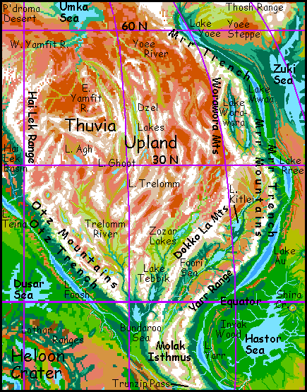
- THUVIA UPLAND, 0-60 N, 0-70 E---the largest upland on Tharn, around 12 million sq km (5M sq mi), nearly twice the size of Australia. Mamooks may have evolved here; they certainly spread to the southern hemisphere via the Yarr Range between Thuvia and Sola Upland. (source: E.R. Burroughs)
- Ti Tip Sea, 25 S, 130 E---Ti Tip is a shallow lake varying from 2-400 km long. It drains much of the western Tin Kik Desert. Marshy, muddy, brackish and slightly alkaline, prone to both flood and drought, it's mainly a watering hole for nomadic centah herders in orbital summer, when other sources in the desert dry up. The only year-round residents are fifty billion flies. (source: lobbra name)
- TIN KIK DESERT and Veldt, 20-40 S, 105-180 E---a huge dry plain southwest of the Chinchak Mountains. Rains are sporadic and unreliable; most residents are lobbras farming the floodplain of the Ngippo River, whose source is Chinchak snowmelt. (source: lobbra name)
- Ting Kom Bay, 39-45 S, 155-160 E---the southeast end of the Zodanga Sea, Ting Kom is an oval bay some 580 km (360 mi) long and half as wide. Thotter villages line the low shores; inland is dense evergreen forest. During Dry Ages, Ting Kom's a separate lake. (source: lobbra name)
- Tintei River, Tintei Valley, 4 N to 10 S, 90-110 W---The largest river feeding the Gathol Sea. Tinteis's source is near the equator in Tars Triangle; its many forks flow 1400 km (875 mi) south through groves and meadows to Shunai Bay, Gathol's west end. The watershed's heavily settled by veltaurs and centahs, with some thotters along the riverbanks. (source: wingbok name)
- Lake Tith, 39-43 S, 85 E---a narrow rift lake 320 km (200 mi) long, in southern Zor Chasma. Lake Tith is salty and mineralized by hotsprings in its depths, and is home to a unique fauna. Bacterial blooms stain it lurid chartreuse each summer. Similar caustic riftlakes, each with a different dominant phylum, dot the whole length of this chasma. (source: E.R. Burroughs)
- Tlani Desert, 25-40 N, 105-125 W---A dry plain twice the size of Texas, west of the Orovar Mountains and south of Raksar Sea. Tlani is broken by streams running down from the Orovars and the ridges of Kantol Rift, but has no lakes of any size. A few herds of small, childlike wingbok graze the red plains, and a few villages of flyotes farm the river canyons, but it's a sparsely settled region compared to the green shores of Raksar to the north or the Rippagong Sea to the south. (source: wingbok name)
- Tlikki Basin, 35-55 N, 25-35 W---a tongue of lowland at the north end of Otz Trench, in the Gwaa Desert just east of Llana Upland. Lake Tlikki in its center is some 320 km (200 mi) long but narrow and shallow; it barely qualifies as a trenchlake, lying only 1.5 km below datum. In such thin air, the local trench wingbok are small (only 20% larger than plains wingbok) and primitive. (source: wingbok name)
- Tompip River and Marsh, 15-23 S, 170-180 W---The Tompip is a shallow, gravelly river 640 km long (400 mi), rising on the dry south side of the Chinchak Mountains, running south over arid flats to the Tompip Marshes, 280 km across. They drain into the north end of Lake Pong, and ultimately Gedda Bay on the Zodanga Sea. A lonely region--a few lobbras farm the wider riverbends, and a few thotter clans raise parru in the marsh itself. (source: lobbra name)
- TOR KVAS VALLEY, 8-30 S, 15 W to 15 E---an arc-shaped basin 4-6 km deep, between the inner and outer walls of the huge impact crater of Heloon. The outer Lothar Range is as tall as the Andes, the inner Ksana Range rivals the Himalaya. Yet they're snowfree most of the year, since they rise from such a deep pit; summits are only 3-4 km above datum. The valley holds a string of small seas. Clockwise, northwest to SW: Lakes P'koon, Shath, Tholna, Shillim, and Kwaree. Surrounded by a desert with only half the air pressure, the Tor Kvas basin is an air oasis, like a great terrarium. The height of the Ksanas cut it off from Heloon's inner crater, the Korus Basin--even deeper, hotter, damper, denser-aired. (source: E.R. Burroughs: Torquas)
- Trelomm River, 0-30 N, 12-32 E---The Trelomm drains most of southwest Thuvia. 2400 km (1500 mi) long, braided and milky with glacial silt, the Trelomm runs south from three alpine lakes: the Agh in the north, the central Ghoot, and the Trelomm in the east. Only narrow Lake Trelomm, 250 km long and only 65 wide (150 by 40 mi) is below 5 km high (16,000')--not coincidentally, it's the only one with extensive meadows and marshes. Even once all three branches merge, the Trelomm Valley remains subalpine, with only a few low trees near the river. Real forest appears only the last few hundred km, near the Bundaroo Sea. (source: mamook name)
- TRUNZIP PASS, 19 S, 50 E---Trunzip is the lowest east-west pass over the barrier of Thuvia and Sola Uplands. Trunzip is 3.2 km (2 mi) high--usually snow-free, and more to the point, having air just dense enough not to kill or brain-damage many trench species, allowing caravans to carry them (even if they can't walk) between Barsoom Basin and Zor Chasma. Thus Trunzip functions much like our Panama Canal, linking hemispheres. The caravans route climbs from the west shore of Lake L'reeLake L'ree in Dor Trench, through a long, curving alpine valley between the Sola and Trunzip Ranges, then heads northwest to Lake Foosh in Otz Trench. (source: mamook name)
- Lake Tsip, 2-6 N, 87 E (disputed: caravan maps go as low as 82 E)---Lake Tsip is a fingerlake 300 km long and 80 wide (190 by 50 mi). One of the four Vad Lakes in the foothills of Zor Chasma west of the Varo Sea, Lake Tsip drains north, then east, then south again into West Zhirada Bay on the Varo Sea. The Tsip Valley is mostly tall but open woods; rainfall is high for Tharn, but distinctly less than the Varo plain to the east; the intervening ridges, though low, snag much of the rain. (source: thotter name)
- Mt Tsol, 8-12 S, 175-180 E---The highest peak on Tharn. The climax of the Chinchak Range, Tsol rises at its eastern end atop a hot spot. It's a massive shield volcano 16.4 km (54,000') high, with a wide caldera. Concentric climate belts ring Mt Tsol, from Martian sterility down through Himalayan harshness, alpine meadows, and mountain forest. At its feet, savanna stretches east and west, desert to the south, and rainforest to the north. (Source: mamook name)
- Tunol Marsh, 18-26 N, 130 W---a huge, brackish wetland east of Thoris Upland. Lake Tunol at its center is 640 km long, though never more than 100 wide (400 by 60 mi), it's hard to say where marsh ends and lake begins. (source: E.R. Burroughs: Toonol).
U -- jump to A - B - C - D - E - F - G - H - I - J - K - L - M - N - O - P - R - S - T - U - V - W - Y - Z - Names - Sounds
- Ubelo Bay, Ubelo Island, 12-19 S, 80-85 W---The east end of the Gathol Sea; a maze of capes, sounds and islands about 640 km (400 mi) wide. The largest island is triangular Ubelo near the mouth of the bay, 260 km long (160 mi). The climate's Mediterranean, sustaining mixed groves and meadows. Farmed by bos, veltaurs and centahs, with thotters along the shores. (source: bo name)
- Lake Ufarra, 24 N, 100 E (disputed: caravan maps average 94 E)---one of the Antsippo Lakes, west of Parthak Crater, Lake Ufarra lies cupped between ridges of ejecta from the crater. It has no outlet, only evaporation, and is a bit brackish though drinkable. An oval 80 km long and half as wide (50 by 25 mi), it's less than half the size of Lake Antsippo over a ridge to the east. The Antsippo valleys and wooded Mediterranean hills around them form a large oasis on the flat dry Parthak plain, where thotters and elaffes join plains species like lobbras, veltaurs and centahs to form a complex culture. (source: veltaur name)
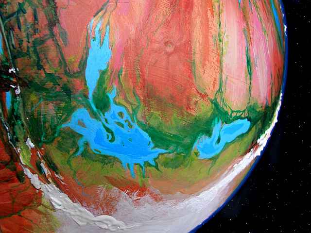
- UGOR SEA, 53-64 S, 2-35 W---an irregular sea 1100 km long and 550 wide (700 by 350 mi), south of the Heloon Desert. A great evergreen forest surrounds the sea. In wetter eras Ugor fuses with the Anthor Sea to the east and the smaller Shaleen to the northwest; this temporary ocean turns the southern desert into a fertile prairie. (source: E.R. Burroughs: U-Gor, but that was a bit too much like U-Save and U-Haul.) Orbital photo to right.
- Ulvas Arm, 47-58 N, 125-140 W---the west end of the Raksar Sea. The Brako Islands, debris from the nearby Ombra Crater, leave only two narrow straits linking Ulvas Arm to the central Raksar Sea. The south shore is evergreen forest full of mop villages; the sparsely populated north is marsh and sparse, chill woods. (source: E.R. Burroughs: Ul Vas)
- Ulvas Crater, 66-68 N, 145-150 W---an impact crater 200 km wide (125 mi), with low walls and a shallow, marshy, sediment-choked floor. Ulvas lies in tundra between Ozara and Raksar Seas, northwest of Ombra Crater. They may be simultaneous scars from a chain of comet strikes. Treeless and windy, Ulvas has no permanent residents, but in summer, mamooks gather for a chong-ma: a music festival, a competition, and a marriage market all in one, where mamooks of both sexes try to impress potential mates with ballads and drum-stories. (source: E.R. Burroughs: Ul Vas)
- Mt Umblam, 21-26 S, 35-40 W---Umblam is the highest and youngest shield volcano in the Jahar Mountains near Heloon Crater. 16 km high (52,500'), the second highest on Tharn, after Mt Tsol in the Chinchaks. Concentric climate belts ring the peak, from Martian down through alpine, forest, savanna and desert. Lava flows form great terraces dropping suddenly in scarps up to a km high. The falls and cascades of the Umblam Terraces make the region a scenic wonder for those species who can breathe the thin air of the heights. (source: mamook name)
- Umka Sea, 64-70 N, 0-30 E---a cold marshy sea 700 km (450 mi) wide, in a treeless tundra basin north of Thuvia Upland. The Umka's fed chiefly by the long Yamfit River to the south. (source: E.R. Burroughs)
V -- jump to A - B - C - D - E - F - G - H - I - J - K - L - M - N - O - P - R - S - T - U - V - W - Y - Z - Names - Sounds
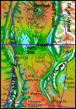
- Vad Lakes, 2-8 N, 83-91 E (disputed; caravan maps have 78-83 E)---four long lakes west of the Varo Sea. Lake Vad is a brackish, alkaline riftlake on the arid floor of Zor Chasma, 410 km long and up to 120 wide (260 by 75 mi). Its dominant fauna are multipedes, bottom crawlers up to 1.5 m long (5'). With their spines, legs and feelers, they look a bit like lobster-centipede hybrids--or Hallucinaria fossils from our Pre-Cambrian Explosion. The other three main lakes, Gerboon, Inkip and Tsip, lie in parallel, cliff-walled fossae (cracks) in the fracture zone just east of the rift. They're all fresh, since they drain into the Varo Sea; their valleys, like their waters, are less exotic than Vad but more fertile. (source: E.R. Burroughs: Vad Varo)
- Lake Vaja (sorry, no link), 20-27 S, 95 E (but caravan maps have 85 E; it's so far off the trade routes that no better data can be had)---a narrow, isolated rift lake in southern Zor Chasma. Vaja is 550 km long and 65 km wide (330 by 40 mi). Every summer Vaja turns lime-green from minerophilic bacteria, fed by black smokers (towering mineral-water vents) in the lake-depths. (source: E.R. Burroughs)
- Lake Vantija, 3-12 S, 85-90 E (disputed: caravan maps have 80-85)---a long equatorial riftlake in Zor Chasma. By far the biggest of Zor's riftlakes, fully 800 km long and up to 100 wide (500 by 65 mi). Brackish, mineralized, and home to unique fauna--giant five-legged "crabs". Some species crawl onto land, though they return to the lake to reproduce. Evolution continues! In a way, Vantija is a time-capsule: Tharnian life first crept onto land from a lake much like this, though Vantija's too young to be the source. (source: E.R. Burroughs: Van-Tija)
- VARO SEA, 8 N to 4 S, 90-98 E (disputed; caravan maps have 86-93 E)---an equatorial sea east of Zor Chasma. Varo itself is 800 km long and 400 wide (500 by 250 mi), but east, west and north, smaller lakes like the Vad Cluster and Lake Ruvallin feed into it; the whole complex forms a water-maze 1000 mi across. (source: E.R. Burroughs: Vad Varo)
W -- jump to A - B - C - D - E - F - G - H - I - J - K - L - M - N - O - P - R - S - T - U - V - W - Y - Z - Names - Sounds
- Wabba Spur, 0-10 N, 150-160 E---Wabba is a side-spur of Dupdup Trench; a wedge of lowland rainforest and lakes 500 km across, between the barren uplands of Artol to the north and Dejah to the west. An active region with many quakes and odd geological structures, like Yakkakee Ring. (source: flyote name)
- Wantholuma Island, 4-7 S, 162-165 E---largest of the Chandika Islands, a chain down the center of the Ksaksa Sea, Wantholuma's a leaf-shaped island 300 km long and 120 wide (190 by 75 mi; triple the size of Hawaii). Bos inhabit Wantholuma's warm, lush forests, along with some centahs in the opener woods of the south end; thotter villages line the shores. (source: thotter name)
- WAROON SEA, 1-15 N, 15-40 W---third biggest sea on Tharn, in the eastern Barsoom Basin. The south shore is equatorial forest; the north, savanna. The water's brackish but drinkable in a pinch. The east end is a shallow but unbroken sea 500 km square (300 mi); the west and south is a maze of marsh, woods and nearly freshwater sounds like Charinthe Bay, Kiarro Sound, Larothe Bay, and Lake Pshu. End to end Waroon is 1600 km long and half as wide (1000 by 500 mi), though there's a lot of land and not-quite-land in there... (source: E.R. Burroughs: Warhoon).
- Washi Crater, 30 S, 80 E (hotly disputed! Both caravan maps and orbital photos range from 26-32 S (the only doubtful latitude in this gazetteer) and 72-80 E. The region is in the heart of a flat, featureless desert, after all)--- An impact crater 20 km (12 mi) wide, on Kindasharo Island in the Proom Sea; in fact, Kindasharo is its debris apron. A lake covers most of the crater floor; the outer slopes are wooded, unusual in this area. Washi is the south end of a long chain of craters: see Zu, Shif Shif, Hiffa, Shira, and Noor Nar Craters. (source: veltaur name)
- Wolak Sea, 31-41 N, 105-115 E---a small bedsea between Dejah Upland and Zor Chasma, north of Parthak Crater. Wolak is 670 km long (420 mi) and half as wide; the rugged, ragged shores are dense evergreen forest, home of elaffes, thotters and mops. (source: E.R. Burroughs)
- Worawora Range, Lake, and Basin, 30-45 N, 60-70 E---Worawora is an arc-range off eastern Thuvia, enclosing one of the most fertile arc basins on Tharn--not that that's saying much! But it has wide prairies where centahs herd flocks, as do camaroos in the cooler hills above; mops have settled along the wooded streams descending from the Worawora and Mrr Ranges to the east and west. The long green shores of Lake Worawora, 2.25 km below datum (7500' down), have even attracted a few lebbirds ; but to them it's a thin-aired frontier, the very edge of the livable world--a mere whisker-tip of their heartland in Mrr Trench. Lake Rru in the eastern Worawora Basin is barely a kilometer below bedlevel, and has no lebbirds at all; flight's just too hard. (source: lebbird name)
- Wrr Basin and Lake Wrr, 0-10 S, 110-125 E (debated; caravan maps have as low as 105-115 E; the basin's a dead end off the trade routes)---a basin about the size of Spain at the southwestern tip of Dejah Upland, just below the equator. Fairly dry for the equator. On the southeast side, below the northern P'tarth Mountains, the basin's riven by a branch of Yoof Trench. In it lies Lake Wrr, nearly 3 km down--just far enough so the denser air will support flight for lean, small lebbirds. Though the muggy trench-heat also selects for light, rangy builds. (source: lebbird name)
- Lake Wssh, 37-43 S, 48? E (little visited region)---Lake Wssh, 560 km long and 100 wide (350 by 65 mi) lies in the bottom of Wula Rift. It's a classic riftlake--brackish, mineralized, with grotesque tufa towers and pyramids on its shore and in its depths, where hot vents feed strange life forms and thermophilic bacteria stain the lake with bloody purple clots. The lake and the rift are well above datum ("sea level") at this point, and the shores are cool steppes, not desert as around Lake Rishish to the north. It's deeper than Rishish, too, for the wooded ridges above the lake are far enough from the equator to get winter snow; the snowmelt feeds the lake even through dry summers. (source: veltaur name)
- WULA RIFT, 15 N to 60 S, 45-120 W---a diagonal chasma--twin ridges where new crust is spreading. Wula is the southern edge of Barsoom Basin in the center of the map. Lake Wula, a riftlake 480 km long (290 mi), lies just south of the equator; Lake Rishish, even larger, lies at 25 south. Orbital photo to right. (source: E.R. Burroughs: Woola)
- WULA SEA, 10-23 S, 38-58 W---a large sea in southern Barsoom Basin, near the huge shield volcanoes of the Jahar Range. Wula Sea is 1300 km long and 700 wide (800 by 450 mi); the southwestern half is an unbroken sheet of water; the northeastern, a maze of sounds, marshes and the Ruha Islands. (source: E.R. Burroughs: Woola)
Y -- jump to A - B - C - D - E - F - G - H - I - J - K - L - M - N - O - P - R - S - T - U - V - W - Y - Z - Names - Sounds
- Yakkakee Ring, Yakkakee Lake, 6 N, 160 E---A lake-filled circular structure between the Artolian Chaos and the Wabba Spur of Dupdup Trench. 175 km across (110 mi), Yakkakee looks like an impact crater, but it's a corona, a sort of colossal sinkhole. (source: flyote name)
- Yamfit River, 40-63 N, 0-30 E---one of Tharn's longest rivers, the Yamfit flows north off Thuvia Upland down to the chilly Umka Sea. The West Yamfit rises in the arcuate Roop Range; the East Yamfit, in the long parallel ridges of central Thuvia, near the Dzel Lakes. Both upper forks are alpine; only the lower stretches near their confluence have sparse forest. (source: mamook name)
- YARR TRENCH and Lake Yarr, 0-16 S, 50 E---An arcuate trench between Thuvia and Sola Uplands, linking Mrr Trench in the north and Dor Trench in the south; all parts of a single huge subduction zone. Much of the trench floor is flooded by narrow Lake Yarr, 600 km long. The climate's hot and rainy, so Lake Yarr is deep; its jungly shores are just 2.5 km below datum (8000' down). It drains south into larger Lake L'ree. In this heat and thin air (for a trench), the local lebbirds are slender and rangy, about the lightest of their species. (source: lebbird name)
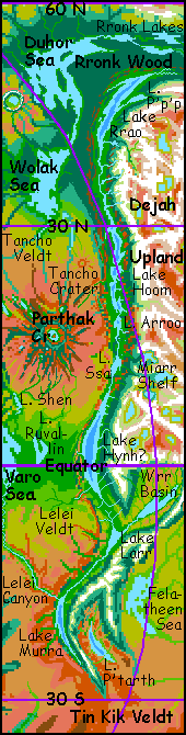
- Yarr Mts, 0-16 S, 48 E---Between Thuvia and Sola Uplands is a rugged region called Molak Isthmus. The Yarr Mts are the eastern rim of this upland. They're andean in height--5-7 km (16-23,000'), but up to 9500 m (31,500') tall, that is, head to toe, for they plummet into Yarr Trench to the east. From the trench floor they're as spectacular as the Himalayas, though less snowy. (source: lebbird name)
- Lake Yaruu, 52 N, 180 W---A narrow east-west lake 400 km long (250 mi) in the Hulam Mts just north of Kantol Rift. The lake drains north into the Ozara Sea. The Yaruu Valley is an oasis in the glaciated Hulams--a cool-temperate valley of subalpine meadows and dark evergreens: the only real forest in the whole Ozara region. mops and camaroos share the valley; mamooks graze the surrounding alps. (source: mamook name)
- LAKE YEGWEH, 8 N to 4 S, 150-165 E---a narrow trenchlake 1200 km long (750 mi), in Dupdup Trench, southeast of Dejah Upland. Yegweh's shores are 3 km (2 mi) below datum. Dupdup Trench is flyote country; at least they're the only flying people who've settled this large air oasis; veltaurs, lobbras and thotters live here too, but these flightless folk only enjoy the dense air's secondary benefits: a stable, hot, humid climate. Crops grow explosively fast. Lebbirds and wingbok have not yet reached this trench, though if they do, they too could certainly fly here. Yegweh is freshwater; it drains into salty Lake Kyekyek to the south, still deeper in the trench. (source: flyote name)
- Yenkit River, 20-33 S, 170 E---The Yenkit is a shallow, gravelly river 1250 km (800 mi) long, rising on the dry south side of the Chinchak Mountains and running due south through the Tin Kik Desert to the wooded shores of Zodanga Sea. (source: lobbra name)
- Lake Yikla, 40 N, 15 W---the southern trenchlake in Roop Basin, just northwest of Thuvia Upland. Yikla is only 320 km long (200 mi), but it's 3.5 km below datum, with air dense enough to support trench wingbok. It's fed by Lake Alinne to the north. Roop Basin narrows just south of the lake, but the trench continues to deepen; Lake Yikla drains through a dramatic canyon down to Lake Hinla in Otz Trench, of which Roop is just a spur. (source: wingbok name)
- Yimpo River, 17-23 S, 165-175 W---the Yimpo is a shallow, gravelly river 900 km long (550 mi), rising on the dry south side of the Chinchak Mountains, running first east then south in a great L, through Hotalka Desert to Gedda Bay on the Zodanga Sea. Much of Hotalka's population lives on its banks. (source: lobbra name)
- Lake Yipyaa, 12 S, 140-145 E---a narrow trenchlake 250 km long (160 mi), in Dupdup Trench, southeast of Dejah Upland. Yipyaa is freshwater. The long Neira River pours into the lake's south end; Yipyaa drains north into larger Lake Kyekyek. This is flyote country--at least they're the only flying people who've settled this large air oasis; veltaurs, lobbras and thotters live here too, but being wingless, only enjoy the dense air's secondary benefits: a stable, hot climate, good for irrigated farming. Lebbirds and wingbok have not yet reached this trench, though if they do, they too could certainly fly here. (source: flyote name)
- Lake Yoee, 56-65 N, 60-67 E (caravan maps say 48-60 E; the difference sounds huge, but this far north, it's just a few hundred km)---a lake 700 km long in the north end of Mrr Trench, east of Thuvia Upland. Lake Yoee, 3 km below datum, is an oasis of warm air in a frigid region; the northernmost woods in the world line its shores. Yoee's quite salty, as the dry polar air evaporates it; the lake only exists because it's fed from the south by huge Lake Mwaa. Home of the northernmost (and some of the largest) lebbirds in the world. (source: lebbird name)
- Yola Ridge, 20-32 N, 20-40 W---A straight ridge nearly 1900 km long (1200 mi), averaging 2 km high, running northeast from the southern tip of Llana Upland to Otz Trench. Like the Indian Ocean's "Ninety East Ridge", it's a line marking the slippage between the fast-spreading Barsoom Plate and the smaller, slower-moving Gwaa Plate to the north, in the lee of Llana Upland. Yola Ridge blocks rain to the plains north of it, creating the Gwaa Desert. The only permanent inhabitants are small, primitive flyotes. (source: flyote name)
- YOOF TRENCH (a slow deflating sigh, like a tired, two-ton businessman falling on a sofa), 50 N to 27 S, 105-150 E---Yoof Trench, west of Dejah Upland, is 7000 km long, up to 160 wide, and 3-5.5 km deep (4500 miles long, 100 wide, 2-3.5 miles deep). Its north end is the homeland of elaffes, a huge, flightless, elephant-snouted people. Its south-central stretch is the hottest place on Tharn, the adopted home of lebbirds and flyotes, who don't mind the heat and like the dense air down in the trench, which eases flight. Yoof holds three main lakes: equatorial Lake Hynh?, Lake Hoom from 20-30 north, and Lake Rrao, 40-50 north (source: elaffe name)
- Lake Yoseno, 43-53 S, 85 W---the middle and lowest lake in Chanath Trench east of Tarkas Upland. A narrow leaf-shape, Yoseno is 670 km long and 120 wide (420 by 75 mi); it lies fully 4.5 km (nearly 3 mi) below the surrounding plains. To the north is Lake Sharoo; to the south, Lake Tavia. Yoseno is inhabited by a unique, seasonally breeding subspecies of trench wingbok. (source: E.R. Burroughs)
Z -- jump to A - B - C - D - E - F - G - H - I - J - K - L - M - N - O - P - R - S - T - U - V - W - Y - Z - Names - Sounds
- Zeep: see Zzeep.
- Zeus---the gas giant that Tharn orbits. Zeus is 200,000 km across (125,000 mi), nearly 50% wider than Jupiter and nearly twice its mass (600 Earths). Its heat puffs it up to only 2/3 Jupiter's density; it radiates enough infrared to feel warm from Tharn's surface. It looks like a huge, swirling, striped, tawny "moon" over 10 degrees wide, some 400 times the area of our full moon, and over 1000 times brighter! Even night-blind humans would see full color at midnight. Though Zeus is 1.15 million km away (720,000 mi), three times the Earth-Luna distance, it dominates the sky (and Tharnian mythology).
- Zhirada Bays, 1-7 N, 90-95 E (disputed; caravan maps have 85-90 E)---Two freshwater bays in the western Varo Sea. West Zhirada is a long narrow sound at the foot of the first ridges of Zor Chasma. It opens into broader, island-dotted East Zhirada Bay, an arm of the open Varo Sea. Each bay's about 300 km long. All the shores are rainforest, inhabited mostly by bos. (source: bo name)
- ZODANGA SEA, 27-44 S, 157 W to 168 E---a shallow sea nearly 3000 km long, though only 500 wide (1900 by 300 mi), south of the Chinchak Range, near Thurian Rift. In wet eras Zodanga sometimes grows enough to merge with the Thark Sea to the west, forming Tharn's largest ocean, greening much of the southern hemisphere. Even today, it nourishes huge Zodanga Wood, an evergreen forest bigger than Alaska, on its west and south shores. (source: E.R. Burroughs)
- ZOR CHASMA, 60 N to 65 S, 80-120 E---one of Tharn's four great rift zones, where new crust is spreading. Zor is a north-south rift valley dotted with lakes, reaching nearly pole to pole. It lies west of Dejah Upland, east of Thuvia and Sola Uplands. Lower and more broken than most, Zor's ridges are not high enough to form a migration barrier to most species. (source: E.R. Burroughs)
- Zozar Plateau, 5-20 N, 30-50 E---An altiplano in southeast Thuvia; as fertile as this upland gets. Some woods even grow along the lower Zozar River, and the riverbottom is irrigated farmland, but most of the basin is a cool, windy sea of grass.
- Zu Crater, 26 N, 80 E (disputed; caravan maps have 85 E)---an impact crater 100 km (60 mi) wide, in a dry plain often called the Zu Desert, just west of Zor Chasma and south of the Zuki Sea. The Zu River rises on the forested heights of the ringwalls, draining north into the Zuki. (Clearly this region of Tharn was sponsored by the letter Z.) The floor of the crater's 1.75 km below datum (nearly 6000' down), just deep enough to sustain trench wingbok as well as large flyotes. Zu is just the north end of a long chain of craters: see Shif Shif, Hiffa, Shira, Noor Nar and Washi Craters. (source: E.R. Burroughs)
- ZUKI SEA, 36-57 N, 87-97 E (disputed: caravan maps have 77-82 E)---a cool, northern sea 1300 km long but only 250 wide (820 by 150 mi), with dark-forested shores. Zuki lies east of Thuvia Upland and west of Zor Chasma. The west coast is fairly straight but the east is a tangle of shallow sounds: treeless Thosh Arm in the far north, then Gomlap Bay, the Insoralta Peninsula and sinuous Insoralta Sound south of it, the marshy Psop Lakes, and at the south end, Manlat and Zu Arms. To the southeast, Lake Rondzin, 160 by 320 km (100 by 200 mi) extends the water-maze. Some arms of the Zuki Sea are silty clambeds, but rocky sections are full of kelp forests, sheltering hordes of fish and large invertebrates. Thotters fish from the shores and islands. They don't venture far inland, though--dense, dark woods cover the whole Zuki Basin, taking advantage of the rain. Two other species share the deep woods: elaffes and mops. (source: E.R. Burroughs: a kangaroo character)
- Zzeep River, 25-45 S, 120 W---A very short river with a large flow, in Har Trench west of Tarkas Upland, 5.5 km deep. The Zzeep drains freshwater Lake Jeet, running 160 km south to brackish Lake Rrit. The arthom evolved in the forests along the Zzeep. (source: artho name)
Jump back to A - B - C - D - E - F - G - H - I - J - K - L - M - N - O - P - R - S - T - U - V - W - Y - Z - Names - Sounds
NOMENCLATURE
Tharn's main features have names adapted from Edgar Rice Burroughs' pulp version of Mars, "Barsoom", which Tharn slightly resembles (well, it echoes many early Marses, from C.S. Lewis through Ray Bradbury. But those better writers didn't coin many names). Lesser and local features are named in the languages of the dominant local species--but where it's physiologically possible, I've tried to make their names echo ERB's loopy style, both sonorous and silly.
If you're curious about the source of a particular name, see the gazetteer above; each entry has an etymological note at the end.
PRONUNCIATION
CONSONANTS
B, D, F, H, K, L, M, N, P, S, T, V, W, Y, Z have fairly unambiguous pronunciations. Letters and combinations needing clarification:
- ch = always church, never chris or loch (see "kh")
- dh = never like adhere, always like this. Common in bo names.
- dz = single consonant, never broken up. Common in thotter names.
- g = as in gargle, never as in George
- gh = a voiced h or hh, like a Spanish j. Common in bo names.
- hh = like Spanish j, harder than English h, softer than Scottish or Hebrew ch
- kh = a strong gutteral, like Scottish or Hebrew ch. For k plus h as in backhand, k'h is used.
- j = as in juju. Never as in Spanish (hh), as in French (zh), or as in Balkan languages (y).
- ll = Longer l, almost a syllable. Never as in Spanish (y).
- Ps, psh = each a single consonant, never broken up. Common in thotter names.
- r = varies by language, from a vowel colored by a curled tongue to strong trills. Rr as a vowel is a throaty purr, a lebbird sound; the closest human vocalization is french r.
- tl = single consonant, never broken up. Common in wingbok names.
- th = always think, never these (dh) or fathead (t'h).
- ts = single consonant, never broken up
- zh = voiced sh sound, the consonant in Asia
VOWELS
There are eight vowels you'll encounter. A, E, and O are roughly as in Spanish or Japanese; I is perhaps more as in English ship, and U more like English put. Three more vowels:
- ee = always feet, never fiancee. Always a strong syllable.
- oo = always boot, never foot. Always a strong syllable.
- ü = as in French, German, Chinese. If it's unfamiliar, say eeee, then make your lips a tube as if you're saying oo without shifting your tongue from its eeee shape.
ACCENT, LENGTH AND EMPHASIS
Accent or emphasis is usually on the penultimate syllable. Doubled vowels like ee or oo, and diphthongs like ai, ao, ei, eo, iu, also mark accented syllables, and so do doubled consanants after a vowel, like emm, att, orr. There are no silent vowels; final e is always pronounced.
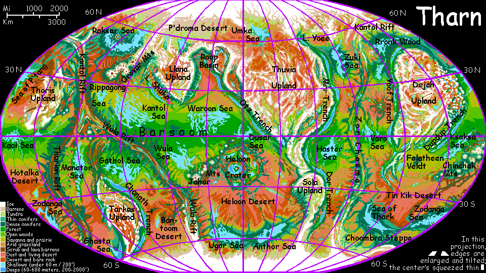 Gazetteer: index of place names with descriptions. Or
TOUR THARN! The following route snakes around Tharn, covering all major features
Gazetteer: index of place names with descriptions. Or
TOUR THARN! The following route snakes around Tharn, covering all major features
Tarkas Upland -- Tars Triangle -- Thoris Upland -- Raksar Sea -- Llana Upland -- Barsoom Basin -- Jahar Range -- Heloon Crater -- Heloon Desert -- South Pole -- Sola Upland -- Otz Trench -- Thuvia Upland -- Mrr Trench -- Far North -- Rronk Woods -- Parthak Crater -- Hastor Sea -- Varo Sea -- Yoof Trench -- Dejah Upland -- Dupdup Trench -- Felatheen Veldt -- Chinchak Mts -- South Seas -- Polodona Wood -- Sea of P'Tang
LISTS AND LINKS: more world-models:
Planetocopia - dreams of
other worlds -
ecology -
climate -
hot & cold-
evolution -
anarchy &
utopias -
sculptures & 3D art
World Dream Bank homepage - Art gallery - New stuff - Introductory sampler, best dreams, best art - On dreamwork - Books
Indexes: Subject - Author - Date - Names - Places - Art media/styles
Titles: A - B - C - D - E - F - G - H - IJ - KL - M - NO - PQ - R - Sa-Sk - Sl-Sz - T - UV - WXYZ
Email: wdreamb@yahoo.com - Catalog of art, books, CDs - Behind the Curtain: FAQs, bio, site map - Kindred sites