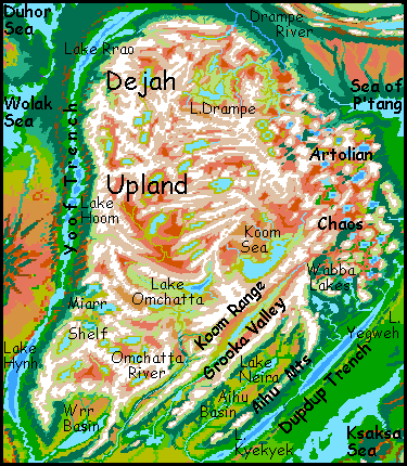
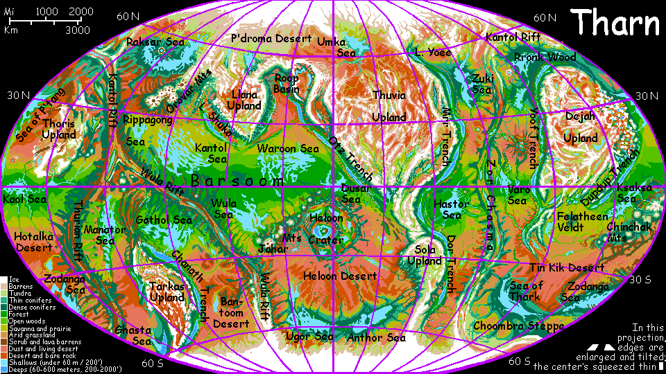
Dejah Upland
by Chris Wayan, 2005-6
Map, Tharn's homepage, Peoples of Tharn, Regional tours, Geology and Evolution, gazetteer, terms explained. More worlds? Planetocopia!
INTRODUCTION
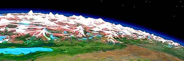
Dejah is a continent-sized upland, the second largest on Tharn, about 10 M square km (4,000,000 sq mi)--bigger than Europe, the USA or Canada. It stretches north from the equator inside the arc of the Zor and Kantol Rifts--spreading zones whose basaltic plains have been pushing underneath Dejah, creating high mountains and plateaus, for at least a hundred million years.
As a result, much of Dejah is barren, especially the Tibet-like west. The east side is a peculiar lake district called the Artolian Chaos unlike anything on Earth; the north is broken by the relatively fertile alpine basin of the Drampe River. South of the central Koom Sea, the upland frays into arc-ranges and subalpine basins--by far the warmest part of Dejah, but dry for equatorial lands. In the far southeast past the Wrr Basin, Dejah has a forked "tail" called the P'tarth Ranges (just off map) looming over fertile Yoof Trench; in the far southwest is Dupdup Trench, climatologically similar to Yoof but with wildly different dominant species.
THE WEST
On Earth, wherever you find a subduction trench, there's a great mountain range nearby on the upper plate. The stacking of two plates pushes the rim up; also, as the lower plate slides into the Earth, it heats and melts; lighter material rises as magma. In spots (off the southern Andes, for example) volcanoes tower up to 10-14 km above trench floors. Such extreme relief is in the same range as Martian volcanoes, and in a far higher-gravity environment. We overlook just how vertical Earth is, for much of its relief is sea-hidden.
On Tharn, the full relief of these subduction zones is exposed. The Yoof Mountains, paralleling Yoof Trench for most of its length, is typical--Himalayan in absolute height, but measured from their feet deep in the trench, they stand 12 km high: 40,000'!
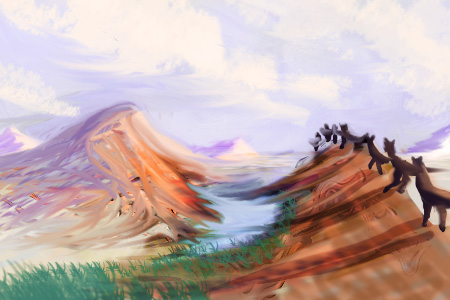
This great wall squeezes nearly all the rain from lowland winds; so the western slopes are lush, from alpine deserts where shaggy mamooks roam, to high meadows where camaroos herd their flocks of Woolly Anoxia, to deep mountainside forests where mops raise their lodges and totem poles; the lower gorges have air dense enough for small winged species like flyotes, and the depths support tropical lebbirds. That's only a partial list--so many species with diverse habitats rub shoulders on these steep slopes that a rich multiculture has arisen: the Yoof Slope is one of Tharn's hotspots of innovation, both cultural and technological.
In contrast, the upland side of the mountains is as stark as Tibet. Cold brackish lakes in redrock basins below icy peaks, with few meadows and fewer people--of any species. Western and northwestern Dejah are its barrenest region--not just due to height, but the rainshadow. The Yoof Range giveth, and taketh away...
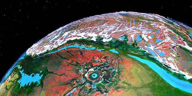
This drastic simplicity breaks up in one stretch: Miarr Shelf (lakes to center right in the orbital photo above). Here the front range fractures and retreats from the trench. Too rugged to be called a plateau, Miarr's a cluster of subalpine lake-basins, 2.5-4 km up (8-13,000") supporting a dense population of camaroo farmers and pastoralists. Miarr resembles the Ethiopian Highlands in size, latitude and altitude, but the climate's harsher--Tharn's orbital eccentricity give it strong seasons. Still, it's mild for Dejah! Its four large (and hundreds of small) lakes all drain into Yoof Trench--a dry stretch of it, as it happens, so these streams are welcome sources of irrigation, supporting hundreds of cliff villages. It sometimes seems, on a world as marginal as Tharn, that every oasis has a price--casting a rainshadow or stealing air from a neighboring province. But Miarr is a win-win region.
THE NORTH
Northern Dejah is dominated by the Drampe Basin, Tibetan in size and climate. It's divided in roughly equal halves. In the western, upper half, C-shaped Lake Drampe, 190 km long (120 mi), collects milky streams in a red-gold wasteland; the West Drampe River flows east through a narrows between two snowy ranges 7 km high, into the lower eastern basin--still alpine, but grassier, with dwarf woods along sheltered stretches of the river.
The West Drampe winds across this plateau; soon after it joins with the South Drampe, the combined river turns north and drops off Dejah Upland through 300 km of rapid and falls, into forest--the east end of Rronk Wood. The Drampe bends sharply west to drain into the Rronk Lakes and finally the Duhor Sea. The river's 1900 km long (1200 mi), though its source and delta aren't far apart--horizontally, that is!
The lower plateau is summer pasturage for flocks herded by camaroos, who retreat to the lowlands in orbital winter, where they shelter in Rronk Wood, weaving in villages shared with mops and elaffes. The upper Drampe is exclusively mamook country. Not that they wouldn't welcome settlers of other species; it's just that no one else wants it.
CENTRAL DEJAH--THE KOOM SEA
The largest high-altitude sea on Tharn, brackish Koom looks from space like a twisted blue barbell 720 km long and 320 wide (450 by 200 mi). It's large enough to moderate the temperature swings of this high-altitude climate. The shores are salt marsh and Andean altiplano stretching hundreds of kilometers, except the southeast shore, which rises quickly into the lofty Koom Range, higher than our Himalaya and heavily glaciated.
All that fine-ground glacial silt has made the Koom Basin surprisingly fertile for its altitude. Camaroos grow successful gardens along creeks and herd woolly anoxia on the meadows.
To the west over a lower range, a mere 5-6 km high (16-20,000'), lies smaller Lake Omchatta, a triangular lake 330 km (210 mi) long and nearly 4 km high; a real garden spot (by Dejah's low standards) for this water's fresh; no salt-poisoning and a stable shoreline too. From its west end, the Omchatta River, 3200 km (2000 mi) long, winds southwest through broad alpine meadows for 500 km, then slices a deep, straight canyon out of the uplands, down to the Felatheen Sea.
THE EAST: ARTOLIAN CHAOS
Four hundred million years ago, on the far side of Tharn, the huge Heloon impact dug out a monstrous crater and caused a planetary firestorm. It was so big, the whole globe rang--and tore. Here in eastern Dejah, exactly opposite the crater, there's a huge, chaotic upland of snowy peaks and lake-filled basins, formed at impact by shock waves converging round the world, as if Tharn were a great lens.
Even Earth's busiest volcanoes take ten thousand years to reach Andean heights. The Artolian Chaos rose in ten minutes! And rose is too mild a word: leapt into low space and fell again in a rain of red-hot mountains.
Once far higher than the Himalaya, they've eroded down to merely Andean size. But even today, the strangeness of the land is visible from space--Artol has a cellular look, like the standing waves in a vibrating pan of water. Such chaoses are known in our solar system too; Mercury has a violently torn-up region opposite its huge Caloris Basin.
In fact, Artol got off easy. Compare the locations of Mars's two great impact basins (Hellas and Argyre) and volcanic uplands (Tharsis and Elysium). Not exactly opposite, but close enough to be suggestive (if you postulate some hot-spot drift toward the equator, make that very suggestive. Continents on Earth do feel centrifugal force--but surely the Martian bulges aren't drifting like Terran continental plates... are they?
 Or the magma plumes could be denser than surrounding rock, so they were bent equatorward by centrifugal force. Or the two vast holes, lighter than the surrounding highlands, could be wrestling the whole planet so they creep toward the poles--again with no moving plates.) Now Mars has a cool crust, hard for volcanic vents to melt or burst through, so once they did, the volcanoes grew and grew.
Earth may even be a poster child for chaos. The current acrimony over the death of the dinosaurs--Chicxulub impact or Deccan Traps?--asteroid or volcanoes?--has so far mostly ignored the possibility that the former either caused or exacerbated the other. Both the Impacters and Trappists (ha) dismiss the idea smacking Earth could trigger or stimulate massive vulcanism with "Nonsense! It was already active, and on the far side of the world!" Which of course means the biggest shockwaves in a billion years all converged right on an already erupting volcanic field. The few impacters who are planetologically literate enough to realize this, dismiss it more subtly with "They don't line up, Deccan wasn't the target." But India AND Yucatan have moved a lot in 66 million years--back then, the line-up was quite good--at most a thousand miles from a bullseye. The quake would have been unimaginable. The Deccan had to rip itself open in response. Since the crust was already thin and cracking, rather than a mountainous Artolian Chaos, we got low peaks but lava flows up to 1000 km long, a field big as France, kilometers thick.
So I see both sides as right/wrong. A bomb bigger than our world's whole nuclear arsenal blasts one hemisphere; the shock stimulates volcanoes to poison what the blast didn't burn or drown...
Sorry, I do get carried away. Ooh, impacts go BOOM! Go boom TWICE! Speculation is such sweet sorrow...
Let's get back to firmer ground--what a laugh! Tharn's a total speculation, AND of all its ground, Artol has to be the shakiest. Chaos! Though in fact, all that melted mess held together pretty well, once it cooled. Lava welding holds up! And after the temporary shock, it seems like Tharn's mantle just went about its business serenely. Magma went on circulating in existing convection loops--the same old trenches, rifts and volcanoes. Surprising; but then, Artol arose near several active zones that could relieve any pressure, like Kantol Rift Zone and Dupdup Trench. Mars is armored, and prone to outbursts if you get under his thick skin. But Tharn's a sly, wrinkled old woman, used to expressing her magma, er, feelings. You don't live to be eight billion by holding it all in.
So the chaos formed a great blunt tongue sticking out from Dejah Upland--but not a constantly active, volcanic upland like some continents on Earth or a Martian volcanic bulge. There are indeed volcanoes--at least three white cones taller than Denali are visible even from orbit. But compared to the great fiery boils Mars developed, Artol is quiet.
The east edge of the chaos, near the Sea of P'tang, is greener; rain gets in, accelerating erosion, and the random basins have linked into sane drainage systems and gnawed the peaks down to Alpine scale, low enough for life to creep in. Trees ring the lakes and line the rivers. But further west, over a dozen waves of jagged peaks, the air's thin and wrung quite dry. Here the catastrophe's never healed: the peaks tower, the treeless basins still have no outlets, and the few lakes are brackish and ringed in cold saltmarsh or rusty mudflats. Even mamooks just visit.
Ironic that the impact site, Heloon Crater on the far side of the world, is one of Tharn's lushest oases. Blast away a trillion tons of rock, and Eden blooms (eventually). But here, where that extra rock was (indirectly) deposited, life has never recovered. The closest Tharn comes to Mars!
Ironic--but not a bitter irony. For if you add the scant biomass of Artol and the rich one of Heloon (that huge air oasis) you'll find their average is still denser than usual for Tharn. Artol's ecological sacrifice was worth it--from a worldwide perspective.
The lesson is broader than Tharn. It's nearly true on Mars. Hellas Basin has air dense enough to allow liquid water even now; were Mars just a bit warmer, we'd see it come to life--in the pit of its biggest crater, and nowhere else. Such scars widen the range of habitats and create refuges in extreme times.
Speaking of time... the net gain of life from this catastrophic spatial displacement has an analogy in time: seasons! It's one reason I've emphasized that eccentric orbits aren't all bad. They can create warm or rainy seasons in places (regions or sometimes whole worlds) that'd be unlivable with an even climate. Consider a cold world with a circular orbit: not quite a snowball, for ice-free seas ring its equator. Since the tropics are pretty stable, equatorial lands never get significantly above freezing, and may glaciate. But an eccentric orbit could give this cold world's tropics a harsher winter--but ALSO a livable summer. Similar arguments hold for dry worlds with a wetter equatorial strip, like Tharn; seasonal rains from an eccentric orbit might spread the livable zone wider than the (relative) year-round equatorial stability of Earth. When the average is suboptimal, eccentricity's good. When the average is dismal, extreme swings may bring life.
Of course I would never claim this Doctrine of the Virtue of Extremes applies to you.

THE SOUTH
Dejah's most fertile region. True, the competition's weak. (And "weak" here means "laid up in a hospital ward peering out of a mass of bandages." Let's face it, most of Dejah's harsh and poor.) Three great parallel ranges, the Aihu, the Neira, and the Koom, divide very different valleys: lush Dupdup Trench (meriting its own page), semiarid Aihu Basin, and the alpine Grooka Valley.
Aihu is an arc range and basin, on the right in the photo. The snowy Aihu Mountains, 6 km high (20,000') form a long front above Dupdup Trench (long lakes). West of them is the Aihu Basin, 1600 km long (1000 mi). The basin slowly rises to the north, from dry veldt (near desert in spots) to a greener savanna with scattered trees; at this upper end lies leaf-shaped Lake Neira, two km high, cupped in "oak"-studded Mediterranean hills. The Neira River runs down the length of the basin, around the Aihu Range's end, down into Dupdup Trench to Lake Kyekyek. The water ends up not far from its source--just ten km lower!
Aihu and Neira are both veltaur names; the hills and plains around Lake Neira are about the highest habitat on Tharn for these playful, social plains grazers, adapted for warm veldt... and just too fidgety to tolerate clothes. This Neira subspecies is distinctly shaggy (and tiger-striped)--quite a contrast to their slender, heat-adapted cousins in the sweltering depths of Dupdup.
The Grooka River runs southwest off Dejah Upland. To the north is the Koom Range, to the south, the Neira, both Himalayan in height. This straight, deep valley is alpine for most of its 1600-km length, though evergreens grow along the river's lower stretches. Grooka parallels the Neira to the east and the Omchatta to the west, much like the deep parallel river-canyons gashing southeast Tibet. Of these three, Grooka is the highest and coldest, cold enough for mamooks to graze its upper end; yet only its upper tributaries have mamook and camaroo names. In fact all three river-names reflect the dominant species of their lower stretches, who of course interact most with the rest of Tharn: thotters along the Omchatta, mops along the wooded lower Grooka, and veltaurs along most of the much warmer Neira--indeed, the whole Aihu Basin is more like Kenya or the Deccan than the Tibetan foothills.
The south ends of all three basins open onto the vast Felatheen Veldt.

THE P'TARTH RANGES
The P'tarth Mountains are a rugged southern extension of Dejah Upland, looking like a forked, dangling tail over 2000 km long (1300 mi). Its dark forests and snowy peaks contrast with the red deserts and golden veldts around it. To the west lies Lake Murra in Yoof Trench; to the east, the Felatheen Sea and vast savanna plains. Nestled between the east and west ranges lies Lake P'tarth, 450 km long and only 60 wide at most (280 by 37 mi). Despite its depth and long narrow shape, Tharnians don't consider it a trenchlake, for it lies a mere 600 m (2000') below bedlevel. Sure, that's deeper than the Dead Sea, but that's nothing on Tharn! Some flyote colonies live here, but no lebbirds--flying's too hard for them in the thin air. But extensive lobbra farms surround the lake, wherever divertable streams descend, suitable for irrigation. Thotters fish from the shores, and centah ranches range far up the slopes. Even a few mops can be found in the cooler hill-forests above the savanna.
The P'tarth uplands have a rich mixture of peoples: plains species like centahs, veltaurs and lobbras rub shoulders (or haunches, or more intimate parts in the case of veltaurs) with mountain folk like mops (a light, lanky, short-feathered subspecies hardly deserving their featherduster nickname) and even a few camaroos.
Each orbital winter, caravans of camaroos trek south along the West P'tarth Range. At its southern tip, where it trails off into a near-desert plain, is one river that doesn't flow either west into Lake Murra or east into Lake P'Tarth--the Mintibom River flows due south, crossing the desert, to the Sea of Thark--gateway to a vast cool-temperate zone, an evergreen forest stretching 5600 km (3500 mi) from Thark to the Zodanga Sea, a fourth of the way around the world. Earth's trade was shaped by straits and isthmuses; great ports are often world-wise and progressive, while continental interiors languish in absolutism. Dry Tharn's equivalent "straits" are caravan-routes with favorable temperatures, dense air or reliable water; Mintibom is one.
These diverse species with their differing world-views, plus the annual stimulus of the Mintibom caravans, have made lonely-looking P'tarth a distinctly more cosmopolitan region than the Wrr Basin to the north, or indeed most of Dejah. Most uplands on Tharn are poor, not only ecologically but culturally; and Dejah's typical. When it comes to trade and innovation, P'tarth is the tail that wags the dog. Well, the forked tail that wags the swallow...
World Dream Bank homepage - Art gallery - New stuff - Introductory sampler, best dreams, best art - On dreamwork - Books
Indexes: Subject - Author - Date - Names - Places - Art media/styles
Titles: A - B - C - D - E - F - G - H - IJ - KL - M - NO - PQ - R - Sa-Sk - Sl-Sz - T - UV - WXYZ
Email: wdreamb@yahoo.com - Catalog of art, books, CDs - Behind the Curtain: FAQs, bio, site map - Kindred sites