Felatheen Veldt
by Chris Wayan, 2005-6
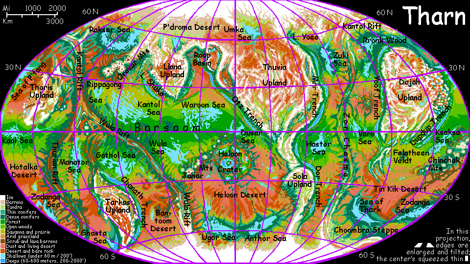
Map, Tharn's homepage, Peoples of Tharn, Regional tours, Geology and Evolution, gazetteer, terms explained. More worlds? Planetocopia!
INTRODUCTION
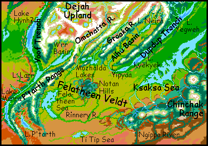
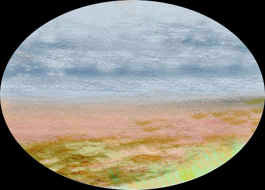
Felatheen is one of the largest savannas on Tharn--a warm, grassy plain covering 2.5M sq km (a million sq mi). To the west is the small Felatheen Sea below the P'tarth Mountains; to the north, Dejah Upland; to the east, Dupdup Trench and the Ksaksa Sea; to the southeast, the volcanic Chinchak Range, and due south, the immense Tin Kik Desert.
Felatheen Veldt resembles the Sahel, the dry grassy plain fringing our southern Sahara, though Felatheen is greenest to the north, near the equator and Dejah Upland, drying to the south--the opposite of the Sahel. In the center of the plain rise the Notan Hills, an ecological island of brush and open woods the size and height of the Aďr Mountains in the Sahel, but greener--a better comparison might be France's Massif Central. Tree-lined streams from the hills wind across the western veldt to the Felatheen Sea. Streams east of the Notan Hills collect into the Neira River, which runs down into Dupdup Trench.
Weather's unpredictable on the Felatheen plains. In orbital winter, Dejah Upland sends cold dry winds down across the plains, but unlike Earth's mistrals, siroccos or foehns, this airmass hits real heat, for even in winter, equatorial Felatheen is quite warm. The clashing air generates thunderstorms, but these rains are patchy and unreliable. In summer the winds mostly reverse, coming generally from the south; but the Tin Kik Desert sends no rain. When wetter winds blow, west from the Felatheen Sea or east from the Ksaksa, then storms batter the great mountains around the plain--they're so high, they can wring rain from quite modest clouds. Rivers swell, but the flatlands still get only occasional rain (mostly in the east near the Ksaksa shore).
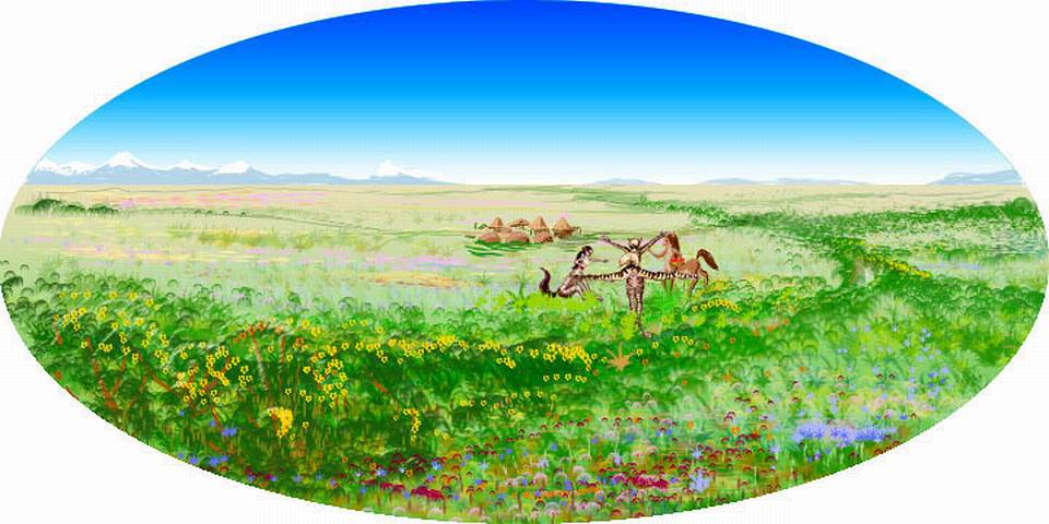
Due to the whimsical rains, locals don't farm the veldt except along snowfed rivers, where veltaurs (once nomadic browsers of the veldt following the rains) now irrigate gardens. Still, when the rains do come and the great plain turns briefly verdant, veltaurs congregate and dance in great festivals.
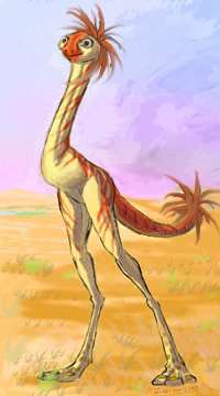
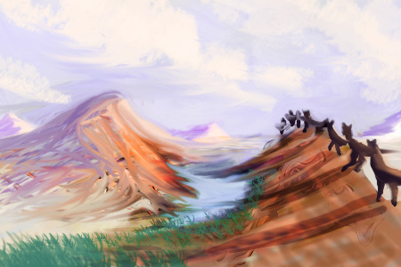
Out on the plains, nomadic centahs still do follow the rains; originally hunter-gatherers, today they also herd small flocks of losha, a sort of egg-laying (but mammalian) ostrich with a mop of red feathers on each end. Presumably this confuses predators. It certainly confuses losha. Their three primary emotions are bewildered, scared, and bewildered. Centahs measure wealth in losha; understandable, since this one beast converts the endless grass into meat, milk and eggs.
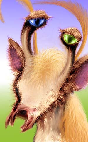
A second nomadic species can eat the grass directly: lobbras. That's not their name for themselves, of course (it roughly transliterates tingpop) but it sums them up: if a mad scientist crossbred lobsters and zebras...
Large bands of these highly social people wander the plain, constantly browsing new growth. But some have settled along streams like veltaurs, for berrying, nut-hoarding, root-digging and larva-harvesting led lobbras to agriculture early on; in fact many plains crops now grown by other species were originally Lobbran.
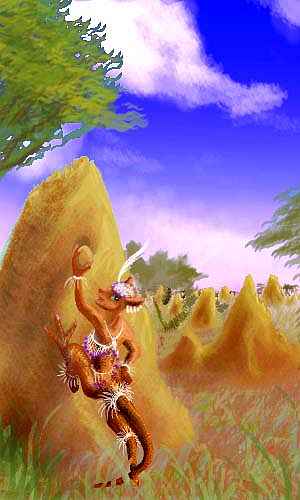
They also developed the Tharnian equivalent of honey, secreted not by bees but by thumb-sized, hopping, stubby-winged cricketlike pollinators living in mud skyscrapers, much like our giant termite mounds (the mud towers of wild colonies dot the drier parts of the plain, especially east of the Notan Hills). The technique has spread to several other peoples, including bos; pictured here is a bo removing the honey-plug from a mud tower, which must be done daily or the "termites" will cement it securely...
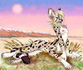
Lobbras are natural gardeners--their mothlike antennae can smell a plant's genetic variations, maturity, health and illnesses long before they're visible to others. And not just plants: veltaur villages generally have at least a few lobbra herbalist and healers in residence, and even nomadic centahs will travel days to consult lobbra shamans for serious chronic and infectious illnesses, just as most Tharnians rely on centah doctors for bonesetting or other surgery (being primarily herbivores, veltaurs and lobbras are too squeamish to be good surgeons. Full-grown veltaur stallions often faint at the sight of their own blood).
Other peoples do inhabit the fringes of Felatheen. Thotters fish the lakes and streams of the rainier foothills around the savanna's edges, and bos live in the scattered woods. In the cool upland forests and alpine meadows above, mops and camaroos predominate. But most plainsfolk are veltaurs, lobbras and centahs--others can't take the heat.
THE WEST
This end of the veldt is dominated by the Felatheen Sea, a brackish bedsea 800 km (500 mi) long, but wider than 100 km only at its north end. Felatheen's shores are marshy and flat; it's just the low point in the great veldt. Snowfed, permanent, and far bigger than Lake Chad in the Sahel, Felatheen Sea humidifies the air of the western veldt for hundreds of km; scattered groves surround the lake (the nearest thing to a forest anywhere on the plains) and true forest mantles the P'tarth Range just to the west.
In the Felatheen Marshes, thotters become a fourth species integral to the mix. Not simple fishers but aquaculturalists, they "herd" parru (creatures a bit like small hadrosaurs) harvesting their copious eggs. Rubbery eggs, with a flavor that's, well, assertive--like a blend of sesame, tobacco, and kelp. Definitely an acquired taste! But plenty of Tharnians have acquired it; parru eggs are a major export item. Coated with dried mud, they'll keep for up to a year--waiting for the summer rains!
 To the west rise the P'tarth Mts--twin ranges extending south from Dejah Upland. This is mop and camaroo country, though the uplands are split by a deep valley. Narrow Lake P'tarth, 450 km long and only 60 wide, lies at the bottom. Despite its shape, depth, and geology (apparently a nascent, secondary trench), Tharnians don't consider Lake P'tarth a true trenchlake, for it lies only 1.3 km (4500') below bedlevel; the air's too thin and dry for a full trench ecology, though large, big-brained flyotes live here. Extensive lobbra farms surround the lake, wherever divertable streams descend, suitable for irrigation. Thotters fish from the shores, and centah ranches range far up the slopes.
Just west over the last P'tarth range lies a true, undeniable trenchlake, Lake Murra, in the south end of Yoof Trench. Home to huge winged lebbirds, its ecology and civilization are so different it might as well be another planet, a sophisticated one. That's a steel-nib pen and a (round) sketchbook; while I sketched this lebbird, she was sketching me.
P'tarth's snowy ranges are a formidable barrier to east-west travel, but a migration corridor for cold-adapted Tharnians traveling north-south. Each orbital winter, caravans of camaroos trek south along the West P'tarth Range.
Most of P'tarth's streams flow either west into Lake Murra or east into Lake P'Tarth. But at the range's southern tip, where it trails off into a near-desert plain, one river, the Mintibom, heads due south right across the Tin Kik Desert down to the Sea of Thark. Quite by geographic chance, the Mintibom's become the gateway to this vast cool-temperate zone, an evergreen forest stretching 5600 km (3500 mi) from Thark to the Zodanga Sea--a fourth of the way around the world.
Earth's trade was shaped by straits and isthmuses; great ports are often world-wise and progressive, while continental interiors languish in absolutism. Dry Tharn's equivalent bottlenecks are caravan-routes with favorable temperatures, dense air, or reliable water. Due entirely to the Mintibom caravans, rugged, lonely-looking P'tarth is distinctly more cosmopolitan than many parts of the Felatheen plain!
THE NORTH
Northern Felatheen lies under the rim of Dejah Upland, a continent-sized plateau. The long P'tarth Range, 6 km (20,000') high, is the northwest border of Felatheen Veldt; but to the east, a valley opens up between lower, wooded hills merely half as high: the mouth of the Omchatta Valley, running some 2000 km northeast into central Dejah. Most of the long river is alpine, but once the rapids descend below 1500 m (5000'), veltaur villages line the riverbanks. This Lower Omchatta is an irrigated oasis like the Nile Valley, stretching all the way to the Felatheen Sea.
Just to the east are the Mozhalda Lakes, a chain of three brackish but drinkable lakes, each 80-125 km across (50-80 mi). They're the end of the Grooka River, a second great snowmelt stream from Dejah Upland, 1600 km long. Grooka parallels the Neira to the east and the Omchatta to the west, much like the deep parallel river-canyons gashing southeast Tibet. Of these three, Grooka is the highest and coldest, cold enough for mamooks to graze its upper end; yet only its upper tributaries have mamook and camaroo names. In fact all three river-names reflect the dominant species of their lower stretches, who of course interact most with the rest of Tharn: thotters along the Omchatta, mops along the wooded lower Grooka, and veltaurs along most of the much warmer Neira.
The Mozhalda Lakes, however, are Mediterranean lowlands too hot for mops; here bos predominate (Mozhalda is a typical bo name: all their consonants are voiced.)
East of the Mozhalda chain, past the end of the Neira Mountains, Aihu Basin opens up. By far the largest of the three valleys, it's an arc basin 1600 km long (1000 mi), it's like a great tongue of Felatheen Veldt sticking into Dejah. The basin rises steadily to the north, from dry veldt to green savanna with scattered groves; at this upper end lies Lake Neira, two km high, cupped in "oak"-studded Mediterranean hills. The Neira River runs down the length of the basin, around the Aihu Range's end, then down into Dupdup Trench. The water ends up not far from its source... just ten kilometers lower!
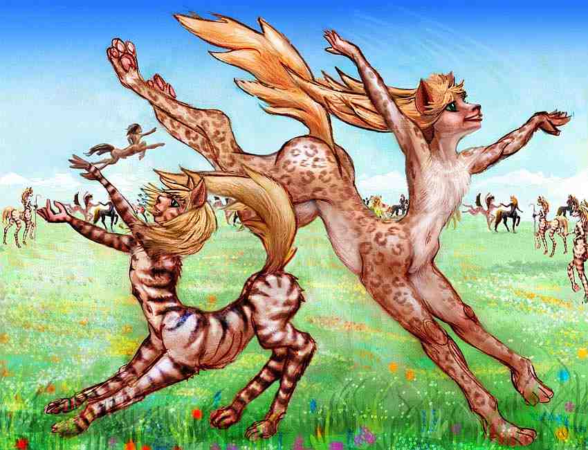
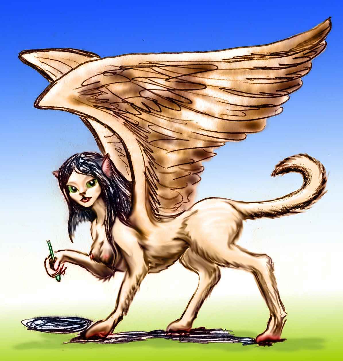
Aihu and Neira are both veltaur names; the hills and plains around Lake Neira are about the highest habitat on Tharn for these playful, social grazers adapted for warm veldt... and just too fidgety to tolerate clothes. This Neira subspecies is distinctly shaggy (and tiger-striped)--quite a contrast to their slender, heat-adapted cousins in the sweltering depths of Dupdup.
The northeast edge of Felatheen Veldt is the Neira River as it runs along the feet of the snowy Aihu Mountains, 6 km high (20,000'), down into Dupdup Trench--a region so peculiar it merits its own page.
THE EAST
This third of Felatheen Veldt is greener, for rains are more reliable--trees and villages needn't huddle along the rivers. The rains blow in off Ksaksa Sea, a triangular equatorial sea between Dejah Upland and the Chinchak Range. Ksaksa is a good 1700 km long and 400 wide (1060 by 250 mi); the large, fertile Chandika Islands run down its middle. The shores are all wooded, though they do quickly thin to savanna to the south and west. In this rich, mild region, half a dozen peoples live flank to flank: bos, thotters, veltaurs, centahs, lobbras, and small flyotes.
The forested eastern shore of Ksaksa Sea is the beginning of Polodona Wood, the greatest rainforest in this hemisphere, covering perhaps 2M sq km (as big as Indonesia or the Orinoco Basin).
SOUTHEAST
The Chinchak Range is an equatorial volcano-chain south of the Ksaksa Sea. Though the range is near the equator, the range is so high and massive that extensive alpine meadows give way to stony barrens and glaciers; little multicellular life survives above 11 km--and that's only waist-high on the Chinchaks.
The high point is Mt Tsol, near its east end: 16.4 km high (54,000'). Tsol Caldera is a massive Olympus-type shield volcano, hundreds of km across. Broad, concentric climate belts ring Mt Tsol, from Martian down through Himalayan, alpine, evergreen forest, and open, Mediterranean woods and scrub. At the great peak's foot, desert stretches to the south, rainforest to the north, and savanna east and west.
Lava flows here and throughout the Chinchaks have formed great terraces, each an ecological sky-island. Rivers wind lazily across these plateaus, then drop in spectacular falls to the next terrace.
While Terran uplands are generally not a place to seek culture, the Chinchak Terraces create habitat for many species in close proximity. Half a dozen peoples share the Mediterranean foothills, often in mixed towns: heat-loving species like the graceful equine veltaurs, scaly bos, and elegant feline centahs; riverine thotters, and even a few jabbering flyotes. By one-fifth of the way to the top, it's all cool, dense evergreen forests, and most of the residents are squawking, feathery mops and chubby camaroos. In the alpine zone above, only camaroos and huge mamooks remain--the only Tharnians able to breathe such thin air. Even mamooks avoid Mount Tsol and the other caldera rims; those near-Martian heights are quite unbreathable, even for them.
Silence and stars at noon...
On Earth, high mountains may be scenic, even holy, but they're rarely cultural centers. Quite the opposite: transport's difficult, fertility's usually low. Consider the word "hillbilly"! The Chinchak volcanoes push this even further; their heights stand outside most of the atmosphere; truly dead lands. Yet these upwellings of death have created one of the liveliest cultures on Tharn on their slopes. So many habitats, so close together! Here, contact and trade between species who elsewhere would never meet becomes easy. The pooling of ideas has made the Chinchak Terraces tolerant, progressive, and technologically advanced. It's a common pattern on Tharn. Civilization huddles around seas, in the depths of trenches... and on mountainslopes like these.
SOUTH
Southern Felatheen fades gradually into the Tin Kik Desert. This featureless, streamless plain may be a lot warmer than Mars, but it's nearly as dry--and dusty. Skies change color by the minute, but not with rainclouds. The thunderstorms nourishing the north are vanishingly rare.
It's debatable if the border should be the Rinnery River, flowing west from the Chinchaks to the Felatheen Sea, or the Ti Tip Sea, a shallow, brackish lake 400 km south, which drains much of the desert beyond. Fully half the population of southern Felatheen lives along the Rinnery--its snowmelt is clean and reliable.
The waters of Ti Tip are neither. Marshy, muddy, brackish and slightly alkaline, prone to both flood and drought, it's mainly a watering hole for nomadic centah herders in orbital summer, when other sources in the desert dry up. The only year-round residents are fifty billion flies.
It's a long hard caravan over Tin Kik Desert to the South Seas, about the loneliest of Tharn's major greenbelts--but one of the largest too.
World Dream Bank homepage - Art gallery - New stuff - Introductory sampler, best dreams, best art - On dreamwork - Books
Indexes: Subject - Author - Date - Names - Places - Art media/styles
Titles: A - B - C - D - E - F - G - H - IJ - KL - M - NO - PQ - R - Sa-Sk - Sl-Sz - T - UV - WXYZ
Email: wdreamb@yahoo.com - Catalog of art, books, CDs - Behind the Curtain: FAQs, bio, site map - Kindred sites