The Northlands
or
Sholika's Lope
by Chris Wayan, 2005-9
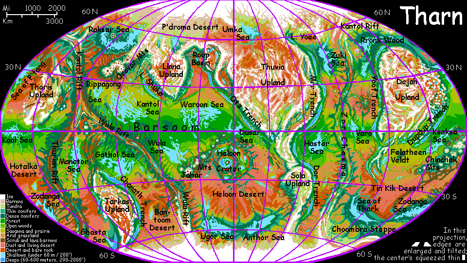
Map, Tharn's homepage, Peoples of Tharn, Regional tours, Geology and Evolution, gazetteer, terms explained. More worlds? Planetocopia!
INTRODUCTION
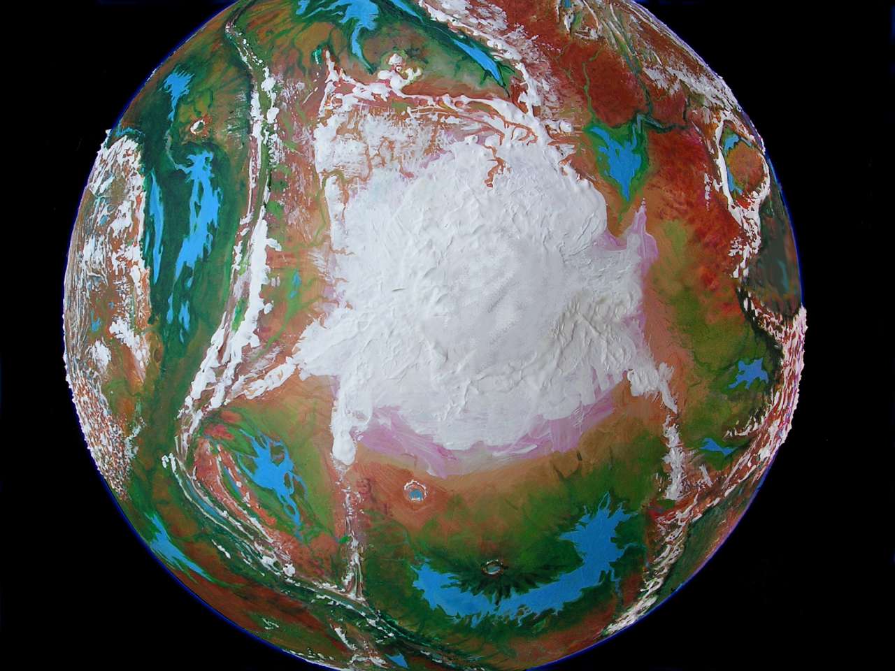
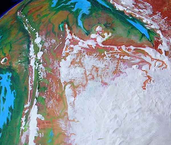
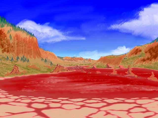
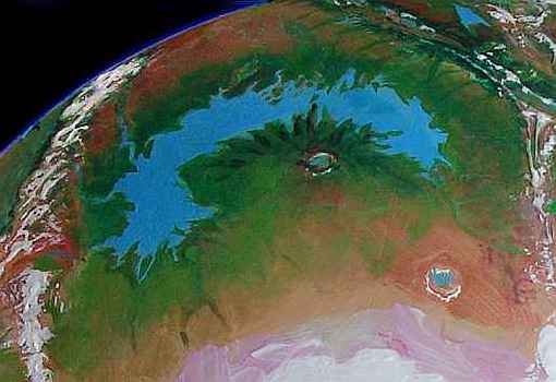
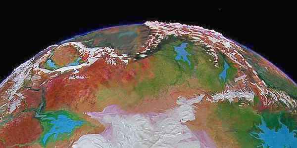
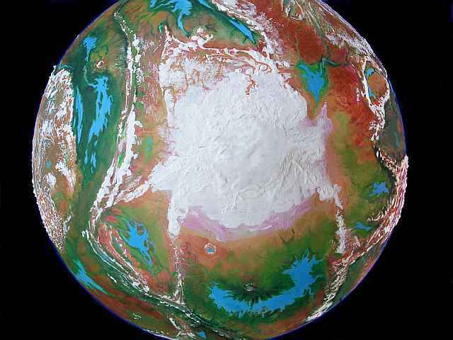
In the orbital photo below, Tharn's polar cap looks big--as big, proportionately, as Earth's, and far bigger than Mars's. That's deceptive! This shot was taken in late fall, after blizzards dusted half the northern tundra. In some spots autumn dust storms have tinted the snowpack pink or salmon; these darkened areas may well warm enough in the low sun to melt again before true winter sets in. The war between red and white is most obvious in the dappled upper left, where valleys are still snow-free, but this patchy skirt of mere winter snowfields on tundra goes all around the ice cap. Though uninviting now, these plains do sustain lichen and grass in summer--and that sustains whole nomadic peoples.
Terran icecaps generate what are called katabatic winds--not just cold and dry, but relentless gales powered by the steep drop off ice-plateaus two miles high (cold air is denser, right? It wants to drop.) While cold dry winds often blow off Tharn's ice cap, they're not katabatic (not hurricane-fierce, not constant) for there's no great drop to fuel them. Without that deadly gale, life ventures closer to the ice cap than on Earth.
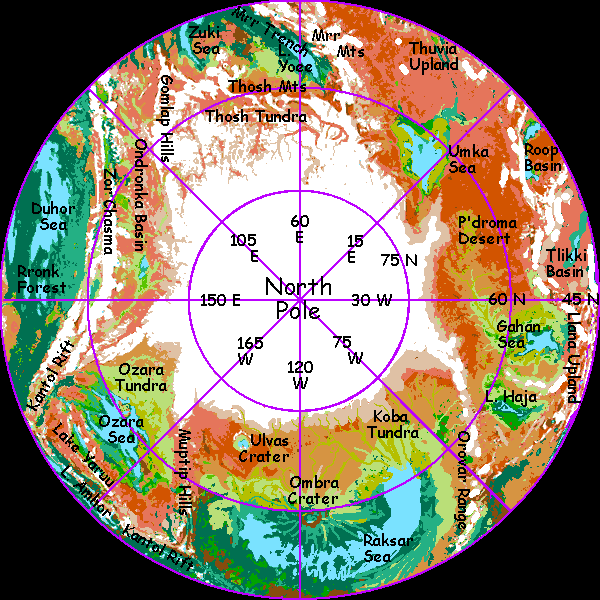
Let's have a look at these subpolar regions. Even for Tharn, it's hard, rugged, lonely country. I'll run counter-clockwise around the ice, starting at the top around Lake Yoee. Tharnians would approve of that starting point, for it echoes with history.
SHOLIKA'S LOPE
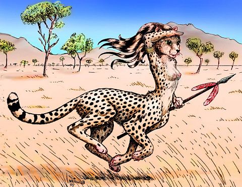
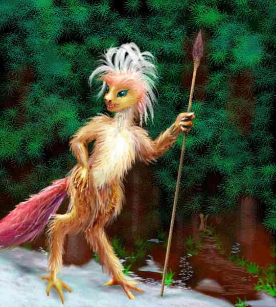
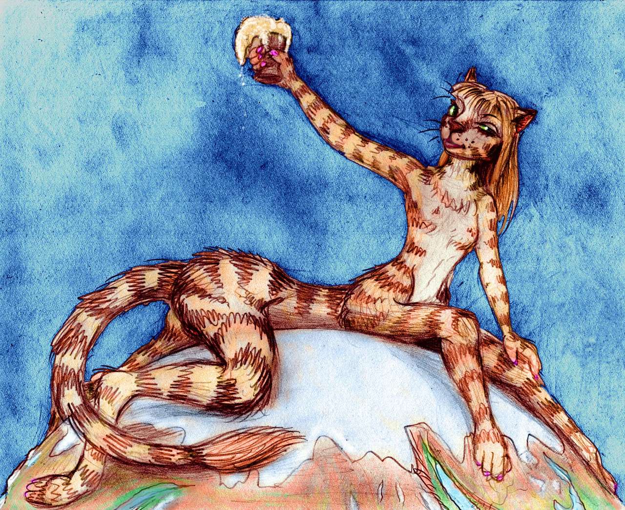
One spring day thousands of years ago (but remember, Tharnian years are short; on Earth, the Tang Dynasty was clearing bandits off the Silk Road, and the Venerable Bede was young) a traveler named Sholika was visiting Lake Yoee here in the north. She was a centah, a native of the tropical Shif Shif Veldt; no verifiable portrait of her survives, but the sketch to the left is typical for the region: a lightly built centauroid with either stripes or spots (accounts disagree; but then you'd get pretty grubby walking round the pole too), and a feline itch for exploring. Sholika certainly had that itch; she was already far beyond her people's natural range. She may not have realized how far, or what she was about to get into, for Lake Yoee is extraordinarily warm for the northlands, for reasons I'll explain below.
Sholika, like all centahs, loved to run--200 km on a good day (one with low gravity and 48 hours in it. Oh, wait, that's every day on Tharn. Still sound too far? In 48 hours, a Terran wolf can go 150 km in much higher gravity. In short, Sholika was a not an athlete. Now 300 a day...)
But she was unusual for centahs in one way: Sholika was a bit of a boaster. That spring evening, lapping her mulled cider in a lebbird inn on the Yoee shore, it got her into trouble.
On a bet, she set out to circumambulate Tharn, alone.
Sholika realized skirting the pole would shorten her path, and of course Yoee is already quite far north, committing her to the arctic. So she collected what maps and directions she could, put on her pack, and the next morning set out east.
In sixty-seven long Tharnian summer days, she loped around the world. Magellan on foot! We'll retrace her route, to give you some idea what a feat it was.
FROM MRR TO ZOR
Sholika had already come a long way up Mrr Trench, the longest subduction trench on Tharn, and as deep in spots as Mars's Mariner Canyon. At the top edge of the orbital photo (and just off the map) is Lake Mwaa, 1000 km long, a slender lake along the trench-bottom. Mwaa lies in a rainbelt, so instead of the separate brackish lakes common in trenches, Mwaa is fresh, large and deep; its surface is only 2.5 km below datum. That's still so far down that the shores are very warm for this latitude--quite temperate, and densely forested. And not wildwood: fruit- and nut-trees alternate with house-trees, all loving tended by the arboreal, winged lebbirds (sketch below) native to Mrr Trench.
Lake Mwaa drains north into Lake Yoee--Sholika followed the Mwaa River. Yoee's the long lake at upper right in the photo, and the top of the map. Smaller than Mwaa, Yoee is still 700 km long (450 mi), stretching from 57-65 north.
Hmmm. I just noticed my sketchmap is wrong--Yoee is really almost five degrees closer to the pole than I've shown. Sigh! Rather than move all those canyons and tundras poleward, I'm just warning you. Certainly Sholika's maps were no better than this; probably much worse. Early Tharnian cartography, just like Earth's, was trade-based; all anyone cared about were safe routes through an inhospitable world.
The insight that insights are possible by seeing your world whole, in its true proportions... well, I wonder if we've even grasped that yet.
Besides, errors of latitude are understandable enough around Lake Yoee. Lying fully 3 km below datum (10,000' down), Yoee was and is an oasis of warm, mild air in a frigid region; the northernmost woods in the world line its shores. It just doesn't feel arctic. Lake Yoey might better be called the Yoey Sea, as the water's quite briny--it has no outlet and the dry polar air evaporates it, concentrating salts. Local streams from the snowy heights aren't enough for equilibrium; the lake owes its size to the Mwaa River's copious flow.
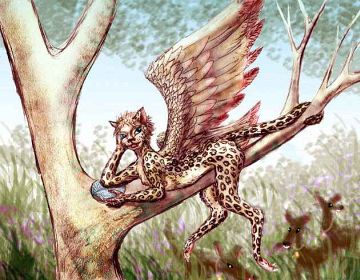
Details aside, Mrr Trench is a warm Terran crack in a continent-size swath of Old Mars. Truly a terrarium; and its denizens can't leave. Lake Yoee is home to the northernmost lebbirds on Tharn (sketch, right); they don't venture up onto Yoee Steppe, two miles above; they can't fly in that stratospheric air.
So poor Sholika, wingless, had to climb the great cliffs on steep paths used only by camaroo traders (sketch below left). We'll be meeting lots of them all over the north. They're as cold-adapted as that fur looks. These shaggy, bipedal cameloids herd flocks on the windy grasslands below the snows of the Thosh Range and Mrr Mountains. At least the conservative ones do; those with an itch to see the world apprentice themselves to a caravan. Camaroos are tireless walkers, and most of what Terrans call "shipping" gets caravaned around Tharn; here, every road is a Silk Road. What maps Sholika had would have been camaroo work; the caravan system was already old.
A few days' lope toward the rising sun led Sholika east from the lip of Mrr Trench to the Zuki Sea---a cool brackish lake 1300 km long and 250 wide (820 by 150 mi), with a convoluted, dark-forested shore. Too high up for lebbirds, too closed-in for camaroos to herd, the Zuki Forest is the home of a species called mops, a bit like huge, flightless, toothy, flashy-feathered ravens, living in carved lodges with totem poles. They trade with thotter fishing villages out on the islands and capes.
Here she was met with raucous amazement, amusement at her expense, and a lot of fermented heath-berry juice at others' expense. Mops like a party and Sholika seemed a fine excuse. This began a pattern that held true most of the way round the world: hospitality despite incredulity. Tharnians, having had to learn to get along with neighbors who aren't even from the same phylum let alone species, generally like strangers; they bring more news and entertainment than trouble. Sholika discovered that her bet for free beer in Yoee had already won her the world.
If she kept moving, credibly moving, and didn't wear out her welcome. At this point, from her journals, it's hard to tell if Sholika was even serious about her quest to circle the globe. More in the spirit of "As long as the drinks are free..."
Beyond the Zuki Forest she crossed a long windy prairie. Grasses flowered, but there were few flocks or herders; prime grazing was still a little south. Ahead lay the slopes of Zor Chasma, a rift valley dotted with lakes and hot springs, stretching nearly pole to pole. Twin ridges flank the main rift; these block the harsh polar winds, making the sea-basins to the south almost temperate. Below these ice-capped ridges, on their alpine slopes and in dark valleys full of low evergreens, camaroos herd their flocks of Woolly Anoxia, the only domestic animals that can bear the cold thin air of the ridges... or the mineralized water of the Rift.
Ugh. Bitter, soapy... don't even taste it. No need. Sholika never came here. Out of her way, and the herders warned her.

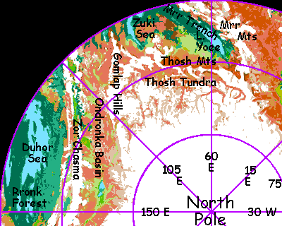
Sholika loped on. North now, where ice gleamed: the peaks of the Thosh Range, 2-3 km high (6600-10,000'). Beyond them lies Thosh Tundra, a hilly region of winding shallow rivers. The orbital photo of the pole that opened this tale was shot after the first autumn snowfall, so the tundra's as dappled as leopard-fur: white hills, snowfree valleys. Some canyons wind right up into the thin polar ice, like Antarctica's Dry Valleys. But in early summer, when Sholika reached them, the mountains were still snowed in to the knees; she didn't consider taking a truly polar shortcut over them to the tundra, though it would have been mostly snowfree and greening quickly... That would mean putting on her four leather snowmoccasins, and centahs hate covering their paws. Losing contact with Mother Tharn? Ugh!
But a few days later, after skirting a cluster of dormant volcanoes hulking over the plain like monster scoops of ice cream, then veering north round the tip of the Zuki Sea--the last woods she'd be seeing for a long while--Sholika had to don her snowmoccasins anyway, when she ran into the Gomlap Hills, a range 2500 km long (1600 mi) but only 2 km high (6600') that forms an icy arm of the polar cap reaching south almost to the Zuki Sea. The Gomlaps are unavoidable, and nearly as glaciated as the Thosh Range. But Sholika found an ice-free pass (if not snowfree this early in summer) through to...
THE ONDRONKA BASIN
The sinuous Ondronka River collects milky water from many tributaries off Thosh Tundra and the ice cap to the north, winding east and cutting through the Gomlap Hills; Ondronka Gorge, though scenic, was well north of Sholika's (and our) route.
But a few days later she met the river winding southeast to Lake Ondronka, a brackish little sea 200 km long and half as wide (125 by 60 mi). Around the lake, for 500 kilometers in every direction, stretches cold, windy, but fertile tundra. Here and in Thosh live mamooks, huge lichen- and grass-eaters who look nothing like mammoths but fill a similar niche--except for the tools, and fire, and stories, and rock bands (not what you think: bands of mamooks bang complex rhythms, rock on rock. Well, boulder on bedrock. Valleys shake.)
Sholika had heard they're nice folks, but as her journal says, "I prefer not to get squashed." Sholika loped on.
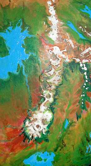
On the left edge of the orbital photo above, well south of the tundra, is Rapass Crater---an impact basin 120 km (75 mi) across. The shady faces of the rim have glaciers, but the sunny faces and the deep crater floor are the warmest places within 1000 km. It's an ecological island, and a cultural one: a complex four-species society has settled its microclimates. There are even a few centahs. A fascinating place, full of inns where she'd be the life of the party (always important to a centah) but far out of her path, and over the barrier of Zor Chasma too. Sholika repeated to herself (and her journal) that running supposedly keeps you warm. Sholika loped on.
To the northeast (lower left edge of photo) is the Duhor Sea, 1000 km long and 300 wide, dotted with wooded islands where thotters fish. A bit further east are the four Rronk Lakes, 150-250 km long (off edge of close-up; see big photo). Around them all stretches Rronk Forest, the largest boreal forest on Tharn. This cool evergreen strip runs 7000 km from Rapass Crater east all the way to the Sea of P'tang.

In Rronk live elaffes--not their name for themselves (an unpronounceable rumble), but a descriptive trade-term for these huge quadrupeds with long necks and prehensile trunks. Silviculturalists, they've bred fruit- and nut- and edible-leaf-tip bearing trees; far more hospitable than Earth's dark northern forests. Sholika's food panniers were getting ominously light by this point and she hadn't seen anyone for two days, so she was sorely tempted.
South of Rronk Forest is Dejah Upland. The Drampe River is the main stream draining northern Dejah. C-shaped Lake Drampe, 190 km across (120 mi), collects streams in the alpine upper basin; the Drampe then flows north off Dejah Upland and bends sharply west through Rronk Forest to drain into the Duhor Sea. The river's 1900 km long (1200 mi), though its source and delta aren't far apart! The upper basin is populated almost exclusively by mamooks; it's too cold for elaffes. Or for centahs! Sholika didn't even consider visiting this region, it's so far south; I mention it only because in many ways it's "an Arctic away from home", like our Tibet.
But the lowlands north and east of the Drampe were another matter: a long forest corridor tended by elaffes. A definite possibility...
KANTOL RIFT
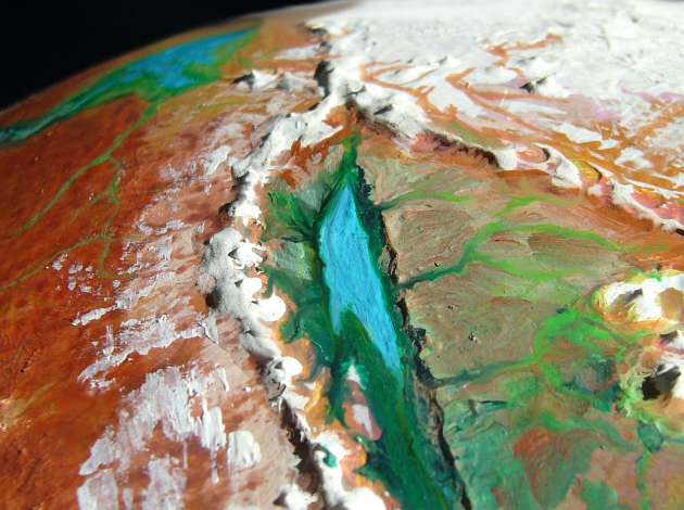
Once Zor Chasma bends east and acquires glaciers on its ridges, it also acquires a new name: Kantol Rift. Geologically it's the same: a spreading zone for new crust. On Earth, it'd be a mid-ocean rift; here it's exposed. Kantol snakes east, north of Dejah Upland, the Sea of P'tang, then Thoris Upland, and then bends south into the temperate zone again. As the coldest of the rift zones, not only do Kantol's twin ridges sport glaciers in spots; its central rift valley is largely forested, not desert or savanna as in most rifts. Sheltered from the polar winds by the ridge, this long valley has some of the northernmost woods in the world.
Lake Amhor breaks up the monotony of the rift-floor forest strip. A narrow sea 500 km (300 mi) long, Amhor changes color seasonally; the bottom seethes with hot springs and tufa towers; its mineral balance is peculiar and its bacterial population unique and quite dense in summer.
There's a large surface die-back in winter, but Lake Amhor never freezes. The nearest Earth equivalent is Lake Baikal in Siberia, though that could be said of half Tharn's riftlakes; and the anology's not that close, for freshwater Baikal's a mile deep, while brackish, steaming Amhor averages less than a hundred meters.
It's a fascinating sight, but no one lives here. Gleaners of mineral salts visit, but thotters go bald if they swim in that stuff. Nor is fishing an option--the lake's life is all gag-me bitter and emetic. The largest and most advanced creatures are spider-stars--five whiplike arms, rudimentary eyes, under a kilo (2.2 lbs)... Unimpressive, but Tharnians probably evolved out of lakes like this, and creatures like this.
Because Sholika didn't see any locals during this part of her trek, no one knew to warn her that this long wooded ribbon inside the rift was a poisoned Siberia, not a tame elaffe orchard. A crooked line of ink saved her life: one of her crude maps implied, correctly, that the Chasma eventually bent south. She guessed it might lengthen her journey round this hemisphere by two weeks, so she reluctantly decided to stick to the dreary northern plain. Good guess! I doubt she would have survived in the Rift. But she read the roadmap! So Sholika loped on.
In the end, another snowy spur of the northern ice started forcing her down toward the Rift. The tundra narrowed to a long, windy, ice-free pass. She had to dance around a few snowdrifts, but stayed bare-pawed. After a long day's trek through dry barrens, eating old snow, came another spur, a low pass... Streams started flowing her way, down into...
OZARA BASIN
Just north of Lake Amhor and Kantol Rift is the Ozara Sea, a shallow, brackish body 800 km long (500 mi) in the center of a broad tundra basin. Ozara is choked with low islands; the complex, marshy shore looks from above like a cartoon of a dead sparrow. A few thotter villages are the only permanent settlements; Ozara is exposed to the cold dry winds off the polar ice. Still, nomadic camaroo guide flocks in the grasslands south of the sea.
So Sholika, led southeast by the pass, found herself back in civilization--the fringes at least. She told her story, interrupted by endless variations of "What kind of critter are you, anyway?" Remember, her species was as alien to the locals as she would be to you: a slim feline centauroid among shaggy kangaroos. Life on Tharn emerged from more than one tiny sea, finding divergent solutions to the problem of land locomotion.
One aspect of her species you'd find quite Terran. Sholika was a cat; cats are curious. She heard of a great mamook festival, and for a change, it wasn't much off her path. She had to go.
North of Ozara Sea is mamook country. Even in summer, the winds can pick up during the long afternoons. While mamooks don't need warmth, in summer they need something else: good acoustics. They need a site for a chong-ma: a music festival, a competition, and a marriage market all in one, where mamooks of both sexes try to impress potential mates with roared ballads and rock-drumming stories, composed and mentally rehearsed all the long dreary lichen-eating winter. And for a chong-ma, Ozara is just too windy and marshy.
But the Hulam Mountains break up the south, sheltering forests from the polar winds. The Hulams are really three ranges 3-4 km high, paralleling the Kantol Rift for 1000 km (625 mi). Between the North and Central Hulams lies long Lake Yaruu in a subalpine valley. Sheltered from the winds, the valley of the Yaruu is ideal for a great chong-ma.
Sholika went. A brave act, knowing so little; give her credit. Her journal is the first outsider account of a chong-ma. She was stunned. There were nearly two hundred of these gigantic people; that's five thousand metric tons of flesh. When they danced, bedrock shivered. She even drummed and chanted herself, telling her journey. Of course she did it in her slangy southern dialect of Trade Camaroo, but a fair percentage of mamooks (despite their subsonic-bass accents) knew this common trade-tongue; they're fair linguists and they get around. You would too, with a twenty-ton body you need to feed in sparse country, and a five-kilo brain that needs feeding of its own. Mamook culture may be oral, but it's very oral. Languages and wordplay, poetry and song are vital to them.
So the mamooks appreciated the hubris of this furry pipsqueak on a slab, and honored her mamookian style. They awarded her the prize for Best Liar (it took a while to explain that was a compliment) and gave her small snacks that fed her for the next thousand miles.
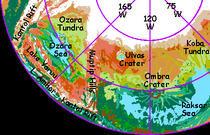
Her journal's account of how she outsang all the mamooks in the world is today paraphrased to great comic effect by mamook storytellers, for she naturally assumed it was a great gathering. On her scale, or ours, it was. But in fact the Hulam chong-ma has always been a minor affair, strictly local; for over the Muptip Hills to the east, the largest chong-ma in the northern hemisphere is held in Ulvas Crater; a much bigger venue with cliffwalls that focus the sound. Poor Ozara! It's in a cultural as well as ecological shadow. The Raksar Basin is just plain richer...
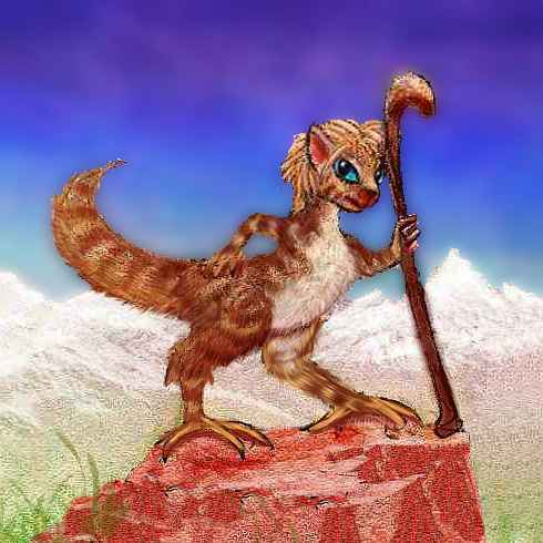
The Yaruu Valley, though, is fairly mild, and as diverse as Ozara Basin can offer. Civilized, as I said. The Valley's a cool, green patchwork of subalpine meadows and dark evergreen woods; an oasis for mops (right) and camaroos as well as mamooks during festival. The shores of Lake Yaruu, some 400 km (250 mi) long, are also home to some of the northernmost thotters in the world. Sholika writes that she felt as if they were old friends. A species of folk she knew! For her the next stage of her journey was easy, padding along the sunny north shore of the lake, swimming in the chilly but bearable lake (not all cats hate water; and a chance to be clean couldn't be skipped).
The idyll ended, of course; this is the north. The long lake ended, and Sholika followed the Yaruu River upstream, climbing into the Muptip Range, a north-reaching spur of the ridges flanking Kantol Rift. In a Terran sea-basin the Muptips (like the Hulams before them) would be dubbed a fracture zone. They're rugged, rise up to 2500 m (8,250'), and run about 2000 km (1250 mi) north, dividing the Raksar and Ozara Basins. Even mamooks only visit to graze in summer; the heights are bare and windy.
Near the summit, Sholika had to wear her boots for two days. I believe I mentioned centahs hate that. She certainly did. Her journal is full of whining. Blisters and cracks. Her lake vacation had made her soft. But she had a bet to win! Sholika limped on.
And, at last, down. Into a better world.
RAKSAR BASIN
Beyond the Muptips is the much warmer, greener Raksar Basin. The U-shaped Raksar Sea is nearly 2000 km long (1200 mi). It lies between the towering Orovar Range, the low Muptips, Kantol Rift, and the polar tundra. Raksar's shores are evergreen forest, one of the greatest in the north; an elaffe homeland, especially on the warmer south shore.
The north coast, where Sholika ran in her circumpolar journey, is rugged; the splash apron of Ombra Crater forms a broad peninsula, the center of Raksar's U-shape. Ombra's rays of debris form straight, radial capes and "fjords" along the north shore, 160-250 km long (100-150 mi); stray mountains of debris also form the Brako Islands, which nearly divide the Sea here. The Brakos stretch hundreds of km, though you need a good map to tell which "capes" are really islands. Narrow Ombra Strait (only 10 km wide--6 mi) leads from central Raksar into Ulvas Arm, the western third of the Sea. To the south far wider Brako Strait (30 km/20 mi), also leads into Ulvas Arm. Most of the people here are mops, well adapted to boreal forest, but thotters fish the fjords and islands. And trade; Raksar Sea is big enough to be a useful shipping route.
Let's take a side trip north here; Sholika did. Soon you see a mountain wall ahead, unbroken, forested until near the top. Up the long slope, an all-day climb--and I mean a Tharnian day. And then the world drops away! The vast round pit below you is 3 km down; 10,000'.
This is Ombra Crater, one of Tharn's largest, ruggedest impact features: 190 km wide (120 mi). A lake fills the crater's floor below a ring of ridges snowcapped even in summer. It's a little world of its own, sheltered from the polar winds; the north side, facing the sun to the south, feels almost temperate. And the crater floor, a kilometer below the Raksar Sea, is a pool of denser air, trapping heat. It feels like 2000 km to the south. A dense population of thotters, mops and camaroos live in close proximity here, forming a hybrid culture. There were no elaffes, then or now, though they'd find the crater floor paradise; but the walls are too high, the air too thin for them to comfortably climb. Elaffes evolved in a trench deeper than Lake Yoee; while they've more or less adapted to the plateaus above, it's as if they've settled Tibet; they wind easily and can't climb more than low hills.
A thousand km (600 mi) northwest of Ombra is Ulvas Crater, an equally huge impact scar, but shallower, with walls a mere thousand meters high and a sediment-choked floor with a shallow lake. It's no mystery why Ulvas is so flat: ice-bearing strata probably melted to mud on impact, for Ulvas lies in the polar tundra. Despite their different depths and appearances, Ulvas and Ombra are the same size and age; they may be simultaneous scars from a chain of comet strikes. If more fragments did hit, the polar ice has hidden the craters.
Cold and almost treeless, Ulvas has no permanent residents; but every summer, several thousand mamooks gather for the largest chong-ma in the north. They fill the north end of the crater, where the rim blocks the wind, drumming and chanting the year's compositions. The plain thunders for miles. But only for six days. Tharnian days, it's true; nearly two weeks, Terran time; but by the time Sholika had reached Raksar Sea it was over.
Besides, she'd performed in a great chong-ma; why visit another? Couldn't be bigger than Hulam! "Locals", she wrote, "do exaggerate." So Sholika loped on.
Over that towering rim, out of the pool of air and warmth, back into that Nordic forest. The next day, and the day after, a steady trot east by a straight little stream between two near-parallel ridges: rays of ancient crater debris, down to the shores of Koba Arm, where the Raksar Sea bends north. These shores are low and marshy, but still backed by forest, except for the Koba Delta at the north end of the Arm: here the marsh fades into treeless tundra, and the mop villages end. So did the free food, and her chance to tell her story. But she had a bet to win. Sholika loped on.
Past the last marsh, she bent south again. She had better maps now, courtesy of Ombra University, and knew a tall mountain range blocked her path due east...
THE OROVARS
The Orovar Range is a chain of huge shield volcanoes, like the Hawaiian chain without their cloaking sea...or the volcanoes of Mars, for the southern Orovars rise 12-16 km (40-50,000'). Mount Gholit, at the southwest end of the range, resembles Olympus. The hot spot creating the Orovar chain is presumably under it, but it may be slipping further southwest, and will eventually build other peaks, while Gholit, its fires quenched, slowly erodes down to merely Himalayan height, like the other Orovars. Indeed, it's already happening; under its southwestern shoulder, lost in the glare of its icefields, a few cones already rise as tall as Fuji, Ararat and even Denali.
All the peaks, being above most of the atmosphere, are nearly bare rock; monstrous calderas yawn fifty miles wide in utter silence. Not a bird, not a grassblade. It really could be Mars. Even the Orovars' shoulders above 8-10 km are virtually dead. But down around their waists, 5-7 km up (say, 20,000'), mamooks browse lichens and grass, followed by camaroo in the alpine meadows 4-5 km up, then a ring of mops in the cool evergreen forests at 3-4 km, and so on down their foothills--half a dozen species in concentric contour-belts. These foothills and the rolling Shental Valley to the southeast are rather culturally innovative given the sparse population, because so many species with different habitat-needs live so close together.
As with the Hawaiian Chain or the Tharsis volcanoes, there are passes between giants; it's not an unbroken mountain wall. Sholika in her great journey round the pole passed north of the highest peaks, from Raksar Basin east through a winding gap "only" 3 km high. By this time, five-eighths of the way around Tharn, it was late summer; snowpatches all around, but the caravan trail was ice-free and many of the alpine meadows were green. Sholika loped on, down into...
GAHAN BASIN
She came to the foot of a long lake stretching south out of sight: Lake Haja, some 700 km (450 mi) long, though only fifty wide. Haja's treeless shores are marshes where thotters fish; camaroos herd flocks anoxia in the surrounding steppes. Thin woods huddle in sheltered mountain valleys south of the lake, supporting small mop villages; but in the north, where Sholika passed, away from the lake, it's just tundra. No one but mamooks, and most of the time, that means no one at all.
Four days (as the centah runs) further east, round the north end of the snowy Haja Range, the lake has a big sister: the Gahan Sea. Gahan is fully 800 km long (500 mi), and much wider than Haja. It's a few degrees further from the pole, too, and its wide sheet of water humidifies the cold dry winds from the north, so low arctic forest lines its southern shores; small towns dot this coast, a mixed society of mops, thotters, and camaroo. But even Gahan is nearly treeless in the north, except a few in towns, planted and sheltered from the winds.
P'DROMA DESERT
Northwest of the Gahan Basin, a vast tundra sprawls for 1600 km. The lower stretches of the Gahan River, though cold, windy and treeless, support lush grasses--and a (relatively) dense population of mamooks along with some camaroo. But the upper valley slowly grows higher, colder and drier, until it looks as stark as Mars--red rocks, tiny snowdrifts, and wind. (Still, dear Terran readers, remember--despite appearances, this is not Mars. Even this wasteland has 20 times the air pressure, only a few per cent of the hard radiation, and far more warmth than Mars.)
This long red stretch is the P'Droma Desert. It's a mamook name, for only those huge, well-insulated lichen-eaters can survive here. Occasional camaroo caravans do pass through; travelers from northern Mrr Trench or Zor Chasma to the Barsoom Basin take a polar route, much as a San Francisco-to-Paris flight on Earth skirts the pole. True, walking every tedious mile through these grim regions is different than merely cruising above them; but on Tharn, longer, low-latitude routes are equally difficult--great uplands stand in the way, with just as much snow and even thinner air and harsher radiation.
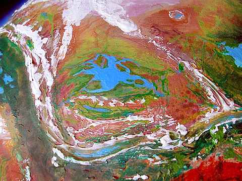
Oh--remember this orbital photo was shot from over the pole looking south. Haja and Gahan Lakes are on the right with Llana Upland on the horizon; the P'droma's dead center, with the Umka Sea to the left.
Here Sholika, in her famous circling of the north pole alone on foot, made an equally famous decision: to cheat. Famous because she promptly undid half of it! She had an unlikely stroke of luck: a caravan planned to head east the day after she arrived. I suppose it wasn't that extraordinary; such crossings have to be done during a narrow window in late summer and early fall (which, by now, it was); mountains at both ends need crossing before winter snows block the passes. Sholika had heard too much in town about the rigors of the P'Droma, and signed on to ride across the desert. So much for alone, so much for on foot!
The first day out, she couldn't take the pace. So slow! She got off her stocky bipedal cameloid mount, and raced ahead. And back. And around. Sholika became their apprentice scout and messenger, able to run twice as fast as any camaroo, mounted or not. And eager to; she chafed at the leisurely pace.
But Sholika had the good sense to keep half-cheating; while she scouted alone most of the day, she returned to the caravan each night. At first this hardly mattered, but as the prairie rose into tundra and then the true arctic barrens, food grew scarce. The snow was full of dust and bacteria, staining it lurid pink. Not good to drink without boiling. Though this leg of the journey slowed Sholika to a crawl, it probably saved her life.
Caravans across the P'droma can (in a good summer) graze for fodder; but just as often, dust storms or blizzards tie them down for days. Wise caravan-guides insist that pack animals carry their own fodder. In a bad year, caravans reaching the shores of Gahan or Umka look like living skeletons... if they make it at all.
As the land begins to drop, the P'Droma Desert fades back into tundra ringing the Umka Sea.
UMKA BASIN
The Umka Sea is the northernmost large sea on Tharn. 700 km (450 mi) across, it's cold, marshy and brackish, but still--it's water, and as always on Tharn, life congregates around it. Umka's coastal flats are a major meeting-ground for the nomadic mamooks, partly because no other species shares its limited resources. It's not the severe climate--camaroos could survive here--but the isolation. Thuvia Upland to the south, the Mrr Range to the east, the polar cap to the north, P'droma Desert behind us--all are equally forbidding. Occasional camaroo caravans follow the rivers, but Umka is the closest thing to a unispecific region on Tharn.
Do I make Umka sound grim? Not in summer! At the solstice, the north shore of Umka comes alive. Mamooks from all over gather for one of the north's largest chong-mas.
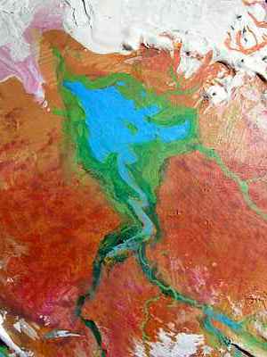
Those pink areas northwest of the Sea are a Tharnian oddity I've mentioned before, but on a huge scale here. The prevailing winds are off the polar cap, but when a dry "storm" rolls in off the P'droma Desert, fine red dust drops on the ice. This can create a salmon-colored stain. But the unnatural pink you see is a further step: bacterial staining. Anyone in sunny snow country where pits develop in melting snowbanks has seen patches and streaks of such bacteria, but on Tharn these colonies, nourished by the dust, can run for miles; visible from space. Indeed, I've often wondered if some of the vivid colors in the "topo terrains" near the poles of Mars are bacterial (admittedly, any bacteria there face radiation and cold much worse than Tharn's. Even the P'droma.)
On the south shore of Umka is the Yamfit Delta. The Yamfit is probably the longest river on Tharn. The West Yamfit rises in the arcuate Roop Mts at the head of Otz Trench complex; the East Yamfit, in the long parallel ridges of central Thuvia. Both branches of the upper Yamfit are alpine; only the lower stretches near their confluence and in the Delta have boreal forest. Caravans all come this way and camp here in the delta, taking advantage of its wood, water, fish and salt.
Other rivers feed the Umka Sea; the shallow, braided, treeless Umka feeds a narrow strip of relatively green tundra north of the Sea, before the ice begins. And down from the eastern rim of Thuvia flows the wooded Yoee River.
I hope that name, Yoee, sounds familiar. For up the Yoee River, over the divide, the land drops away into a canyon rivaling Mariner on Mars: Mrr Trench. And standing in that red pass where Sholika did, under a starry indigo sky despite the copper noon sun, you look six miles down into that winding river of turquoise air, and you recognize the lake in its depths. Lake Yoee, home of the lebbirds. You've circumnavigated Tharn. Circumambulated, I mean.
Not that it was that far--at this latitude, a mere 14,000 km (8000 mi) or so. Every year, a few mamooks get mystically called to walk round the world; and a few camaroo caravan leaders do it by accident, if trade calls... and Sholika herself did it on a whim. A bar bet, a boast. Not an organized quest for treasure or empire, not a caravan or expedition, just a stubborn girl out for adventure and free ale.
She had advantages over Magellan, of course. Sholika never feared she might meet savage warriors--who'd kill a stranger?--or fall off the edge of the planet. Tharn's not a planet--just a moon, with curvature so sharp it's obvious even to the flightless. So she strolled around her tiny world in sixty days. Compared with Magellan's heroic, fatal voyage, it seems so low-key, so... petty.
And yet, and yet... if you see Tharn (and Sholika's Lope) as small, remind yourself: no ships, no seas. No, Sholika's not Magellan, nor even Marco Polo or Ibn Battuta. Her quest was harder. They rode; Sholika walked. Walked around her world, on her own four sore paws.
World Dream Bank homepage - Art gallery - New stuff - Introductory sampler, best dreams, best art - On dreamwork - Books
Indexes: Subject - Author - Date - Names - Places - Art media/styles
Titles: A - B - C - D - E - F - G - H - IJ - KL - M - NO - PQ - R - Sa-Sk - Sl-Sz - T - UV - WXYZ
Email: wdreamb@yahoo.com - Catalog of art, books, CDs - Behind the Curtain: FAQs, bio, site map - Kindred sites