Polodona Rainforest
by Chris Wayan, 2005-6
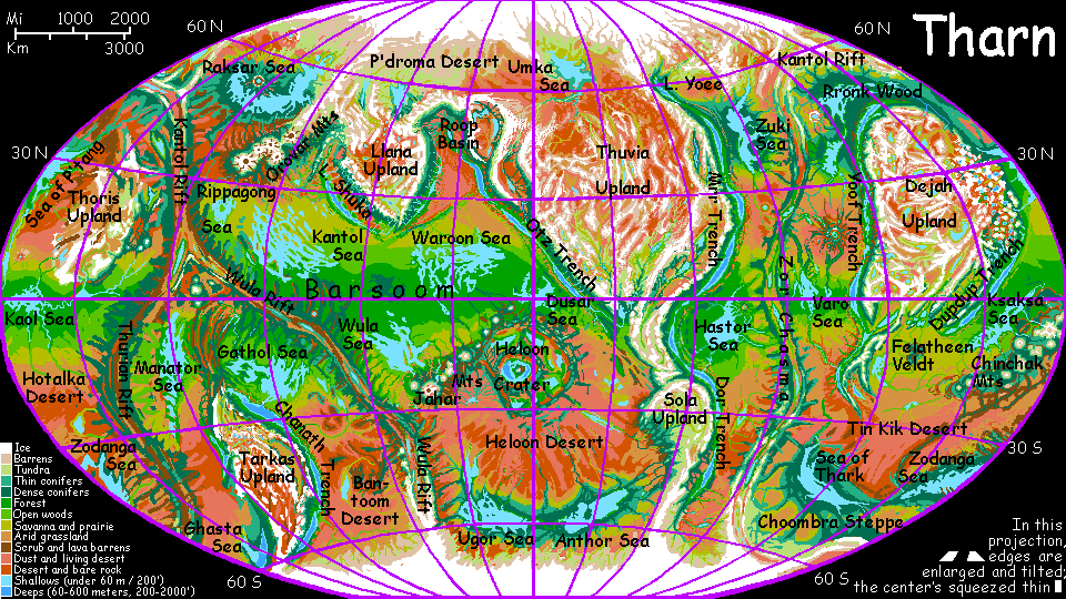
Map, Tharn's homepage, Peoples of Tharn, Regional tours, Geology and Evolution, gazetteer, terms explained. More worlds? Planetocopia!
INTRODUCTION
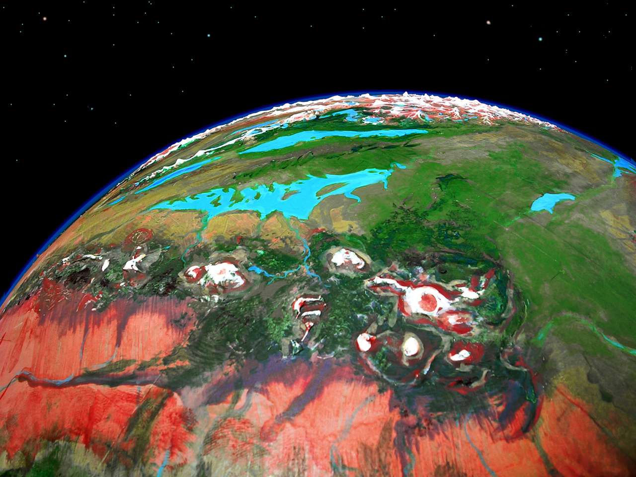
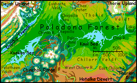
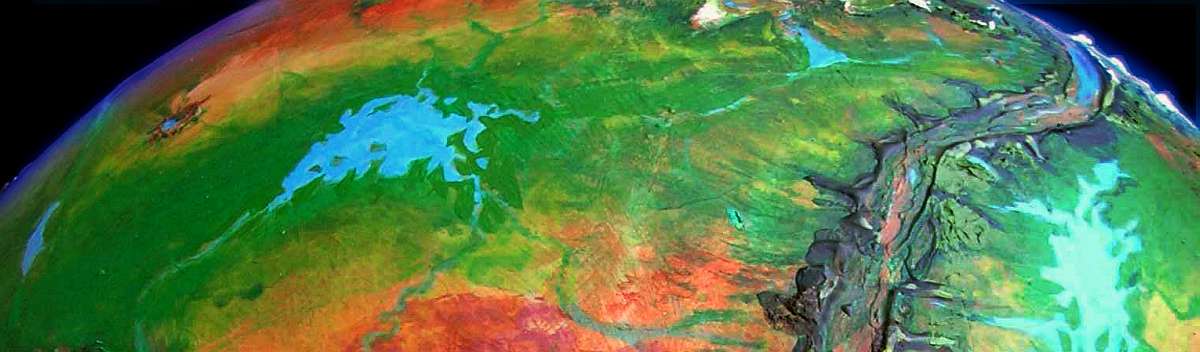
Polodona is the largest rainforest in its hemisphere, covering perhaps 2M sq km (as big as Indonesia or the Orinoco Basin). An equatorial strip--more accurately, a peanut shape--some 3200 km (2000 mi) long, Polodona centers around Ksaksa Sea in the west and Kaol Sea in the east.
Here the equatorial sun heats the moist sea air; it rises and cools, generating clouds and rain--heavy in orbital summer, light in winter. Around the seas, annual rainfall's about 1.8 m (70")--less than a true Terran rainforest. Tharn's year is short, so in one Earth year the woods get closer to 2.3 m (90"), but this is largely offset by faster evaporation in such thin air. It's hard to judge equivalence.
But in the end, it's not numbers that make me call Polodona a rainforest. Tharn's vegetation is used to high evaporation and long dry seasons; year-round moisure in any amount is a bonanza. The soil may be somewhat drier than any Terran rainforest, but Polodona is dense and lush--a jungle.
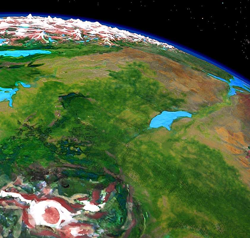
A third invisible sea feeds Polodona--the forest itself. Like the Amazon, it generates its own rain; and storms that stray out of the belt are trapped by the immense Chinchak Range in the south and Dejah and Thoris Uplands in the north. The water returns as snowmelt. Polodona is its own closed world.
Indeed, this is a big hidden factor all over Tharn--plants must conserve water, but minerals from the extensive deserts spread as fine, invisible dust, balancing soils and fertilizing seas. Our soils are much spottier, for forests lock minerals in and our wide seas damp down dust transport. Thus, heavy rains can leach soils, while our open seas are often mineral-starved biological deserts. There's such a thing as too much water. Dry worlds have their subtle advantages!
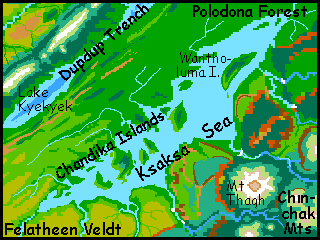
WEST: THE KSAKSA SEA
The south shore of Ksaksa is famed for its scenery. The Chinchak Range is a terraced mass of lava flows, now heavily forested (at least the first few miles up--the peaks are 30-50,000' high). Rivers on these high terraces drop, meander, and pool, only to drop again, until they reach the sea lapping at the mountains' feet. The largest falls combine the sheer height of Angel Falls with the breadth and volume of Niagara or Iguazú, up to a kilometer wide and high. Literally unearthly--and not to be missed.
The population's diverse. Half a dozen peoples share the Mediterranean foothills, often in mixed towns: heat-loving species like the graceful equine veltaurs, scaly bos, and elegant feline centahs; even a few jabbering flyotes. By one-fifth of the way to the top, it's all cool, dense evergreen forests, and most of the residents are squawking, feathery mops and riverine thotters. In the alpine zone above, only chubby camaroos and huge mamooks remain--the only Tharnians able to breathe such thin air. Even mamooks avoid Mount Tsol and the other caldera rims; those near-Martian heights are quite unbreathable, even for them.
Silence and stars at noon...
The Ksaksa shore itself is mild and fertile. The northeast is unbroken forest full of bos. The southwest gets less rain, but still enough for patchy woods near the sea, opening to a huge savanna, Felatheen Veldt. Populations here too are mixed: bo, thotter, centah and veltaur.
The Chandika Islands and Ksaksa's convoluted northern shore are full of shallow sheltered bays where thotters raise waterlilies for their seeds leaves and fruit, giant reeds for fiber and sweet pith, and parru (a semiaquatic dinosaur) for their rubbery eggs. To the east, the long straight coasts of Wantholuma are less conducive to aquaculture; fishing dominates.
Inland, low rainforested ridges run hundreds of km. To the north, these slowly mount and crack into scarps; parallel streams run along straight canyons. Curiously, they're at right angles to the slope, as the land starts to drop toward Dupdup Trench, 3 km deep. In fact they're not water-carved canyons at all--the Dupdup Fossae are cracks opening in the Polodona Plate as it bends down into the trench to be swallowed. Such parallel hills and cracks at the edge of a trench are common on both Tharn and Earth--but ours are all under miles of water. It looks superficially Appalachian--long wooded ridges with a few gaps where streams cut through to the next long valley. It's culturally Appalachian too: travel is hard and each little valley is isolated, inbred. Many of these bo villages have no residents of other species; some have never even seen a non-bo. The only people in their little world! Different from all other species, they tend to assume people everywhere will have bo instincts. Real hillbillies!
Almost as backward as us.
MIDDLE: THE CHEPSILLO SEA
The Chepsillo Sea is a misnomer, though everyone in the region calls it that. Chepsillo's just a modest freshwater lake, 450 km long and 220 wide (280 by 140 mi). Its source is high in the huge, volcanic Chinchak Range to the south. The Chepsillo River flows north through Polodona Rainforest to the lake, then winds north through steadily drier savanna and near-desert to the Sea of P'tang.
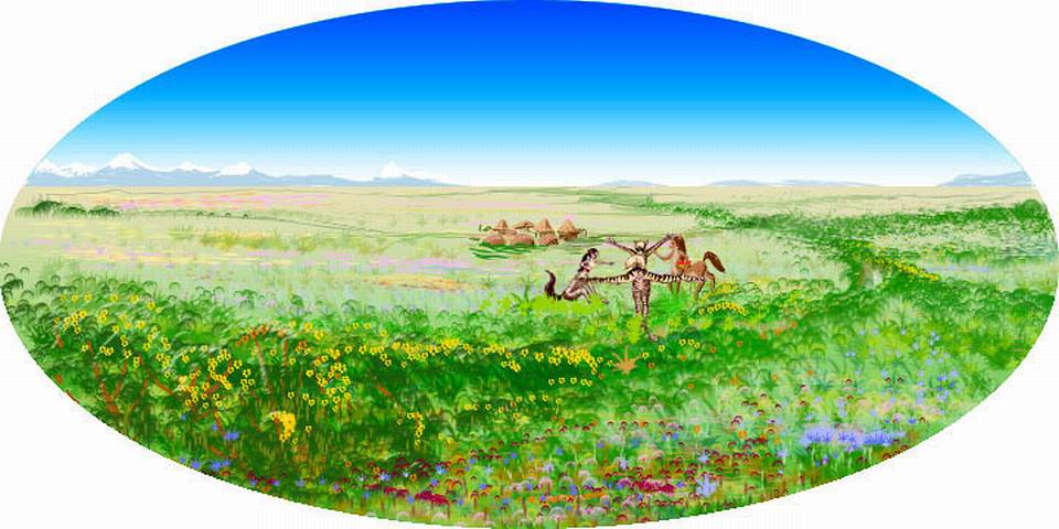
West of the river and lake is Lushanta Veldt, a warm, rolling plain 1000 km (600 mi) wide, dotted with trees that thicken to groves and open woods in the south--the fringes of Polodona Rainforest. Across Lushanta to the west (on the horizon in the orbital photo) is the lake country of Dupdup Trench. Dupdup is flyote land; at least they're the only flying people who've settled this air oasis. Veltaurs, lobbras and thotters also live here, but being wingless, they enjoy only the dense air's secondary benefits: a stable, hot climate, no sunburns, invigorating air, fertile farmland... Lebbirds and wingbok could certainly fly here too, but they haven't yet reached Dupdup Trench. They may be a long time coming--it's 2000 km over jagged mountains to the next oasis where people can fly.
EAST: KAOL SEA
Eastern Polodona has no boundaries--it's a featureless basaltic plain, essentially a dry sea-floor, with only a small sea pooling in its low point. It's about as pure an example as you can find of a climate created by latitude and convection cells alone, with no boost from topography. No mountains shield it from the deserts to the north and south, or snag storms from elsewhere, wringing rain from dry air by forcing it up; it's just an equatorial strip where the air, humidified by the lucky placement of a sea and heated by the tropical sun, rises to generate rain. The forested strip fades gradually into open woods, savanna with groves, dry veldt, and finally desert around 15 degrees north and south: a Sahel sandwich! I had my doubts whether such an equatorial rainbelt could survive, fed by such a modest sea; but the Mars probe in Terra Meridiani suggests it can. A wetter equatorial belt becomes as inevitable as the deserts flanking it. Latitude trumps all! (If, that is, your world has Earthlike convection loops: tropical, temperate, and polar. Despite great differences, ancient Mars probably had them; so Tharn, hybrid of Earth and Mars in so many ways, will too.)
The lushest woods huddle round the Kaol Sea. It's a shallow, irregular, slightly brackish, rather tannin-stained but still quite drinkable lake some 700 by 500 km across (450 by 300 mi), with a convoluted coast and many small islands, all densely forested. Thotters fish from these capes and islands and raise parru in the marshy deltas of the Omp and Chilorr Rivers, at the east end of Kaol.
Eastern Polodona Wood is modest compared to the huge savannas north and south of it. In terms of population and culture, the greener parts of Thoris and Chilorr Veldts easily rival the Kaol Sea; veltaurs, lobbras, centahs and bos flourish in mixed villages. Both fade slowly into semi-arid prairies, then desert.
Only to the east is there a true border: the Thurian Rift, a crustal spreading zone like our Mid-Atlantic Rift. Laid bare by Tharn's sealessness, Thurian's sinuous ridges and jagged, transverse fracture zones rise 3 km (2 mi) above the plains, looking like a mad giant's railroad. Down in the central rift valley, hotsprings and mud volcanoes simmer. Such desert pools are bacterial paradise, but hell for anyone else; the rift itself is nearly uninhabited, though some mop villages nestle in the greener canyons of the fracture zones.
POLODONA CULTURE
As in Terran rainforests, most of Polodona's life is in the canopy, 50 meters up. Fliers abound, but in Tharn's thin air, none grows larger than a parrot; intelligent, but not people. Nor are any of the arboreal nonfliers (surprisingly, on this world so rich in intelligent species); several are as large, bright and adaptable as apes, but the only people we'd recognize as such are the peculiar-looking bos--and they're a forest-floor species not even native to the rainforest.
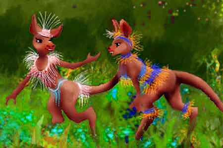
Bos evolved in savanna and open woods, browsing mostly at ground level for fruit, grubs, leafbuds and roots. They invented agriculture at least 20,000 years ago and switched over more completely than humans; bos are omnivores, but need less protein than humans. Bos rarely hunt, but do stream-fish with lures.
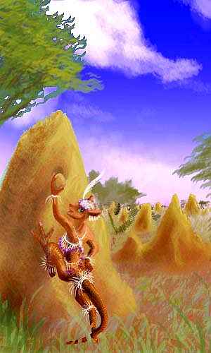
Bos have domesticated a sort of termite, mainly for its "honey", but also to eat--they're rich in protein, fats, and resins said to discourage Tharnian parasites. In the paint-sketch below, a bo is popping the clay "cork" out of a termite mound to remove honey and a few larvae for you to try. They taste like pine nuts. Squirmy pine nuts. Go on. You first.
In recent millennia bos ventured into the deep rainforest. Early populations were low and migrant, depending on slash-and-burn agriculture. But trade from the far hemisphere brought the seeds of a dozen species of fruit- and nut-trees developed by lebbirds and their own mentors, elaffes. Once they got the concept of multistory silviculture, bos started breeding native Polodona trees for high yields of fruit and seeds. Bos aren't truly arboreal, but are decent climbers--their birdlike feet and long tails can grasp treelimbs, freeing the hands to prune or harvest. Modern bo silviculture isn't as pure as the lebbirds'--bos still live on the ground, planting herbs in the shade of their trees--but it doesn't exhaust the soil like slash-and-burn farming. Villages can stay put, and don't require a large hunting territory like human rainforest villages; neighbors are close, known, and nonthreatening. Due largely to fine dust and an opposable heel-claw, the perpetual low-grade territorial wars of human rainforest tribes never began.
Despite the bos' odd appearance, their ground-based communities, with their round thatched huts and toolsheds, look far more human than, say, a lebbird tree-city.
The bos aren't alone in the wood. Nearly a million thotters live in Polodona, fishing and raising parru for their rubbery eggs. The largest population's on Wantholuma Island in the northern Ksaksa Sea, whose marshy coasts are ideal for parru farms; but all the Chandika Islands, and many of the capes and bays of the Kaol Sea, are heavily farmed as well.
Thotters and bos find each other funny-looking--hilarious in fact. It doesn't stop them from trading extensively. Many of Polodona's streams and lakes are snowmelt from the high Chinchak Mountains, and are surprisingly cold for an equatorial region.
Fish, fish eggs and parru eggs are all loaded with polyunsaturated oils. Bos are convinced they promote longevity. It's true that thotters live up to a Tharnian century (perhaps 80 Earth years), though that could be their extremely active lifestyle--and swimming is safer than climbing trees! Tree limbs fall, and so do bos; few die of old age.
Two more species live on the fringes of Polodona, where the woods open up; herbivorous veltaurs and lobbras farm small clearings. In this zone, the light rains and invisible dust keep (properly tended) slash-and-burn gardens fertile indefinitely. Thus, as with bos, populations are dense, and neighbors are friends, not rivals for territory. War is unheard of--not that herbivores ever felt the need! We forget how much human wars grow out of our territoriality--and that's a hunter thing.
World Dream Bank homepage - Art gallery - New stuff - Introductory sampler, best dreams, best art - On dreamwork - Books
Indexes: Subject - Author - Date - Names - Places - Art media/styles
Titles: A - B - C - D - E - F - G - H - IJ - KL - M - NO - PQ - R - Sa-Sk - Sl-Sz - T - UV - WXYZ
Email: wdreamb@yahoo.com - Catalog of art, books, CDs - Behind the Curtain: FAQs, bio, site map - Kindred sites