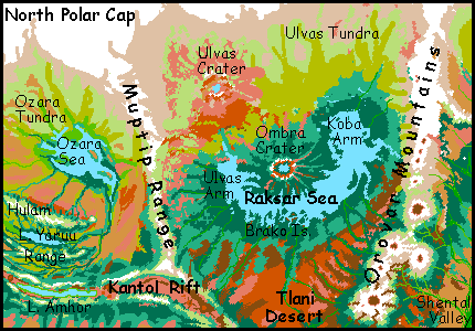
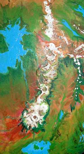
RAKSAR SEA
by Chris Wayan, 2005-6
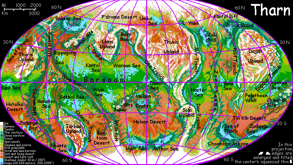
Map, Tharn's homepage, Peoples of Tharn, Regional tours, Geology and Evolution, gazetteer, terms explained. More worlds? Planetocopia!
INTRODUCTION
This region of northern Tharn is quite Siberian: the dry steppes of Tlani in the south, the endless taiga (sparse evergreen forest) around the Raksar Sea, the icy ranges above wide tundras in the north--there are even two huge impact craters, though they dwarf the Tunguska and Novosibirsk meteor strikes, and are far older.
One profound difference: no Arctic Sea to moderate the climate. Siberia, moderate? Sure, compared to Antarctica! Tharn's polar caps are far thinner and less massive than Antarctica's, with much weaker katabatic winds, but they still generate cold dry winds much of the year. Only where mountains or crater walls block the wind does life really flourish, as in the Yaruu Valley sheltered by the Hulam Mts, or the forests south of Raksar Sea, sheltered partly by sheer distance, partly by the sea which remoistens those desiccating winds, and partly by the ridges radiating from Ombra Crater.
Three intelligent species dominate the region, all frost-tolerant and all flightless. That's not a coincidence! There are no deep basins or trenches in the region, so the air is thin. Despite the low gravity, fliers must be fairly small--but small creatures lose heat more readily. The result: fliers no bigger than Earth birds. And no smarter.
The three are avian mops, a bit like kinder, gentler velociraptors, marsupial cameloid bipeds called camaroos, and the dinosaurian mamooks. Near water, you may also find thotters.
Raksar's not entirely bereft of other species. South of Kantol Rift you may meet a few pioneering elaffes and (probably shivering) flyotes. No lobbras have been recorded; they can handle the cold, but not the thin air. The Tlani Desert in the far south almost belongs on another tour, Barsoom Basin perhaps--its only year-round residents, as one might guess from its clicking name, are plains wingbok--drought-tolerant, stunted and primitive.
OZARA BASIN
The Ozara Sea lies in the tundra basin just north of Kantol Rift, west of Ulvas Crater and Raksar Sea. It's 800 km long (500 mi) and half as wide. Ozara's complex coast looks like a cartoon of a dead sparrow. It's choked with low sandy islands. In places, boreal forest has anchored the dunes; in others, the wind moves them faster than trees can grow...
Much of the Ozara Basin, and all of it north of the Sea, is bare tundra where only bands of grass- and lichen-eating mamooks roam. But the Hulam Mountains break up the south, sheltering forests from the cold dry winds off the polar ice. The Hulams are really three ranges 3-4 km high, paralleling the Kantol Rift for 1000 km (625 mi).
 Between the North and Central Hulams lies long Lake Yaruu in a subalpine valley. Hulam and Yaruu are mamook names, for these huge, cold-tolerant people are the only ones to inhabit the uplands. Sheltered from the winds, the Hulam valleys seem ideal for a great chong-ma, a midsummer mamook song-fest. There is a modest one, but strictly local; for over the hills to the east, in Ulvas Crater, is the largest chong-ma in the northern hemisphere. Poor Ozara! It's in a cultural as well as ecological shadow. The Raksar Basin is just plain richer...
The Yaruu Valley, though, is fairly mild, and more diverse. The Valley's a cool, green patchwork of subalpine meadows and dark evergreen woods; an oasis for mops and camaroos as well as mamooks. The narrow east-west lake, some 400 km long (250 mi), drains east then north into the Ozara Sea; its shores are home to some of the northernmost thotters in the world.
KANTOL RIFT
Kantol Rift is a chasma, a sinuous groove flanked by low ridges. From it, new crust is spreading. On Eath, it'd be a mid-ocean rift; here it's exposed, snaking across the orbital photo above. Kantol skirts the north polar cap; when at last it turns decisively south it's called Zor Chasma. The coldest of the rift zones, Kantol's twin ridges sport glaciers in spots; its central rift valley is largely forested, not desert as in most rifts.
The Muptip Range is a low but snowy northern spur of the ridges flanking Kantol Rift. In a Terran sea-basin the Muptips might be dubbed a fracture zone. They rise up to 2500 m (8,250') and run about 2000 km (1250 mi) north, dividing the Raksar and Ozara Basins.
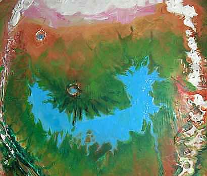
RAKSAR BASIN

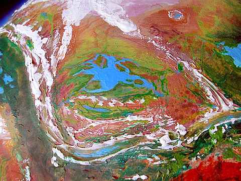
The U-shaped Raksar Sea is nearly 2000 km long (1200 mi). It lies between the towering Orovar Range, the low Muptips, Kantol Rift, and the polar tundra. Raksar's shores bear a wide evergreen forest, one of the greatest in the north. The warmer south shore even has a few pioneering villages of elaffes, settlers from the Ohhh Forest far to the west. Because they can reach many meters into their fruit trees unaided, these tall people didn't need to breed short trees; theirs can compete for light with wild ones. So these silviculturalists don't clear the forest to plant orchards--they just dot the primal wood with their own creations, enriching its food supply. But Raksar Forest won't be changing character fast: elaffes are slow-moving, slow-growing, slow-breeding people. With no natural enemies and a lifespan measured in centuries, they can afford to take their time.
The north coast is rugged; the splash apron of Ombra Crater forms a broad peninsula, the center of Raksar's U-shape. Ombra's rays of debris form straight, radial capes and "fjords" along the north shore, 160-250 km long (100-150 mi); stray mountains of debris also form the Brako Islands, which nearly divide the Sea here. The Brakos stretch hundreds of km, though you need a good map to tell which "capes" are really islands. Narrow Ombra Strait (only 10 km wide--6 mi) leads from central Raksar into Ulvas Arm, the western third of the Sea. To the south far wider Brako Strait (32 km/20 mi), also leads into Ulvas Arm. Most of the people here, as on the mainland, are mops, hunters and conifer-seed-eaters well adapted to boreal forest, though thotters fish the fjords and islands.
THE CRATERS
To the north rises one of Tharn's largest, ruggedest impact features: Ombra Crater, 190 km wide (120 mi). A cool lake fills the floor, 1 km below the plains outside and 3 km (10,000') below a ringwall snowcapped even in summer. It's a little world of its own, sheltered from the polar winds. The inner north rim, tilted toward the sun to the south, feels almost temperate; the northernmost flyotes on Tharn live here; in the dense air of the crater floor, they can fly, if not soar as easily as their cousins in deeper craters like Heloon or trenches like Mrr. They form a hybrid culture with thotters, mops and camaroos living round the lake.
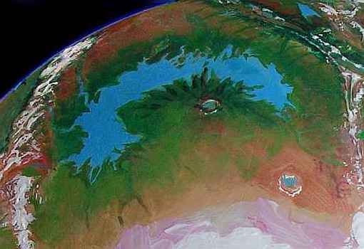
To the northeast, Ulvas Crater is an equally huge impact scar, but much shallower, with low walls, just 300-1000 m (1000-3300'), and a sediment-choked floor with a shallow lake. It's no mystery why Ulvas is so flat: ice-bearing strata probably melted to mud on impact, for Ulvas lies in the polar tundra, a thousand km (600 mi) northwest of Ombra Crater. Despite different depths, the two craters' sizes and ages are similar; they may well be simultaneous scars from a chain of comet strikes. They may have more siblings buried by the ice of the polar cap or whose ringwalls sagged away to nothing in wet tundra. Sandcastles!
Treeless and windy, Ulvas has few permanent residents. But every summer, all the mamooks for thousands of km gather at the north end in the lee of the crater wall, for a chong-ma: a music festival, a competition, and a marriage market all in one, where mamooks of both sexes try to impress potential mates with ballads and drum-stories.
The east end of Raksar Sea bends north into another great lobe, Koba Arm. The shores are low and marshy, but still backed by forests where mops live, except for the Koba Delta at the north end of the Arm: here the marsh fades into windy, treeless tundra, home only to mamooks.
THE OROVARS
The Orovar Range is a chain of huge shield volcanoes, like the Hawaiian chain without their cloaking sea...or the volcanoes of Mars, for the southern Orovars rise 12-16 km (40-50,000'). Mount Gholit, at the southwest end of the range, resembles Olympus. The hot spot creating the Orovar chain has already crept a bit further southwest: on Gholit's knees, a few young cones already rise as tall as Fuji, Ararat and even Denali.
All the main peaks, being above most of the atmosphere, are nearly bare rock; monstrous calderas yawn fifty miles wide in utter silence. Not a bird, not a grassblade. It really could be Mars. Even the Orovars' shoulders above 8-10 km are virtually dead. But down around their waists, 5-7 km up (say, 20,000'), mamooks browse lichens and grass, followed by camaroo in the alpine meadows 4-5 km up, then a ring of mops in the cool evergreen forests at 3-4 km, and so on down their foothills--half a dozen species in concentric contour-belts. These foothills and the rolling Shental Valley to the east are rather culturally innovative given the sparse population, because so many species with different habitat-needs live so close together.
Shental Valley's warm by Raksar standards, though it's just a dry cool finger of the huge, fertile Barsoom Basin south of Raksar. The streams flowing southeast out of the mountains collect into the Shental River and flow 1000 km southwest to Lake Thimret, then on through greener prairies to the Rippagong Sea. Above Thimret, the valley looks like Nevada: piny heights, scrub and dry grass on the valley floor, green veins of broadleaf trees along the rivers. Further south, storms off the Rippagong turn the scrubland into a fertile prairie.

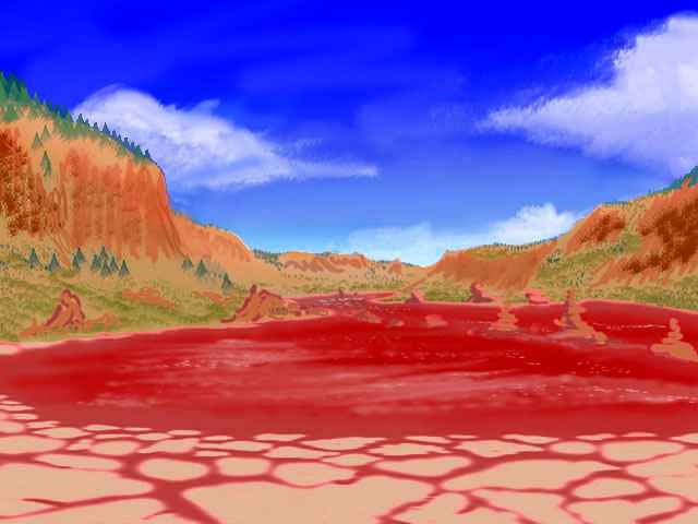
But the rains can't cross the Orovars. West of them lies the Tlani Desert, a triangular red plain twice the size of Texas. Tlani is broken by streams running down from the Orovars and the ridges of Kantol Rift; it has no lakes of any size. A few herds of small, childlike plains wingbok graze the desert flats, and a few villages of flyotes farm the river canyons, but it's a sparsely settled region compared to the green shores of Raksar to the north or Rippagong to the south--or the greater seas beyond, in Barsoom.
World Dream Bank homepage - Art gallery - New stuff - Introductory sampler, best dreams, best art - On dreamwork - Books
Indexes: Subject - Author - Date - Names - Places - Art media/styles
Titles: A - B - C - D - E - F - G - H - IJ - KL - M - NO - PQ - R - Sa-Sk - Sl-Sz - T - UV - WXYZ
Email: wdreamb@yahoo.com - Catalog of art, books, CDs - Behind the Curtain: FAQs, bio, site map - Kindred sites