
Rronk Woods
by Chris Wayan, 2005-6
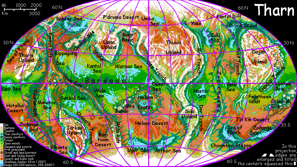
Map, Tharn's homepage, Peoples of Tharn, Regional tours, Geology and Evolution, gazetteer, terms explained. More worlds? Planetocopia!
INTRODUCTION
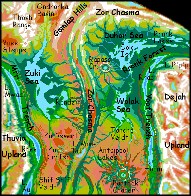
This tour explores the wooded northern basins settled by the elaffes, including lands all around northern Zor Chasma--mainly Rronk Forest around the Duhor and Wolak Seas, but also the huge forested Zuki Basin to the west. Nearby regions with their own pages: Mrr Trench to the west, Yoof Trench to the east, the Parthak and Zu Deserts to the south, and the Northlands.
I'll start in the west and work east.
THE WEST: ZUKI BASIN
The western border of the basin is abrupt--the great plain bows up into low north-south ridges, then cracks and terraces as it dives into Mrr Trench, 3 km deep (10,000'). Down in that trench is another world, around Lake Yoee, an oasis of warm dense air in a chilly region; at its north end grow the northernmost woods in the world. Yoee's quite salty, as the dry polar air evaporates it; the lake only exists because it's fed from the south by even larger Lake Mwaa.
Mrr, Yoee, and Mwaa are just approximations of lebbird names. These elegant winged omnivorous felines tend orchards all around the great sunken lakes, but they're trapped in this terrarium; in the thin air of the plains two miles above, they simply can't fly.
Though the air is cold and thin, the high plains are still rainy (for Tharn). The source is no mystery: Zuki Sea, a shallow brackish sea 1300 km long and only about 250 wide (820 by 150 mi). The sea's west coast is fairly straight, due to the hills. But on the east, Zuki Sea is a tangle of shallow sounds: long, treeless, windy Thosh Arm in the north, then Gomlap Bay, the Insoralta Peninsula and sinuous Insoralta Sound south of it, then the Psop Peninsula, like a dented bowl with narrow, marshy Lake Psop in its center, and at the south end, Manlat and Zu Arms. To the southeast, Lake Rondzin, 160 by 320 km (100 by 200 mi) extends this land-and-water labyrinth. Except for the Himalayan air and purple sky, it could almost be pre-industrial Puget Sound.
Some arms of the Zuki Sea are silty clambeds, but rocky sections are full of kelp forests, sheltering hordes of fish and large invertebrates. Thotters fish from the shores and islands. They don't venture far inland, though--dense, dark woods cover most of the Zuki Basin, taking advantage of the rain. Two other species share the deep woods: the silviculturalist elaffes and woodcarving mops.
To the east, upwind of the sea, the air is drier. The woods break up; trees huddle along streams descending from the ridges of Zor Chasma. Elaffes and occasional flyote packs farm the sheltered valleys, but between rivers there's just a great windy prairie, Rondzin Steppe, used only by camaroo herders. They're semi-nomadic, grazing flocks in summer but retreating to villages in the valleys and weaving through the winters, leaving the steppes bare to the polar winds.
Rondzin Steppe is lonely land--and likely to stay so. Tharn's full of peoples adapted to wildly different habitats, but the only other species really comfortable on cool grasslands, the lobbras, can't tolerate thin air--and the ridges to the east, 2.5 km high (8000'), have so far blocked the lobbras from spreading here.
Even the elaffes, who did immigrate from the east, have only been here a thousand years. They evolved in Yoof Trench, in air no thinner than the Alps, and while they've adapted to the Himalayan air of the plains, they can barely tolerate a further drop in air pressure. So it took them long generations (and many camaroo tales) before anyone risked their lives to cross the forbidding barrier of mountain and desert called...
ZOR CHASMA
Zor is a chasma, a rift valley analogous to Earth's mid-oceanic ridges. It stretches nearly pole to pole. The ridges flanking the rift aren't rugged, and are modest for Tharn, but they're still an ecological barrier. The ridges snag storms on their outer faces, so the central chasma is dry, ranging from savanna at the equator to a desert strip around latitude 30 and scrubland further north. Forest creatures like elaffes find it unlivable. It's no surprise, then, that elaffes took millennia to dare Zor's thin air and drought to reach the friendly woods to the west around the Zuki Sea.
Southern Zor is dotted with long, narrow riftlakes, like our Lake Tanganyika and Lake Malawi. But here in the north, there's only one of any size: Lake Manlat, 320 km long and 100 wide (200 by 60 mi), lying in a dry stretch of the rift. Manlat's a bubbling, briny mineral sump, lurid pink with halophilic bacteria; its shore is paved with hexagonal "flagstones" of mineralized mud. Out in the depths, scalding hotsprings build twisting tufa towers like drunken skyscrapers, encrusted with bizarre thermophilic life. But unlike Earth's "black smokers" these living smokestacks reach to the surface, and sometimes beyond; a weird little island chain runs down the lake's center--floating towers and terraced fountains. Too bad they all smell like rotten eggs.
Though Manlat's far too young to be the source, Tharnian life probably first crept onto the land from a riftlake much like this. Such towers and reefs provide an ideal transition for life, not just from water to land, but from chemical-feeding to photosynthesis. Because Tharn's rift zones are exposed, mineral lakes and sunlit vents aren't rare; photosynthesis evolved many times, as did air-breathing among animals.
The result is a far more diverse flora and fauna than Earth's. Compare a centah, six-limbed but very like an Earth mammal, to a lobbra, like a giant lobster crossed with a zebra; they share habitats and even general shapes, yet look as if they evolved on different worlds. In a way they did. Under the fur and chitin, their metabolic differences are equally huge. They ancestors evolved in different lakes, and solved the problems of breathing and land-locomotion independently. Their last common ancestor was a billion or more years ago. For more, see Geology and Evolution.
THE EAST: DUHOR AND WOLAK
Tancho Veldt is a bit warmer than Rondzin Steppe, and is populated with three veldt-specialized peoples: lobbras, centahs and veltaurs. Thotters and even a few elaffes live along the rivers, too.
The only real landmark on this great plain is Tancho Crater, 65 km across (40 mi). Its rain-catching rim supports the region's only forests. But the crater floor is savanna and marsh, with few trees, like a scaled-up, cooler Ngorongoro. The floor is only 1.5 km (5000') below the surrounding veldt, itself at about 1 km altitude; so the air on the crater floor is far too thin to lure any of the flying peoples of nearby Yoof Trench.
Further south the veldt fades into desert, the Parthak Desert, a plain broken only by the great oasis of Parthak Crater, so much bigger and deeper than Tancho that it's an ecological and cultural world of its own--see below.
North of Tancho Crater, the prairie greens as it gradually slopes down toward the Wolak Sea. Wolak is 670 km long (420 mi) and half as wide; the rugged, ragged shores look quite Mediterranean, with groves of oaklike trees dappling grassy hills. At least in summer. Winters see brief snows.
Thotters live on Wolak's innumerable capes and bays and islets; most of the forest is a great elaffe orchard. The two species form a single culture, despite their size-difference; besides a brisk trade in foodstuffs, elaffes need thotter dexterity for fine craftwork, and elaffe strength makes them dominate construction.
North of the Wolak sea, the forest is mixed: sheltered valleys are still elaffe orchards, but mop villages nestle under dark evergreens on the ridges and plains. This is the beginning of Rronk Forest, the largest boreal forest on Tharn. This cool evergreen strip runs 5000 km in a great arc from the Wolak Sea north to the Duhor Sea then east to the Sea of P'tang. It's an elaffe heartland, though shared by thotters, mops and some camaroos--all the snow-tolerant people. No surprise: the middle of the arc reaches 55° north.
The heart of the region, and its biggest source of rain, is the Duhor Sea, 1000 km long and 300 wide. The shores are mostly evergreen forest, but south-facing bays and sheltered valleys often have huge, haphazard orchards tended by elaffes.
Duhor is dotted with islands. The largest are the Gok Archipelago; the central pair are each 160-190 km long (100-120 mi). All the Goks are covered in dense evergreen forest dotted with mop lodges. On the south shore the dark woods brighten into elaffe orchards; capes and coves with gleanable reefs and "kelp" forests have thotter villages.
The Duhor Sea drains south to the Wolak Sea, which lies in a warmer, drier, higher-evaporation zone; so Wolak is salty and Duhor fresh. Since they can drink Duhor itself, thotters here can settle on any cape or rock out near the best fishing; they don't need a cove with a stream, as they do on the coasts of Wolak or Lake Hoom. While the Duhor thotters still trade and have plenty of contact with elaffes and mops, there isn't the same intimacy. "Convenience breeds apathy" isn't quite fair, but... inconvenience does seem to breed cooperation.
South and east of Rronk Wood lies long Yoof Trench, a biological hot zone meriting its own page. Elaffes evolved in its depths and still dominate the forested shores of Lake Rrao and Lake Hoom, though today an absolute majority of elaffes probably live up in Rronk Wood.
East of the Duhor Sea are the four Rronk Lakes, each 100-250 km long. Cool and misty, their maritime influence extends Rronk Wood another thousand miles.
THE FAR EAST: OHHH AND P'TANG
Rronk has no far eastern edge--a narrowing corridor of scruffy open woods along the icy Drampe River leads all the way to the Ohhh Forest on the Sea of P'tang--all in all, the wooded strip runs over 5000 km (3000 mi) from east to west, the largest in the northern hemisphere.
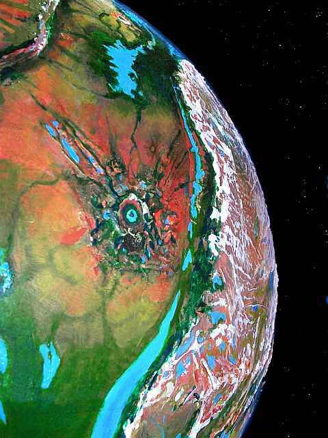
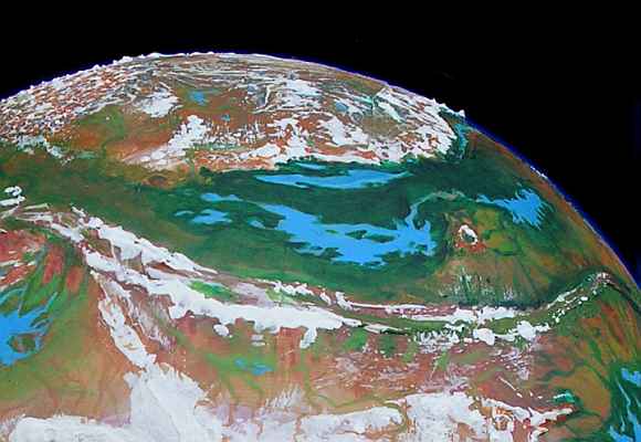
The orbital photo to the left was shot from over the North Pole, so east and west are reversed. the Duhor Sea's in the center, Rapass Crater and the Wolak Sea are center-right, the wooded Lower Drampe Valley's center-left, narrow Lake Rrao down in Yoof Trench is top-center, and Dejah Upland's on the horizon--the green and brown basin is the Upper Drampe.
Ohhh Forest is about 720 km (450 mi) long and stretches from the shore inland to the bizarre mountains of the Artolian Chaos 500 km inland (300 mi). In Ohhh, thousands of elaffe colonists tend new orchards (meaning only centuries old, not millennia--elaffes live up to 200 Earth years, and they take the long view).
But Ohhh isn't a one-species garden. It's warm enough for a large minority of mops, camaroos and even a few lobbras.
THE IMPACTS
This close to Zor Rift, all the crust is fresh--the oldest rocks in the region are in Mrr and Yoof Trenches, and date back a mere 100 million years. Based on location, Rapass and Parthak Craters are 30-50 million years old at most. They may be far less. A chain of smaller but similar craters to the west, stretching from 25 south to 30 north, suggests the impact of a comet train like Shoemaker-Levy on Jupiter. If the two giants were part of this group and were split away from the rest by the spreading crust, they're just 12 million years old.
Multiple impacts this big must have devastated Tharn. Yet my Terran readers may over-estimate that devastation. Earth's wetness and richness may make it unusually vulnerable to impact-related mass extinctions. Consider just three consequences of the Chicxulub Impact that killed off the dinosaurs: gigantic tsunamis, worldwide firestorms, and billions of tons of caustic calcium carbonate dust in the air--all that carbon upset the pH (acid/base balance) of the seas, and after the smoke cleared, global winter probably swung into a worldwide heat-spike as fast and severe as our human-caused heatwave. A double climatic whammy!
But poor Tharn lacks oceans, so tsunamis were local and limited. Firestorms were limited to forested regions, far smaller on Tharn; way less smoke and CO2 darkened the skies. And the Tharnian impacts hit fresh basaltic crust, not deep carbonate-rich sedimentary strata full of coral and shells; the effect was like a big volcanic eruption, with cooling and acid rain, but not long-term worldwide poisoning or double climate swings. Poverty has its perks. Tharn's relative sterility speeded its recovery!
PARTHAK CRATER
Parthak Crater is Tharn's second largest--only monstrous Heloon Basin surpasses it. Parthak is 300 km (190 mi) rim to rim, with a splash apron and rays spreading 1000 km in all directions. Parthak lies in a dry zone where weathering is fairly slow; while there's one pass in the southeast only 2.3 km high (7500'), parts of the ring reach 5000 m (16,500')--high enough not just to snag clouds but to create them even in dry desert air, generating their own (sparse) rain and snow. Open pine forests cling to the outer slopes, the summit ridge is alpine meadows and snowfields, with small glaciers in shady north-facing cirques.
The inner slope is a surreal sight: the curving mountain wall is 8 km high, as tall as Everest! That's so high that even on little Tharn, with its sharp curvature, the far side 300 km away is above the horizon--just barely, on a very clear day. And the great bowl below you is often dappled with clouds. The crater's air is both denser and more humid than that of the surrounding desert plateau. Lake Parthak fills much of the crater floor; the central peak is now an island. The lakeshore is 3 km below datum; the pool of denser air makes the basin hot for this latitude as well as more humid. This creates a densely wooded air-oasis sheltering winged species, including villages of lebbirds and flyotes. The ecological anomaly creates a cultural island, too. Trench and high desert species who rarely meet in the outside world here live side by side.
The other great crater is Rapass, 200 km (125 mi) across. Up between the Duhor and Wolak Seas, Rapass is so far north that the shady sides of both the south and north rim have extensive glaciers; a cold, milky lake 30 km (20 mi) wide fills the center. Dense, dark forest covers most of the floor and lower slopes. The floor is 1.5 km below datum, enough to give the basin a mild climate--nearly subtropical in fact--but the basin's not quite deep enough and the air's slightly too thin to attract more than a handful of lebbirds, though some flyotes live here. Mops, thotters and elaffes dominate the population--not so different from the woods outside. A pleasant air oasis, but not the cultural and ecological anomaly that Parthak is.
World Dream Bank homepage - Art gallery - New stuff - Introductory sampler, best dreams, best art - On dreamwork - Books
Indexes: Subject - Author - Date - Names - Places - Art media/styles
Titles: A - B - C - D - E - F - G - H - IJ - KL - M - NO - PQ - R - Sa-Sk - Sl-Sz - T - UV - WXYZ
Email: wdreamb@yahoo.com - Catalog of art, books, CDs - Behind the Curtain: FAQs, bio, site map - Kindred sites