South Pole
by Chris Wayan, 2005-6
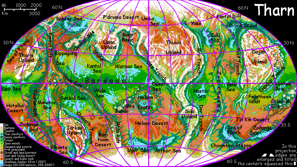
Map, Tharn's homepage, Peoples of Tharn, Regional tours, Geology and Evolution, gazetteer, terms explained. More worlds? Planetocopia!
INTRODUCTION
The South Polar region is huge but sparsely populated. This will be a short tour--I circumnavigated the north pole in some detail, following the famous paw-prints of Sholika, the Tharnian equivalent of Magellan. These southern tundras are so similar I don't want to repeat myself.
Well, there is one broad difference--it's why no southerner circumnavigated Tharn at high latitudes first. It's as short in kilometers, but not as easy in the south. Several glaciated mountain ranges, high as the Andes, rise in the path of any southern Sholikas. Over the centuries, many may well have been tempted to try circling Tharn here. And died trying.
Besides, as I write, it's a cold day--my hands are pale and numb. So I'll keep this short and emphasize islands of warmth and life.
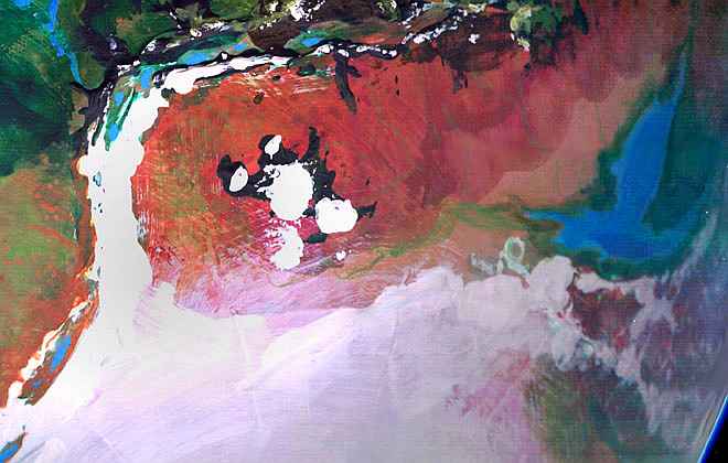
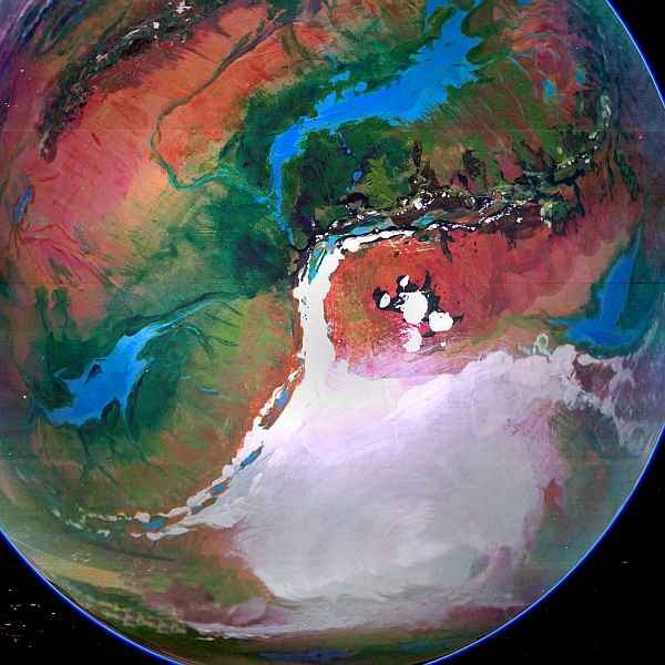
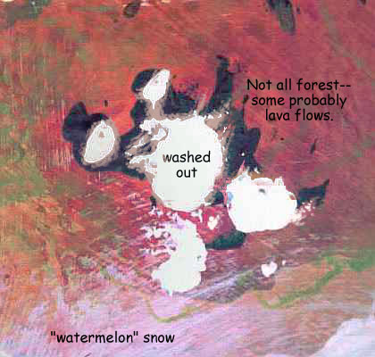
They do exist--the apparent circumpolar desert does have oases. For example, quite a wide belt of cool-temperate forest stretches from the Sea of Thark to the Zodanga Sea, some 5600 km (3500 mi)--a fourth of the way around the world! A second such belt links the Anthor and Ugor Seas on the far side of the pole (bottom of the orbital photo); a third cool forest surrounds the Ghasta Sea (inverted T shape on the right).
These three woods support several million camaroos, mops, and semi-aquatic thotters.
Even better, two trenches thrust into the Antarctic zone. The depths of Chanath and Dor Trenches hold pools of dense, milder air, effectively like that of the plains a thousand miles north. Here temperate forests flourish, even orchards, tended by temperate-zone fliers who can't survive up on the cold thin-aired plains--elegant lebbirds and the unique, seasonally breeding Chanath subspecies of trench wingbok.
But most of the great plains ringing the Antarctic ice cap are tundra--well, really just cold steppes and deserts thawing only a month or two each year. They may look rather Martian, but in one way they're easier on plant life than even Earth's subpolar tundras. For tundra means permafrost, a frozen layer going down as much as hundreds of meters that you find, at least as I write this, in Earth's polar regions as well as all over Mars. Mars's may thaw in the next few centuries, as humans settle and restore its ancient climate. Earth's permafrost is already melting. But even without global warming, without us, Earth's permafrost would slowly thaw, for it's a relic of our last Ice Age. And Tharn lacks ice ages. Dry Ages, yes--but Tharn's immune to our particular planetary disease. Even near the polar cap's edge, it's coldest at the surface; when Tharn's soil does thaw, even briefly, plants can send roots down as far as they like. No icy mortuary slab down there!
JOOM
There's one distinctive feature not present in the north. The Joom Range is a great cluster of five major and many smaller volcanoes, all heavily glaciated, rising from the cold steppes south of Thurian Rift and west of the Ghasta Sea. Central Mt Joom is the tallest, at about 12 km (40,000'); a dozen more top 20,000', higher than Denali or Kilimanjaro. These are massive volcanoes, though steeper in slope than true shield volcanoes like Hawaii, Olympus or Tharn's own Chinchak Range. The southern slopes and heights above 2 km are quite barren and largely ice-mantled; but the long north slopes face the sun and block the harsh polar winds; such subpolar microclimates are so mild they might as well be a thousand km further from the pole, and support lichen, grass and even sparse evergreens in some valleys.
I suspect pastoral camaroos and even small mop communities could probably survive here (if not flourish), but Joom's ecological islands are cut off not just by thousand-kilometer steppes, cold and windy, but by great icefields all around. Well, except for the east, where a dedicated caravan could, in summer, make it in from the Ghasta Sea region. But so far, nomadic mamooks are the only residents; no one else has done more than visit, take a good look, and turn around for home. I can't blame them. Settling might be climatic hubris; like the Vikings in Greenland, a community would always be on the margin; even a minor cooling could slowly strangle your economy and gnaw away your health. I might risk it--but I wouldn't dump such a risk on my pups, or grandpups.
Tharn has other clusters of tall volcanoes like the Jooms, usually where a rift zone curves or forks. As the crust spreads from the rift(s), it's squeezed in two or more directions at once, and one way the pressure's relieved is in massive volcanoes. Earth does it too: that's how we got Kilimanjaro and its many sister peaks!
If the Jooms had arisen at a warmer latitude, they'd likely have been major cultural centers, offering habitat to a wide range of species up those long slopes. That's exactly what did happen to the equatorial volcanoes called the Big Four in Tars Triangle: tectonically quite Joomian, but far warmer, these peaks each support concentric rings of villages of many species, together forming an eclectic society.
The Jooms do come alive briefly, each summer: the largest chong-ma (a mamook song-festival) in the south is held in these sheltered valleys, starting on Midsummer Day. It's a loud, raucous event, part fair, part singles bar: both sexes (indistinguishable to non-mamooks) sing "songduels" to gain status and impress potential mates. The sheer size of the participants (and their booming voices) may cause Terrans to feel as if they're lost among dinosaurs; but under the roaring is a lot of sophistication. Mamook songs are usually narrative, always from dreams (or at least pretend to be) and are judged as much on their humor and psychological insight as on beauty of music and voice.
But most of the year, the Jooms are just a lonely little slice of Old Mars, before terraforming.
ON NORTH-BIAS, CASH and BAD PHOTOS
So really--why is this tour so skimpy compared to the north? Sholika's just an excuse. The real reasons say something about the art of mapping. Earth cartography has historically favored the Northern Hemisphere and the poles--not only do Mercator maps exaggerate polar regions, many non-Mercator world maps, even today, don't center the equator! The far south gets clipped, the north, exaggerated. This is often interpreted as pure cultural bias, since modern cartography developed in Europe, a northerly zone; but an argument can be made that it's either land-bias (there's indisputably more land in the north) or an ecological, biomass bias; Antarctica's ice creates foul weather making the far south colder, less fertile, populated and accessible than the north; the climatic equator in many places really is several degrees north, and placing this in the middle makes ecological sense.
But not on Tharn. If anything, the biomass is a bit richer in the south; so much of the Northern Hemisphere is uplands. Yet I did a whole page in which you tour the Northlands, circling the pole--in far more detail than this page. So how did an Earth bias get transferred here? The immediate reason's simple: my orbital shots of the far south are terrible! I could invent a pseudo-explanation (a lone fly-by over the north pole but none over the south?), but the causes of my photo shortage are more interesting.
These ain't computer models! I make all my biospheres from second-hand globes found in thrift stores. Only two exceptions: Lyr and its moon Oisin. A globe big enough for Lyr would cost hundreds, so I built it from scratch, and Oisin's so small I used a plastic Christmas ornament. But for Tharn I used a globe--I hacked (ow! Those trenches! Cut my thumbs up gouging those out) and built up (acrylic goo for mountains, crumpled tissue dipped in acrylic goo for uplands) and painted.
Why thrift-shop globes? They have advantages: they're cheap, which matters to an artist with zero funding (hint hint); the stand is mighty convenient, and the pole-to-pole support-arm usually shows latitudes north and south.
But, for reasons that must be obvious, the poles of old globes are awkward to sculpt and paint--especially the south pole. Normally I remove the stand to do those bits. But Tharn's globe fought back! Just couldn't get the bolts out. I worked around the north pole, but in the south, the stand was in the way. In desperation, I was forced to reach in with long-handled brushes at a low angle (just like polar sunlight!) I roughed in a big sloppy polar cap... and declared it winter. A makeshift solution, but tolerable.
Now, I could blame all this on northern bias--mapmaker's habit of putting north at the top. Or we can blame the World Book Encyclopedia company, which made this particular globe. How dare they do such a solid job! All the other companies make shoddy stands, easy to tear apart! What's with these people? Do they want the planet to last, or something?
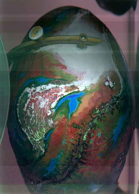
Now imagine trying to get orbital scans and photos with a great big unremovable STAND in the way! I wasn't even going to HAVE a "south pole" page until this morning, when I finally found a big socket wrench that unfroze one bolt, freeing part of the stand, and letting me get one poor off-center scan of the south pole. Tried others, but they were garbage. This hazy shot's the best I could get, and it was badly distorted and washed-out; it took a whole morning of digital tweaking just to make it viewable.
I don't generally like to break the illusion, but I'll make an exception, here, to make the point. Here's a raw scan I saved! Yes, a scan, not a photo. I don't own a digital camera; many of the orbital photos in this series were taken with a borrowed one. Most of the close-ups are just scans. The distortion's not added. A sphere on a flat scanner comes out like this; most scanning lasers shine at a low angle and correct for this, assuming the scanned object touches the glass above; if it isn't, the echo is misplaced. Has to be corrected before any other processing--and you can see it takes a lot.
NASA scientists face analogous problems all the time, of course--mapping worlds by pasting thin strips of data together, while trying to compensate for glare and haze and equipment not built for the conditions it encounters (much like my flat-earth scanner refusing to believe the world is round). Our map of Titan still fades into haze except where a flyby's flown right overhead, and probing Europa beneath the ice still looks like it's a decade or two away, life or no life. Not all the hazards are space-based: the Feds actually tried to turn off a working Venus orbiter to save a few million--after spending a fortune to get it there! "Hey, it's just Venus--not Mars." Who cares about the girly planet? Let's get on with the thrust (ahem) to red-blooded, war-god Mars.
Anyone interested in planetology or space exploration knows the story: billions for guys in tin cans, but pennies for the real space heroes: unromantic little robots that go "where no (ahem) man has gone before" (and still hasn't).
But it's curious to how my own little project's distorted by NASA-like pressures! "Low budgets cause reliance on off-the-shelf components and enforces conformity to cultural biases... unless you fight." Is this a general principle in both science and wacko web art?
OK, OK, in my case, ineptitude with tools was a big factor here, too... and I can't blame myopic accountants undercutting a heroic posse of dedicated techies.
Unless, of course, my wallet attacked my fingers when I wasn't looking.
World Dream Bank homepage - Art gallery - New stuff - Introductory sampler, best dreams, best art - On dreamwork - Books
Indexes: Subject - Author - Date - Names - Places - Art media/styles
Titles: A - B - C - D - E - F - G - H - IJ - KL - M - NO - PQ - R - Sa-Sk - Sl-Sz - T - UV - WXYZ
Email: wdreamb@yahoo.com - Catalog of art, books, CDs - Behind the Curtain: FAQs, bio, site map - Kindred sites