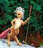
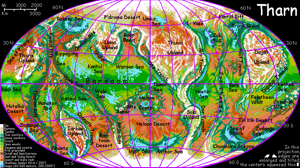
THARN
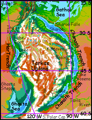
Tarkas Upland
by Chris Wayan, 2005-6
Map, Tharn's homepage, Peoples of Tharn, Regional tours, Geology and Evolution, gazetteer, terms explained. More worlds? Planetocopia!
INTRODUCTION
If Tarkas Upland were on Earth, it'd be a continent the size of Australia, and nearly as dry. But far more mountainous--Australia is old, but Tarkas is young and active, squeezed between two rift zones where new basaltic crust is spreading, shoving under Tarkas on two sides, digging deep trenches and pushing the upland still higher. The upland itself is harsh: the south is a near-Martian desert; the north, cold but habitable alpine meadows. Beyond Tarkas's northern tip, where three rifts meet, is a strange area meriting its own page: Tars Triangle. Most of the region's life (and interest) lies in the deep subduction trenches yawning on both sides of Tarkas: Har and Chanath Trenches.
We'll start our tour on the northwest rim. Picture yourself standing at the edge of a hanging meadow amid jagged peaks under a dark violet, star-spangled sky, looking down into a hazy abyss: Har Trench, fourteen times as deep as our Dead Sea Rift.
Har Trench is small, only 2000 km (1300 mi) long, but very deep--up to 5.5 km (18,000'). The prevailing winds are off Tarkas Upland, which squeezes all the moisture from them; the plains around Har are desert. But Har demonstrates the climatic strangeness of a Tharnian trench; it's so deep, with walls so high, it's nearly a closed terrarium. The dense trench air traps so much heat that the floor is tropical--and then some! And not just heat. All the rivers flowing off the rim of west Tarkas collect here into brackish Lake Rrit and smaller, freshwater Lake Jeet. They humidify the hot air, and as it rises, great thunderheads form... and the rain drenches the trench floor and walls. So, at 40 degrees south, surrounded by desert, at the foot of icy peaks worthy of Tibet, Har is a tropical forest!
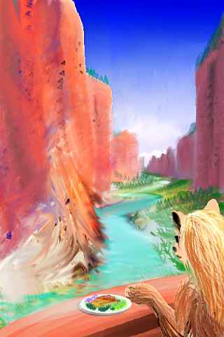
Many of Har's species are endemic, but only one of them is intelligent: the arthom (singular: artho.) The range of arthom is the most limited of all Tharn's peoples--nearly all of them live here around Lake Rrit and Lake Jeet, where they evolved.
Why haven't they spread, explored? They're not uncurious or lazy or clannish; it's in the blood. Literally! Arthom lack a good adjustment mechanism for their oxygen transport system. Most Terran vertebrates adjust to thin air by producing extra hemoglobin within a few days--but arthom stay sick for weeks and never fully adjust.
So evolving in a friendly, Earthlike oasis had a subtle, terrible cost: isolation. While arthom can breathe with effort up on the bed-plains, the air's too thin to fly in; they feel crippled and horribly vulnerable. And the uplands might as well be deep space! Here, arthom simply collapse; crossing high passes mean risking brain damage. They're as fragile as, well... humans.
The caravan routes north out of Har, quite by chance, are all so hazardous that no artho's ever crossed the equator, though a few trade representatives and diplomatic families now live in nearby Chanath Trench. They had to charter a grueling 5000-km caravan north up the Ing River, then around Tarkas Upland's northern tip, warily threading a low-altitude path between the volcanoes and dorsae of Tars Triangle. Like riding the Silk Road across Asia, sick the whole way--ugh!
The flooded trench of Ghasta to the south is a shorter, easier journey--the caravan route stays below bedlevel; uncomfortable but never dangerous for the arthom. So they've explored the Ghasta Sea region. But Ghasta's shore is barely below datum; the air's too thin for flight. So the arthom have left Ghasta to the mops, a flightless people comfortable in those cool, thin-aired woods.
Arthom don't travel for a second reason: the floor of Har Trench is unbroken forest, and arthom only feel happy up a tree. Travel doesn't just mean being sick and crippled, but feeling trapped and exposed on the ground--so the wide, treeless deserts around Har upset and disorient arthom the way walking a high wire would daunt most humans. Physically possible, but... phobically?
Given their fears, the arthom diplomats who made it to Chanath Trench are a study in courage.
Northern Tarkas is camaroo country, with rich alpine meadows below its snowy peaks. Still, many high basins have internal drainage and brackish lakes. And as you head south into the high heart of Tarkas it looks steadily more like Tibet.
To the east is the long teardrop shape of Kaltaven Basin, 1200 km long and 400 wide. Kaltaven's an arc-basin with an unusually high floor; thus it isn't desert like most arc basins, but a cooler, rather Mongolian steppe, getting enough winter snow to nourish short grass in spring.
In Kaltaven, camaroos and centahs herd losha (a sort of milkable ostrich-roo), and in summer nomadic veltaurs browse the meadows directly. On the east side the Kaltaven Range rise 5 km (16,000') to a height of 7 km (23,000') above datum; their east face drops over 12 km (40,000') into the Chanath Trench. That huge rise harvests rain--it's another world entirely.
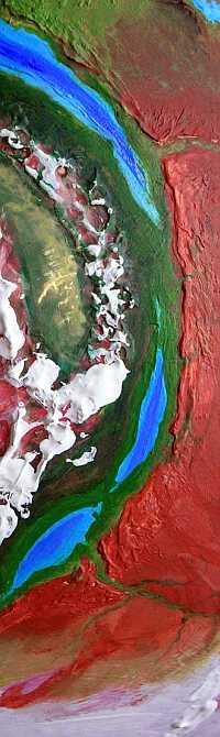
Central and southern Tarkas is a true high-altitude desert, both colder and drier than the north or Kaltaven's arc basin. In Central Tarkas, steep straight ranges east and west block all rain from kinder lands. These stark red dry valleys stained only by gray lichen and pink dusty ice could easily be mistaken for the harsh southern highlands of Mars.

At least until a tribe of ten-ton mamooks lumbers over the horizon... and suddenly the Great Tarkas Desolation seems rather crowded.
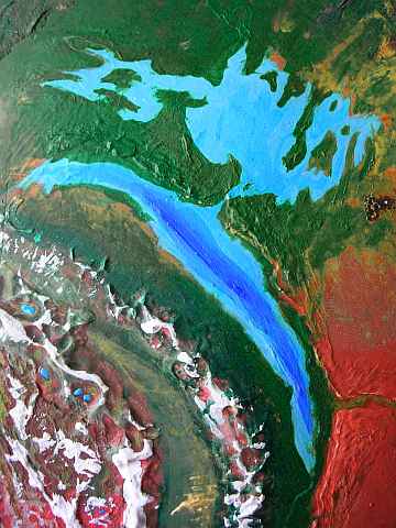
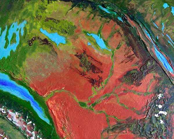
The region southwest of Tarkas may not look very wet, but it contains more water than any other area on Tharn. Where's it hiding? In the Ghasta Sea, on the lower left, the one that looks like a bird.
 At this latitude, the plains are cool steppes like Canada's prairies, with much more rain than around Har Trench to the north. And the steppe sags here; a wide, shallow bedlake collected, humidifying the winds even more. Thin evergreen forests rim the lake, home to a woodcrafty people called mops. Well-insulated with shaggy feathers, they're the only Tharnians who really like temperate forests. Typical food sources: annual, salmonlike fish-runs, berries (mops fell trees not just for lumber but to create berry-bush clearings), the growing tips of Tharnian evergreens (pleasantly spicy, but don't overindulge if you're not a mop; like Terran evergreens, they're rich in sugars and vitamins, but also resins (antifreeze?) which only mops are adapted to digest in quantity); and the nuts of half a dozen tree-species bred to be high-yield, that mops fertilize with fish-waste--which, along with wood chips, feeds mushroom-gardens.
Mops are highly visual: their villages are carved and painted into a mass of public sculpture, with no surface left untouched. No wingbok minimalism here! They carve totem poles, too, though these "totems" aren't inherited but dreamed. Many individuals have protectors--not quite gods or guardian angels, for the relationship is more equal. They most closely resemble the "spirit spouses" of Siberian shamans: friends marrying into the family, who just happen to be spirits! As you might imagine, mop kinship groups can perplex outsiders, since half one's relatives may be invisible...
Perhaps they were protecting all of Tharn, for Ghasta Sea is a barely-averted ecological catastrophe. Much of the rain generated by this bedsea falls just to the east, on the rim of Tarkas. Unlike Har Trench, a dozen short but muscular rivers pour into the Ghasta Trench below, filling it to the brim. The trench- and bed-lakes eventually merged into a large sea. This flooded trench is so deep, it holds fully 10% of Tharn's liquid water! And it could have been worse--it's shallow as trenches go (deep point: 2.4 km; average, only 800 m). If Har Trench, over twice as deep, had been at this latitude, a worldwide drought might have ensued.
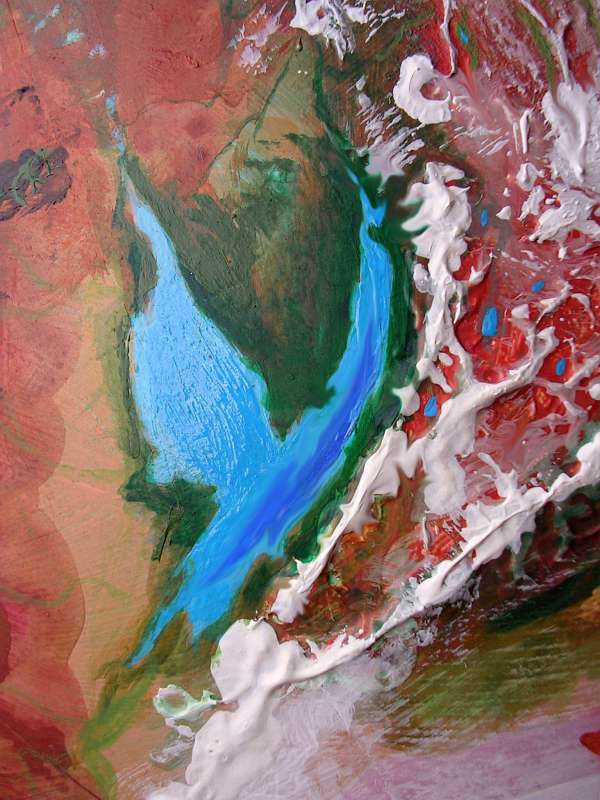
Such seas are called birdseas, since they generally look birdlike, with a slender trench-lake body and wide but shallow plains-lake wings. Just a few such seas forming at once can sequester much of Tharn's water, and this has happened repeatedly. Unlike glaciation, this odd mechanism is a matter of location and drainage; it's not cyclic. The amount of water in active circulation on Tharn changes irregularly over the eons, due to such bird-seas. Earth's present geography causes cyclic Ice Ages. But Tharn suffers irregular Dry Ages. Civilization has just enough time to forget the previous cycle when forests shrink, rains fail, and lake-levels all drop again. That's one reason technology here is simple: what gets saved from cycle to cycle must be portable and work without infrastructure, because cities are likely to be drowned--or have their water abruptly fail.
Is a birdsea a black hole, inexorably growing, destined to swallow all the water on Tharn? Not quite--just like gravitational singularities, bird-seas eventually self-destruct. The shallow "wings" silt up and shrink to a marsh, then a floodplain. The trenchlake still hogs nearly as much water, but with its wings clipped, our birdsea's surface area is far less, and far less water evaporates. Paradoxically, this lack of water-loss is fatal! Seas on Tharn largely recharge themselves--there's no big distant ocean sending rain. As the birdsea basin dries, air sweeping over the trenchlake harvests more moisture; much of it still rains back onto the nearby mountains, but the fraction that escapes the basin slowly drains the trenchlake back down until it's so deeply sunken its dense moist air stays down in the trench, creating a sort of terrarium with walls several km high--that is, back to normal for Tharn!
You can spot several former birdseas on the main map--just look for trenchlakes with extensive river systems in the rainier belts (around the equator and at 40-60 degrees north/south). These same zones hold possible future birdseas--for these, look for a bedlake and trenchlake close together with no hills to keep their watersheds separate...
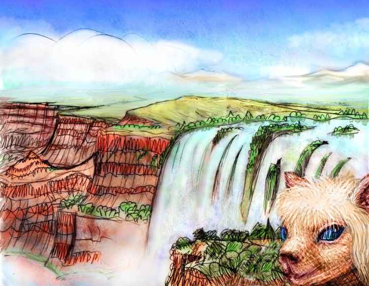
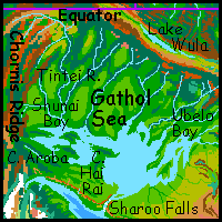
GATHOL SEA and SHAROO FALLS
The Gathol Sea, northwest of Tarkas, is a variation on the birdsea theme. This bedlake has been captured by Chanath Trench, spilling over in a spectacular cascade, Sharoo Falls. This wide Niagara-type fall drops well over a kilometer in one leap; lesser falls below, 50 to 200 meters each, drop from pool to pool down to Lake Sharoo in the trench. The river is quite large, yet Lake Sharoo refuses to fill, for it's in a dry zone further from the equator, and rains from the seas of Barsoom Basin are largely blocked by the parallel ridges of the Wula Rift Zone to the northeast. So Lake Sharoo, fed by the falls, is larger and deeper than most trenchlakes, but in this drier air, evaporation checks its growth.
The hilly lip around the falls may finally erode enough to drain the entire plainlake into the trench in a catastophic flood, but even then, the trenchlake will slowly dry again to its natural size, and the Gathol Sea will become a wooded or patchy basin, drained by a river winding down through a flood-cut canyon whose lower stretches will have huge cliffs, lenticular mesas... shades of Mars!
And this whole cycle has happened many times; the world map shows many trenchlakes with river systems that once were shallow seas.
On the other hand, many of these floods never created birdseas--only a few latitudes have rainy enough plains near a drier trench. Most birds don't hatch--and lucky for Tharn they don't.
As long as we're here, it's worth noting that Gathol's north and west shores are the richest lands in the Tarkas region outside the trenches--and the most diverse.
Gathol's coastal bluffs and rocky points are riddled with holes like huge swallow-nests: the cliff-dwellings of flyotes, who fish the lake and tend fields along the shores. Thotter villages dot the capes and islets, they aquafarm shallow bays, marshes and deltas. Since Gathol has an outlet, it's freshwater--drinkable--so thotters and flyotes needn't cluster only around rivermouths.
Dense populations of semi-arboreal bos live in the tropical forests of Cape Aroba and Shunai Bay; and herds of graceful veltaurs abound in the opener woods and meadows up the Tintei River, on Cape Hai Rai, and Ubelo Bay in the east.
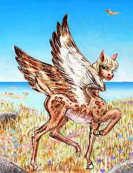
The southeast shore is drier, a mostly treeless savanna, for the winds often blow from the Bantoom Desert to the south. Herds of dwarf plains wingbok graze this veldt. Northerners call them pea-brained hicks--flat dull people on a flat dull plain.
And there's some truth to it. Wingbok this small have brains smaller than apes do. True, wingbok brains, like most fliers' brains, are far more efficient ounce for ounce than the brains of nonfliers.
But it is ounces/grams, not pounds/kg; South Gatholians are literally intellectual lightweights--cute, with their biiig blue puppy eyes and clumsy paws, but stupid.
So the Northerners are right; I'm afraid this plain is a sort of Tharnian Texas. Though it's not quite as bad as our version in one respect: here, at least, the idiots don't have guns.
I was about to apologize for that crack, but you see, I'm one of those "stupid California hippie faggot tofu-eaters"... and on and on. And sick of hearing it! If we Californians bad-mouth Texas right into the next geological era, we'll still be playing catch-up.
And I am playing nice--I didn't name that good ol' brainless plain the Enron Shore, now did I?
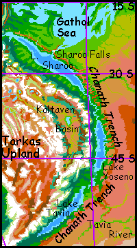
CHANATH TRENCH
Chanath is rich. It's shallower than Har Trench to the west, but it's far longer, and holds fully half the biomass and population of all Tarkas. It stretches from the subtropics to the subarctic--though the trench makes its own climate. And rain! The Kaltaven Range is so tall it catches every cloud straying from the Gathol Sea or the humid Barsoom Basin beyond. So Chanath's floor is mostly forest--where it isn't flooded.
The longest trenchlake in the world fills the north end: Lake Sharoo, 1900 km long and up to 250 wide (1200 by 150 mi). But Sharoo isn't a sea; it's freshwater. The lake drains south, via the Sharoo River, which winds several hundred km through a forested bottomland to Lake Yoseno, even deeper in the trench, and thus (though it's further from the equator) just as warm. Tharnian paradise! Even Terrans (those fussy, fragile creatures) could survive here. Lower ultraviolet and radiation levels, balmy climate, plenty of water, merely alpine air...
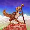
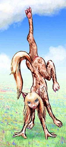
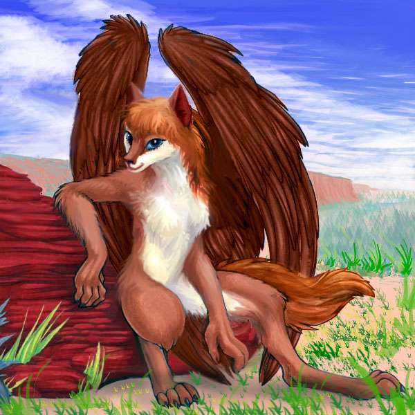
These mild lakeshores are a haven for wingbok, who can grow unusually large here and still fly easily in the dense air (for Tharn I mean). These oversize wingbok consider themselves another species, trench wingbok, though in fact they can still crossbreed with their simpleminded cousins. Still, it's an emotionally charged issue, and the wise visitor will avoid it. You don't want to get kicked. Those little hooves are sharp.
But their minds are too. That's what fuels the denial--the lurking fear that the gift of intelligence will be revoked as mysteriously as it was bestowed. Chanathian intellectuals know it's been proven their size and intelligence were environmentally determined, and not about to revert, but logic doesn't entirely calm that anxiety. Yet can my human readers really mock these antelope for their insecurity and denial? Is evolution taught in your local school?
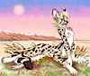
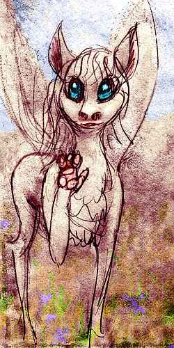
Trench wingbok are shy, sensitive people, with minimal material culture, but rich inner lives. Wingbok psychology will sound strange to readers of ape descent--unless you're painfully shy--or been to war. Wingbok are constantly on alert, wary of novelty, acutely sensitive to the subtlest threats. And yet, they don't find this troublesome, for their etiquette takes it for granted and defuses it with reassurances. And they socialize constantly--though sparingly, and always with room to bolt.
Alert and high-strung wingbok are never bored, for the smallest stimulus is enough. Just as every glance is a potential threat, every bird-cry is a poem, every rock a sculpture. A touch inflames, and lovemaking overwhelms. Though they seem an austere and materially impoverished culture, they're sensorially and emotionally rich. Unable to bear large herds, let alone cities, they're a whole race of graminivorous Emily Dickinsons.
But they do have a material culture. This may surprise you, given wingboks' lack of hands. Yes, they're best known for love poetry, depth psychology, and aerial courtship dances, but those prehensile tongues (especially working together) can do more than you'd think. Mates and family groups cooperatively tongue-weave brushy roofs for lean-to shelters, though many are cave-dwellers (in low gravity, caves collapse less readily, and thus are common on Tharn). Sharp hooves dig irrigation ditches and plant fruit-tree seeds. Murals and incised bas-relief rock-carvings are common on overhanging walls. They kick stones into intricate rock-mazes and figurative patterns. Indeed, lines of stones in wingbok trenches are never natural--they lead to water, shelter, or art.
Here's a typical wingbok village south of Lake Sharoo. You can see they make a virtue of necessity; it's a minimalist, nature-loving esthetic. The best house is barely noticeable; the loveliest garden, natural (discreetly enhanced, of course--but evidence of hard work jars a wingbok, rather like a face caked in too much make-up).
As I mentioned, a few arthom also live among the wingbok of Sharoo--descendants of trade representatives from Har Trench to the west. Today many of them tend orchards; their light weight and two clever hands make them better suited to fruit-picking than wingbok.
The easiest way to explore the length of the trench is to rent wings at Sharoo Falls and see Chanath the native way--from the air. It takes practice, but even a human (in good shape) can fly in Tharn's low gravity. And Chanath has plenty of thermals to ride.
So here you are, riding the updrafts along the sun-heated cliffs south of the falls. For a couple of days south, it's uneventful--red cliffs above, green wood below, blue lake to the west, and across it, hazy in the distance, the white teeth of the Kaltavens, forty thousand feet tall. The sky's a pale purple: red dust from the Bantoom Desert tints the thin air. It's not the salmon-red of Mars, but an absurd cartoon lavender, as if a very big six-year-old colored in the planet. "See what I made?"
On the third day, a great gulf opens in the red wall: Ghek Canyon. It's far deeper than our Grand Canyon, with great stone mesas like castles 2-3 km high. Here in the lower stretches, the riverbottom's flat, a few miles wide, and covered with fields. Holes dot the cliffs--flyote dwellings. You won't be able to fly too far upstream, so let's head on south for now--unless you have your heart set on exploring the Bantoom Desert.
Just a few hours past the rivermouth, Lake Sharoo ends at last. Rock-walled and forest-floored, the trench goes on--in fact, it starts deepening. You follow the Sharoo River draining the lake, on through the woods for another full day. The next morning Lake Yoseno gleams ahead: 670 km long and 120 wide (420 by 75 mi), it lies fully 4.5 km (14,800') below the surrounding plains, and has nearly double their air pressure--merely alpine, not Himalayan. You can pack away your breathing mask, if you haven't already. The population resembles Lake Sharoo's: a thriving wingbok civilization, plus a few arthom.
The flanks of the Kaltaven Range on the western shore, where storms off the lake drop their rain, are tree heaven--like the Olympic rainforest or the Redwood Coast. But the biggest groves here are taller than any on Earth, for gravity's much lower; trees don't work as hard to raise water to their crowns. While redwoods can reach 115 m (380'), some giants in sheltered valleys here approach 140 m (460').
From the south end of Yoseno it's only a couple of hours' flight to Lake Tavia, last of Chanath's lakes: a deep, cold leaf-shaped lake 640 km long (400 mi). It's nearly unique on Tharn in that its dense air sustains THREE winged peoples: a different (and unique) subspecies of trench wingbok, a small colony of arthom, and the largest, smartest flyotes on Tharn. The Tavian wingbok, alone among all their extremely varied kin, breed seasonally; winters here are dark and fairly cold, though nothing like the chilly plains 4 km above. The Tavians mate and pairbond year-round, but are nearly infertile except during the fall; most fawns are born in late summer when early crops have been harvested. The fall "mating festivals" shock other wingboks, who prefer to think of Tavians as another species entirely. Still, Tavians who venture to lower latitudes are cross-fertile with other wingbok... and their mating pattern shifts to noncyclic! Wingbok are just a protean species. It's unclear if the the trigger for fertility and sterility is temperature or changing light, but it may lie latent in the genes of all wingbok, unexpressed except at high latitudes. And Tavia is one of the few near-polar places warm enough for wingbok.
All this has suggested (to Tavians, at least) that conventional wisdom about wingbok is backward--they didn't evolve on the plains and then discover the trenches, they evolved here, in Tavia, and spread north, eventually colonizing the plains--at a terrible cost. This devolutionary view appeals to Tavian wingbok despite its pessimism, since it normalizes their sexual customs; the northern wingbok, who find Tavian sex festivals so shocking, have just lost their ancient rhythm.
Factual? Who knows? Pride, not logic, shapes popular views of evolution--or should I say shame? My human readers have no cause to look down on wingbok. 150 years and Darwin's still controversial. Apes? We're not APES! Shame trumps logic.
Most trenches on Tharn lack large numbers of flyotes; they're creatures of the plains and canyons. Not because they don't do well in dense air--quite the opposite!--but the other winged peoples of Tharn (arthom, lebbirds and wingbok) occupy most of the fertile trenches already, and flyotes can't compete. It's not quite like apes in a human world--flyotes, though their brains are smaller and their technology backward compared to the other flying species, are far smarter than apes; but they do have to fit into or around existing civilizations. But Lake Tavia's unique: there are no lebbirds here for it's far beyond their range; it's the very edge of the wingbok world--despite the racial-origin myths of the locals, there's no real archeological evidence for Tavian wingbok beyond 5000 years ago; and the arthom came even later, in tiny numbers. Flyotes settled here so long ago they were alone, and had a chance to build a culture on their own terms
They did startlingly well. Unlike wingbok, flyote size and growth is genetic and dietary, not regulated directly by air pressure, so they didn't double in weight in a single generation; but the fertile bottomland made for a better diet, and the high air pressure did remove the practical ceiling on flight-weight. Skeletal evidence suggests it only took a few dozen generations to grow a new breed of big, handsome, brainy creatures almost unrecognizable as flyotes--as different as a wolf is from a coyote, or a gorilla from a human. Even Tharnian specists (and they do exist, especially regarding flyotes and plains wingbok) who habitually dismiss flyotes as mere intelligent animals or "people in a million years" have to concede that Tavian flyotes are people--no ifs, ands, or buts. They're:
No cafes up on these plains. They're a cultural backwater--if you can find water at all. Well, one exception: the centahs and thotters around the Gathol Sea do extend east up the Moak River to Lake Moak, 500 km long (300 mi). Cafes, or at least inns.
But the plains and basins to the south and east are mostly dry, and sustain only a thin population of centah herders, plus a few veltaurs along streams. Increasingly, the land is left to flyotes and wingbok--both limited in size (and thus brain capacity) by the flight-weight limit set by the plains' thin air, and considered, by many Tharnians, to be not merely primitive but "half-people".
It's hard for Terran readers (shaped in reaction to a racist and colonialist era) to view Tharnian species objectively. Part of our problem is that most human languages have two sharply defined categories, "animals" and "people"; and we have equally on-off criteria for sorting: tool use and language. Now that better research shows many species to be tool users, and there's evidence that cetaceans, wolves, elephants, parrots and ravens have languages of some kind... our simple binary categories are under strain.
In contrast, Tharnians of all species routinely assign "peopleness" in gradations according to the sophistication of communication and manipulation of the environment. Flyotes and wingbok are prime examples. These "people" east of Moak have simple languages, use tools, and those along the river even practice simple agriculture; most Terrans would thus call them people. But Tharnians faced with the sharp contrast between the plains-folk's childlike intellects and their big, bright, sophisticated cousins in the trenches hesitate, or qualify, or quantify ("half-people", "three-fourths-people"). Terran-style racism? Possibly. But don't judge too hastily. Is the Tharnian gradient really more offensive than our laws classing apes, dolphins, and elephants as "animals", legally on a par with frogs and oysters?

The question's moot around the Sea of Ghek, a tilde-shape 400 km long (250 mi), east of Lake Moak. Veltaurs and centahs dominate this oasis, though its name is flyotish. No Tharnian would call these folks anything less than people. They're not even that rustic or isolated; camaroo caravans from the huge, rich Barsoom Basin come through Ghek on their way to Chanath Trench. The Sea isn't really one: it's a great freshwater lake lined with trees and fields. Unlike so many of Tharn's lakes, it's stable: fed by streams from the pine-forested ridges of Wula Rift far to the east; the unreliable rains of the desert contribute little. The lake's outlet, the Ghek River, winds south, then west, slowly carving a deeper and deeper canyon on its way to the green Ghek Delta at the south end of Lake Sharoo deep in Chanath Trench.
Ghek Canyon's walls are up to two kilometers high (6600'); lenticular mesas suggest the Sea of Ghek may be just a remnant of a much larger lake that drained catastrophically into the Trench. Today, flyotes farm the canyon bottom and dig cliff-villages into the canyon walls, invariably on the warmer south cliffs, where the sun shines in all winter. These folk of the lower Ghek Canyon are an example of the difficulties we run into, applying human categories; it's 2 km below datum, and the dense air and stable food supply allow them to grow larger than their plains cousins, though not, in the upper reaches, as big as in Chanath Trench. There's a steady gradient of civilization and brain size 1000 miles up the canyon.
To the south of this awkward conundrum is a range of low hills, the last spur of the rugged fracture zone called the Kalinei Hills. A great wedge of blocky uplands thinly clad in quasi-pines, with savage straight canyons often meeting at right angles, the Kalinei is sparsely populated, even along the rivers. It's just too high (1-3 km above bedlevel) and thin-aired to support large-brained wingbok or flyotes; the only worthwhile conversationalists are small bands of pastoral camaroos and a few thotters living along the streambeds. If they'll even talk to you! Unlike most Tharnians, these folks rarely meet people of other species. You won't quite face xenophobia, but ignorance and caution can be a shock if you've toured elsewhere on Tharn, where active xenophilia is the norm. As it should be! After all, the weirder-looking the stranger, the better the stories and the cooler the toys.
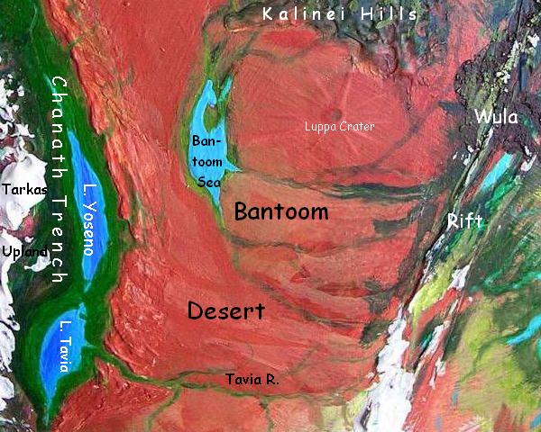
A few hundred km southwest of this Kalinei Hillbilly Complex lies its opposite, an oasis called the Bantoom Sea--a lenticular, shallow, brackish bedlake, 500 km (300 mi) long. Though it lies only 320 km (200 mi) from the lip of Chanath Trench, and fossae (straight cracks) in the crust near the lip do hold canyon-streams that are slowly cutting their way toward the Sea of Ghek, the Bantoom Sea won't be flooding Chanath Trench any time soon. The remaining 200 km is a red desert plain, nearly rainless. The only streams feeding the Sea come from the east--the Kalinei Hills and other slopes of the Wula Rift. Spring snowmelt and summer thunderstorms there keep the water level in the Sea fairly level year-round, unlike many of these shallow bedlakes with no outlets; instead of sterile flats of salt or alkali mud, a narrow strip of wooded, reedy shore surrounds the lake, where thotters and centahs and large plains wingbok live in relative prosperity.
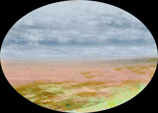
To the south, the Bantoom Desert stretches on and on: a million square miles of Mars! Dusty red plains; life only in the rare canyons; and few people of any species. A few nomadic bands of plains wingbok graze the plateau in spring; flyote families nest in the few canyons with year-round streams.
The only large oasis is invisible 'til you're right on the brink; if we detour east over the red plain for a day or two, low ridges start rising from the dust and rubble. They converge ahead in a low wall; nothing much. And then you crest it and the world drops away... Luppa Crater, a bowl 1.7 km deep (over a mile), 90 km (55 mi) across. Yet the outer wall is quite unimpressive. This has ecological consequences: the low walls don't block winter storms, but the bowl traps snowmelt. So Luppa's an oasis of denser air, AND warmth in winter, AND water: in the center is marshy Lake Kalenn, 16 km across. The air's thick enough to support unusually large flyotes and plains wingbok so big they can speak in complete sentences. Thotters and pastoral centahs also live by its shores. I suspect if Kalenn had been bigger it'd be a major cultural oasis; as it is, the bowl just isn't big enough to support a big population. But it's pleasant.
Let's head south along one of the streams trickling down a valley between two of Luppa Crater's rays of debris. A few hundred km south, these fade away and the creek joins others from Wula Rift and heads west, for the Bantoom Sea. Should we follow? Ahead of us is just a windy steppe, stretching 1000 miles south to the thin polar icecap.
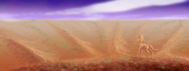
But let's not be hasty. Hike on south a few days--trust me! As we pass 50 degrees south, we're creeping into a rainier zone, where polar winds meet and fight their temperate cousins. Neither airmass has much moisture, but the resulting thunderstorms in summer and blizzards in winter feed sparse grass. It's like the high steppes of Mongolia or Alberta--though this land, the Tavia Steppe, is close to Tharn's "sea level." You spot large herds of dwarf wingbok in the distance, though they shy away from you--an unfamiliar species, a potential predator. Wingbok this small fear the new.

And then a gulf opens up before our tired feet: Tavia Canyon. Holes in the far wall, like the mouths of swallownests, mark cliff-houses of the southernmost flyotes on Tharn. The Tavia River, like the Ghek far to the north, drains down into Chanath Trench; with such a drop, it's cut a thousand-mile gorge longer and deeper than the Grand Canyon. Down in the canyon, out of the endless wind, patches of dark forest cling to cracks and border the beanfields of the resident flyotes. The first trees and towns--well, cliff-pueblos--that you've seen in a week!
The Tavia drains a great tundra plain to the south--cold, windy, as dusty-rose as Mars, with pale dry bunchgrass only in snaking stream-channels, but lurid lichens on every rock. Only nomadic mamooks live there, and not many of them--creatures weighing up to twenty tons would graze those sparse plains bare if they settled down.
In the orbital photos you'll notice an odd pink fringe to the south polar cap. It's not just haze or dust. The prevailing winds here are off the south polar cap. Yes, when a dry "storm" rolls in off the desert, fine red dust drops on the ice, and this can create a salmon-colored snowpatches the size of small countries, visible from space. But the unnatural pink you see is a further step: bacterial staining. Anyone in sunny snow country where pits develop in melting snowbanks has seen patches and streaks of such bacteria, but on Tharn these colonies, nourished by the dust, can run for miles.
I've often wondered if some of the vivid colors in the "topo terrains" near the poles of Mars are bacterial. Admittedly, bacteria there would face radiation and cold much worse than Tharn's.... but that's all the more reason not to be surprised by Tharn's miles of "watermelon snow." These Martian-looking icecaps are friendlier to life than Antarctica or Greenland--no colder, and far richer in nutrients from that good old Tharnian dust...
World Dream Bank homepage - Art gallery - New stuff - Introductory sampler, best dreams, best art - On dreamwork - Books
Indexes: Subject - Author - Date - Names - Places - Art media/styles
Titles: A - B - C - D - E - F - G - H - IJ - KL - M - NO - PQ - R - Sa-Sk - Sl-Sz - T - UV - WXYZ
Email: wdreamb@yahoo.com - Catalog of art, books, CDs - Behind the Curtain: FAQs, bio, site map - Kindred sites