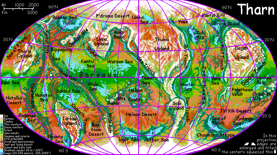
THARN:
Tars Triangle
by Chris Wayan, 2005-6
Map, Tharn's homepage, Peoples of Tharn, Regional tours, Geology and Evolution, gazetteer, terms explained. More worlds? Planetocopia!
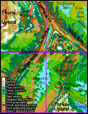
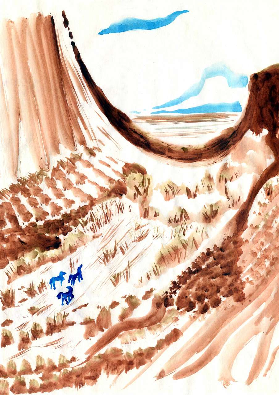
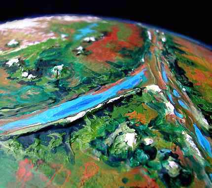
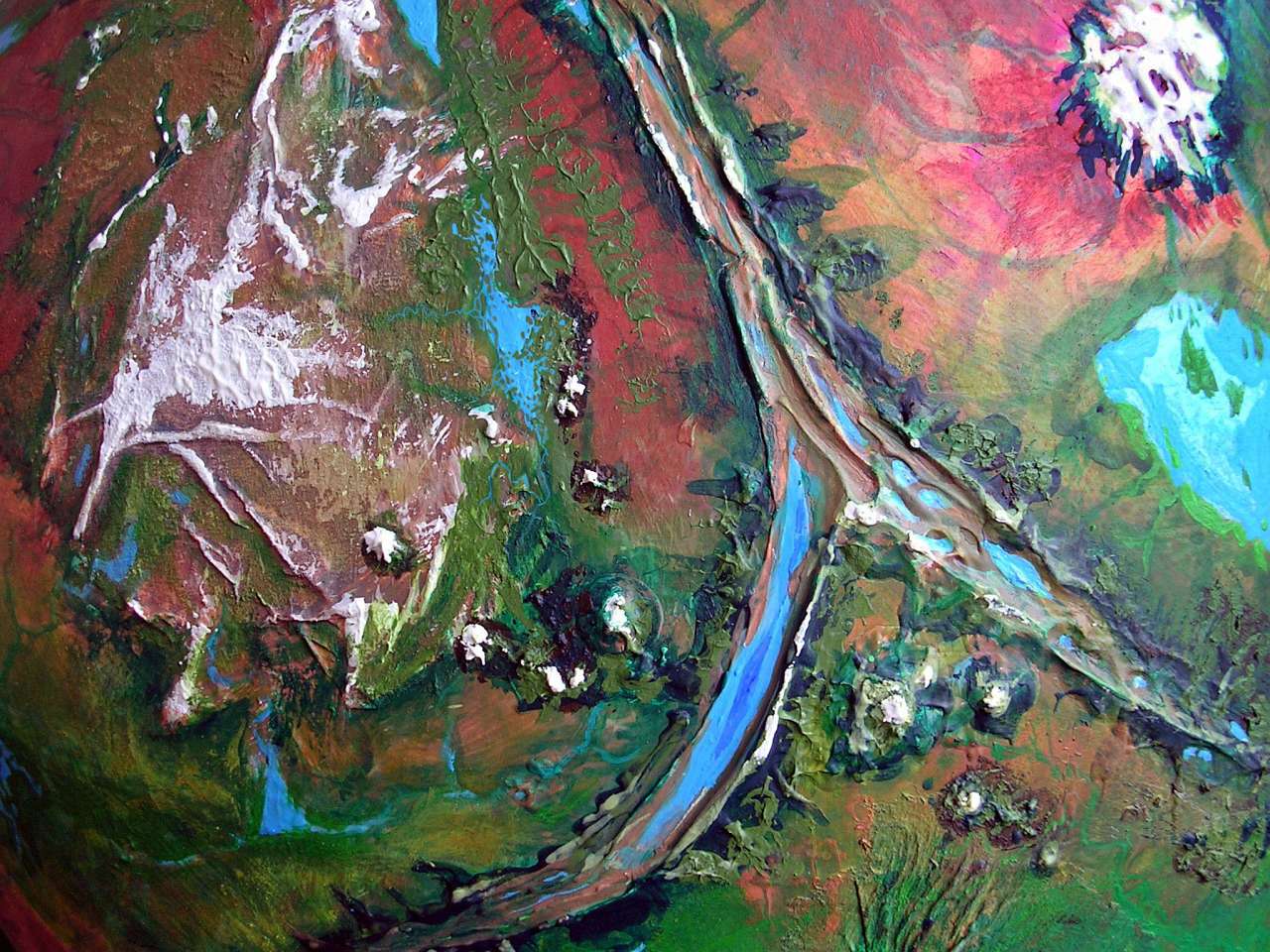
Tars Triangle is a fractured wedge of land between the Wula and Thurian Rifts, north of Tarkas Upland. From the upland, a great dorsa (compression ridge) stretches north: Chornis Ridge. From its tip radiates a fan of long ridges, the Manacha Fan; beyond, in the wedge where the two rifts meet, great volcanoes rise, some Himalayan in height.
Over the ridges flanking the rifts, down in the rift valley itself, lies the largest riftlake on Tharn, strange, bubbling Lake Felka. Northwest of the junction, more volcanoes rise above great marshes and deserts. To the northeast, a desert plain shades into a rich prairie around the Rippagong Sea.
All in all, this region is rugged and dry--the harshest land in the equatorial belt, and one of the least populous. But the slopes of the great volcanoes catch rain, creating ecological islands. Upland peoples have settled their microclimates; living so close to plains species, they've traded far more. Complex hybrid societies now ring these mountains, stratified by altitude and species, not by social class.
But aside from the volcanoes and the fertile shores of the Gathol and Manator Seas, Tars is mostly scrub, desert, swamp, and thin evergreen forest--all with thin populations.
Tarkas Upland, to the south of Tars Triangle, is the largest southern highland, about the size of Australia. From its northern tip stretches Chornis Ridge, a single straight dorsa 3-4 km high, running nearly 900 km (560 mi) north from Tarkas.
The far end of Chornis frays into a whole fan of lesser ridges, Manacha Fan, running another 900 km to Mt Ikos. The ridgetops, from 5 to 50 km wide (3 to 30 mi) wide, are alpine or subalpine; the faces are steep, in places sheer. The valleys between are semi-arid grass and scrub, with some trees in sheltered cliff-bays and along streams. flyotes dig cliffdwellings into the ridge-faces and farm the valleys beneath; above them, camaroos herd and farm. In orbital winter you may even see a marriage party of gigantic mamooks lumbering by, on their way from the tiny, insular colonies atop the Tars volcanoes to the broad Tibetan plateau of Tarkas. To them, the dorsae aren't a barrier but a highway of cooler, bearable air.
From Manacha Fan west to Thurian Rift lies a savanna 500 km wide, Manator Veldt. Groves of "acacia" and "oak" at the north end thin to lone trees dotting a hot African veldt to the south around Manator Sea---a narrow, broken sea 1600 km long but never more than 270 wide (1000 by 170 mi). Its shores are Mediterranean in the north, growing steadily drier to the south, where the sea and its trough trail off in a long string of brackish desert lakes stretching nearly to the subpolar Ghasta Sea. Northern Manator Veldt has a rich mix of species: scaly bos in the shadier groves, graceful veltaurs and centahs and shy little wingbok on the prairies. Fishing and aquacultural villages of thotters line the few streams, and the shores of Manator Sea, especially in deltas and bays where rivers descend from the Thurian Rift Zone, discharging fresh water. Thotters can survive without it, balancing their salt intake with fish, parru eggs and aquatic plants and fruit, but the ideal village site has both fresh and salt water.
The Manator Basin is pleasant, especially the north, but insular--all stay-at-home farmers, fishers and herders. The Shire, on Tharn? Given the rich species-mix, the area should be culturally advanced; multispecific societies consistently do better than monocultures like ours. I'm not quite sure why the Manator Basin is such a hinterland, frankly; but it is. Maybe it's just off the trade routes; most east-west caravans cross the Triangle north of Lake Felka, where there's only one great rift zone to climb over, not two. Or maybe it's the sophisticated volcanic city-states to the north, drawing off all the native innovators and misfits, leaving Manator as conservative as Kansas.
West of Manator Basin is Thurian Rift, a very long chasma (a sinuous double ridge where new crust is spreading) curving southeast from Tars Triangle all the way to the edge of the south polar cap. Its flanks are a fractured maze of ridges up to 3 km high (2 mi), with fossae (straight cracks) forming canyons at right angles to the rift, like railroad ties or millipede legs. No wonder caravans detour around this rugged zone! Still, the fossae shelter forests and send streams down into the plains. One species new to us has settled the canyons: mops, a flamboyant race of feathered velociraptor-like forest people. Picture giant flightless cool-weather parrots with hands, and you won't be too far wrong.
On the other side of Manacha Fan, to the east, lies another broad shallow lake, the Gathol Sea. Its basin is rainier, due to storms straying in from the rich Barsoom Basin over the low ridges of Wula Rift. So the Gathol Plain east of Manacha Fan is distinctly greener; it's open forest from the ridges down to the shore.
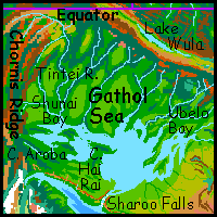 Surprisingly, the species-mix is nearly the same as Manator Veldt, just denser, especially forest species like bos. Fewer wingbok, but then they're dry-veldt specialists. Not one new species joins the mix. The reason is simple; bos are the only Tharnian people evolved to exploit tropical forest. Though biologically rich, such forests aren't large on Tharn. And becoming purely arboreal isn't wise, for these equatorial woods are drier and opener than Terran rainforests; in most, you can't just swing from tree to tree. On the other paw, Tharn has immense savannas, uplands and deserts; so more intelligent species have evolved to exploit them.
Wait, I lied. There are indeed true arboreal peoples on Tharn--lebbirds and arthom. They're just winged, and thus restricted to the thick air of the trenches. Though, come to think of it, Tars Triangle does have a ghostly artho presence; their only successful emigration caravan passed through Manator, detouring north from Har Trench round Manacha Fan on their way to Chanath Trench.
North of Manacha Fan is a fractured wedge of land between the Wula and Thurian Rifts, where the two-way compression from these rival spreading zones has created geologic confusion. A jumble of high desert basins, brackish marshes and thinly wooded hills, it's dry for an equatorial region: the ridges block storms in all directions. Confusing country, but you can never really be lost there: above it all rise four gigantic volcanoes, visible hundreds of km away. It takes some height to overcome Tharn's sharp curvature, but these cones deliver.
Heading north from Manacha Fan, the first peak to rise over the horizon is Mt. Ikos, over 8 km high (27,000')--nearly as high as Everest. It's just below the edge of the orbital photo. Ikos is really a range, not a lone peak: a long line of lesser cones, mere Fujis and Ararats, straggles across the horizon to the east.
As you veer west and round the knees of Ikos, a line of three more cones rises ahead. On the right is Mt Ethas, 7 km high (23,000'), taller than Denali or Aconcagua.
In the center, dwarfed by distance and by its giant neighbors, is Mt Akor, the northernmost and lowest of the Big Four. From orbit it looks like a mere dot, but even Akor rivals Kilimanjaro--it's 5.5 km high (18,000').
On the left is the long, massive, icy wall of Mt. Imal, highest and westernmost of the Big Four. Imal is about 10 km (33,000') high: as tall as Hawaii stripped bare of its sea, and far steeper. No sight on Earth can match it.
All four peaks have colonies of high-altitude and cold-tolerant species on their slopes, settled in rings and contour lines: mamooks on the snowy heights, camaroos in the alpine meadows, mops in the temperate forests and bos in the subtropical ones below them, plus the normal savanna species in the foothills: veltaurs, centahs and wingbok, plus flyotes nesting in the lava-cliffs and thotters along the streams. The trade and interchange among so many peoples with different viewpoints, cultures and technologies has turned each of the Big Four into a sort of diffused but cosmopolitan city-state. They don't make war like Greek city-states, but there's a definite cultural rivalry, called "peak-pride," which expresses itself best in a sort of artistic Olympics, the All-Ring Fair, held on the plateau between the Big Four late in orbital winter (so the upland species can endure the lowland heat--in the case of mamooks, just barely). Music, painting, text and picture-books, songs and poems, dances and plays all debut here.
But let's head north to the cusp of the Triangle. Beyond the volcanoes and the jumble at their feet, Thurian and Wula Rifts finally fuse to form Kantol Rift. Washboard ridges rise steadily, supporting thin evergreen forests on their raw new soil. Only mops and camaroos live in these rugged, lonely highlands. After the cosmopolitan volcanoes, it feels like Appalachia. This hillbilly country ends abruptly: dropping into the central rift valley.
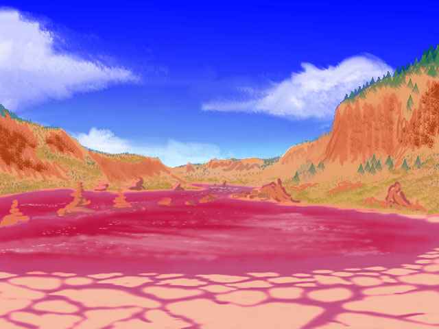
On the floor of Thurian Rift, just southwest of the rift-junction, lies Lake Felka. The biggest riftlake on Tharn, Felka's 1200 km long, though rarely over 100 wide. It's a deep lake for Tharn, up to 300 meters in spots; hot mineral springs feed algae and bacteria that stain Felka's waters purple and even flamingo-pink in late summer. Spectacular but unfriendly land. Some thotters do fish the shallows, but stick to a few villages at creek-mouths; even they won't drink that stuff. The great lake does moderate the climate, at least; it's hot but not a desert like many Tharnian rift valleys. Instead a long trough of savanna runs below the cliffs like a linear Ngorongoro, supporting modest numbers of veltaurs, centahs, and dwarf wingbok.
Thoris Upland rises west of Kantol Rift and north of Thurian. Thoris is big, some 4 million sq km (1.5M sq mi), meriting its own page; here, I'll only describe the borderlands it shares with Tars Triangle. Thoris is the lowest of the northern uplands, much of it only a few km above bedlevel, and lacking the abrupt "continental shelf" and "coastal ranges" of the other large uplands. It resembles an irregular pyramid of slabs, each a plateau of a different height, capped by straight, intersecting snowy ridges (dorsae), with an arc of volcanoes at its feet. Thoris's strange ridges seem to be a grander version of the compression fan seen in Tars Triangle. This makes sense, since Kantol Rift curves much of the way round it, squeezing it in all directions. Instead of subduction trenches, Thoris just crinkled, cracked and stacked.
Because it's the lowest of the great uplands, Thoris is a bit less barren. It resembles our Altiplano--dry-grass steppes broken by high snowy ranges. A wide rim of evergreen forest clings to Thoris's gradual slopes and terraces. It's sparse, cold and thin-aired, but paradise compared to the average upland. Thus, though the local mops and camaroos live scattered in hamlets (or nomadic camps, in the case of mamooks), the total population is surprisingly large.
Just south of Thoris lies Lake Guli, a triangular freshwater body about 300 km long (190 mi) and half as wide. It's fed mainly by the Omp River, which runs west from the Omp Mountains, and the Guli, draining the southern terraces of Thoris. Exiting from the lake, the enlarged Omp River flows 1200 km (750 mi) to the Kaol Sea. This valley is a tongue of the great Polodona Wood, a tropical forest generating its own rain; though it thins to groves and mixed savanna east of Lake Guli, the land on this side of Thurian Rift is notably wetter than Tars Triangle proper, and supports a dense bo/veltaur/centah/wingbok population. One strange new species joins the mix, though: lobbras. As the name suggests, they're a sort of land-lobster that fills a grazing niche, rather like Terran zebras. They look peculiar and speak with a strong accent (incomprehensible at first) due to their crustacean-like mouth structure. But they're sociable and mix well with other species. However, their range is limited to the basins between Thurian and Zor Rifts, for they can't climb the ridges. They're strong enough--but copper-blooded lobbras can't tolerate thin air. (Well, thinner air; the rich Guli Valley has no more oxygen than the summit of Everest.)
In fact the lobbras thin out as we head up the Omp River to its source--even the foothills are enough make them feel faint. The Omps are a volcanic range, small in extent but fairly high, with three sets of twin peaks 5-7 km high (16-23,000')--almost Himalayan, though they look more like Denali or Kilimanjaro--steep cones like the volcanoes of Tars Triangle just across Thurian Rift; both ranges probably arose in response to compression. Like them, they're ringed in settlements; but they lack the flamboyance of the Big Four, possibly because the lowlands here are more fertile. In Tars, the Big Four are the place to live, and shelter at least a few of every local species; here in the Omps, lobbras are conspicuously absent; downriver is just as cosmopolitan.
North of the Omps lies Tunol Marsh, a huge, brackish wetland east of Thoris Upland. Lake Tunol at its center is 640 km long, though never more than 100 wide (400 by 60 mi), though it's hard to say where marsh ends and lake begins. The marsh ends abruptly on the east where the Tunol Mts rise: a third chain of steep volcanic cones like the Omps. This is largely thotter country. To the north, Lake Tunol has a near-twin, Lake Mirlo, though its basin is cooler and more wooded. It differs culturally, too: it's the eastern tip of the range of elaffes, a tall, giraffish people who prefer temperate woods. Cultural interchange between the mercurial thotters and calm, slow elaffes is hard to imagine, but it does happen here; certainly they trade incessantly.
Between Kantol Rift and the Tunol Range is a long, narrow basin: the Tunolian Desert. No thotters, no elaffes, no anyone, except bands (not even herds) of dwarf wingbok, so stunted by altitude and drought that their brains a little large than a chimp's (though more efficient). They can talk, but probably won't; isolated and neophobic, they fear a strange creature like you. To the east, the desert slowly rises in broken ridges until it's high enough to catch sparse summer rains and winter snowfall, sustaining thin evergreen forests; mop and camaroo country. The central rift valley, though warmer, is desert and scrubland: the ridges on both sides cut off rain. Only dwarf wingbok again.
The east side of the ridge system is much the same, writ large: a wider plain, the Tlani Desert, and a far greater volcano, Mt Gholit, the summit of the Orovar Range, 16 km high (50,000').
But to the south the rift's slopes are greener, dropping to a fertile prairie where veltaurs graze and garden, and centahs herd their "ostriches" and "roos." No wonder it's greener: across the plain is the Rippagong Sea---just the first and least of a whole chain of seas humidifying the air of the rich Barsoom Basin.
World Dream Bank homepage - Art gallery - New stuff - Introductory sampler, best dreams, best art - On dreamwork - Books
Indexes: Subject - Author - Date - Names - Places - Art media/styles
Titles: A - B - C - D - E - F - G - H - IJ - KL - M - NO - PQ - R - Sa-Sk - Sl-Sz - T - UV - WXYZ
Email: wdreamb@yahoo.com - Catalog of art, books, CDs - Behind the Curtain: FAQs, bio, site map - Kindred sites