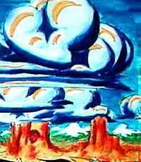
Venus Unveiled: Central Aphrodite
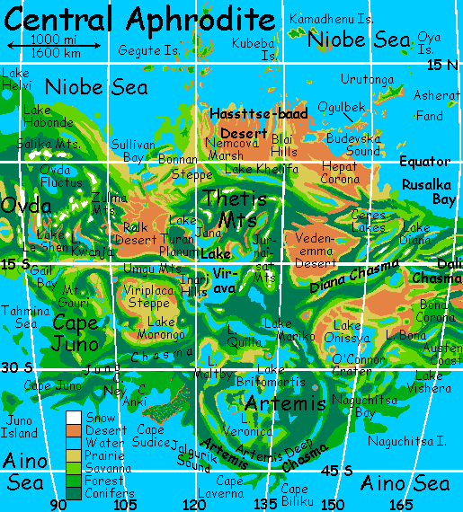
APHRODITE is a huge equatorial continent shaped like a scorpion, winding halfway round Venus, containing half its land. Aphrodite's main regions are:
You're in the mouth of Diana Chasma on Rusalka Bay, hovering on the updrafts (you did read the orientation, didn't you? In Venus's dense air, strap-on wings are all you need to fly). From here, all flyways enter Central Aphrodite. Which way first?
We could head northwest along the coast, past Ceres Corona, until its canyons, lakes and snowtipped peaks fade into the Hassttse-baad Desert (no, my keyboard's not sticking, why do you ask?), full of long mysterious gashes hiding waterholes, and old lava flows, and hill-regions like Hepat and Blai that are called coronas but have suspiciously caldera-ish craters near their summits--are they really low shield volcanoes? The Hassttse-baad Coast is a geologist's dream, but forbidding to the casual tourist--3000 km of dust and tedious ridge-climbs and oasis-hunts.
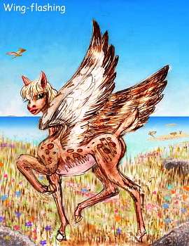
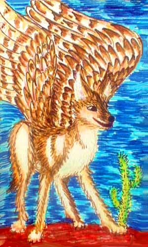
Offshore, and more inviting, are the Urutonga Isles, a triangular archipelago 1200 km across. Its southern isles near the desert coast are just dune-grass and brush, inhabited only by a few leopards running roo ranches, and large bands of winged antelope, who follow the sparse rains from isle to isle, semaphoring messages with their wings. These beautiful but terribly shy people are not easy to meet on a whirlwind tour like this; due to their deer-heritage, they're slow to trust strangers. Civilization is all very well, but instinct says you might bite.
As you ride the daytime updrafts north through these rocky isles, they blossom from red to brown to gold to patchy green. The climate, shaded by the equatorial rings, is warm but not often hot. Dry winds often blow off the mainland desert, but they're cooled by 500 kilometers of water: Budevska Sound. Even the long, narrow capes bracketing the bay east and west are merely semi-arid, influenced by the maritime air.
The largest and northernmost island, Urutonga proper, catches more storms off the Niobe Ocean, sustaining savanna and permanent streams. Here there are large prezebra herds and even a few megaparrot villages along creeks where their orchards do well.
The sound's a great bird-haven, and whales calve in its warm shallow waters, like Scammon's Lagoon on Terra. All the islands are rugged, rising in cliffs and stacks from the turquoise sea... Great flying, great swimming...
Nah. Let's not go there, either. Aphrodite's huge--even sticking to the tour, it'll take weeks!
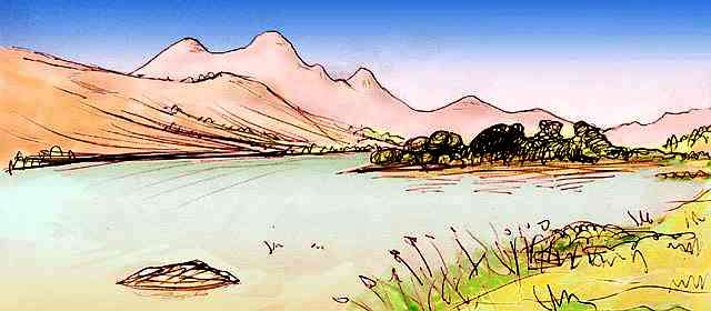
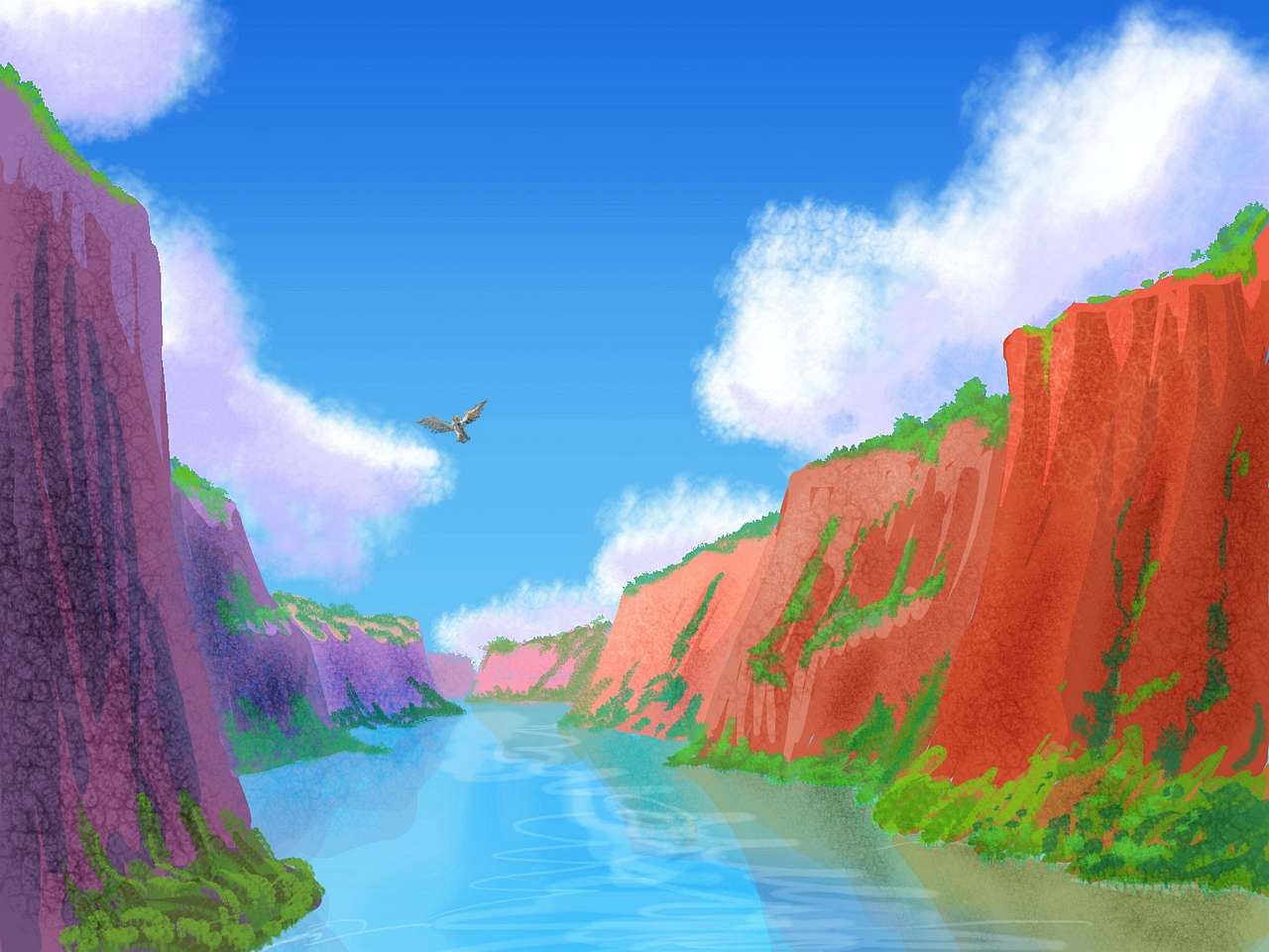
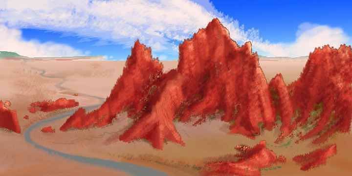
Our path lies inland--up Diana Chasma a thousand kilometers or two. Long desert lakes reflect the snowy peaks two miles above them. Streams descend in pale white-water ribbons from alpine meadows and dark pinewoods through a sagebrush belt to the strip-oasis of the lakeshores...
Flying, sleeping, flying, sleeping, as the sun sets slowly behind us, we creep into Aphrodite's dry heart. The woods and snows slowly thin on the ranges looming above; the lakes shrink and the grassy shores turn dusty. In dusk, we fly on, grateful for the cooler air. Over the ridges to the north is grim Veden-Emma Desert, about the driest on Venus. Basins like this usually cup great lakes, but Veden-Emma is near the dry equator and cut off from sea-winds in all directions, so only a few salt ponds break the desert. It's a bad place to fly even at night, but deadly in sunlight--not so much for sheer heat, for it's high desert shaded by the rings, but because the few springs dry up during the week-long day.
We'll turn south instead, into the Onissya Basin. Fed by occasional storms off the Aino Ocean, Onissya holds a shallow, brackish, reedy inland sea some 1000 km across--comparable to the Caspian. Lake Onissya's shores are marshy and mobile--the lake swells and shrinks like a beating heart, though it's hard to predict what the climatic cycle will be. Around the lake is a wide grassy plain, desert in the north where we came from, greening a bit in the south.
We'll camp out in the lake, on O'Connor Island, near the west shore. O'Connor was formed by an impact crater, with a central lake inside the crater walls--a ring-island more Martian than Cytheran. Though on second thought, since the water level of Lake Onissya will fluctuate and the shoreline is so uncertain, O'Connor's a toss-up between a cape and a true island. Maybe it alternates, like Mont St. Michel. We'll camp by the inner lake and not worry about it. If you're from Mars, you'll feel back home. Good old craterlake! Just ignore the rings in that pale Cytheran sky.
The name Onissya, by the way, comes from a second crater near the center of the lake, drowned too deep to form an island (I think). Many basins and plains have never been assigned official names of their own; researchers of my century were naturally focused on rugged features which stand out in radar scans. So many of these great lakes and bays are named for the craters they flooded.
To the west loom the dark pine-topped ridges of Artemis Corona, but we have a side trip to make before going there--1000 km east and south, over steadily greener hills, past half a dozen of the Mayauel Lakes, including Mayauel itself ("My! A well!")--a mere 60 km wide and only 400 long! After Onissya, it's nothing. Still, this is one of Aphrodite's pleasanter regions--not spectacular, but with moderate rains, quite Terran landforms, and a warm mild climate.
You might even meet genuine humans around here! The classic, unimproved model. They find the climate ideal--much like Terra used to be, before they trashed it.
I know they look funny, but try not to point.
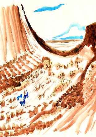
At first, as in the sketch, the hills are sweeping grassy fells, with trees only by the lakeshores; but slowly they thicken to cover the hills as we slope down at last toward the Aino Sea. Ahead is huge, shallow Lake Vishera, a close twin in size and shape to Lake Victoria in Africa, and probably just as rich in islands.
Wide grassy plains surround Vishera's marshy shores. The coastal strip between the lake and the Aino Sea is a mix of woods and meadows, though inland, the land gets scrubby and dry before it rises to piny heights--the bent-back tail end of Dali Chasma, where it twists around the hills of Bona Carona. Remember it from the East Aphrodite tour? We've nearly come full circle--minus a few hundred km. Sorry! It's hard to explore such a twisting, tricky supercontinent without meeting yourself now and then.
We follow the south coast back toward Artemis in the predawn light. Here too, the gentle land feels unlike most of Aphrodite. Ahead is Naguchitsa Bay, a twisty triangle 600 km wide but narrow-mouthed, nearly blocked by Naguchitsa Island (250 km long) leaving east and west passages to the Aino Sea. West of the bay loom the dark pine-topped ridges of Artemis Corona--and this time, we climb over at sunrise, into another country.
Artemis is a gigantic ring of concentric ridges and rifts and lakes. At 2500 km wide, it's the largest symmetrical structure on Venus--on any planet known, unless you count the Great Red Spot.
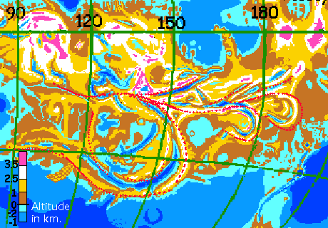
At first glance you think "impact feature" (or if you're an under-granted cynic like me, "well-funded cyclotron"), but Artemis is deeply tied into the web of ridges and chasmas stretching the length of Aphrodite, so it's probably an upwelling or downwelling--a monstrous corona. But to the east, lesser rifts like Dali and Dzyzlan Chasmas loop and trail, echoing Britomartis's pattern as if it left a wake.
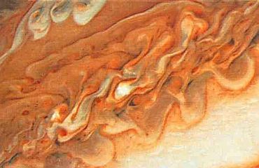
My mention of the Great Red Spot wasn't casual--the chasmas here look a lot like the whorls of laminar flow around and downwind of the Spot. Only these features are swirling in stone! And I'm not, so far, convinced by any of the geological explanations for this pattern of diminishing echoes rippling east. A continent-sized wave pattern? What's going on here?
And Artemis Deep, the crescent-shaped sound paralleling the south coast range, looks quite like a Terran subduction trench and island arc, though that's as lame a comparison as Hellas Basin or the Red Spot. It's probably a spreading zone like our African Rift. But circular? Weird.
In any case, whatever the geologic storm is that's causing it, Artemis Chasma is extraordinary--deep, narrow, mountain-flanked, and curving in a near-perfect arc for over 4000 km.
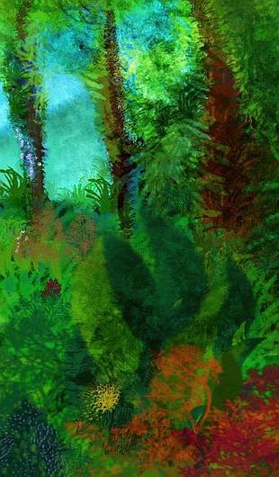
What's more, the setting is gorgeous. We've reached, at last, the edge of the southern rainbelt. The Aino coast and the ridges lining Artemis Sound have tall redwood and cedar forests. Around the mouth of Artemis Deep, where storms can penetrate inland, these woods are hundreds of km wide. Inland the land gradually dries to savanna, then prairie, then semi-desert, except on the many wooded ridges. The north is mostly dry hills.
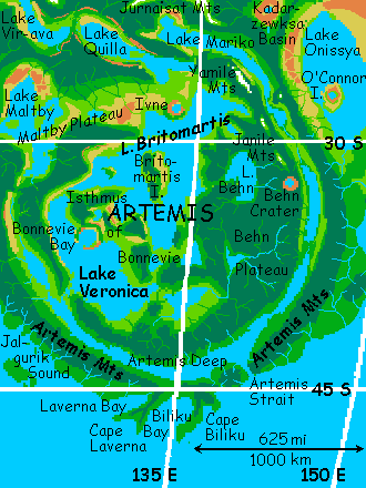
But the drying is slow and uneven, due to an unexpected factor: the Great Lakes. Now I've called other lakes on Venus great, when they compare with Terra's biggest. But this belt of Great Lakes like Britomartis, Veronica, Maltby and Virava, is a maze of land and water unlike anything Terran. Over an Australia-sized area, one-third of the surface is lake water, one-third highland forest, and one-third lowlands--marsh, desert, and lakeshore. The lakes often lie in rift valleys with bare rock walls, or in desert basins cut off from sea-winds, but that much water creates its own climate--the lakes generate rains that green the shores and the highlands southeast of each arm, and the wooded hills send streams back to feed the lakes...
Let's start at Veronica Strait in the southwest--or perhaps it's a very short river. Huge Veronica Lake, beyond, takes a couple of hours to cross at full speed. Two arcuate capes rise into view at last: Bonnevie Bay, an impact crater 70 km wide at just the right altitude to form a great round bay on Veronica's east shore. The north slopes are dry--the first hint of the inland deserts to come. Still, Bonnevie Isthmus is mostly fertile--a warm, oak-hilled, twisting strip 700 km long and 200 wide. Or is Bonnevie a peninsula, not an isthmus? Or an island floating in the Veronica-Britomartis Sea? Are those rivers or straits in the southeast and northwest? Can't be sure yet.
Two hours' flight north, beyond one of the strait-or-river-valleys, is the Maltby Plateau, a high desert of sage and scrub with open pine woods on the hills. In its heart is Lake Maltby, Texas-shaped, and nearly Texas-sized.
But instead, we wind east through rolling hills an hour or more, to the shore of Lake Britomartis. It's certainly one of the largest on Venus, and may be the largest--Lakes Veronica and Britomartis may be linked by any of three narrow channels--hard to be sure. The complex is larger than the Caspian Sea on Earth.
We head northeast, up a strip of indigo water in the middle of Lake Britomartis--a flooded chasma over a mile deep in spots. We sleep on Britomartis Island, 300 km long. We fly all morning due north over the island, then the lake again, six hours, crossing a narrower island and another hundred km of deep water before the mainland reappears: a curving rampart. It's Ivne, a second impact crater, this one forming a peninsula cupping a perfectly round lake. From Ivne's bare black obsidian ridge we can see snowy mountains shimmering beyond the eastern horizon--the Yamile Range, harbingers of things to come. Under the sheltering penumbra of the rings, snow is (just) possible again.
An hour north over prairies studded with oaks, and Lake Quilla appears--a flooded east-west rift valley 1000 km long. We sleep on Quilla's shore.
At last, a narrows that keeps narrowing. Quilla pinches off, and we're in Virava Chasma, cutting deep into the uplands of Thetis. The last of the Great Lakes, Virava, is the biggest on Venus--unless Veronica and Britomartis are one lake, and even then, I'm not sure. Virava's a mad twisting octopus, never more than a couple of hundred km wide, often no more than fifty, but end to end, it's 1800 km long.
Again, the rift-slopes are dry, often bare red rock. Cut off from sea winds by high ridges in all directions, the climate should be harsh and continental, with hot days and chilly nights. But the equatorial rings shield Thetis from the worst of the sun, and Lake Virava, fed by so much runoff from Thetis's mountains, moderates the temperature swings and humidifies the air. Streams run down into side basins too, creating smaller lakes or marshy oases everywhere.
It's noon now, and getting hot. We've been following rift lakes for what, three days? Four? Time to climb into the highlands of Thetis. We ride the winds east, up into the Jurnaisat Triangle, a wedge of mountains cut off from the rest of Thetis by Lake Virava. Jurnaisat's all pine forests and alpine meadows; to the east, it drops abruptly into the dry Veden-Emma Basin. That slope is bare rock, but for a few streambeds from the highlands, which dead-end in the desert.
But we're two miles higher, riding mountain updrafts in a zigzag north until we reach Thetis proper. Like Jurnaisat, it's an ecological island--aspen and fir and alpine meadows, sending streams down into the Great Lakes in their rugged canyons. Flowers carpet the high meadows, for it's Thursday, high summer.
At last, we reach the great drop-off. Far below us to the north, hazy in the heat, is long Lake Khelifa; the faint dark line on the horizon is the Khelifa Range, the last spur of the highlands. Beyond are only the Bonnan Steppes and the Nemcova Marshes bordering the Hassttse-baad Desert. You think I made that name up, admit it! Wrong.
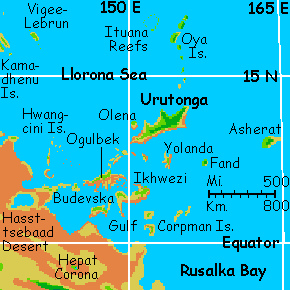
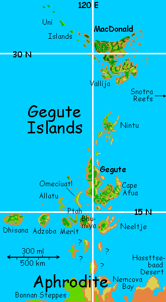
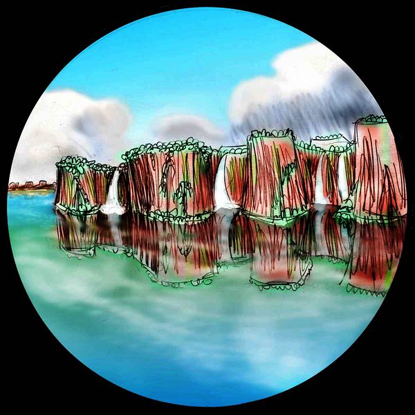
If we had time, it might almost be worth flying 1500 km north over desert, steppe, and sea, to the Gegute Islands, a subtropical chain over 2000 km long and nearly as big as Madagascar. They're as isolated as the Galapagos, but much more dramatic--heavily tesserated. Most of Venus's tessera are located in wet zones, creating jungle plateaus much like Roraima or misty crags like Guizhou. But Gegute looks like a movie set for a desert island--a maze of deep shady canyons full of pools and creeks, below the soaring red and black walls of a thousand grass-topped mesas, all wrapped in sunny beaches and coral seas.
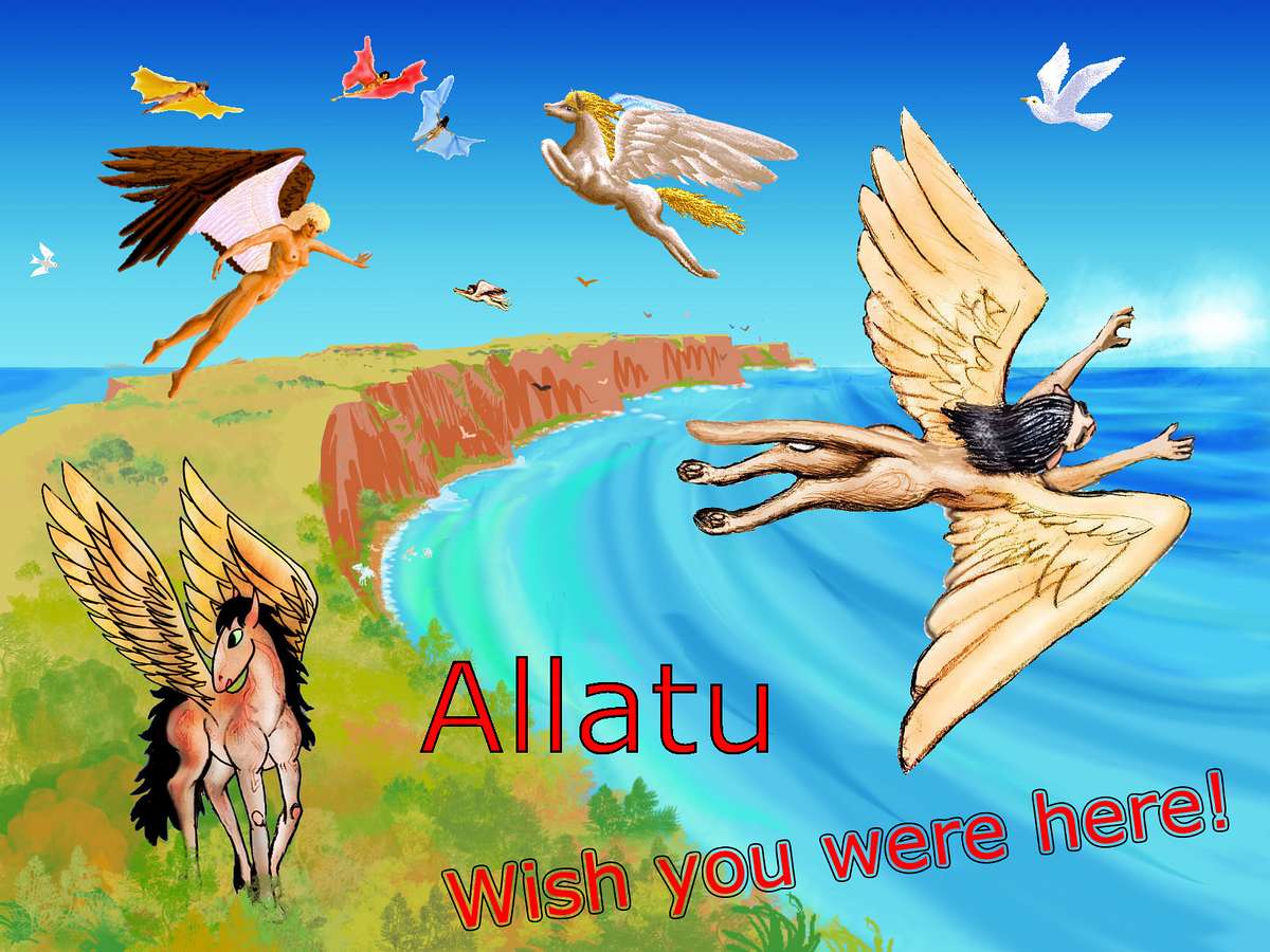
Rugged Neeltje, jagged Ptah, and wiggly Allatu, even Gegute itself look as surreal as Roadrunner cartoons, but as you go north, isles like Nintu and huge MacDonald are greener, more Polynesian fantasies, leading toward the mad Cretacious feverdream of Tellus. The Gazetteer has more on the Gegutes, but I'll give one example I'm especially fond of: bizarre Allatu, a grassy, cliff-edged runway meandering 200 km through the sea, like some Terran river-canyon in reverse. Allatu's curving cliffs shelter great coral bays. The island's too steep and windswept for many trees except at the cliff-feet, but these form fertile arcs stretching miles, behind coral-sand beaches. Beside the swimming, Allatu's a fliers' mecca, as the western cliffs face into the prevailing winds, creating a 200-km front of updrafts. Winged coyotes, ravens, angels, tourists and sphinxes dive and dodge in the endless aerial ballet.
Allatu, or Al-Lat in some spellings, was one aspect of the Threefold Goddess as worshiped on the Arabian Peninsula, before successive waves of patriarchal monotheistm demonized her (along with everything else female and/or fun). She was the moon-goddess; the crescent moon and star were her emblems. You still see them all over the Islamic world, but how many know what they really mean?
Oh well, in a thousand years our religions will either have drastically evolved again, or died well-deserved deaths, like most of our current institutions. Maybe Cytherans will bring her back.
We could go even further off the flyway. We could try the Snotra Reefs. No, I didn't make Snotra up either. The goddess of, well, never mind. In fact, let's skip the whole detour. I hate the Hassttse-baad Desert! Endless. And the Nemcova Marshes aren't much better unless you're a masochistic entomologist. Mosquitoes may be illegal on Venus, but thirty billion gnats up your nose is still no fun.
Let's just hang a left and skip it all. Stick to the green highlands--and that means climbing to the Turan Plateau.
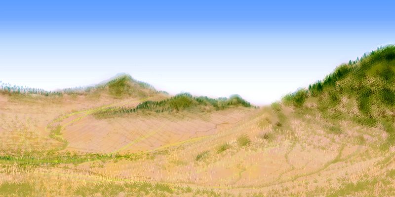
You cross Lake Jana in its deep chasm. Caution!--at right angles to the prevailing winds, these cliffs and slopes have some turbulent downdrafts on the west side. Before you rise the crags of Turan. This highland's a gigantic tableland between Jana and Virava Chasms--a cliffwalled mesa 500 km wide and two or three high, reminiscent of the great plateaus around the Grand Canyon. Stands of aspen and conifer cut off abruptly at the brink.
But the Grand Canyon's rocks are porous limestone and sandstone; the forests above it have no streams, for snowmelt sinks directly into the ground and emerges in springs a kilometer down in the Canyon. Turan, in contrast, is basaltic, like most Cytherean rock; slow creeks meander to the cliff-edges, and fall in long plumes. No doubt in a million years or two, these new streams will wear even this tough rock down into mere rapids and hanging canyons; so enjoy the lacy falls while you can.
Once you crest the cliffs, the aspen-wood floats like a green-gold raft on the redrock sea of central Aphrodite's deserts. A big raft: the sun's low in the east when we reach Turan's end. Another lake-filled chasm--this one the western arm of Lake Virava. Mind the cliffs--the abrupt change to a near-maritime climate causes downdrafts as well as updrafts. Launch out over the chasm--we still have an house's flight before we make camp.
Due south over the lake-arm are the Inari Hills, our goal, a corona of scrubby pines. Lower and drier than Turan, and with few creeks, it's not friendly country, but the best we can get. For to the west is Ralk Desert, a rough square 800 km across--no place for fliers to casually cross. It's high desert, with dry grass in the north, where it's open to the coast, and brushy hills inland, where only a few intermittent streams descend from the highlands of Ovda and Thetis and the Ralk-Umgu Range to the south, feeding small lakes and marshes around the rim. The heart of the basin is dead--naked red hills, black lava flows.
There's one small ecological island, the small, steep Ralk Mts, in the center--an orphaned bit of highland forest sending streams down to die in the desert. But really, the highlands are the problem. The mountains on three sides cut off Ralk from rain--it never had a chance.
Think of Ralk as a historical preserve, the closest thing to an untouched patch of the old Venus--just 400 degrees colder! In a way, the climate's harsher now--at least the heat used to be constant. Ralk now goes from quite hot in the day (unusual in this equatorial region shaded by Venus's rings) to quite chilly at night. Lit now by sunset, it looks like a valley of fire. Among sapient species, only winged coyotes live there--but then, they live everywhere.
We'll push south instead, from Inari Corona into the Viriplaca Steppe, another landlocked basin. Cut off from storms by the ridges of Juno Chasma and Boszorkany Dorsa, Viriplaca resembles Texas--800 km of wide, dry, grassy plains. Viriplaca was luckier than Ralk in its placement--if it were on the equator, it'd be utterly dead, but here, it gets a little rain from the south. Still, the ridges are sparsely forested, and the plains are treeless, except a few thickets in the south around the marshy inland sea of Lake Morongo, 350 km long and 150 wide. But at least there's life--and water.
It's a dull flight over dull country, but safe enough in the cool night air, following the shallow Morongo River. We won't need to detour again for safety reasons. We're past the worst of the deserts now--West Aphrodite has a few dry rainshadows, but nothing like the harsh lands we've crossed (well, skirted).
South of Juno Chasma's mountains, the land quickly blooms. Storms off the Aino Sea keep this coast as lush as the shore of Artemis. For three lazy nights we sail west along this coast--pausing to admire the rainforested mesas of Cape Sudice, with ferny red cliffs above jungle canyons, then Anki Bay, where Sudice's cliffs rise straight from the water like a medieval castle. It's even crenellated--high blocks with gaps between, low sections like the archers' slits in medieval walls. Waterfalls pour from the gaps straight into the sea, for Sudice, unlike most tessera regions, ends abruptly in a sheer drop.
If Sudice is a remnant of an older, bigger tessera zone surrounded by later lava, what sheared the rest away? Or did it "erupt" from the middle of the lava field later on? Why? Geological conundrum! My pet theory: it's a waffle-maker dropped here by a sleepy breakfast god.
West of Anki Bay is Cape Ney, a great lava-flow now lush with forests. Then Ney Bay and forked Cape Gefjun, 300 km long, and Lake Gefjun--a half-drowned, asymmetrical corona. Then long Deloria Bay and the Tai-Shan hills... all mild, maritime, with gentle night rains.
I hate to slight such fertile land--I'd like to put names on every bay and island, but I can't. Gentle relief often gets ignored, on radar scans. Over a million square kilometers with only a handful of names, and uncertain shores! At least it's obvious what the subcontinent must be called: Juno. After all, it's largely uplifted by Juno Chasma and its spur-ridges.
Let's fly right out to Cape Juno itself. Twin capes really, each a steep wooded ridge with sea-cliffs dripping in vines and ferns. Between them, a deep indigo sound contrasting with the shallow turquoise sea outside--the sunken chasma.
These twin fingers holding the big blue pencil point at something offshore: Juno Island, like Sri Lanka in size and climate, though gashed down the middle by the chasma that created it. The Juno ridges go on south for 1500 km undersea, surfacing as the Copia Islands halfway, and finally re-surface as huge Cape Zemcirla and merge with the small continent of Lada.
But the gaps are too long to fly casually; and now that we've done the grim bits, we might as well enjoy the kinder side of Aphrodite. Our flyway is north! (You see how cleverly I've timed our tour. We flew west before sunrise--all the colors and none of the glare. Now that the huge sun's up and in our faces, we turn north. Congratulations, me!)
The first day is all low green hills--the Husbishags. They're surprisingly rugged for such a small range. Here, tessera take the form of rocky fins and steep wrinkles instead of the mesas common elsewhere. They look like the convolutions of a big green brain.
Midmorning, we cross a wide river plain, and climb into a cloudy, dark-forested range. A peak at the west end stands out: Mt. Gauri, highest in the Juno region. Snow? We're under the rings enough by now that snow's just possible, though I doubt it.
The Gauri Mts have a mild climate, but they do cast a rainshadow, so their inland side is a dry sagebrush valley--a last tiny outlier of the Central Aphroditean desert. Boszorkany Dorsa, the long ridge east of the valley, has sparser woods, and behind it is dry Viriplaca Basin--that dry, endless Texan prairie we crossed last night.
At noon we cross the windy marshes around Gail Bay at the mouth of the Umgu River, one of the longest on Venus, running 1600 km straight from the Inari Hills far inland along dry Ralk-Umgu Chasma, joining the shorter but larger Kwanja River from the north, and emptying here below us into Gail Bay.
Ahead, over the windy grasslands of Gail, the mouths of two steep canyons open--Le Shen Valley in the west, Kwanja Chasma dead ahead. We'll follow Kwanja north into Ovda, the highest, ruggedest region of Aphrodite. In my mind at least, the Kwanja River is the border of:

World Dream Bank homepage - Art gallery - New stuff - Introductory sampler, best dreams, best art - On dreamwork - Books
Indexes: Subject - Author - Date - Names - Places - Art media/styles
Titles: A - B - C - D - E - F - G - H - IJ - KL - M - NO - PQ - R - Sa-Sk - Sl-Sz - T - UV - WXYZ
Email: wdreamb@yahoo.com - Catalog of art, books, CDs - Behind the Curtain: FAQs, bio, site map - Kindred sites