SHIVERIA
by Chris Wayan, 2003
One of a series of alternate Earths, playing with climatology, evolution, and cultural geography.
Shiveria is dedicated to paleoclimatologist Jonathan Adams and his alarming Ice Age maps at http://members.cox.net/quaternary/
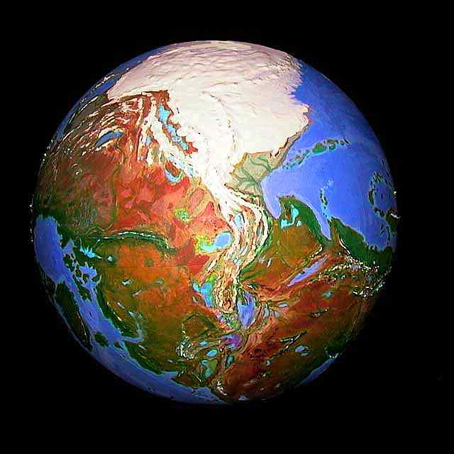
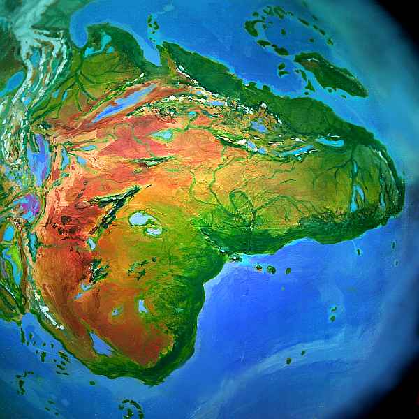
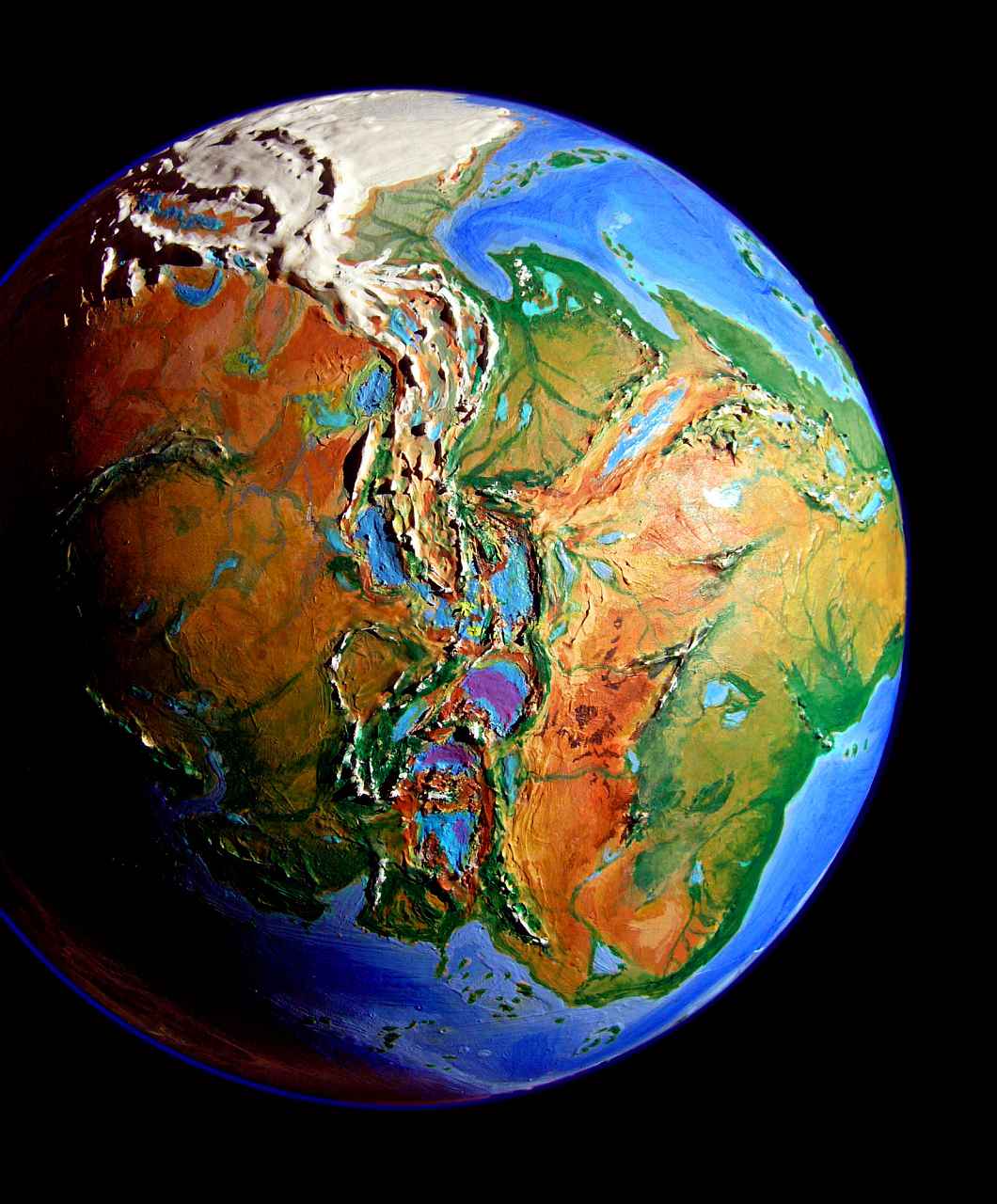
Just as an experiment, I tilted the Earth so both poles are on land. It wasn't easy--for in our geological era, the continents have drifted into positions so that nearly all possible axes have sea under at least one pole. I found only two tilts that worked, and chose this one, with the North Pole in the Amazon and the South Pole in Indonesia. The only alternative was to nudge our North Pole a bit, into either Siberia or the Canadian islands, keeping the South Pole still in Antarctica, if off-center. But this scenario resembled our real Ice Age so closely I decided against it. Been there, done that! I wanted something new.
I got it.
Welcome to Shiveria--the Earth with a permanent ice age.
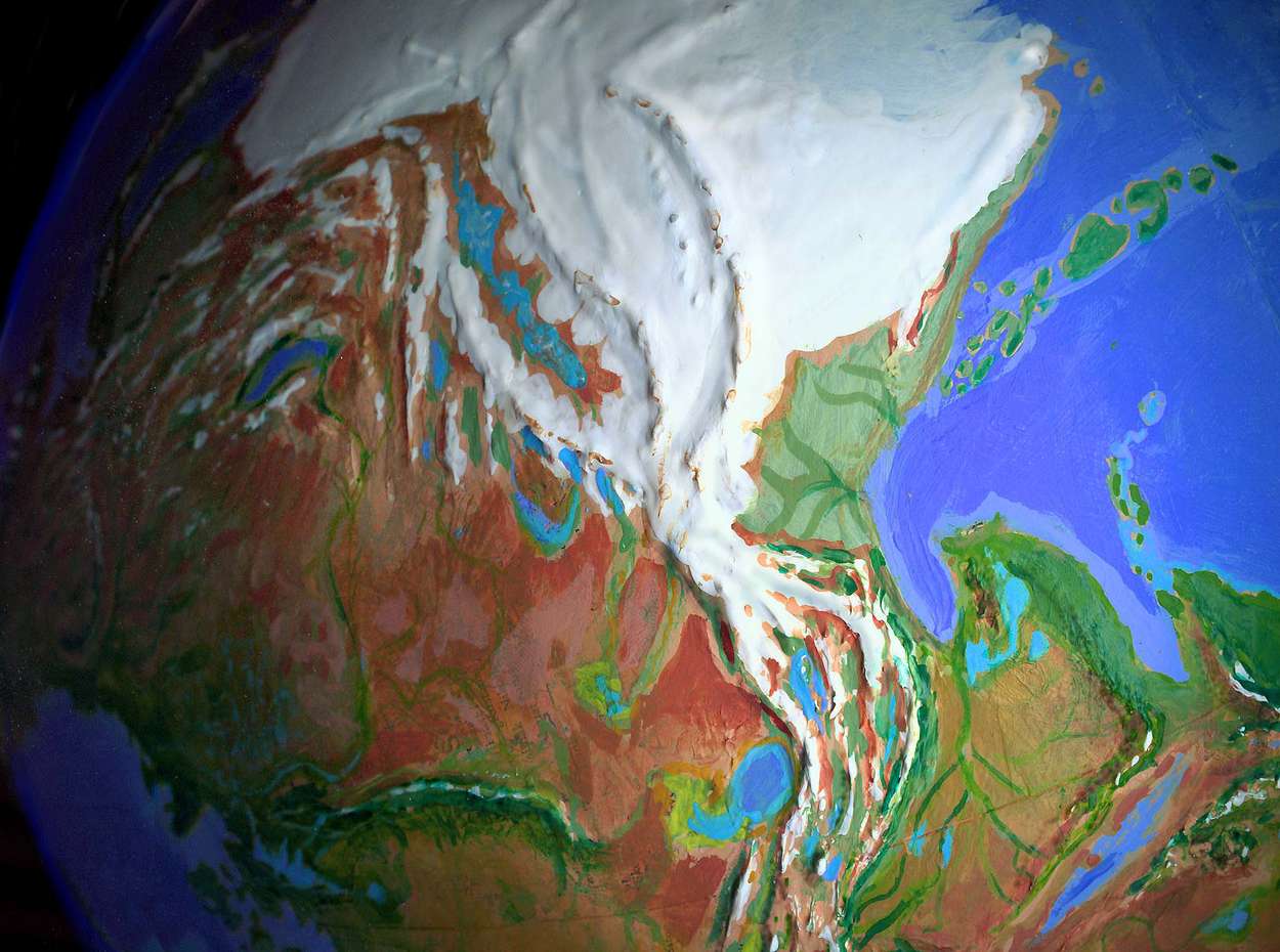
I haven't cluttered up the photos with labels and lines. But for clarity, I did remove the cloud cover. North is always up, except for polar views.
When charting Shiveria's coastline, I made a few exceptions to the 150-meter contour. Our polar regions were depressed by a thick ice-burden in our last Ice Age. But in Shiveria, where the ice is stable, ice-free lands will ride much more than 150 meters higher--Greenland's sunken interior will be an equatorial basin well above sea level, and Hudson Bay vanishes. For the huge new lands off Siberia and Alaska I used a modest 200-meter contour, since these lands had less of an ice burden in our history.
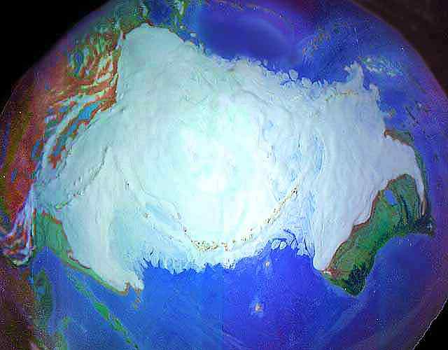
Antarctica is the least certain, of course. Our soundings have (crudely) mapped a complex land groaning under up to three miles of ice. Shiveria's "Antarctica" is equatorial, and without the ice burden, it rides up to 600 meters higher. Lower the sea 200 meters more, and the landmass could well be even larger than I've shown it, its bays smaller, its capes fatter, its islands more numerous--a huge, intricate new continent. But except for the mountains, which protrude from the ice and have been fairly well mapped, you can't trust my Antarctic geography much. I'm guessing from sketchy data. Almost anything could be hiding under there--we don't know.
Unfortunately, it now looks like we'll warm things up enough, in a real climatological experiment without controls, to find out exactly what's hiding under the Antarctic ice.
Of course, by that point, we may no longer care--if we're even around to look.
A TOUR OF SHIVERIA
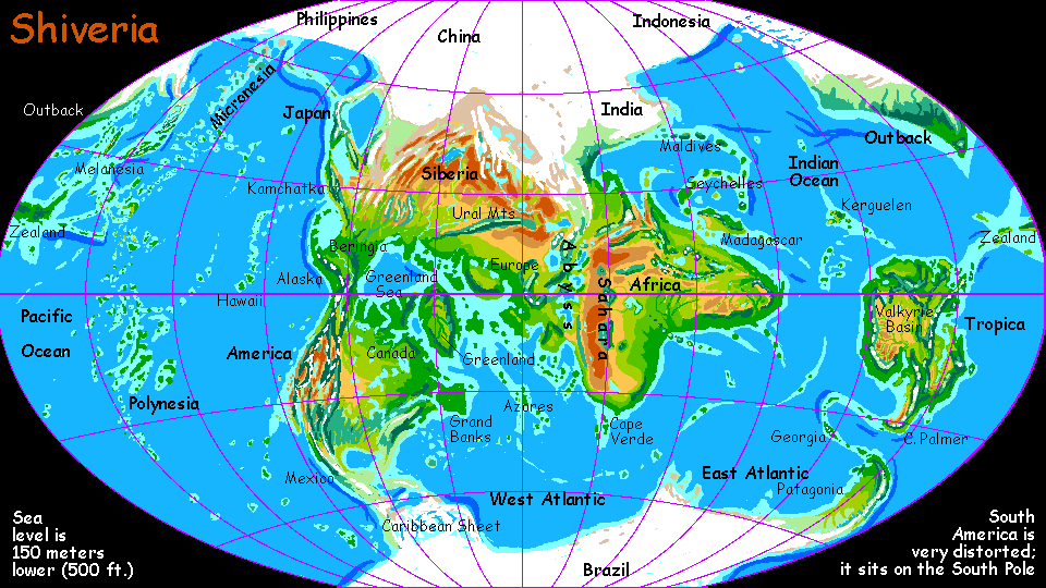
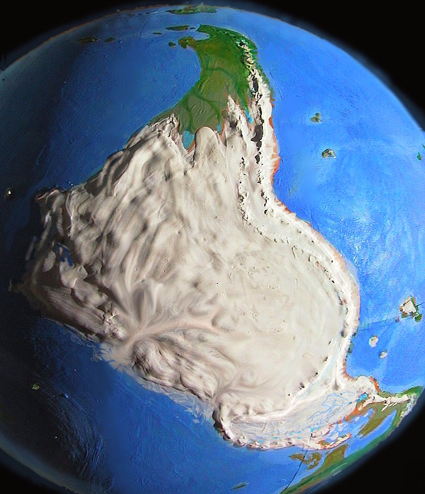
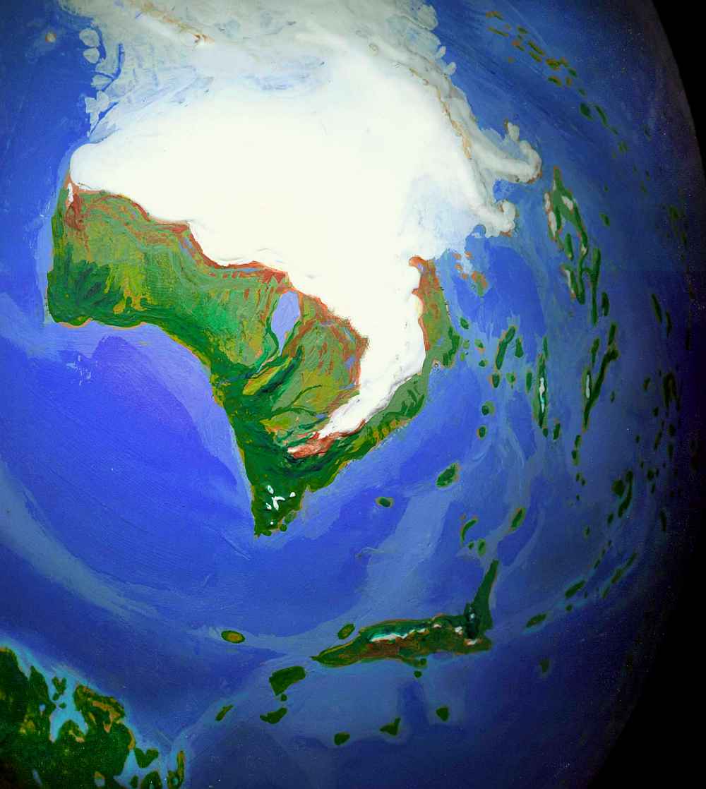
Our first stop: an equatorial continent nearly the size of South America. It seems wrong to call this Antarctica, meaning "south polar land"--besides, this ice-free continent is nearly unrecognizable. Let's call it TROPICA, based on its dominant climate zone.
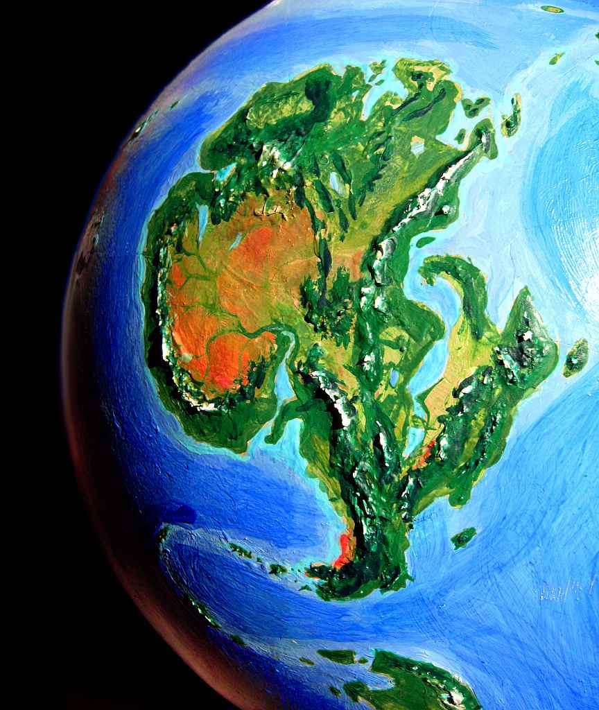
Tropica is mountainous. The long dragon's spine through its east side is the Trans-equatorial Range, with steep jagged peaks rising 4-5000 meters from the Ross Gulf. East of the range, standing alone, the tall peak with a crater is Mt Erebus, a gigantic live volcano looming over a jungle, like some dinosaur-movie backdrop. Southeast Tropica, an ice-smothered gulf in our world, is a low forested plain with narrow sounds and sudden dramatic ranges snaking across it, like a huge New Guinea. In the south, Cape Palmer, larger than England, reaches nearly to Patagonia, in the temperate zone. Our Antarctic researchers dub the (merely chilly) Palmer Peninsula "the Banana Belt" compared to the polar cap; ironically, Cape Palmer is the coolest part of Tropica, and has desert canyons and valleys on its west side, though snowmelt from the mountains keep streams running year-round in the canyons. It looks like Northern Mexico. Still no bananas. Cactus fruit, maybe.
Tropica's southwest coast is a fertile country like Natal in South Africa, rising from the sea to the alpine Princess Range. There are patches of true rainforest, rare on Shiveria, which is too cool and dry to sustain Amazonian-size jungles, even at the equator. Behind the mountains, in their rainshadow, is the Maud Basin, a huge African savanna, broken by many snow-fed streams running down to the Valkyrie River, which cuts a great canyon through the plain from Lake Valkyrie in the west (where the coastal range lowers and breaks up around Amery Bay, letting in enough rain to sustain open forest) to its mouth on Pensacola Sound in the south, a monsoon forest we might find vaguely Australian.
Northwest Tropica is a huge, complex region of lakes and hills. The dark area is the Argus Plateau, a tropical highland 2-3000 meters up, cool to mild year-round, full of unique flowering perennials (we'd likely plant coffee, or tea bushes). The lowlands here are warm and wooded; in our world, soundings show this land is below sea level, but without its ice burden, the land would ride so much higher that the region would be a Congo-size forest. But again, not Congo-wet, except near the coasts. Tropica's great woods are much more open, and break into savanna inland. Still, the image of chimps or even pre-humans picking fruit in the forests around Lake Vostok, where in our world researchers are drilling through kilometers of ancient ice to see if bacteria have survived down in the freezing dark... well, the contrast pleases me no end. And if they learn to make stone spearheads, they can always go hunting on the Maud Plains. Thundering herds of... emus, I suspect. Or mega-roos. I can't see how placental mammals could make it to Tropica--it's way more isolated than our Australia. Sigh! Good-bye chimps, Hello Polynesians. Mere rafts aren't going to get people here!
Heading south, between the Palmer Peninsula and Patagonia sprawls a great horseshoe of temperate island groups, Orkney, Sandwich, Georgia, Shag and Burdwood, before we reach Cape Malvina (our Falkland Islands, now a hilly peninsula firmly attached to the mainland) and the subcontinent of Patagonia, swollen to half the size of Western Europe.
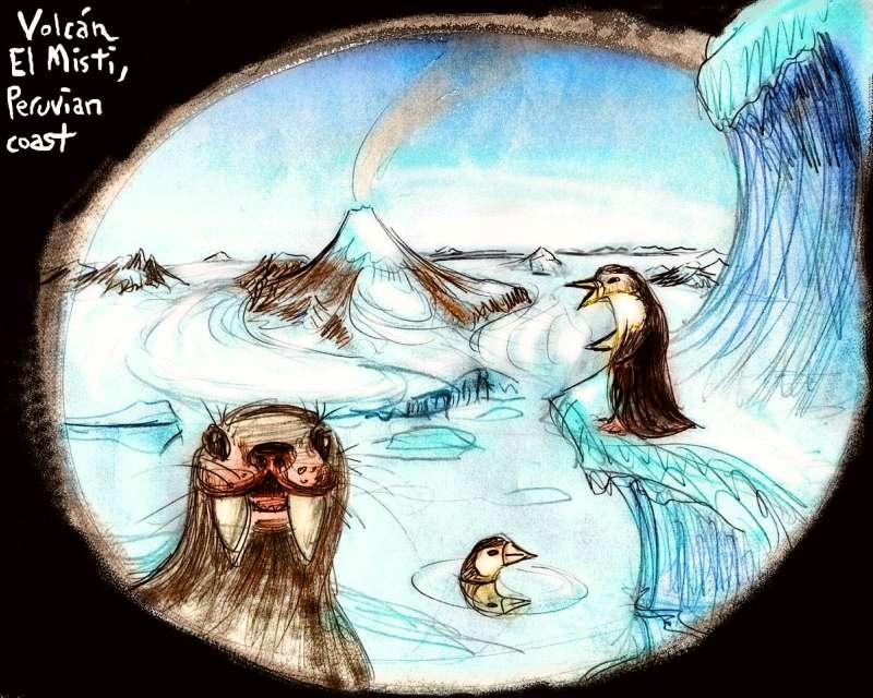
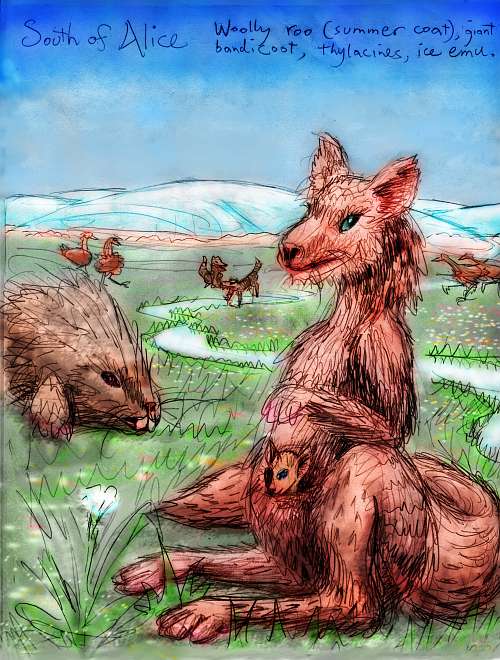
Patagonia's almost as isolated as Tropica. Cape Malvina and Cape Fuego are like northern Japan: cool-temperate, with strong seasons, full of lakes, inlets, and snowcapped volcanoes. Harsh katabatic winds from the glaciers limit the forests to low conifers, and as we head toward the great ice, they hide only in sheltered valleys. Argentina's boggy tundra plains are cold and windy even in summer. Still, the great plain supports herds of giant, shaggy kangaroos, mammoths, and arctic emus. The birds and marsupials have been here since the days of Pangaea; the placental mammals migrated here along the brutal, ice-choked Andean Coast. Caribou would do well here, but they've never made it. Penguins abound on the coasts. Or will, if they can survive the bears. Being ice-walkers and sea-swimmers par excellance, they're one of the few critters that I'm certain can make it here along the Andean Corridor. Instead of arctic foxes or wolves, the smaller grazing animals are hunted by thylacines, these wolflike marsupials also called Tasmanian Tigers, extinct in our world (unless you believe the rumors).
The most interesting creatures are likely to be the mammoths, which, in the warmer north, might swim to the nearest islands, though not Tropica. There's a chance they might be the first land species to develop language and tool use. In our Africa and Asia, apes took over the niche; but here, elephants at last get an opportunity to shine: eons unhunted, in a land of their own. Admittedly, it's not a promising land by ape standards...
A band of meltwater lakes spangles northern Patagonia, between the Andes and the Cordoba Range, and in the Plata Valley. Beyond, all the continent of AMAZONIA, from the Andes to Rio, is one huge icefield, larger than our Antarctica, three miles deep. Our ice cap varies in depth due to the irregular subsurface; this is one huge dome. The total volume of ice is 40% larger than Antarctica.
The Atlantic coast is ice-bound for most of its length, and is impassable. But the slope between the Andes and the sea, though a frigid strip 6000 km long, is not totally ice-bound, nor does sea ice extend far out, due to the strong Galapagos Current not far offshore. Still, glaciers calve into the fjords from Colombia to central Chile. This harsh Andean coast, much like Greenland, is the only land-bridge between Patagonia and the rest of the world. Only truly polar-adapted creatures can pass.
On the other hand, the Pacific coast isn't like Patagonia, whose plains offer no resistance to advancing ice in colder times. The Andes contain the polar icecap; the glaciers on the coastal side are strictly local and don't change size much. So the corridor along the coast, though by no means friendly, is fairly stable. And the Panama land bridge is permanent. Hence my hodgepodge of odd strays from many eras, in Patagonia.
If, of course, Patagonia exists at all. The mammoth kingdom is a land on the edge. In colder eras, the ice may march down the plain to Malvina and Fuego, burying all but a few valleys near the tip, and perhaps a thin strip of maritime valleys on the Chilean side of the long land, like the ice-free fringe of Greenland. Would Tierra del Fuego be a big-enough biological refuge for mammoths? Elephants need a lot of room...
On the other hand, Shiveria's colder climate may be more stable than ours. The ice may never shrink their habitat to the extinction point--just kill off much of their genetic and cultural diversity. Is there a cycle of mammoth civilizations and barbarisms, ninety thousand years long? Unless, of course, some tusked Eric the Red builds a solid enough boat and heads north to stumble on the real Green Land: Tropica.
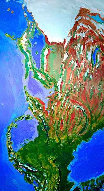
But let's look now at the other side of the great southern ice sheet. The Caribbean is a chill gray sea; its Venezuelan shore is an ice shelf. Huge new islands stud the shrunken seas and gulfs, anchoring the ice. In winter, you could sled from Caracas to New Orleans. The Haitian toboggan team can finally practice locally--if anyone inhabits that swollen but near-dead island. The Antilles and Hispaniola support lichens and scant tundra. The grass grows richer on Cuba and the huge new isle of Bahama, and the greatly enlarged Florida and Yucatan peninsulas. Sparse boreal forest covers some of the Gulf Coast. Great caribou herds and mammoths graze these windy flats, heading north in winter to shelter in the Ozarks and southern Appalachians.
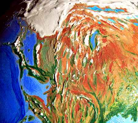
Not North America. Just America. There's really no South left to distinguish it from. Besides, this sprawling southern continent, larger than Africa and largely jungle, resembles Latin America more than our North America.
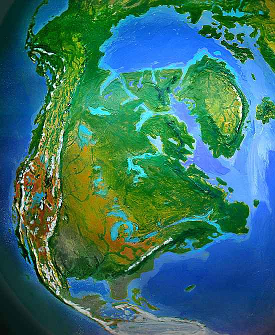
The central Mexican highland supports glaciers, especially on the great volcanoes. Below is tundra and steppe (cold but unfrozen grasslands), with far fewer trees than we might expect. But as Mexico widens toward Sonora and Texas, it warms and supports some woods. The Rocky Mountains and Cascades form a complex ecological patchwork stretching all the way to Alaska, reminiscent of our East Africa. Rainshadows create savanna and desert between these forested ranges. Making the African analogy closer, Lake Bonneville covers half of Utah, and large lakes flood Death Valley, the Black Rock Desert, the Humboldt Sink, Owens Valley, etc. The Gulf of California has shrunken and broken up, and its shores are cool and rainy, with giant trees--one of the few zones wetter than in our world. California's coast is dry, but the mountains are glaciated, the slopes are wooded, and the Central Valley has huge lakes of snowmelt, as does the lower Willamette/Columbia valley in Oregon, and Puget Sound in Washington. From Baja to the Alaskan Panhandle, the coast is temperate to subtropical. West America is a potential cradle of humanoid evolution--assuming suitable primate candidates are present. They might well be, since a tropical strip along Siberia's coast could lead them to Alaska--and there's no Bering Strait to cross. Inland, the savannas would beckon...
For east of the Rockies, the High Plains are savanna--most of Canada looks quite African. Forests, even small patches of rainforest, huddle along the tropical coast near Greenland, with cooler, more open woods in Labrador, Newfoundland, and Grand Banks. Inland the savanna plains are studded by large lakes--not merely the shrunken equivalents of our Great Lakes, but others where our Hudson Bay lies. The savanna dries into treeless steppes in the south, though the Ozarks, the Black Hills, and the Gulf Coast support thin conifer forest.
Southeastern America, the USA's east coast, is harsh. The Grand Banks, now a great cape, deflect the warm Labrador Current far out to sea, leaving New England and points south as frigid and treeless as our northern Canada. The woods thin quickly--the treeline's near Cape Cod. Glaciers cap the ridges of the Appalachians and crawl down the valleys. The Ohio Valley, in the rainshadow of the Appalachians, is drier, a chill desert.
But the northern shores, Newfoundland and Baffin and Ellesmere, are warm and shallow; great coral reefs flourish from Bering to the Grand Banks. Native cultures will be maritime! Greenland, too, is wooded on the coasts, with savanna inland, and ringed in coral reefs. Iceland and Spitsbergen resemble Sri Lanka or Hawaii...in fact, this complex of coastal forests and reefs continues all the way to the Siberian, Norwegian and Irish Coasts. Climatologically and culturally this is one region--not as wet, warm or dense as our Indonesia, but larger--a fertile bridge between hemispheres.
Siberia's south coast is wooded. The warm Greenland Sea, though much smaller than our Arctic Ocean (more like our Caribbean), does generate enough rain to sustain forests. The equatorial Bering Gulf has coral reefs. Alaska's a jungle on the coasts, and savanna between the Brooks and Alaska ranges. The great plain of Beringia just to the north, linking Asia and America, is Shiveria's greatest unbroken forest.
But inland the woods thin quickly to savanna, scrub and steppes, and even these soon break up into a vastly expanded Gobi Desert. The Siberian mountains are tundra and ice. Even in sheltered valleys, only scattered conifers grow. It's a windy, dusty, chilly place, even though it's not that far north.
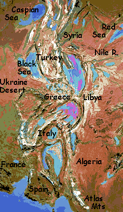
Europe is now the at the heart of the Asian-African-American supercontinent. With most of its climate-gentling seas gone, it's an arid, dusty steppe, except the south coast: Norway, Ireland, England and Biscay, broken only by Skaggerak Sound and Lake Devilshole. The Baltic has dried to a chain of lakes and marshes. The Alps are a cool, rainier ecological island, though its forests are still sparse. The highest peaks are glaciated, even here near the equator.
Portugal's coastal valleys sustain open woods, but over the mountains, Spain is mostly scrub and grass. The Strait of Gibraltar is a dry grassy valley. (What's happened to the Mediterranean deserves a whole section. Note I did not say the Mediterranean Sea.)
Africa is still tropical--but Shiverian tropics aren't quite ours.
Morocco is semi-arid below the glaciated Atlas Mountains. But the Azores, Canaries, Madeiras and Cape Verde chains offshore are Mediterranean. All these shores harbor extensive coral reefs. As we head east, the Mauritanian coast gets slowly wetter until the Guinea Highlands, which are heavily wooded; north and east are coastal patches of true rainforest, especially around the Bight of Benin and on the great volcanoes and isles of the enlarged Cameroon chain. Inland, the woods thin quickly to savanna, then slowly to treeless prairies and semidesert. Lake Chad is somewhat larger, but still shallow (and prone to abrupt changes, so ghost forests of drowned trees often line its shores). The three ranges of the interior, the Ahaggar, the Tibesti and the Marra, pull enough moisture from the winds to be green, but to the west, in their rain-shadows, lies a long strip of true desert, even directly on the equator: the Pseudo-Sahara, stretching nearly to the rim of the Mediterranean Basin.
The Congo forest has shrunk to a coastal strip. Shiverian gorillas will live from Guinea to Capetown, but not inland. Africa's heart is a huge savanna dotted with grazing herds--a vast Serengeti. To the east, the land rises; the highlands in Angola and Namibia, near the equator, are patchy open forests where elephants rule. The coast ranges soon rise higher still, unfortunately cutting off sea-winds and rain from the interior; Botswana is a sea of dry grass with trees only along the rivers. The Kalahari and the Orange River valley are fairly green, however, and the plateau has two great lakes: Etosha and Okavango. Cape Agulhas, the eastern tip of Shiveria's great landmass, is a jungle strip, and a wide one: the cape stretches 200 km further into the sea than in our world. Inland and north, the Drakensberg Mts rise 3-4 km, catching equatorial storms on their cliffs, making this coast one of the lushest in the world. With climate zones so low, the peaks are snow-dusted and the plateau behind them is nearly alpine, even here at the equator�too chilly to be very fertile, unlike our Ethiopian uplands.
To the northwest, Mozambique, Malawi and coastal Tanzania are humid by Shiverian standards, sustaining woods and year-round rivers. Inland, the Lake Victoria basin is grassland, and the great lake has shrunk and broken up, though its severed arms are still large. Lake Malawi is little changed, but Tanganyika's forests are gone--just scrub and trees along the rivers, and woods along the rainy ridges. The Rift Valley gets still drier as it cuts deeper into the interior. The mountains are high enough to catch rain, and many of the higher peaks bear ice caps, but they're too cold for lush forests; conifers and cold-tolerant hardwoods cover the slopes only up to 2500 meters. The valleys and plains are brush, grassland, and desert. These uplands are complex, but less fertile than in our world--squeezed harder between cold at the top and drought at the foot.
Offshore, the large islands and atolls of the Comoro chain lead north to a much-enlarged Madagascar. It too is warm subtropical forest in the lowlands, with conifer forests and a few alpine regions along the mountain spine. The north coast has cooler winters but is equally lush. West and north, the huge Seychelle Islands, nearly the size of Japan, curve in a near-circle. Flat and lush, warm in the south, temperate in the north, the arc ends with two great island-mountains rising from the sea, like twin Hawaiis: Mauritius and spectacular Reunion, with its 3200-meter snowy peak looming over coral lagoons. Madagascar and the Seychelles are a biologist's paradise--less for the sheer uniqueness of species (for the chain is far less isolated than in our world) but for diversity and richness in a biologically impoverished world.
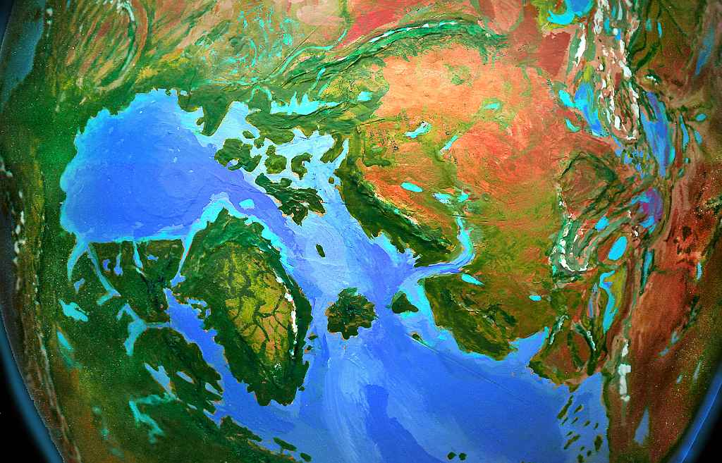
The Red Sea is still ringed by mountains and remains a desert sea, trapped in a rainshadow. But it's a shrunken ghost of itself: the gulfs at its northern end are nearly gone, making Africa, the Sinai, and Arabia one continuous strip. Indeed the sea may have evaporated so much that only a long salt-lake or two remain deep in the Great Rift, far below sea level. It's like the Dead Sea... magnified a hundred times!
In Arabia, the Gulf of Aden and the Yemeni coast are temperate deciduous forests, with pine woods in the mountains, rising to alpine tundra and ice on the 3500-meter peaks. Inland is the vast Arabian Prairie, with warm summers and cold winters, wooded only along the many rivers. The plains teem with horses, elephants, camels and buffalo. The grass stretches 2000 kilometers east to the snowy Zagros Mountains. In the north, around the Gulf of Oman, it's cool and stormy, reminiscent of New England. Adding to the resemblance is the chain of great lakes inland, moderating the climate of Oman itself.
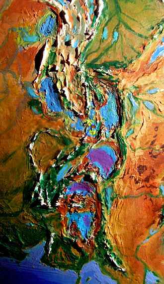
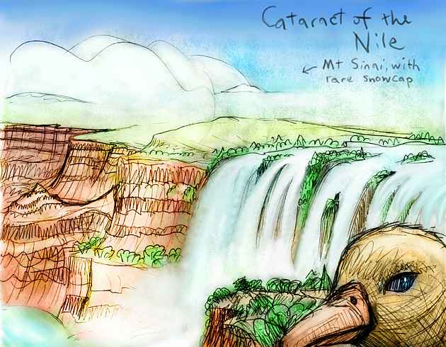
Egypt and the Sahara are warm and dry, but not hot. The Nile has siblings: several more long rivers wind from the Tibesti and Ahaggar mountains down through the dusty plains of this Pseudo-Sahara to the Mediterranean escarpment. Not coast; escarpment. For the Nile and its sisters empty not into a sea, but an abyss, in cataracts, rapids and falls thousands of meters high.
This is the Mediterranean Abyss--the strangest place in the world. Low sea levels permanently cut off the basin from the Atlantic, and the sea slowly evaporated, leaving a gigantic chasm more Martian than anything we know on Earth. At the bottom, 3-4 kilometers below sea level, a chain of warm salt lakes stretches 4000 kilometers, each luridly colored by different algae and halobacteria.
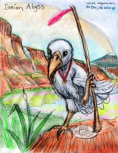
The Abyss is hot, the hottest place on this chilly world. It's generally arid, but many streams rush down the steep slopes from Europe, Africa, and Turkey. The Aegean Lakes lie in a series of basins, from 1-2 miles down; the Adriatic is a modest lake in a long sea-level valley. Corsica, Sardinia, the Balearic Islands, Crete and Sicily are high, forested mountains above deep desert basins. Mt. Etna presides over it all, looming 6500 meters (21,500') above Lake Ionia, usually snowcapped, but sometimes belching lava or sometimes raining ash on the lakes below, causing huge blooms of algae and brine shrimp, which flamingos gather to devour.
This bizarre hothouse sounds forbidding, but the dense air (twice what we breathe at sea level) holds humidity, and being hot, rises, creating local clouds and rain, most of which falls back into the basin. The Abyss is bathed in a soft golden light--the dense air blocks ultraviolet, reducing stress on animals and plants.
Nights are balmy, but daytime temperatures aren't that much hotter than Earth, for the dense air smooths temperature swings. Most important, the high air pressure not only supercharges the lungs, but doubles wing-lift. Flight becomes childishly easy!
Such a Mediterranean Basin existed in our world for a few million years before refilling, but it was a hellish salt-poisoned furnace. But Shiveria's abyss is stable and ancient; over the eons, much of its excess salt dried along lakeshores and was buried under windblown dust or later alluvial fans. Temperatures are hot but bearable--especially since local species have had long ages to adapt fully to this alien world.
 More than that: to take advantage of the air pressure! The largest flying creatures seen since the dinosaurs flourish in the Abyss--and not all of them are birds. Dozens of mammals have become gliders or full fliers.
Still, birds dominate the region--and gigantism rules. Parrots, cockatoos, macaws and White Mediterranean ravens (black feathers were just too hot in these steamy lands), are the most intriguing. Weighing many kilos and with wingspans of 3-4 meters (10-13'), these escapees from the flight-weight restrictions of our world have had millions of years to do what dolphins and apes did: let social competition run rampant, favoring larger and larger brains. Language and tool use follow.
Avian civilizations, some multispecific, some perhaps incorporating flying mammals as well, can be found in every basin of the Abyss; with winged travel, innovations would spread quickly compared to human prehistoric diffusion. Purely because it's an air-pressure oasis, like the Hellas Basin on Mars, the Abyss could well become the cultural and technological hub of the world.
Yet except for the Aegean and Black Sea Abysses, the Red Sea Rift, and perhaps the eastern Caspian, the fliers could not easily spread. For above sea level, megabirds or large flying mammals will find the air exhaustingly thin. Grounded! With their hand-feet pre-empted for walking, unable to handle weapons and tools, birds would be especially vulnerable. Outside the Abyss, intelligent nonflying bipeds have a clear advantage: free hands. Unless, of course, the more sophisticated birds tamed our ancestors and, early on, made them partners or servants--handymen! Division of labor might be along species not gender lines, and be as taken for granted.
In sum: whether Abyssal culture is avian, mammalian or hybrid, it will arise early, yet stay close to home. But even though megabirds themselves can't easily spread, their ideas, tools and reputation will. On Shiveria, even among peoples half the world away from Etna's fiery plume, "bird brain" will be a compliment.
Turkey, Iran and Afghanistan are one unbroken highland, growing colder as you go north. Turkey's mountain slopes support a few forests, but the center is subalpine--mostly grass, rock, and dust. Mountain sheep, or mammoths? From Mount Ararat north, the heights are glaciated; cold, milky streams water conifer woods and sparse alpine meadows. The dry basins in our central Iran are now huge lakes that thaw only in summer. Afghanistan is rugged, cold, and largely ice�the southernmost finger of the Tibetan Cap. West of all these mountains, the Central Asian steppes are vast and bleak. Lying in a rainshadow, this would be desert if it could warm up enough. In many stretches not even grass grows. Here, the dust rules--red storms reminiscent of Mars can blot the sun for days. Only the eastern Caspian, nearly a kilometer below sea level, is warm and humid enough to support extensive groundcover--and possibly megabird colonists, if they're heroic or desperate enough. The western Caspian is marsh land, full of migratory birds--but since it's not far below sea level, Abyssal megabirds or flying mammals are unlikely to live here.
India is a frontier. In cool times, as I've shown it, glaciers cover half the land, and the Bengal Ice Shelf extends far out to sea. The Indus Valley and Thar Steppe are ice-free, but have harsh winters and support only tundra. Still, there's enough precipitation to support rich grasses and caribou herds, which cling to the south coast and Indus Valley even in the coldest eras. In warmer times, the Bengal Shelf breaks up and ice retreats to the Himalayas, Sri Lanka, and the Southern Ghats, exposing tundra on the Deccan and the Ganges Plain. Trees colonize Pakistan, and caribou and mammoths invade India. But the new lands are ringed by ice-peaks, and sooner or later, the glaciers advance again; the arctic spruce retreat to the foothills of Baluchistan, and sheltered valleys on the huge, cool, windy Maldive Archipelago offshore, which deflects (but is thawed by) the warm Madagascar current--a whole string of Irelands in warm eras, or Icelands in cold ones.
Tibet is an ice sheet. It's thin, less than a kilometer deep, because the land's too high; the dry cold air can't carry much snow. But the surface is still as bleak as our Greenland, though great golden nunataks tower over the ice sheet, especially along the Himalayan and Kunlun rims.
To the west, the deep Tarim Basin, also ringed by high ranges, is low enough to build up a true ice cap, miles thick. But it's probably too dry--these Asian ranges, unlike Greenland's, are so high they'd block storms from nearly any direction, so my best guess is that the Tarim basin stays bare and dry. Like the Red Sea, its topography is its destiny. Still, with the Tibetan and Tien Shan glaciers on all sides, ice is possible. After all, this isn't a mere ice age, but a steady state! Snow would have millions of years to pile up.
Yet the depression may be low enough and just warm enough so the glaciers ringing the basin would thaw at their feet, forming a milky, permanent inland sea--freshwater or brackish, I'm not sure. If fresh, it might rival the shrunken Sea of Japan as the largest lake on the planet. I've compromised: the slopes are glaciated pretty far down but the basin floor is cold desert with a central chain of shallow salt lakes, swelling seasonally. But ice-bowl, or freeze-dried desert, or just barely thawed summer puddle, one thing's sure: land life here is sparse at best.
Mongolia is a cold parody of itself. Mountains alternate with dry steppes. But summers are cooler, the rains are gone, the snow rarely melts, and what scattered grasslands survive are tundra. Central Asia is milder than the Dry Valleys of our Antarctica, but that's about all you say for it. It's a land in cold storage, waiting for a spring that never comes.
To the south, Northern Siberia has a warmer climate, though still harsh. Unfortunately it's still in the rainshadow of the highest mountains on Earth, so the endless basins and ranges of Siberia are largely barren. The main refuges for life are along streams in mountain canyons; most creeks are small and end in salt lakes or marshes in the desert valleys below.
The one great oasis is the valley of Lake Baikal: this huge, mile-deep freshwater lake moistens the air and moderates the harsh seasons in its long valley. A linear Oz! For beyond the sheltering mountains, the Siberian Desert stretches a thousand miles all around.
South of this Martian dustbowl, by the Greenland Sea, BERINGIA and ALASKA and the Aleutian Islands form a tropical subcontinent larger than India. It's not as wet or warm a rainforest as our Amazonia, since the small Greenland Sea can't match the Atlantic or tropical Pacific for storms, but it's green and fertile at least--a crucial bridge for land animals between Asia's Pacific Coast, Africa/Europe, and America to the south. Coral grows offshore and in the Bering Gulf; pocket jungles flourish in the valleys of Kodiak, Anchorage and Valdez.
North along the Pacific Coast, the Kamchatka Peninsula ranges from semidesert on the coasts up through oak and pine forests to alpine meadows and icy volcanic peaks. Sheltered by Kamchatka, the Sea of Okhotsk is full of kelp forests and otters; its warm dry shores are quite Californian. The north end, around Hokkaido and the land-bridge of Sakhalin, is temperate, more like Oregon or France, though the forests are thinner and smaller; the higher peaks are ice-clad.
Still further north is the bizarre, landlocked, layered Lake of Japan, by far the biggest and deepest lake in the world. Its depths are brackish, but the top kilometer is fresh water. And this lake/sea rises and falls seasonally. It's ice-dammed each winter, when it swells many meters, then drains each summer through the Korean River at its cold north end, in a strange annual tide. Its shores are like Scandinavia, with mild summers and cold winters. The wide tidal zone is a specialized marsh/grassland with giant reeds in summer, that don't drown but go dormant during the winter flood. We have no real analogy.
Japan up to Fuji, and the Mariana island chain offshore, are Alaskan, with taiga in sheltered spots, bogs and tundra on the plains, and ice in the highlands. North of Fuji is little but tundra to the foot of the Chinese Tongue of the north polar cap. The central ice-cap, over Indochina and Indonesia, is stable, but the Chinese and Indian Tongues advance and retreat; I've shown them near maximum. At full retreat, the warmest that Shiveria ever manages, the wide triangle of ice between Taiwan and Central Asia can melt, leaving tundra. Animals migrate north from the Lake of Japan, graze and multiply and take the vast plain for granted, while forests cover Japan and the Korean shore of the great lake. But around the grass oasis, ice-peaks loom, until, after ten or twenty thousand years, the glaciers reclaim the plain.
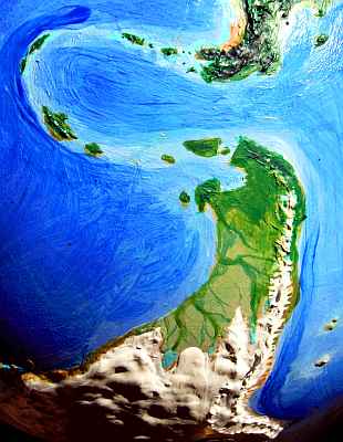
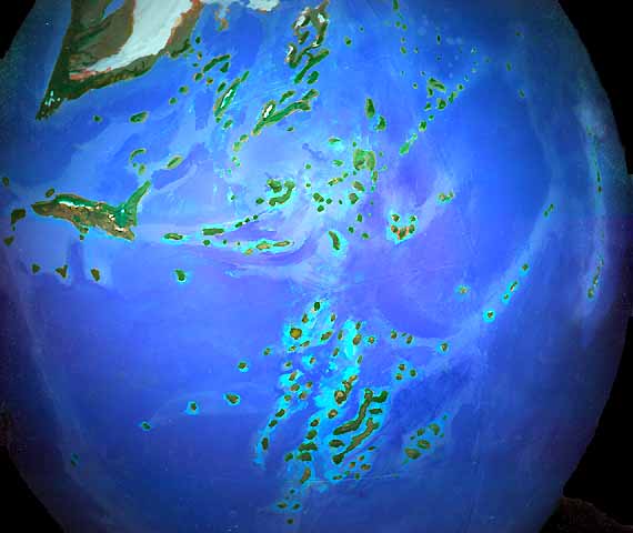
Beyond lies the huge North Polar Cap. The Spratly Islands, a continental shelf bigger than Britain that hides under our China Sea, here supports an ice dome three miles thick. So do the much enlarged Philippines and Taiwan. The sea between them, surrounded by land and ice walls, trapped in place, is not mere sea-ice, but has heaped up as thick as West Antarctica in our world. Indochina is a great ice-bridge between Tibet and this polar cap, spreading fingers deep into China. Indonesia extends the ice-dome all the way to the Outback, with sunken, thinner stretches only where deep water lies underneath, as in parts of the Banda and Celebes Seas. It's a sprawling, irregular ice-mass, ridged and hummocked, sagging here, doming there--much messier than our Antarctic or Greenland, and patchier--but end to end, it extends nearly a third of the way round the world.
The ice frays at last into tundra only on the Papuan coast, which is warmed by the Tasman Current. I may have painted too much coastal ice--the current is strong. The southern lowlands of Trobriand and Cape Siri are tundra, but just across the straits, washed in the hot current, the thousand-kilometer-long Solomon Island has thick chaparral and low trees in sheltered spots, while the equally large Santa Cruz Island beyond, and long thin Caledonia and Chesterfield, all have substantial forests, haunted by huge flightless birds.
On the mainland of what we'll call Outback (Australia means "southern land", and this isn't�but out back, it emphatically is), glaciers cover all the north from Papua to Alice, and down the Great Barrier Range. Despite the inland ice, the southeast coast has fairly mild summers due to its subtropical latitude and the warm currents offshore. A wide belt of tundra and even a few stunted trees stretches from the mountains out to the Barrier Reef and the numerous islands in what we call the Coral Sea (no coral, of course, grows within a thousand miles of it on Shiveria). Herds of huge, ruddy, shaggy roos graze the coastal grasslands and tundra, along with great flightless birds. There are no placental land mammals except mice, for Outback has been quarantined by ocean and ice for at least thirty million years.
The southwest coast supports conifer forests, from Alaskan Perth down to the quite temperate cape of Tasmania, greatly enlarged due to low sea levels. The deep lowland forest where our Bass Strait lies is the richest part of Outback�and a last refuge for many species extinct to the north. As Outback slowly thrusts further into the polar zone, and the glaciers grow, the sea will drop further, possibly opening land bridges as far as Caledonia�but not all the way to Zealand. And such bridges will be tundra, not forest. Much of Outback's biodiversity is doomed in the long run, unless maritime peoples discover Outback and value these species enough to transplant them to warmer zones.
Zealand is nearly continental: it's nearly doubled in area and fused into one strip 2500 kilometers long. Around it swings an arc of islands each larger than Hawaii--some many times its size: the Aucklands and Campbell Island to the southwest, and Antipode, Bounty and Chatham Islands to the south. Both arc and mainland are a patchwork of microclimates--forests, grasslands, and small rainshadow deserts. The mountains are snowy, so river-strips remain green even in summer. With its size, isolation and diverse climate, the Zealand archipelago rivals the Madagascar-Seychelles, Kerguelen (see next section), Cape Tasman and Tropica as lands rich in unique species.
The Pacific Islands are of two types: volcanic isles have grown and risen, often fusing with their neighbors in chains to form long islands like Zealand, Solomon, and Caledonia, hundreds or even thousands of kilometers long. Most are mountainous, forested, cool-temperate lands. The other type, coral atolls built on seamounts, have grown wider, often fused to form long chains or mazes of reefs, but they haven't risen much, for being built of coral, they stabilize around sea level and adapt to fluctuations. But far more atolls dot the Pacific, wherever seamounts reach up near enough to the lowered sea-surface so coral can build.
Tahiti and the Society Islands are this type; both land and lagoon areas are much larger and closer, and rings often have a central island now. Depending on how the coral builds, the topography here is uncertain: either atoll-strips or low but dry land will stretch 1000 kilometers or more, unbroken. But which? Probably something between: a forest/reef maze like our world's Palau, but sprawling over a million square kilometers.
Hawaii has at least tripled in size to become a chain of large islands--from far north of Midway 3000 km down to the twin Big Isles, Greater Maui (stretching to within twenty miles of Oahu) and Hawaii itself. Loihi, the next island, is still growing under the surface off Hawaii's southeast shore. The sea here is 6 kilometers deep; a couple of hundred meters of missing surface water doesn't shorten Loihi's climb to sunlight much. We tend to forget, we surface creatures, just how deep the oceans are.
Penguins still dominate the much enlarged Galapagos Islands (and at least four other large islands off Peru and Chile that are mere dots in our world), but this isn't considered remarkable, since they live all along the frigid Andean coast nearby. Marine iguanas, of course, never evolved here, it's far too cold; an analog does exist on the Chatham Islands, off Zealand, and on the Isle of Kerguelen in the East Atlantic.
The evolutionary biology of Shiveria is obviously quite speculative, but some broad points are clear.
Despite the lowered sea levels and large total land mass of Shiveria, the fertile land area is far less than ours--too much is desert, tundra, and ice. The contrast between icy poles and warm tropics generate strong winds. The land is dusty and rain is sparse. Climates are continental and harsh. Rainforests, Mediterranean zones, temperate and boreal forests exist only in scraps. Biologically, Shiveria's hot spots are mostly game-filled inland savannas, and coastal or island forests.
My guess is that the seas are more fertile, overall--they're constantly being fertilized by dust from the Central Asian deserts. On the other hand, many cut-off gulfs and seas will be more stagnant. Our world's Black and Caspian Seas are ominous lessons.
The world we know has two levels: nearly all the biomass is at sea level, but the icecaps and Tibet and the Altiplano form a second zone, cold, thin-aired and harsh, around 4 km higher. The ocean depths hold little more life than the icy heights. In contrast, Shiveria is a three-story world. Altitude variations are almost Martian in scale--from Chomolungma, over 9000 meters high, to the Mediterranean Abyss, some 4000 deep at its lowest points. The more extensive high level is all ice, and quite dead; the middle layer ranges from familiar to nearly Martian; but the lowest level is a briny, muggy hothouse whose flora and fauna are hard to predict, because we lack a model for it--not just on Earth but anywhere in the solar system.
What of the New World versus the Old? Low sea levels have created one supercontinent and several deeply isolated lands. Before the Shiverian version of Pangaea broke up and the Atlantic Ocean formed, Pangaea was centered in the tropics, with lobes at different latitudes. The lobes would have been biologically quite distinct, even then. So all three island continents, and the extensive Pacific islands, may have developed largely along their own lines since the age of the early mammals, and each bear species as peculiar as our Australia's.
I've already described Outback's odd community of stragglers. Tropica is more isolated, larger, warmer, wetter, and more varied in climate (having much more altitude variation). Further, migrating peoples would need more than mere rafts to find and settle Tropica. The wave of extinctions as Stone Age hunters spread around the world would reach the three isolated continents late or not at all. Even the first Americans took a while to kill off the Ice Age megafauna! So giant crocodiles and Komodo dragons 25 feet long, or half-ton flightless birds, or packs of giant roo-eating marsupial wolf- or bear-analogs--or all of the above--might still dominate Tropica. Or intelligent primates based on lemurs or tarsiers, not apes, might have evolved independently. Or flightless birds might evolve complex social cooperation, large brains, tool use, and language, though I still think the Mediterranean Basin would foster bird intelligence even more, since for the first time in Earth's history, they wouldn't have to sacrifice flight for further brain size.
The land most likely to have been utterly overlooked by predatory sailors or settlers is not Tropica, which is, after all, far too big to miss once boats are invented, but the KERGUELEN ARCHIPELAGO, 1500 kilometers off the coast of Tropica and 2500 from Madagascar. As isolated as Hawaii yet bigger than our Tasmania, it would evolve many bizarre species. If it has large land mammals at all, they'd evolve from marine species--perhaps sea lions or otters. These might develop into fructivorous tree-climbing quasi-primates, wolflike pack animals with brains like chimps (seals and otters are smart animals). Again, social sophistication and big brains might lead to tool use and language. Such island oddities sound unlikely, but consider the tool-using sea otters of California's kelp forests, or the sea-grass-eating marine iguanas on the Galapagos--and Kerguelen is far larger, more fertile, and more isolated.
It's a common fallacy that island ecologies always fall behind to become "fossil" ecosystems, whose species may be fascinating and quaint, but can't really compete on a world stage. One doesn't expect intelligence to evolve among kangaroos. But this generalization is naive. Corvids (ravens, crows, jays etc) rival their cousins the parrots as the most intelligent birds on our planet (and if recent studies are correct, both ravens and parrots rival chimps--one of the reasons I've emphasized avian evolution here as much as mammalian). Yet corvids spread from Australia, only recently as geological time goes--to conquer the world.
To sum up: on Shiveria, with many widely scattered tropical savannas and forests, resembling ancient Africa during the era when we evolved, it's by no means certain that people would arise in Africa first--or in only one place. Indeed, multiple species of language- and tool-users might appear without coming into direct competition until deepsea navigation is mastered. Several branches of the primate family (lemurs, apes etc), elephants, bears and raccoons, otters, and huge flightless corvids and parrots are all possibilities for intelligence--all big-brained land species capable of (or already engaging in) tool use and thus potentially capable of mastering fire. The evolutionary picture is very uncertain.
As it is, of course, in our world, too.
Before boats, early peoples would tend to spread east-west, in a strip from Capetown to Alaska. Interestingly, the dryest, least friendly region (like our Mideast) is still in the middle, around the Mediterranean Abyss; both the Pseudo-Sahara and the dusty steppe-deserts of central Europe would be formidable obstacles.
In our world, the Polynesians sailed halfway round the planet, finding flyspecks in the world's greatest seas with consummate skill. But on Shiveria, with so many islands exposed by the lowered seas, even sailors with less sophisticated boats and navigation could quickly island-hop between Tropica, Patagonia, Zealand, Outback and the huge Pacific chains. Together, these form an oceanic New World; the question is, would seafaring peoples from Madagascar or Beringia first cross the wide deep-sea barriers from Old World to New? Or is my question biased? Perhaps the fertile soil of Tropica would be the cradle of intelligent life and civilization, and the great question would be, will Hawaiian or Kerguelian colonists first discover the vast continents beyond?
Either way, the bars of Casablanca may be full of New World lemurs cutting trade deals with Old World birds... while everyone makes way for the elephants. Apes like us may still be in the trees.
Our prehistory had a clear crossroads in the Mideast, where migrations to and from Asia, Africa, and Europe all passed, spreading ideas, seeds, and genes. Shiverian migration patterns are more uncertain. Beringia and the Mediterranean Abyss are both obvious land-crossroads, but the retreat of the rains to the coasts and islands will foster sea-cultures and sea-migrations, not land-routes.
Dry regions with reliable rivers are nurseries of agriculture. We tend to forget that the tight clustering of our ancient world's great irrigable flood plains in the Near East is a geographical accident. Where conditions are right, agriculture independently developed, whether in China, Mexico, or the Andean streams flowing through coastal deserts. In Shiveria, Nile-like floodplains begging to be irrigated aren't clustered in a Near East, but scattered: the Valkyrie River in northern Tropica, the rivers in central America, the coast from Malawi to Somalia, the huge Arabian Prairie, the Nile and its sister rivers across the Pseudo-Sahara, and the Lena and Ob in south Siberia. There is no cluster where agriculture, irrigation, and city-states would inevitably evolve first. Indeed, given the relative biological richness of islands here, the center of gravity of early Shiverian civilization might not be centralized "hydraulic" empires at all, but wide networks of trading and fishing villages, with no obvious center. This might flatten the sharp technological and military gradients that allowed empires and colonialism to become so extreme in our world. Shiveria, with its web of island cultures, would not easily allow a single continent to dominate long. This is all curiously parallel to Seapole, a hothouse Earth I've previously described; despite their contrasting climates, both worlds are more likely to develop maritime cultures than ours. It looks like higher OR lower seas create more islands! The way great continental floodplains and grasslands dominated our early history may be a historical accident--due to an ephemeral island-shortage caused by our particular, temporary sea level (if we don't raise it, the next Ice Age will lower it again).
Shiveria is harsh, with a biomass way below ours. It's much like the Siberian ecology that inspired Kropotkin's famous argument that the struggle for survival is often against the environment, not the neighbors�-so cooperation's often more "fit" than Darwinian tooth-and-claw competition. Due to Shiveria's dry, hardscrabble nature, I suspect our problems of war, plague, empire and racism would be largely replaced by poverty, drought and hunger. Famine will be the great population-limiter here.
It's curious that on Shiveria, the Mediterranean remains a center from which cultural innovation radiates--though in different directions, and for a wildly different reason.
But like Hudson Bay, these cities could evaporate at a word. Would there even be a Mediterranean Abyss, or would the river inflows be enough to let the sea survive (and would it eventually end up freshwater, as it drained out the Gibraltar River)? What if my meteorology's off, and more forests survive than I predict? Then all the savannas and Mediterranean zones shift--and cities and civilizations shift with them. Or what if it turns out all ice ages really are inherently ustable, containing the seeds of their own destruction, and my sterile scenario forces CO2 to rise, drowning the whole dusty mess?
I hope so. Shiveria is grim. I hope it warms, and floods. A greenhouse world would be heaven after this. Let it drown!
Only... I'll miss those bird-people in the Abyss. No one ever wheeling through the sweet air above the Nile Falls?
As a kid, I looked at the continental shelves on National Geographic maps with a certain envy, thinking of the Ice Ages, when vast new lands were exposed, and you could walk from Bali to Ireland to the Falklands. I built Shiveria partly to embody that dream. But cold winds don't carry rain well. They do a fine job spreading dust, though! Mere square mileage doesn't count for much, if it's all desert. Cold, dust storms, huge canyons and empty seas, fierce winds, channeled scablands, and ice...familiar, isn't it?
I've seen Mars on Earth, and it isn't pretty.
So, LESSON ONE: Ice is bad. Sounds banal, but it has awkward political implications. As an American leftist, I hate my government's casual dismissal of global warming, my people's reckless burning of oil... yet after building models of both a cooled and heated Earth, it's clear that warming is less catastrophic than cooling would be. Humans are coastal, so we'll suffer from global flooding, but life as a whole will not only adapt readily to a warmer world, it will flourish--for our present climate is colder than optimum. Or, to be more accurate, drier.
For LESSON TWO of Shiveria is that warm = wet and cold = dry. Early in paleoclimatology, this was masked by the fact that many paleontologists worked in the Mediterranean and the American West, two of the few places in the world that got wetter in the Ice Age. I grew up with a cold-and-rainy model that turned out to be simply false. After studying current knowledge of Ice Age conditions worldwide, I'm convinced global warming consistently increases rain. Steambath Earth, not Desert Earth.
LESSON THREE: to my surprise, Shiveria's an equally dismal world by nearly all scales--biomass, diversity, habitability, usable land area... with one exception. Only in sapiogenesis (the creation of intelligent species) does it show unusual potential, and only because of that weird Mediterranean hothouse--and with its heat and dense atmosphere, it's so alien to the rest of Shiveria it might as well BE another world. Again, warm is good, cold is bad.
So go ahead, drive your big new car, drown your cities! Hey, it's good for Gaia.
I wrote those words with a mocking tinge. But now, looking at my globe of sad, dusty Shiveria, I wonder if perhaps I meant it--and we're Gaia's mechanism for permanently ending the Ice Age--all unaware that our present disruption is part, admittedly a drastic part, of a greater homeostasis. Because, with our blindness to history, we've forgotten how drastic the Ice Ages have already been. Our beloved Earth was just as cold, dusty, rusty, dried and frayed as Shiveria, just eighteen thousand years ago--and it may soon be again.
The eco-crash has already happened.
And we grew up in the ruins, as they began to heal--and called the ruins home.
Well. Having gotten all emotional, having said all that... let me undermine it.
Contemplate this banal proverb for a moment: "The grass always looks greener over your neighbor's fence." Think it's about envy? Wrong. It's subtler than that. You see, it's literally true. When you look at grass you stand on, you're looking down. You see the leaves end-on--and you see quite a lot of bare earth. When you look over the fence at your neighbor's grass, you see the leaves full-length and the dirt at a low angle. The green blades overlap and hide the ground.
Even if your grass is identical, your neighbor's really does look greener. Always! It's not your envy--it's your viewpoint.
And this effect crops up in other places. Ever notice, on a busy, multi-lane road, how you always get stuck in the slowest lane? Lady Luck isn't out to get you--by definition the most crowded lane will have the most people in it! Clear, fast-moving lanes have fewer drivers. More often than not, you really ARE in the worst lane! The other lanes ARE "greener"--till you move over, and slow them up!
Now, the opposite principle applies to alternate earths. Let's contemplate Randomia, an alternate Earth no better or worse than ours, with roughly the same biomass, same amount of arable land, about the same population... just re-distributed. Now, what regions will you notice the most? First, your home, of course, and then, other well-known regions--and well-known means inhabited.
So what's the subjective effect of that? Randomia will always look inferior!
For, by definition, most readers will be from our world's high-population zones. Random changes will, on average, degrade them. And the lands that improve, that become the heartlands of Randomia's civilizations, are likely to be barren obscure lands in our world, mere names (if that) to non-Randomian readers. The Shiverian version of Europe is a dreary waste (half a billion European readers frown), while green Antarctica nurtures great civilizations (two thousand scientists cheer). If you love civilization, Randomia will probably kill or cripple the ones you love, and plant its greatest civilizations in places you associate with backwardness.
So the grass always looks browner in a parallel world--because what you value most, what you KNOW to value, is generally lost. This principle makes it hard to see alternate worlds fairly.
So, if I seem foolishly optimistic about these alternate Earths, postulating island leagues and tropical civilizations and intelligent lemurs or elephants or mega-ravens... just remember I'm fighting the Randomian factor. Your view is colored by the degradation of what you know and love; so my predictions of new growth and life in the unlikeliest regions, will seem fatuous. Yet they grow from the same data as the doom and gloom--your perceptions are naturally tilted toward seeing the losses. Factor Randomia in, before you mock.
I mean, I don't like Shiveria. Oh, it's beautiful from orbit, with all those lovely red deserts and golden savannas to set off the greens and blues... but who'd want to live in the cold and dust and drought? But the Shiveria I inevitably see, the dusty Martian graveyard of China, India, Europe, Indonesia, Brazil, Australia... that's not how Shiverians see their home! A vibrant world with two wildly different ecologies and a multi-species civilization, with four rich heartlands in Tropica, Canada, Africa and the Abyss, a world with fertile islands over every horizon! A good world. Home.
The Shiverians, looking at us, would see their heartlands drowned, frozen, dried--and, worse, all intelligent species extinct but one! Culture itself dwindled to a monopoly, in the unreliable hands of a single species--a violent, uncooperative ape.
No Shiverian would want to swap.
Over the fence, our grass would look pretty bad.
World Dream Bank homepage - Art gallery - New stuff - Introductory sampler, best dreams, best art - On dreamwork - Books
Indexes: Subject - Author - Date - Names - Places - Art media/styles
Titles: A - B - C - D - E - F - G - H - IJ - KL - M - NO - PQ - R - Sa-Sk - Sl-Sz - T - UV - WXYZ
Email: wdreamb@yahoo.com - Catalog of art, books, CDs - Behind the Curtain: FAQs, bio, site map - Kindred sites