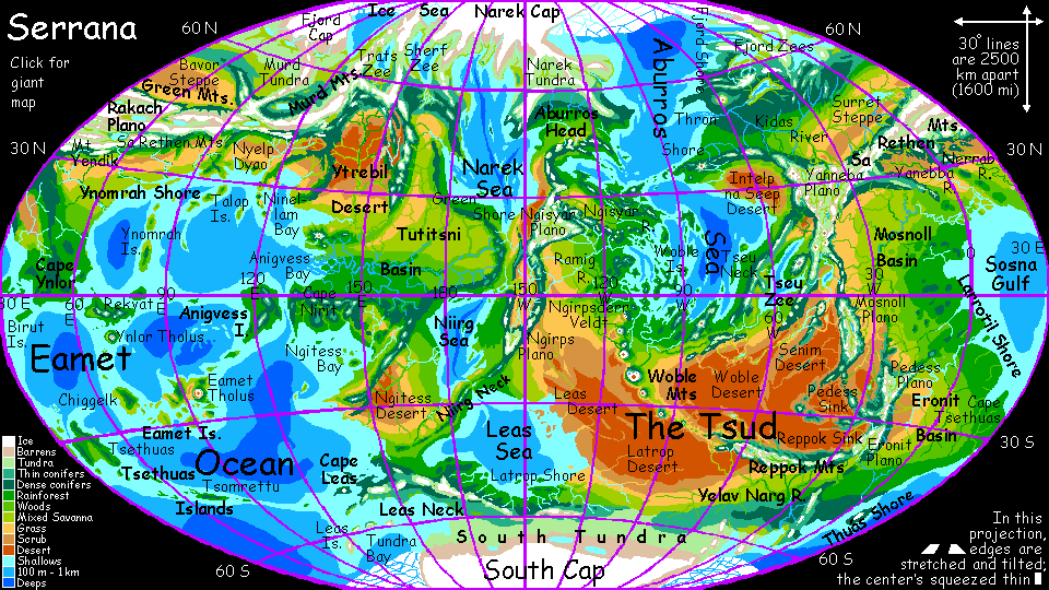
In the Eamet Ocean
by Chris Wayan, 2004
Serrana - map and regional tours - Creatures and People - Culture - Evolution - Gazetteer - How I Built Serrana -
More worlds? Planetocopia!
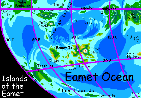
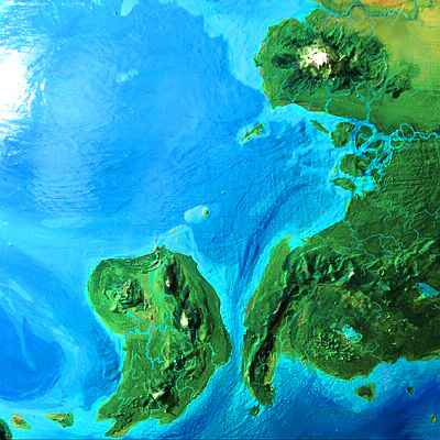
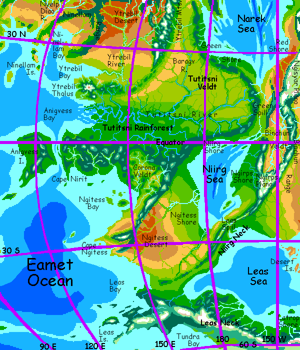
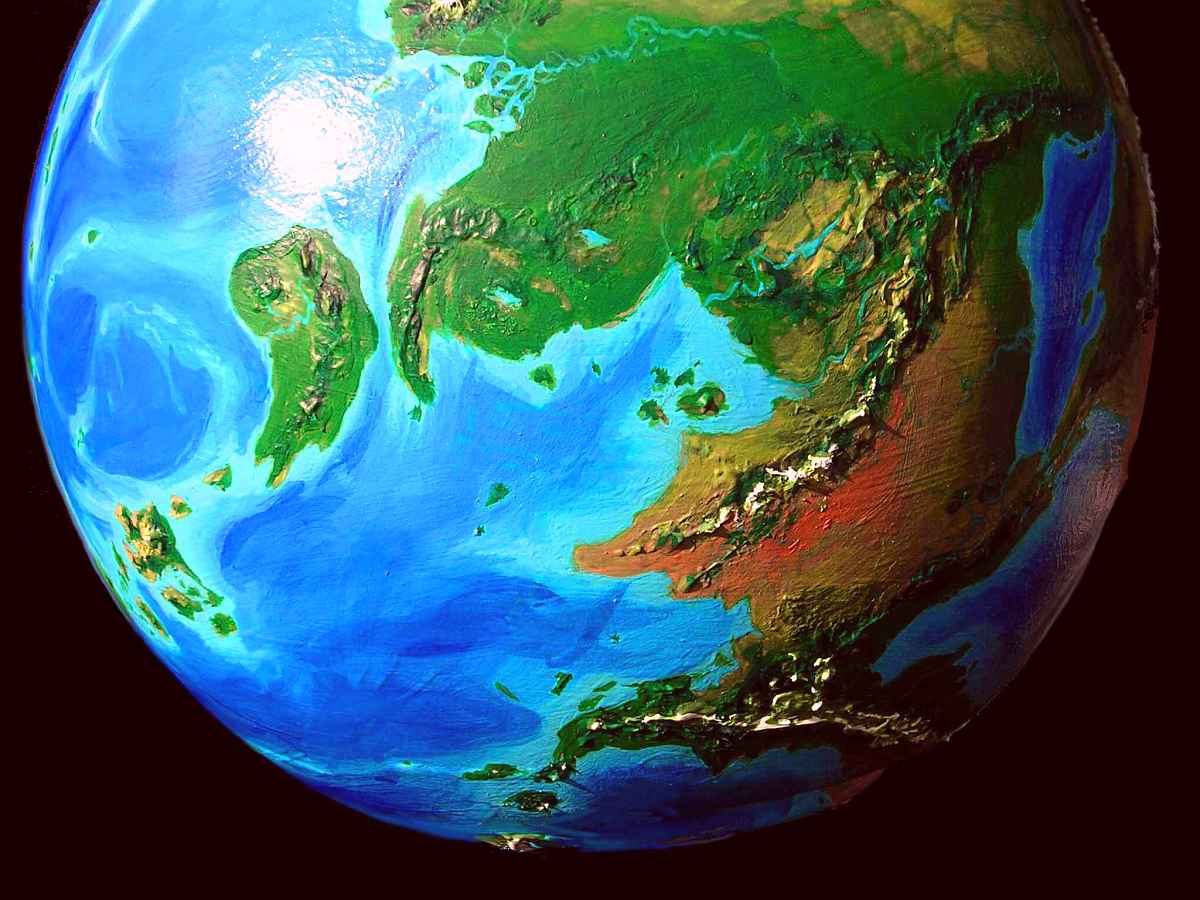
60% of Serrana's water by area, and two-thirds by volume, lies in the Eamet Ocean (eh-AH-met, nearly YAH-met). Even so, the Eamet's much shallower than any Earth sea, and full of island arcs: the Tsethuas Islands in the west, the northern Birut, Ynomrah, Talap, and Ninellam Islands, the central Eamets, the southeastern Leas Is., and huge Anigvess in the east.
We'll start our tour in the ocean's heart--the Eamet Archipelago. It's much the size and climate of the Philippines, though with a drier climate more like Hawaii: wet on the upwind side, but savannas and even desert canyons on the northeastern, downwind slopes of its many mountains.
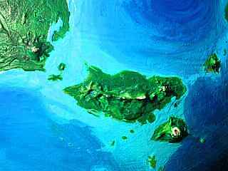
Eamet proper, by far the largest, is a snaky mass of lava flows 1000 km wide, built up by Eamet Shield, a massive volcanic cone 7 km high. A peak rising 23,000' from the middle of the largest ocean in the world sounds unlikely, but remember how shallow Serrana's seas are--half the Hawaiian Islands are taller, base to top, than Eamet Shield.
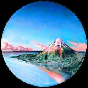
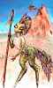
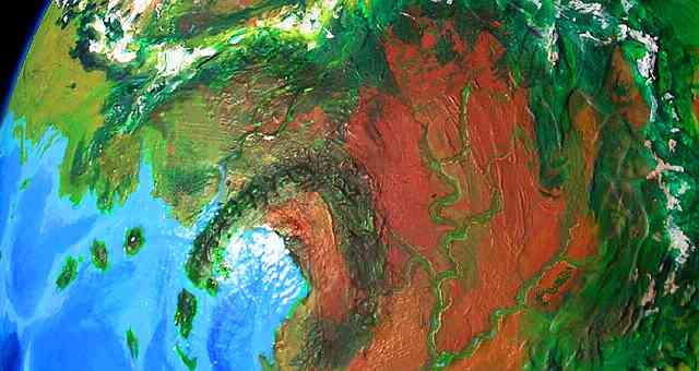
And the Eamet Basin is rather flat--more like Mars's North Sea than our rugged Pacific basin. The only other major volcanic field, with peaks high enough to glaciate, is the equatorial Ynlor group 2500 km northwest. Pictured: a satellite volcano west of Rekvat, a mere three miles high. Notice how much steeper these peaks are than Earth's shield volcanoes! They're fighting much lower gravity.
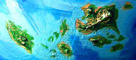
Chiggelk, the next largest of the Eamets, at the west end, has only modest mountains clad in evergreen woods, rarely seeing winter snow. Still, Chiggelk's nearly as big as Ireland--600 km long, 300 wide. Eddat and Ramma are less than half as big, with low, warm Mediterranean hills. Hundreds of lesser isles surround the big four.
The Eamets are about the most isolated land on Serrana--boats and rafts must follow a 1200-km (750 mi) chain west from Anigvess, with open-water gaps up to 320 km (200 mi). On Terra a similar gap was rafted across to reach Australia fully 40,000 years ago, in the Stone Age;
 but I doubt the Eamets were reached so early, for the people living on rainforested Anigvess were mostly tree-squid--comfortable in the water, but for that very reason not boatbuilders, and, more importantly, a stay-at-home people, with (especially in ancient times) a tendency toward going it alone, like humans--or better, like cats, as treesquid evolved from solitary hunters and are still just partly socialized. When they did, eventually, make it out as far as Eamet, they weren't impressed--being further south, it's much cooler and drier than their rainforested homes. They dismissed the archipelago as worthless and told no other species about it for centuries.
In the end, casual mention of this "worthless" land to outsiders sent explorers of three species more suitable for Eamet's open woods and fields--hexapi, taurlopes and raptors, who still dominate the islands today, though Planian towns now ring the highlands of Eamet Shield. Even some squid have finally settled the rainy side of a few islands.
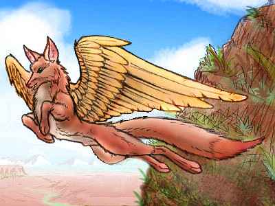
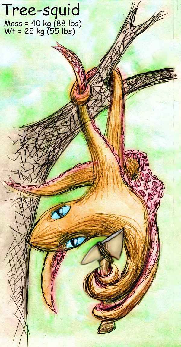
Explorers found a land full of bizarre creatures. The largest were wingless birds and gryphons, who, in the absence of large predators, grew too big to fly. Some now resemble ostriches, emus, small deer, dawn horses (with paws; distant relatives of taurlopes), and feathered kangaroos. With all these bipeds and quadrupeds, the Eamet Archipelago is the most Earthlike place on Serrana! The top predators, interestingly, were packs of flying foxes, evidently fairly recent immigrants flourishing among such easy prey, and grown larger and more intelligent than any mainland breed--possibly on the way to becoming mere gliders or land-bound pack hunters like Terran wolves, though by removing the flight-weight constraints on their brain size, it might also have made them people. Would you give up wings for brains?
These big-headed, big-brained Eametian flying foxes, clever but quite trusting (since they themselves lacked predators) are the ancestors of the domestic foxes common in Serrana's villages today. Valued both as messengers and for their increasing language comprehension, they're under selection pressure that may make them people yet--and keep their wings, too. Only deep time will tell if that's aerodynamically possible.
THE EASTERN SHORE
Sailing east from the Eamets, we reach comma-shaped, equatorial Anigvess Island, bigger than Madagascar. Rainforest covers all but its highest peaks. The ground level is damp and gloomy, but the canopy teems with life: lurid flocks of flowerlike birds and griffins. The Nirit Peninsula, just a few km over a narrow strait, is another million square km of hilly jungle. Anigvess Bay, to the north, right on the equator, is as close to Amazonian as this planet gets. It's all tree-squid country; their wicker villages high in the canopy web the jungle, which they carefully tend, harvesting nut and fruit crops exported all over this hemisphere. Think that's absurd, squid up a tree? Don't laugh--they ink you if you laugh.
The great rainforest's broken only by the swampy bayous of the huge Ytrebil Delta and the cloud forests, alpine meadows and glaciers of Ytrebil Tholus, six km high; the only large volcano on the Eamet Rim. With so many climates in close proximity, the mountain's multiracial--its towns have long been hotbeds of cultural innovation, competing technologically and artistically, something like ancient Greece or Renaissance city-states. The Tholian hill-towns are a magnet for bright, noncomformist, and just plain misfit cubs, all over the region.
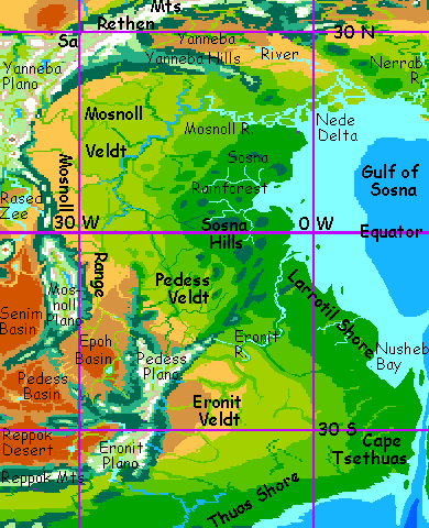
North of the great peak, around Ytrebil Bay, the rainforest thins to savanna. Inland, up the Ytrebil River, even the grass thins to the Ytrebil Desert, largest in the northern hemisphere. Rains from the Narek Sea are cut off by the Ytrebil Range; from the north, by spurs of the Murd and Trats Ranges; from the east, by the Ninellam Hills; and from Ytrebil Bay by a high-pressure zone hovering around thirty north. But the high ranges forming the basin do feed snowmelt into the many-branched Ytrebil River, and its upper valleys form as fertile an oasis as the Nile.
In prehistoric times, only raptor tribes survived in the desert, raiding hexapi farmers on the river; eventually a biracial civilization arose, with an almost feudal class structure--a raptor military caste and a hexapi civil-engineer caste over a mostly hexapi peasantry. They built step-pyramids reminiscent of the Maya or Babylon--though we mustn't get carried away by the parallels; they were round! Still, Ytrebil was the nearest thing to Terran hierarchy and empire and racism and slavery that Serrana's ever known.
But the contrast with freer societies around it, especially the multispecies cities of Ytrebil Tholus, fueled perpetual resentment and social unrest. Taurlope farmers in the eastern and western foothills naturally supported their hexapi neighbors, helping to smuggle out fleeing serfs, boycotting abusive clans, and simply by showing showing no respect for the religious hierarchy. In the end, this proto-feudalism collapsed, and Ytrebil returned to a more normal Serranian pattern of rough equality. There wasn't even a revolution; houses that granted serfs more rights steadily outperformed conservative ones. These had to compete in a sort of political wage spiral--or watch their serfs passively sabotage business, and (if their clan masters cracked down) head down the river.
It's suggestive that the most relevant Terran model is so late in our history. The leaders of the American revolution thought separation of powers would protect against tyranny and maintain dynamic stability, and three power bases was the minimum number they deemed stable, too.
Is there a broad principle here? The history of Ytrebil suggests that
THE NORTHERN SHORE
Let's return to the coast. North of the Ytrebil Delta is Ninellam Bay, 800 km long and 400 wide, a miniature Mediterranean sheltered on the west by long Cape Ninellam which trails off into an island arc. Inland lies Ninellam Basin, a semi-arid plain below an arc named... oh, you guessed. The Ninellam Hills are only 2 km high, but their piny heights sharply divide the rather Californian coast from the hot Ytrebil Desert inland. Ninellam's not scenic, but has a pleasant climate; taurlope farmers and raptor roo-herders predominate.
West of Cape Ninellam lies a similar basin called Nyelp Dyao. The coast is Mediterranean; inland is a hot dusty plain below the huge Sa Rethen Mts. It sounds like North India, but there's no summer monsoon; the mild winter rains are all it gets. Nyelp Dyao is pronounced just the way it's spelled (OK, OK, it's just "Wide Plain" backward; that's the name of this region in "The Dispossessed").
This coast is getting monotonous! Next is a THIRD cape-and-bay: Cape Rapip, ending in an archipelago much like the Ninellams: the Talap Islands. The Talaps and Cape Rapip are Californian on the coasts, but inland the rains grow sparse: dreary scrub. It's perfectly livable country (at least if you're a heat- and drought-tolerant raptor or taurlope) but not, by any species' standards, beautiful, except in the short spring, when wildflowers suddenly paint the brown land luminous with pure hues and the locals all dance and howl for a week.
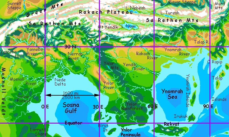
To the west is Ynlor Peninsula. In Ursula Le Guin's The Dispossessed, Rolny was a dreary, barren sand-spit. But this was a climatological error on her part. Location is destiny: Rolny was right on the equator and sea-girdled. Even on chilly Anarres, it's unavoidable: Rolny would be an equatorial rainforest! Maybe colder and less rainy than ours, but inevitably wetter, greener, more fertile.
And all that goes double for my revisionist Ynlor Peninsula. Ynlor resembles south India in size, shape, and climate, except it's further south and thus even rainier. The central hills and southern tip are lush year-round; but even the driest parts, the Ynlor Basin in the northwest and Yendik Basin in the northeast, are monsoon grassland, not desert.
The Birut Islands, southwest of the cape, are low and rainforested, girdled by wide coral reefs; the largest is 200 km long.
In the jungles of Ynlor you'll sleep high in the canopy, in tree-squid villages. Don't worry; though I've described them as incompletely socialized, these are friendly people--unless you're a raving extrovert who can't stand to be alone. Treat them like big smart squelchy cats, and you'll get along just fine. Just don't disturb a squid hanging alone on a high branch. You'll get inked. If you're dumb enough to ignore my warning, at least heed this one: don't waste your time trying to wash it off, either. That stain lasts for weeks. Everyone's going to know.
The Biruts aren't the only islands offshore, just the nearest. To the southeast, the Ynomrah Islands extend a loop from Ynlor all the way back north to the Texan shores of Ynomrah. Rekvat, the largest island, is a strip of rainforest rivaling Sumatra, with a similar spine of volcanoes. The lesser northern isles, like Irukuk or Ynomrah itself, are still as big as Bali or Flores, if not Java. They're drier, though, and less fertile.
To the south is Ynlor Shield, a volcano 6500 m (21,600') high, forming an island the size of Taiwan. It's a bullseye of climate zones, from steamy rainforest through cool cloudforests to alpine meadows to high-altitude desert and glaciers.
Ynlor Shield's many niches attract misfits, idealists and weirdos; diverse communities on its slopes play out social experiments, both short-lived and long. Though Ynlor's reachable only by boat, and was therefore settled late and slowly, the island has a rising reputation as a rival to the multicultural delights of Ytrebil Tholus, 5000 km to the east.
THE WESTERN SHORE
West of Ynlor is the vast Sosna Gulf, nearly a sea of its own--10 million sq km (4 mil sq mi). All the shores of Sosna Gulf are fertile, though the north end is Mediterranean, less lush than Ynlor or the southwestern Larrotil coast. But even at the northern tip, water dominates: the Nede Delta (rhymes with "mayday") is a lush brackish swamp with winding tree-lined channels, something like the Everglades but bigger than the entire state of Florida, between the mouths of the Yanneba and Mosnoll Rivers. Squid heaven!
West of the gulf lies the Sosna Jungle, an equatorial rainforest covering the low Sosna Hills, full of woven treetop squid villas. South of the line is the long Larrotil Shore, a green subtropical strip rather like coastal Brazil, with short rivers rising to low hills; inland is another world entirely, Eronit Prairie--the taurlope heartland.

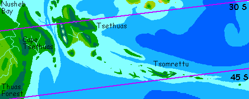
Larrotil stretches fully 3000 km to Nusheb Bay. Beyond is Cape Tsethuas, a blunt wedge of rich broadleaf woods, broken only by a few meadows, dividing Sosna Gulf from the Eamet Ocean. It's rainy, with muggy summers and cool but mostly frost-free winters, like Carolina or southern Japan.
Offshore is Tsethuas, the largest island in the world, bigger than Borneo. Like the Cape it's a vast broadleaf wood, broken mostly by snowy volcanoes in the southwest--the strait making it an island seems to be a rift valley, and hotsprings and volcanoes abound.
Tsethuas is pronounced rather like "Teeth was" and really should be spelled Tsiithwass or Tsythwass, but I was hasty in transliterating and now we're stuck... like poor old Yucatan (which means "What'd you say?") Notice the shape of the peninsula conflicts from map to map, too. We're at the edge of my satellite photos, so I'm relying partly on local maps and narratives. The world map discreetly places this region at the edge too, hiding my relative ignorance, but in this tour we're too close for obfuscation. I'm certain that the island, like the cape, is huge, wooded, temperate, and not nearly as densely settled as such a land would be on Earth; but beyond this, most is hearsay.
Out past the huge main island, the windy Tsethuas Chain crosses the ocean all the way to Cape Leas--narrow, lonely isles scarcely bigger than Crete or Sicily (well, except Tsomrettu, a good 500 km long). Along the more sheltered northern shore, you'll find fishing villages of featherballs, the cool-weather subspecies of raptor, the ones who look like feather dusters. But that's all--the isles are too cold for squid or taurlopes, and the dense woods make Planians claustrophobic. Culturally, they're parochial and backward--like any monoculture! Like Earth.
The Isles are the very opposite of warm, crowded Mosnoll and Eronit. And the islanders know it. Tsomrettu translates as something like "Furthest" or "Loneliest." I'd rather go back and dance and make a general fool of myself at the Mosnoll Solstice Fair, and so would most Serranians--of any species.
THE SOUTHERN SHORE
South of the misnamed cape is the Thuas Shore, the cool green southwest coast of the Eamet Ocean. Winters can be snowy here; Thuas is seasonal hardwood forest like New England. It's an undramatic land--no great Martian peaks, no desert canyons, no weird planos--just a quiet forest as big as the eastern US... and much like that land was, in precolumbian days. Like the Tsethuas Islands, its inhabitants are mostly featherballs. These dense woods are just too claustrophobic for other people--except squid, and they hate snow. Populations aren't dense; it doesn't occur to featherballs to clear large fields and farm; that's not their style.
Past Thuas Island, the coast turns misty and dark: dense "pine" and "spruce" forests run far inland, along the Yelav Narg River. Villages are scattered here; food is scarce. Past sixty degrees south, the forests gradually dwarf and thin to tundra, only visited by nomadic mammoths from the west.
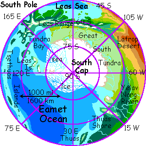
A naive observer might mistake Serrana's south polar cap for Antarctica, but there's a profound difference. Serrana's south pole is only half land; the Eamet half of the great white patch is just thin sea ice, to within 200 km of the pole. The strong Thuas Current flows along the shore, melting the ice in summer past 75 south; even in winter the sea freezes no further north than 60. The current slowly cools as it runs east along (and under) the ice; the east end of the shelf, in Tundra Bay, south of Cape Leas, reaches much further north. Tundra Bay is over 2000 km long and 1500 wide; inland, the largest wedge of tundra in the world stretches all the way round to the Eamet's other shore again near the Yelav Narg--halfway round what would be the Antarctic Circle, if Serrana had one. With little axial tilt, the sun stays low year-round--in summer, it just swells in apparent size--and warmth! Serrana's eccentric orbit does create seasons at the poles, but they're less extreme than Earth's. No midnight sun, no sunless winters.
South Tundra and the steppes to the north, nearly 3 million square miles (7M sq km), are all mammoth country. Lichen-eating nomads in ancient times, mammoths have changed the least of all peoples of Serrana. They're so big, and can strip these fragile, slow-growing fields so quickly, they have to keep moving. Technology, culture, dental hygiene, yes. Villages, no. Giant grass- and lichen-eaters can't afford to settle down. (If for no other reason, imagine the smell...)

So mammoths wander in small tribes. They resemble, more than anything, the Siberian tribes who hunted Earth's mammoths to extinction. Ironic? The environment limits the possible survival strategies, and that shapes culture just as much as your body-shape! So mammoths have tools and fire, but travel light, in small nomadic bands. Their culture's in their heads--in their tales and songs.
Mammoth tribes are anarchistic, rejecting political or religious hierarchy or traditions. Shamanism, not religion. Each individual must build up an inner spiritual language and cycle of visionary tales, which can be told to others by the owner, but with a divine copyright, not to be passed further on without attribution--on pain of nightmares from the story-gods. Divine wrath is needed, for to mammoths, good tales are as powerful a status symbol as strength is for moose, beauty for peacocks, or money for humans. As the mammoths themselves tell it, they breed for wisdom.
Of course, like any ideal, this can in practice mean merely glibness and showmanship. Still, mammoths are undeniably brilliant speakers, actors, singers. Unlike lions, peacocks or humans, sexual dimorphism is low and competition not a male specialty; both sexes need to impress potential mates with their insight, so there's real substance to the claim that mammoths have the keenest social and psychological perception of any Serranian species. At the least, their standards are high; as in classical Japanese culture, shallowness or insensitivity are mammoth sins.
Or at least dullness is.
FULL CIRCLE: BACK NORTH
North of the tundra is Leas Neck, a cool strip of pseudo-cedar and pine below snowy peaks dividing the Eamet from the Leas Sea beyond. A mid-sized southern sea, about 2 million square miles (5M sq km), Leas is the shallow, salty dregs of a sea twice its size that covered the Latrop and Leas Deserts in warmer, wetter times (petrified forests can still be seen inland). Leas Neck's piny mountains stab due west into the ocean, creating a long cape and an island arc curving back south nearly to the great ice shelf. The Leas Islands sequester the waters of Tundra Bay, keeping them frigid--but also sheltering the warmer sea to the north, in Leas Bay. The only inhabitants are featherballs in the dense lowland woods and scattered, recent villages of Planians in the mountains.
But this is all inland; to close our circle round the Eamet Ocean, let's return to its coast. Just north of Cape Ngitess is, naturally on this name-short planet, Ngitess Bay, some 1500 km wide. Its south shore is Californian. The north is hot and rainier, ranging from open monsoon forest to true rainforest on the cape. Villages here are often mixed-species--raptors, taurlopes and hexapi, with fewer lopes and raptors but more squid in the trees as we head north into denser woods.
These jungle hills of Cape Nirit--yes, we've come full circle to it--have a peculiar structure, like overlapping bowls and burst bubbles. They're not impact scars--Serrana is far too active for craters to survive long. These rounded basins and ranges are called "coronas", features common on Venus but little known on Earth--though the small Philippine Plate in the western Pacific may be a vague analog (but so may be Iceland).
On Serrana, coronas are common in parts of the Tsud and the northern Eamet Ocean (the Ninellam Hills and even Anigvess Island are probably coronas). Their cause is still debated:
The coronas have a cultural effect, scattering hexapi and taurlope habitats through the jungle, making these squid less insular than their cousins out on Anigvess Island--the ones who waited a thousand years before bothering to mention their discovery of the Eamet Islands to other species who might like them!
And just offshore is dear old Anigvess Island again, in all its monocultural, backward glory.
So that's it. We've circled the greatest ocean in the world, one taking up most of this hemisphere.
And yet... it's no wider than Earth's Atlantic, and far shallower--a drop in the bucket--and completely surrounded by land--the land, the only land there is: the world.
Playing in the puddle can distract you from the real sea of Serrana: the desert.
Serrana's homepage - Peoples of Serrana - Culture - Evolution - Gazetteer - How I Built Serrana
World Dream Bank homepage - Art gallery - New stuff - Introductory sampler, best dreams, best art - On dreamwork - Books
Indexes: Subject - Author - Date - Names - Places - Art media/styles
Titles: A - B - C - D - E - F - G - H - IJ - KL - M - NO - PQ - R - Sa-Sk - Sl-Sz - T - UV - WXYZ
Email: wdreamb@yahoo.com - Catalog of art, books, CDs - Behind the Curtain: FAQs, bio, site map - Kindred sites