Rakach and the Northlands
by Chris Wayan, 2004
Serrana - map and regional tours - Creatures and People - Culture - Evolution - Gazetteer - How I Built Serrana -
More worlds? Planetocopia!
In summer, Serranians themselves circle the pole; many caravans cut across the northern plains for the same reason Terran fliers and sailors use Great Circle routes cutting across the Arctic: it's shorter. On Serrana, the land is as continuous as Earth's seas; it's not that hard to walk around the world. A few have done it on a bet.
The trip will more geographic than cultural--not because I wanted it to be, but the northlands are sparsely populated, and by only three intelligent species (how strange that "only" must sound to human readers! But how natural to Serranians, with 6-9 species of people--depending how loosely you define "species" and "people.") Anyway, fewer portraits and nonhuman-interest stories, this time; fewer opportunities for them. These are wild, harsh, lonely lands. And yet lovely, living wilderness--in some ways, Serrana's most Earthlike face.
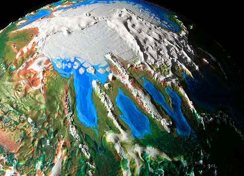
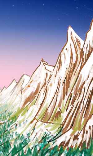
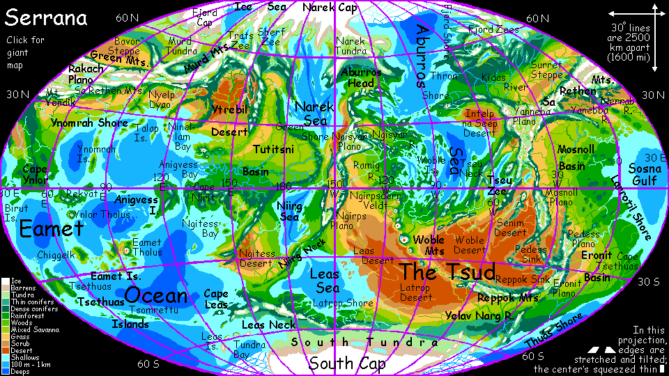
We'll begin at the still point--the pole. It's a strange, spectacular place; Earth has nothing like it. Quite by chance, a narrow, rugged mountain chain crosses the pole. Come to think of it, Earth has one too: Lomonosov Ridge. It's just drowned under two miles of sea! The Polar Range links the two small polar caps: Narek Cap (on the right), a bit smaller than Greenland, and Fjord Cap (left), about half as big. It also divides the Ice Sea from the Aburros--not that it's easy to tell that's water under the ice! To us, shivering atop the ridge, the range seems like a line of monstrous yellow fangs (bare golden rock-ribs too steep in many spots for snow to cling) rising from a single ice plain. Like some ruined Wall of China after eons of savage blizzards... but up to two miles high.
The Ice Sea below us is as big as the Mediterranean (a million square miles, 2.5M sq km). In summer, the north end of this brackish body is an ice shelf 600 km wide; in winter it grows to a thousand or more. But even in the worst winter, the south end remains ice-free. Glaciers from both caps and the Polars calve into the sea, so the ice shelf is complex, cracked, and often broken by polynyas (holes of open water); sea life is rich. The southern shores are tundra; in this era, the treeline doesn't quite reach the southern tip.
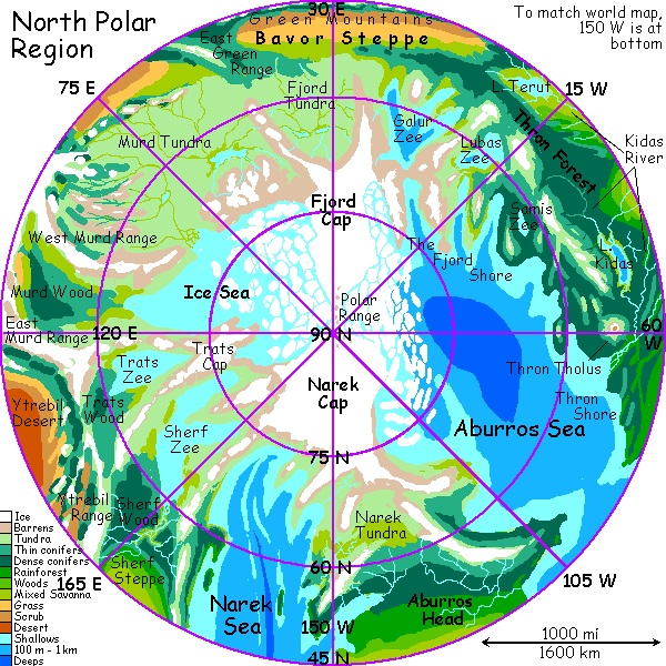

To the southeast is Trats Zee ("zee" means a salty but small body like our Aral Sea; Trats is only 1000 km long and 320 wide--625 by 200 mi). Trats Zee thaws fully in summer, and no glaciers calve into it. Most of the shores are bog and tundra inhabited only by nomadic mammoths, but the Trats Basin south of the sea, at the feet of the northern Ytrebil Range, is at least thinly wooded--harsh country, but livable.

Further southeast, over the low but glaciated Trats Range is the Sherf Zee (Sherf sounds more like sheriff than shirt). It's 1500 km long--as big as the Caspian. The tundra finally ends on the south shore, below 60 N: cool dark woods. Sherf Forest reaches south 1000 km or more, broken only by a huge muskeg bog in its center. The few residents, forest hunters based in small villages, are a well-insulated subspecies of raptor called featherballs.
 To the south is Sherf Steppe, a prairie with hard winters but short hot summers--Serrana's Saskatchewan. Shepherds of two species roam the plain in summer: featherballs and cameloid Planians. Neither are numerous.
To the east of the prairie and sea, over the inevitable Sherf Mts, is the Narek Sea, third largest on Serrana, 5.5 million sq km (2.2M sq mi--less than half our Arctic Sea). The north end is near the Narek Cap, the larger of the two northern ice caps, rivaling Greenland, though lower--rarely over a mile thick. At present no large glaciers calve into the sea; there's a barren coastal strip. Narek Tundra lies east of the northern sea; south of it lies Aburros Head, a fertile but isolated plain whose only migration corridor is from the south, up the isthmus between Narek and the Aburros Sea, which the locals call Narek Neck (off the polar map). Because access was limited, mammoths never settled this country; only now that word has gotten out through other species are immigrants rafting across the seas to explore its wide plains.
West of Aburros Head and Narek Tundra is the northern Aburros Sea. The Aburros is Serrana's Atlantic, with a similar wasp-waist. This northern half reaches the pole; pack and shelf ice breaks off into low tabular bergs in summer. The southern half (off the map) is warm, shallow and island-dotted.
The northeast Aburros shore is a set of deep straight fjords--ice-smoothed but not ice-created, they're parallel mountain ranges and sagging fault blocks. The northern fjords are barren, the central ones tundra and bog, the southern densely forested. Inland are several marshy brackish lakes called the Fjord Zees. The largest, the Galur Zee, is nearly 1000 km long, rivaling the northern Baltic.

Again, nearly all the locals are featherballs, the shaggy cold-weather subspecies of raptor. These marsupial, feathered bipedal dinosaurs are the only one of the six intelligent species that likes the cool, dark woods. This isn't surprising; even here on Earth, large animals are scarce in deep woods, and Serrana's boreal forests are much smaller--fewer opportunities for animals to adapt, and less payoff.
Thron Wood is the exception--a forest much like primeval Northern Europe--both the scale and the look. It's likely to go on looking primeval, too: featherball villages are few and far between. They're not in the habit of clearing large fields for crops, instead relying on sparse forest produce--nuts, mushrooms, hunting, fishing, plus mining, lumber and carved wood (and they are master carvers) for trade.
Why don't they clear more? It doesn't occur to them. On Serrana, you adapt to the land, rather than adapt the land to you. This isn't a value imposed by religion or some inherent eco-nobility, just a natural outgrowth of Serranian communities--each species settles in habitats it likes, mixing here, pure there. Featherballs who like open country or dream of wealth from cleared fields just head south to the wider vistas in mixed villages--leaving these villages to the conservatives. Or conservationists. Same thing, to a featherball.
South of the long Kidas River, broadleaf trees and occasional meadows appear; the Thron Bay region resembles France. The population diversifies, too; non-shaggy raptors, tree-squid, hexapi, and even a few Planians and taurlopes can be found.
Inland, the climate grows slowly drier and the forest thins into riverine ribbons, until the Surret Steppe stretches east, south of the Fjord Zees. Too cold in winter for taurlopes, it's Planian country (see below), though some featherballs have experimental herds of cold-tolerant roos here, to see if ranching is viable.
South of Surret rises a long wall stretching thousands of km inland: the Green Mountains. They're not all that green--but at least there are some trees, in contrast to the stark steppes to the north and the high plateau to the south.
For the Greens aren't quite mountains, but more of a scarp; the rim of the high, cold Rakach Plano--Serrana's Tibet.
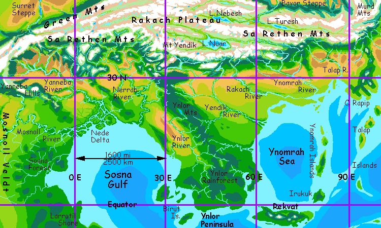
Rakach is a rugged plateau 3-5 km high (10-16,000 ft). It's geologically analogous to a small Terran continent or Venus's highlands, a raft of light granites floating on the heavier basaltic rocks of the lowlands. And it's huge: 5000 km long and around 1000 wide (3000 by 625 mi). Its alpine basins between the two rim-ranges cup great frigid lakes: Nebesh, Turesh, and Nuar, fully 600 km long.
The plateau's southern edge is the Sa Rethen range, even taller than the Greens, and rainier--Serrana's Himalaya. The Sa Rethens snag all the storms from the south--narrow but lush climate-bands follow contour lines along their steep south slopes. Fully 100 peaks top 8000 meters (26,250'), and Mt Yendik is 11 km high (over 36,000'). It's a savage, jagged, spectacular wall--Serrana's tectonics are more active than Earth's, and the gravity is lower, or these spires could never exist. Only Mt Woble, a near-Martian volcano in the south, is taller.
Rakach is overwhelmingly Planian country, though a thin population of aboriginal mammoths is scattered through the uplands. Only a thousand years ago, Planian immigrants from Yanebba Plateau started farming the river valleys. Planian crops, developed in similar plateaus in the other hemisphere, do well in these bottom lands, and their population's boomed.
There's a cultural boom as well; the Yanebbans were a relatively cosmopolitan people, used to trading. From a barrier, the Rakach region has become something of a highway between the huge, lonely north and the more densely settled shore of the Eamet Ocean.
Just north of the mountains lies Surret Steppe, and further east, Bavor Steppe, even harsher--hot dry summers, cold dry winters. Here too, Planians are spreading, though their crops require irrigation here. Most are nomadic herders. While Rakach sees friction between planians and mammoths over land use, mammoths have never liked these steppes, for they're too hot in summer and dry year-round.
The only other inhabitants, featherballs, get along well with the calm, easy-going Planians; instead of competition, they tend to share camps, food, policy discussions, and, increasingly, clan affiliations. A hybrid society is developing.
A long line of cliffs marks the end of Bavor Steppe. This Bavor Escarpment is south-facing, and thus rather warm for the latitude; villages are strung like beads along its sheltered feet, especially where lakes pool. Shades of central Asia's Silk Road!
Atop the escarpment, streams run north--when they run at all. This is cold land exposed to polar winds: Fjord Tundra. To the east over the low Green Range lies Murd Tundra, largest in the hemisphere--nearly the size of Northern Canada. The two arms of the Murd Range partially shelter a third basin even further east, Murd Valley; while its north coast on the Ice Sea is tundra too, much of it is bog and forest dense enough to sustain scattered featherball villages. Incidentally, Murd is pronounced more like "mothered" without the "th" than like "nerd", by the locals--if you can find any locals. It's Serrana's Siberia--while a strip of southern woods above the Bavor Escarpment support a few featherball villages, only mammoths really like Murd. Perhaps ten thousand of them. Over an area the size of Canada!

Still, let's indulge in wicked Terran northern bias, and not do the south pole. This was bad enough. Brr!
Sorry I'm being such a wuss about ice. If only I had longer feathers.
Serrana's homepage - Peoples of Serrana - Culture - Evolution - Gazetteer - How I Built Serrana
World Dream Bank homepage - Art gallery - New stuff - Introductory sampler, best dreams, best art - On dreamwork - Books
Indexes: Subject - Author - Date - Names - Places - Art media/styles
Titles: A - B - C - D - E - F - G - H - IJ - KL - M - NO - PQ - R - Sa-Sk - Sl-Sz - T - UV - WXYZ
Email: wdreamb@yahoo.com - Catalog of art, books, CDs - Behind the Curtain: FAQs, bio, site map - Kindred sites