Venus Unveiled: Themis
OVERVIEW
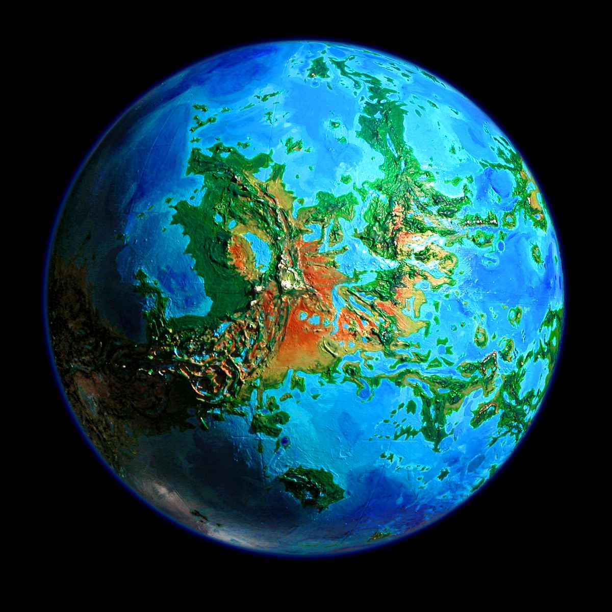
Themis is a southern continent the size of the Amazon Basin, and even wetter: the biggest rainforest in the solar system. It's one of three small continents linked by narrow landbridges: Themis itself, Parga to its west, and Phoebe, the largest, to the north. They form a ragged C-shaped supercontinent around the small Dzerassa Sea; and just east of Themis lies a fourth small continent, Dione. Themis is low, with a ragged coast and ten huge lakes. The central highlands, an east-west strip, aren't Earthly mountains but a bubbling mass of overlapping coronas and volcanoes, with deep lakes in the chasms between. Volcanic Mt Tefnut in east Themis is the highest peak.
FLYING TO THEMIS
The simplest way to reach Themis is from Cape Atai, at the southern tip of Phoebe (about 1 o'clock on the map). Let's make it afternoon...
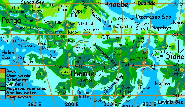
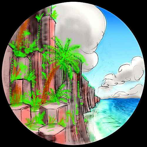
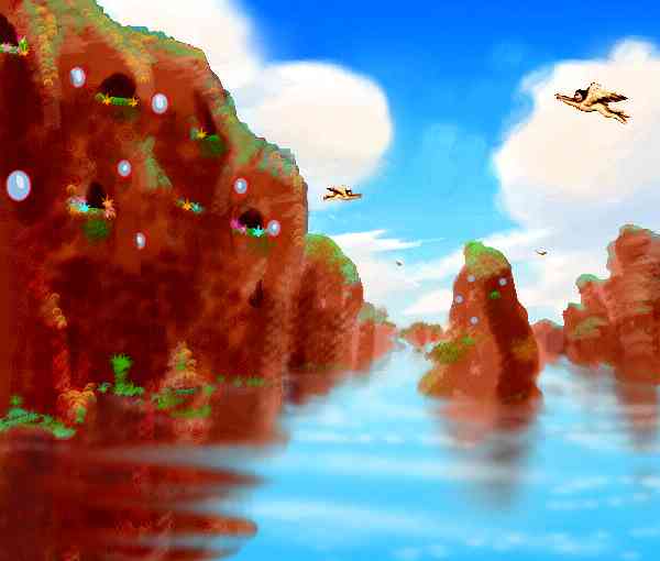
You're standing on red cliffs looking down into deep dark water: Pinga Chasma, a rift that crosses southern Phoebe and just marches into the sea. The twin points of Cape Atai are ridges flanking the rift-valley below--a spreading zone like East Africa's. Under your feet, too slowly for you to see, new land's being born.
On the horizon, a steep volcanic cone rises from the Dzerassa Sea: Mt. Kwannon, named for the Goddess of Mercy. Kwannon's a narrow, steep peak, but lava flows have built up an island 100 km wide. The volcano, too, is likely a child of the Pinga complex.
You spread your wings and grab air and jump off the sea-cliff. It takes an hour of steady beating to near Kwannon. The trade winds here blow east, so you veer round to the west face of the mountain and ride the updrafts higher and higher, to land on Kwannon's summit.
Over a deepwater channel to the south, faint and far, stands a second mountain: Justitia. I don't have to tell you which goddess she is, do I? Justitia's near slope is as steep as Kwannon, but beyond the peak the sea turns shallow, so Justitia's lava flows have built up a fan-shaped island 250 km across, spreading nearly to Themis's shore--your goal.
The twins form a flyway between the two continents. Justice and Mercy, throwing lava at one another
You dive down the south slope of Kwannon, faster, faster till your eyes water. You beat across the channel to Justitia, though from nearer sea level, the island sinks back under the horizon and you seem to be heading suicidally into an empty sea. It's a long flight; several hours before you land on Justitia's beach. The mountain's slopes above you are thickly forested, for the soil's fertile (volcanic ash) and the weather mild and subtropical. You sleep on the beach, having already flown over 500 km today.
When you wake, it's late afternoon--Friday. The light on Justitia's east face is noticeably warmer, and its shadow sprawls into the western sea. You follow the shore round to the sunwarmed east, where the rising air is, and into the lava flows. The southern fan of Justitia is a patchwork of low grassy ridges, wooded valleys, and small ponds--depending on what shapes the lava froze in. You wander south, lofting over the cliffs and raw spots, sinking over the woods. Hours pass, and the tongues slowlly lower. At last they're awash in the Dzerassa Sea, mere twisting reefs (the black rock instantly light with coral). And then they're gone. A narrow coral strait, and you're on Themis
The fertile, wooded coast is called Cape Tamiyo. It's rainier than the Twins, but not Amazonian like the mainland to the south--where you head, over the low ridge behind the shore. The forest rises languidly to a ridgeline, and languidly drops. More water opens before you, left and right. Tamiyo is a long strip paralleling the mainland's north shore for 400 km, sheltering two long sounds. Off to your right is Tamiyo Bay. Ahead is Tamiyo Neck, a low green strip linking the cape to the mainland--the hills beyond are Tamiyo Corona, the original source of the name. (So few features on Venus have been named, described, even noticed yet! So established names are thin on the ground.) The shorter eastern sound on your left is squarish Tunehakwa Bay, 200 km long, with a narrow mouth. You veer left, over the east shore of the neck, across the lowlands between the Tamiyo Hills and the range to the east: the Tunehakwa Hills, carpeted in Amazonian rainforest.
Ahead is a plain of huge emerald trees to the horizon, under a dappled sky of cumulus clouds. On the horizon, a turbulent clouod-knot probably marks Mt. Tefnut, highest peak on the continent. But it's still 250 km southeast. You'll get there, but first you have business to the east. Into the Tunehakwa Hills, where the trees shrink to mere Earthly size...
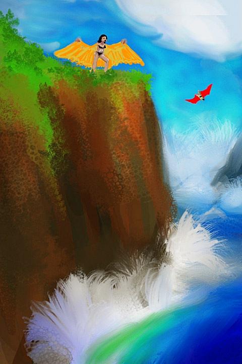
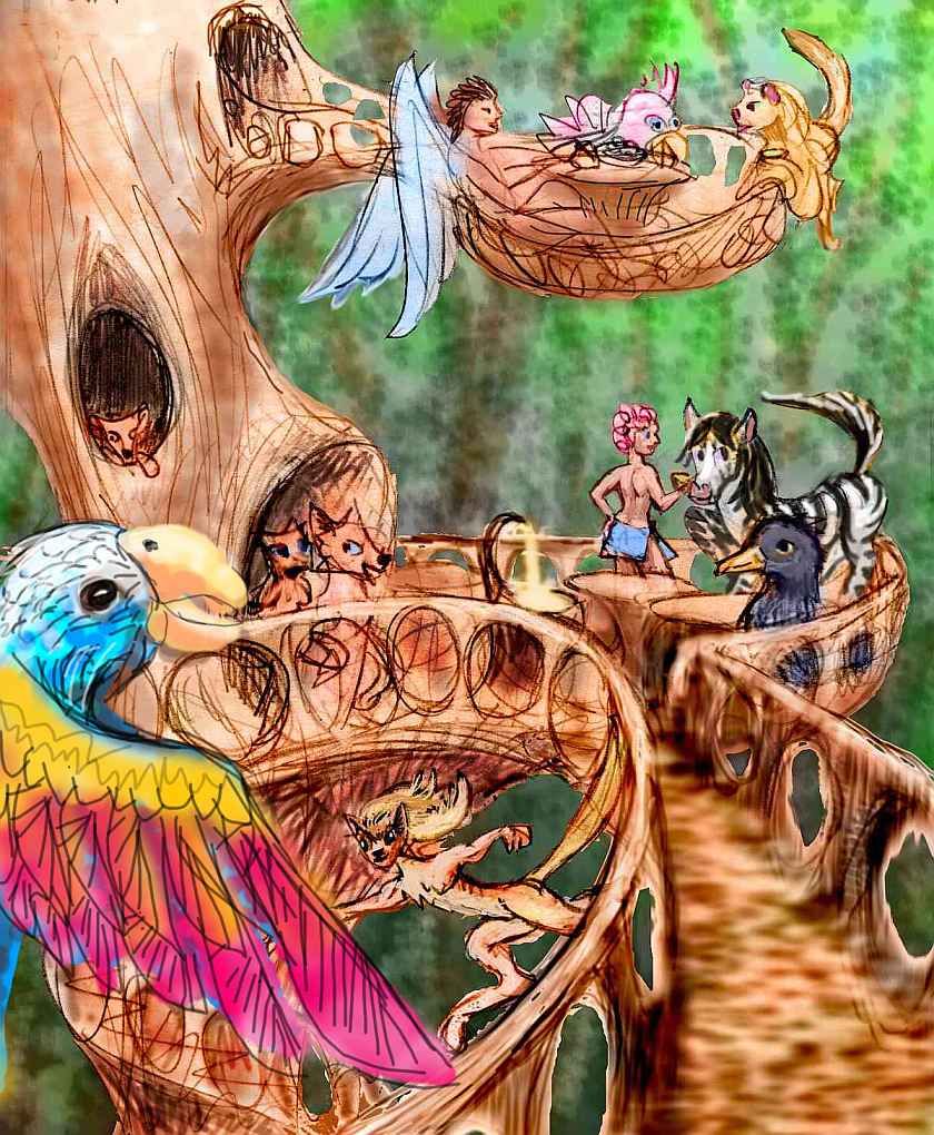
Tired, you look for a landing plaform in the canopy, the sign of a tree-village. You sleep in a commune of fifty giant crested cockatoos, with 4-meter wingspans and 25-kg bodymasses. Bonobos and various parrot species form the majority in this region. That bonobo-derived people are well suited for this land is obvious, but the giant parrots shouldn't surprise you either. Even on Earth, they had the same social pressures towards intelligence as primates--but Earth birds are severely constrained by flight weight. Not on thick-aired Venus! These big birds had room to evolve much bigger brains, giving them behavioral advantages... like civilization.
But I promised I wouldn't stray too much into science-fictional cultural speculation, so I'll leave the cockatoos a little privacy in which to design their own society. I'll only say that it's a good thing you're tired, or you wouldn't be able to sleep. Cockatoos are nice folks, but loud, loud, loud.
When you wake, you head east into the sunset. The glare's no problem--you fly up the long shadows of the big puffy clouds dotting this mainland sky. Below, Tunehakwa ends suddenly, in a set of curved, concentric ridges, each a bit higher, curving a bit sharper: the edge of Persephone Corona. You climb patiently, riding the westerly wind. The final ridge is a ring 100 km across. Its inner face is a red and black cliff veined with lime-green trees and vines, over a deep oval lake. True to her name, Persephone's heart sank to the underworld. Right now it's a bloody heart, too--or should I say a big red pomegranate? Magenta with sunset fire.
You fly round Lake Persephone, admiring the mirrored cliffs (cliff-sheltered, the lake's windless and waveless). Should you follow the other fliers? They're flocking northeast, where a cape 500 km long leads to the continent of Dione, over narrow Oakley Strait. Cape Persephone's the main flyway between Themis and Dione--but Dione's another tour.
Due east you see red water gleaming--an arm of Persephone Gulf. You follow the shoreline out to a lesser cape where you can view the Gulf: Cape Nevelson. The cape itself distracts you: two great cliff-walled horns, luminous now in the setting sun, holding a deep-sunk caldera, now flooded by the Gulf. And it's not alone: a larger cape floats luminous on the southern horizon, a larger volcano with a still larger caldera--Vovchok Patera. You set out over Nevelson Bay toward Vovchok, over small islands and coral reefs, lurid in the low light, casting long darkwater shadows. An hour or two, as Vovchok rises before you... up its ruddy bluffs, up the long slope--it's a true mountain, unlike Nevelson's low vent. Up over the lip--and Vovchok's revealed as another crater lake, like Persphone stretched vertically: arcuate cliffs, but taller, and bloodier in the lower light, the same round lake, but deeper, darker, stiller, a pool of blue shadow reflecting arcs of flame.
You sleep on the caldera rim. When you wake, it's Dusk. The sunset's still in full display, but the pool of firelight on Vovchok, the last direct sun, is gone. To the north, the great arch of the rings shines white, adding a cooler light. Shadowless, the land glows.
The Gulf of Persephone stretches to the horizon, north and east. That green land to the northeast isn't Dione, but an island only halfway across the gulf--Seseg, about 120 km across. To the south is the islandless coast of Vovchok Bay. You skim down the south slope of the Patera, dodging between emerald treetops as big as clouds.
But as you near the sea, suddenly the slope disappears and you're sailing bewildered over an echoing void. Waves far below smack head-on into beachless cliffs. Vovchok Scarp! Megaforest above, sea below, black basalt cliffs running miles, sometime cracked into hexagonal columns that lean out in broken, drunken towers, like the ruins of a city built by mad black bees.
You follow the Scarp southeast for hours, as the sea at its foot turns to beach, marsh, then a jungle plain to the horizon--the Rodina Forest. This is your first close look at Venus's one unique climate zone, warmer and wetter than anything on Terra: the Megazoic. Here in Themis's heartland, early science fiction's imaginary Venus comes true: shallow seas, steamy jungles, intricate life-webs up in the bright canopy, gloom at the swampy roots. Primate villages and bird-towns are all 100 meters up, in trees trained to grow hollow--doors, windows and all--up where all the light, growth, flowers, fruit, birds and animals are. Trees top out at 130-140 m tall (400-460'), with four to six times the bio-density and -diversity of the Amazon.
Dusk is good in the Megazoic. The forest comes to life after sunset, in the cooler light of the equatorial rings. Only mad dogs and tourists fly in the midday sun. It's why we started in mid-afternoon, so you'd reach these steamy plains after nightfall.
Through Dusk and Eve and Ring, you flap leisurely down the jungle coast, sampling its strange cultures, the arboreals and avians and tree-people who photosynthesize by day and move by night... The weather's hot but bearable, with intermittent showers to cool you.
At last, water appears inland--Faravari Bay, a long lagoon paralleling the coast for 200 km. Hours later, as you cross the mouth, land appears offshore: hilly Faravari Island, 160 km long, and Amazonian rainforest coast to coast--though sea breezes keep it slightly cooler than the Megazoic shores of the mainland.
On Yule, the coast heaps up into a mountainous corona: the Bibi-Patna Peninsula, 500 km wide. The southeast corner of Themis, it shelters huge Chloris Bay. A narrow tongue points 400 km further south, but let's not follow it: it fades into an island chain stretching 1200 km south to Neringa. Head west, instead. Unbroken rainforest covers Bibi-Patna Corona and its central bay (on the southwest side, the sea's breached the low center of the corona, forming a bay 100 km long).
Early on Rain, which is true to its name, you don't go far--just over the eastern mouth of Chloris Bay to Navolga Island. Navolga is fully 300 km long and nearly as wide. Not that you can see much of it--the forest fades into dim silver rain a mile or two off. A mild rain--even drenched, you're warm--but you tire of it at last, and climb above the dull stratus into the bright cloud-towers above, and fly on in ringlight.
As you cross the rest of huge Chloris Bay, a sound 1000 km long and 2-300 wide--Themis's inland coral sea--you spot a some of the Chloris group through cloud-gaps--islets a mere 20-50 km long. Ahead, disrupting the clouds but not tall enough to break through, is a third Chloris, the source of the name: the hills of Chloris Corona, on the west shore. All these bay lands are Megazoic rainforest over 100 meters tall, of course. From here, a nubbly, wet green rug.
You hunt for a break in the clouds, and a village landing-pad, and sleep dry (and alone, declining the usual pro forma offers) in a bonobo free-love commune.
On Witch, the rain eases, and the ringlight shines through in dramatic beams and patches. Lurid green and silverblue dapples on the land and sea--only that huge water to the west and north is fresh, not sea. Lake Siduri, the biggest in Themis, 400 km long and 300 wide. Siduri's one of the Low Lakes, a chain of three great basins strung across central Themis's lowlands. Siduri's the easternmost, largest, and lowest, named for the mountains cupping its north end. Lakes Meiboia and Nzambi pour into Siduri from the west; Siduri in turn drains south into the Helen Sea, staining it hundreds of km out with muddy whorls, like cream in coffee. The shores of the lake are Megazoic rainforest--like all Themis's southern lowlands.
What else is memorable, on the flyway north through the Siduri Hills? Spotting one of the shy, solitary orangutan-derived people, well adapted for rain and canopy life with her long red waterproof fur. Like their ancestors, the Themis orangs are natural hermits, keeping in touch even with family and friends mostly by email, their emotions mostly engaged by a mystical communion with the forest--noting species, distribution, succession, evolution not as a scientific pursuit but a spiritual calling... A strange life. People who live in trees? What about the people who ARE trees, feeding by photosynthesis, harming no living thing (and, some cynics say, a bit too proud of it)? Oh, well, why make fun of them? One lets you sleep inside him, in a room he grew in his crown specifically for guests. A strange feeling... In such a feverish, rich ecology, with millions of species and more each week, there's elbow room for social and biological experiments. No point in repeating possibilities I've written of in other tours through Megazoic rainforest, like Hathor.
On Dawn, you leave the lowlands. North of the low Siduri Mts is a long wall, the Rodina Range. Over it, a narrow, deep mountain lake 300 km long, Lake Rodina, nestles between the Ukemochi Mts and the Rodina Range. It's the westernmost of a chain of seven great lakes winding 1600 km through the mountain chasmas of central Themis, collectively called the High Lakes. It's still hot and rainy, but being an upland somewhat sheltered by mountains, it's less steamy and stormy than the Themis lowlands behind you--though that just means six meters of rain a year instead of 12.
Past the head of Lake Rodina, you spot a red fire-glow. It's Mt Tefnut, the great volcano dominating east Themis. Not an eruption--just catching the sunrise light. You climb up the southwestern flank, over some of the wettest land on Venus--the rising slope wrings extra rain from the clouds, if that's possible. The summit's above most of the rains, but this region is so hot and damp that thunderstorms rise high enough to shower even Tefnut's peak often enough to keep it green with alpine fern-meadows--glowing that strange red-green only seen at this hour.The summit never freezes, but suffers hailstorms now and then, with stones the size of golf balls, during thunder season--the only ice for 2000 km at least! The rains that follow quickly melt them. A long blue shadow sprawls for miles across the golden clouds to the east--and Tefnut casts a second, invisible shadow there. But Themis is so wet that Mt. Tefnut's rainshadow is merely opener woods with a few meadows, instead of Megazoic jungle.
You find a shady spot behind a rock and sleep on Tefnut's summit. It's almost uncomfortably cool, but that's a novelty on Themis...
On mid-Sunday, when you wake, you dive down the ferny cliffs, back into the dappled sea of cloud.
After hours of wandering over a maze of ridges (no sign of the concentric rings typical of coronas), a pattern develops at last--parallel valleys, leading north. They fuse into a notch as straight as a mythical Martian canal. Mt Tamiyo, a volcano 2 km high, rears on your left, and narrow Lake Tamiyo gleams ahead--the second of the High Lakes, after Rodina. For two hours you race along this unnaturally straight gash, waiting for it to wind, like all the other rifts you've seen on Venus. No. Suddenly it just ends, in a mountain wall of clinging green striped with cascades. No. Not ends. A gulf opens on your left. The lake jags sharply and runs back southwest, forming a gigantic V. This arm too is as straight as a road-cut. The V is unbelievably clean, here at the one spot you can see both arms. It's as if Venus herself signed her work, carving her initial...
At the lake's south end is a rolling plateau, dotted with ponds nearly invisible under the great trees. You sleep in an inn that's a sentient tree, who grows detachable lunches and hosts parties in exchange for gossip and travel-condition updates.
On Monday, you fly into the hills to the west, up until you're in the bizarre Semiramis Mts, which march straight as soldiers for 500 km, turn as tight as a paperclip, and march right back, pinning a narrow lake between them. Lake Semiramis, 300 km long, is the third of the seven High Lakes. It's midway between the two classic Cytherean types: 1) the lake filling the sunken center of a corona, and 2) the long narrow rift-lakes found in chasmas. Semiramus seems to be both. You wonder if odd, angular, riftish coronas like Semiramus and Tamiyo's giant V result from overcrowding, like the angular, nearly crystalline shapes of soap bubbles en masse. Or is it tectonic forces that are overlapping here? Is this land both bubbling up and stretching/squeezing, all at once?
Oh, well. It's a nice place to swim. The trees don't overhang the rocky shore here. There's a reason, though it won't be apparent til tomorrow.
Tuesday: you cross the lake. On the southern wall of the Semiramus Valley, there's a crack. No, a canyon. In you go... and so does the outflow from Lake Semiramus, down a savage whitewater chute, falls dropping to pools dropping to falls. This canyon, unlike nearly all others on Venus, really is water-carved. Lake Semiramus grew quickly once the rains began, until it filled the basin. It burst through here, causing a great flood. The present lake shores haven't been land long enough for the forest to climax. The canyon, too, while green, has mostly small trees; it was ripped down to bare rock by the flood.
These days, the river's stabilized; but its white water attracts hordes of vacationing Amazonian otters, from all over Themis. The squeals and laughter of the cubs (and adults; the playfulness of otters is one of those racial stereotypes that arose because it's undeniably true) nearly drowns out the water's roar.
At last the slot opens out, and a wider, deeper valley spreads before you, with a sheet of water deeper blue than most of Venus's seas. And that's not illusion: Lake Zywie is nearly two km deep, like Earth's Lake Baikal. Zywie is fourth of the seven High Lakes, lying in the same chasma as Lake Rodina. In between them are the Ukemochi Mts, a high corona shouldering the rift aside for 300 km. The Ukemochi River winds down through the wide valley to your left to join the white Semiramus here; together they run down to the lake.
You take your time wandering up the Zywie rift, since it's near noon, and quite hot even here in the highlands. At least it's less humid--less rain here too, sheltered by the Ukemochi and Zywie and Semiramus ranges. You like the relative openness of the land--lower trees, even a few meadows. Not just the more reasonable rains--the land was flood-scoured. It's hard for truly gigantic trees to root in bare rock. Maybe in a few centuries...
At Lake Zywie's west end is a low ridge hiding a small deep nameless lake. You fall asleep on its shore, listening to a small family of coyotes practicing a hymn to the rings (emigrants were forced to transfer their affections from the lost moon). Howls in sliding harmony. Their young cubs keep getting carried away, and forgetting the words, and flapping into the trees. I did mention their wings, didn't I?
When you wake, it's even hotter. Wednesday, just after noon. You don't travel far--over a little ridge, down to Lake Tacoma to swim. You glide on the plentiful thermals from beach to beach all day. The water's pleasantly cool--Tacoma's even deeper than Zywie, though small by Cytheran standards--only 160 km long. It's nestled between the Latta Mts (the southeast arm of the great Shulamite Range), Tacoma Corona, and the tall Semiramis Range to the north, though they're finally bending away...
Early Thursday: the heat breaks a bit. Thunderstorms! Not safe to fly in... You attend a very nice concert in a cockatoo village--a cappella chorales. It's too hot to dance to, but at least you're not being rained on. Or lightning-fried.
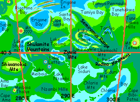 Later, when the storm tatters and clears, you climb southwest out of the Tacoma/Zywie/Rodina rift valley, over a broad, low ridge to the wide curving basin of Lake Latta, a peanut shape 200 km long, Latta nestles between Latta Corona (an arm of the Shulamite Range) and the southern Zywie Range. Lake Latta, even more than Semiramus and Tamiyo, isn't clearly a coronal or a chasmal lake--it just squeezes between competing highlands. Latta's the sixth of the seven High Lakes--sort of. The Latta Valley's shallower than the northern chasma, and its wide mouth is open to storms from the south. Your skin feels the difference--hot and humid, almost like the lowlands on the southern horizon. Transitional. In fact this valley's a migration corridor for southern lowland species invading the cooler, drier northern lowlands. If they can survive Latta, they'll do fine in the north.
When you wake, it's Friday--late afternoon. The sun's sinking at last, but it's still too hot to contemplate heading back into the Themis lowlands. There's only one way to beat the heat--go up. And up means west.
The Shulamite range is one of the highest on Themis. Together with its eastern arms, Latta and Tacoma Coronas, the Shulamites create a plateau 500 km across, dropping sharply into chasmas both east and west. The Shulamite plateau is notably cooler than most of Themis, though hardly dry--the forest shrinks from Megazoic to merely Amazonian. I think! There's a grim possibility suggested by certain inland Andean slopes--such highlands just above a hot rainforest may end up a cold, damp, windy, wretched drizzle forest, where few animals of any size do well. But the examples I know of are all in spots where clouds are forced upward and drop their rain halfway. Shulamite and the Shiwanokia Plateau beyond it are free-standing, so many storms will go round; they're more analogous to the coffee/tea highlands of South Asia or Ethiopia. Or they may be in between: misty forests like the Guyana uplands, but not too cold and damp for animals.
Oh, let's be optimistic and declare Shulamite a coffee-type plateau. Besides, then you can reward yourself for that hard climb, by sampling some fresh local brew in a tree cafe. Really, really fresh--the tree is the cafe owner and the coffee farmer. Grows the berries on its twigs and grinds them on the spot! Of course the downside of all these competing non-chain cafes is that every inhabitant of Shulamite is perpetually wired. And given the jungle here, most of them are parrots and apes. Picture a chimp on espresso. Now multiply by one million. Noisy, eh? The Shulamite Plateau culture: cafe chimps banging away on typewriters, writing the Great Cytherean Novel, while the parrots write short stories (even on coffee, typing's slow when you're built to hunt and peck). Arguments, screeching laughter, endless debates, critiques, chimp egos on caffeine. A nice place to visit but you sure can't sleep here...
But all good manias come to an end. You flap and sip your way across the manic plateau, but at last the high drops away. Below you to the west sprawls a deep, L-shaped mountain lake 320 km long, last of the seven High Lakes. Across the valley looms the high misty wall of Shiwanokia Corona, even taller than Shulamite. Definitely a cloud forest, this time. Home to lots of unique species, like the Axolotl People, graceful but slippery... Maybe we'll skip it. The sun's getting low. During the night, the lowland's the place to be. Let's turn south along the lake.
LOWLAND THEMIS
Setterday now. Low light, tinting the puffy clouds gold. You're following the Shulamite River south out of the mountains. Two nameless mile-high volcanoes are silhouetted on the eastern horizon. Ahead is the silver gleam of Lake Meiboia, one of Themis's three Low Lakes. Meiboia is the smallest (a mere 300 km long), the westernmost, and the highest. It drains into Lake Nzambi which in turn feeds Lake Siduri.
Meiboia's shores are Megazoic rainforest (sigh). Pretty, but we're a day too early to appreciate it--still too hot and sticky to travel far. You end up freshwater diving in Meiboia, not because it's a scenic wonder, (the water's a bit muddy, and tangles of mangrovish roots make it dangerous for the unskilled and ungilled), but just to stay cool. You strike up a conversation with a family of fructivorous freshwater dolphins--their ancestors swiped a few enzymes from Amazonian fruit-eating fish, who harvest windfalls in Brazilian rivers--there, the fishy feeding frenzy usually ends in the dolphins feeding on the feeders, but here the dolphins just open their mouths and dine on fruit salad. It only sounds monotonous if you forget how varied the trees are here--thousands of species, dropping avocado-like oil-fruit here, proteinaceous nuts there, and sweet, aromatic berries the size of your head just about everywhere. These river dolphins have the best sonar of any cetaceans (while whales were being fooled by echoes into grounding themselves, river dolphins were navigating blind amid complex shallows and tangled roots). However, their vision is so-so--eyes were nearly useless in the muddy Amazon tributaries. This family's heard about a related species over in Hathor that's debating whether to regain full sight via gengineering. Would this destroy their preternaturally good hearing--and corrupt their oral culture?
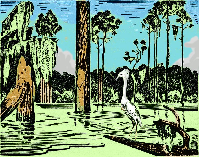
You also spot some peculiar looking herons. Sapient of course, you expect that by now, but you don't expect the small but apparently functional hands--not part of their wings, but an entirely new pair of limbs. And very useful they are, if you're harvesting those swamp mussels. Someone evidently decided to fix that evolutionary dead end that leaves birds so awkward as tool-users--either your beak (and then it's hard to see what you're doing, not to mention you're shoving your face into what you're messing with, not always a safe business) or your foot (leaving you balancing wobbily on the other.) Even very light, delicate, but dedicated hands have to be way more dexterous.
Dusk: you follow the sunset colors downriver to Lake Nzambi, the last of Themis's Great Lakes. There. You're done! Mzamo drains into huge Lake Siduri, which we've seen before--hundreds of km away, on its far shore. Above us to the southwest, cutting the lake off from the sea, stand the Nzambi Hills. It's almost cooled enough to climb up into them and explore. Almost...
Instead, you spend most of Dusk and Eve just floating in the lake... in this neck of the woods (and they're big woods) there's a disadvantage to being animal instead of vegetable. Ask any vegetable--they'll all tell you. This part of Themis is one of Venus's great tree-cultures. Photosynthesizing appeals to a certain sort of soul, especially the idealistic, contemplative sort, so it's unsurprising that megaforest politics on Themis, Tellus, Imdr and Bell all have a whiff of patchouli--both from Gandhi (trees don't have to eat living things, right? How noble!) and the hippies' anti-work ethic (grow your own! In fact, grow yourself!). Of course, whether you got started as an AI or in an animal body (including human), or grew up as a tree merely hearing about mobility and dexterity, once you're more than a sapling, you'll want to make some improvements. So trees have hands, eyes, ears... they already have an excellent sense of smell, of course! That pheromone thang...
Themis and Bell are the two rival homes of an art form we find hard to comprehend--bearing new species for esthetic reasons. Trees combine and swap genes, then grow strange fruit that hatch into flowers or plants or creatures never seen--even strange new people. It's partly about the sheer beauty of new forms, but also about the role of the new creatures in the intricate ecological web of the rainforest, which, because of its sheer biomass and diversity, can tolerate a lot of novelty. The prepondering biological themes shift slowly as the community's focus shifts, pulled this way and that by innovators. (Curiously like two other art forms: high fashion, varying in detail yet following annual trends, and whalesongs, another group creation that mutates slowly over the seasons.)
We may be appalled at the idea of such casual genetic engineering, but they'd be equally appalled at ours--all for selfish profit. Fundamental to their ethics and esthetics is this proposition: every altered gene must benefit its individual bearer and harm no one else. Try it. Ain't so easy, is it?
On Yule, you reach the south shore of Themis--Bernadette Bay, a sound 600 km wide between Cape Ama and the easternmost arm of the Nzambi Hills. Bernadette Crater is now only a ring-shaped seamount off Cape Nzambi, well below the surface, though in a few centuries the corals on it will build an atoll. The lands around the bay are low, hot and rainy, Megazoic climax rainforest, topping out at 125 meters (about 400'). Bernadette Island, further offshore, is geologically unrelated; a corona too small to merit its own name, at least in the corona-crowd that's Themis. Still, the island's lush--and big, at least 150 km across (low relief, so it's hard to determine the exact shoreline).
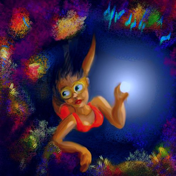
It's a dark and (intermittently) rainy night, so you do some night-diving on the coral reefs. The water's warmer than the rain, anyway. From underneath, in the dim reddish ringlight, the great drops stabbing into the sea look like fierce fingers of bloody glass. Great-eyed creatures, glowing blue and phosphorescent green, rise near the surface on these dark Yule nights. At last, a bit nervous at the sheer size of some of those eyes, you flick on your light and they flee. In their place, a rainbow of sleepy, curious dayfish flock to your lure...
You dine that night in a tree-inn staffed by herons. They serve sushi of course, but only simple creatures like clams, mussels, scallops, jellyfish--influenced by tree-ethics, most folks in this squeamish region won't eat anything with a brain. Not much need anyway, in a land so lush.
When you wake, it's Rain, and true to its name. But the night's mild, and the ringlight's back, shining even through the clouds, so you flap on toward Cape Ama, southwest tip of Themis, formed by Ama Corona. The rainiest part of a rainy continent, for it takes the brunt of storms coming in off both the Helen and Wawalag Seas.
You decide to push on despite the rain--after days in the Megazoic zone, it's almost a pleasure getting a bit chilled! On the right, as you fly north along Cape Ama's west shore toward its root, stands a lone volcano in a wide gray hat of cloud: Mt. Meiboia, which gave its name to the great lake behind it.
After Meiboia, an arm of the sea thrusts in. You cut across it, heading north. Ahead now on your right looms the misty Shiwanokia Plateau--you've flown round it. To your left, far offshore, another volcano rises from the shallow silver sea: Abeona Island, a stormy place. Abeona's a classic corona at least 300 km wide, completely hidden under Megazoic rainforest--like Cape Ama, Abeona gets the worst of storms from both seas.
On Witch, the thirteenth day, the rains trail off. That's partly geography--you're north enough now to be nearing the fringe of the torrid zone, though it doesn't feel much cooler yet. Ahead, a long ridge bars the way, studded with volcanoes: Cape Mertseger.
The peninsula's big and takes time to cross--400 km long and up to 200 wide. The western tip of Themis, it's jagged--shaped like a unicorn's nodding head. It's all rainforest of course--tree-ferns cling to its cliffs, right down to the water. Still, when you camp on the north side of the cape, you notice the heat's less clammy. A bit. Maybe.
When you wake, it's Dawn--a warm glow out to sea. You're on the shore of Sabin Bay, which helps cut off Parga from mainland Themis--almost. Sabin's shores are rainforest, though merely Amazonian--not a tree over 75 meters (250').
As the sky-display slowly brightens to its full flame, you ride the updrafts north along the sea-cliffs, stopping to swim now and then. Cape Lilwani is only a few hours away--your first glimpse of Parga.
But there's one last corner of Themis to see, before Parga. Inland burns a cone of fire... a tall volcano, catching the sunrise half a day before the rest of the world. You ride the dawn thermals up the mystery peak and look around (I've scoured the radar scans and maps for its name, but I seem to be the only person who's noticed it yet). The clouds catching the sunrise light are so fiery, against the dim land below, that you can't see much. Have to wait. It's pleasantly cool on the peak, so you curl up and sleep. You've gotten better at that--when you began this trip, going to sleep at dawn would be hard work. Not now. Adaptation? Or mere disorientation? You'll have noticed a dreamlike, sketchy, repetitious quality in this narrative... Time-rapture! Mess with the sleep cycle and that's what you get. And here you thought it was just my literary limitations...
You wake on Sunday. The clouds are still gold, the shadows long, but light reaches the land, now. You can see, except for the red glare hiding Sabin Bay.
South: pale blue, deceptively shallow-looking. That's not the sea, but the north end of Lake Shulamite. I told you it was big! The Shiwanokia and Shulamite Plateaus are just cloudy lines on the south and east horizons. Due north, invisible under the clouds, the Isthmus of Rigatona leads to the land of Parga. First we'll head northeast, into the last great corona of Themis: Erigone.
I can see the poster now. "When Coronas Go Bad"... In Themis, all the other reindeer, excuse me, coronas, form hills and plateaus--some with a central lake-basin, some not. But all display a lot of upthrust--maybe I should say up-bubble. But Erigone is perverse. Huge and brilliant on radar scans (meaning rugged) it's completely negative. Erigone's outermost arcuate ridges, steep and impressive, surround... nothing. A huge hole, now called Erigone Bay, 300 km wide. The arcuate ridges are now cliff walls dropping into the sea--clawlike capes east and west, but long slender islands in the north and northwest. Nested concentrically like Babushka dolls, with narrow sounds between, they make for interesting flying! Ask any of the local cliffdwelling sphinxes, angels and coyotes.
How far do Erigone's cliffs go into the sea? Are there vertical reef-gardens? You spend the rest of the day diving, and find out. Tired out from swimming (different muscles, after all) you sleep early again, atop an island cliff, looking north to tomorrow's island: Angerona.
Early Monday, you cross the channel north to the largest island in the Dzerassa Sea. Angerona resembles Haiti in size, climate and look--with one exception not far from our landfall on the southwest shore. Climb that steady slope an hour or so. You expect further coronal ridges, or perhaps a lava plateau--Angerona has that shield-volcano, lava-flow look. You top the first ridge... and it's the last. A deep oval caldera, flooded from the west, black-walled, the far side slate-blue in the haze. Even on a world notorious for huge calderas, Angerona's big. And bony--the cliffs aren't covered in green fur, as they would be back in Themis. Bare rock merely striped in moss. We've left the downpour zone.
From here, you could go back southwest through the Erigone Islands, then northwest to Cape Rigatona. It's an oddity--not only bends back on itself, but actually spirals, as neatly as if Andy Goldsworthy got a big art grant (and a REALLY big bulldozer). The Rigatona Hills, inland, the source of the name, are an absolutely classic "target" corona, with concentric ring-ridges, cupping several lovely arcuate lakes. And north of that's Lake Gertjon, the largest in south Parga--240 km wide. The climate's pleasant--warm but not stifling like southern Themis was. Still... it's a long detour to get to Mt. Mielikki. And I'm not certain about that spiral cape--what if it turns out to be like Percival Lowell's canals? I may be reading too much into ambiguous data.
Oops--too late! This whole project does that.
Let's just fly due west over the Angerona Gulf. It's straight into the glare of the morning sun, but there's a line of small islands to rest on, and it's the directest route to Parga.
FACT VS FICTION

World Dream Bank homepage - Art gallery - New stuff - Introductory sampler, best dreams, best art - On dreamwork - Books
Indexes: Subject - Author - Date - Names - Places - Art media/styles
Titles: A - B - C - D - E - F - G - H - IJ - KL - M - NO - PQ - R - Sa-Sk - Sl-Sz - T - UV - WXYZ
Email: wdreamb@yahoo.com - Catalog of art, books, CDs - Behind the Curtain: FAQs, bio, site map - Kindred sites